McConnells, South Carolina

Last updated

McConnells, South Carolina
SCMap-doton-McConnells.PNG
Location of McConnells, South Carolina
Coordinates: 34°52′1″N81°13′24″W / 34.86694°N 81.22333°W / 34.86694; -81.22333
Country United States
State South Carolina
County York
Area
[1]
  Total3.42 sq mi (8.86 km2)
  Land3.39 sq mi (8.78 km2)
  Water0.03 sq mi (0.08 km2)
Elevation
[2]
689 ft (210 m)
Population
 (2020) [3]
  Total280
  Density82.57/sq mi (31.89/km2)
Time zone UTC-5 (Eastern (EST))
  Summer (DST) UTC-4 (EDT)
ZIP code
29726
Area code(s) 803, 839
FIPS code 45-43675 [4]
GNIS feature ID1246582 [2]
Website https://www.townofmcconnells.com/

McConnells is a town in York County, South Carolina, United States and a suburb of York. The population was 255 at the 2010 census.

Contents

History

The Bethesda Presbyterian Church, Brattonsville Historic District, and Hightower Hall are listed on the National Register of Historic Places. [5]

Geography

McConnells is located at 34°52′1″N81°13′24″W / 34.86694°N 81.22333°W / 34.86694; -81.22333 (34.866827, -81.223465). [6]

According to the United States Census Bureau, the town has a total area of 3.4 square miles (8.9 km2), all land.

Demographics

Historical population
CensusPop.Note
1910 279
1920 247−11.5%
1930 27913.0%
1940 263−5.7%
1950 255−3.0%
1960 2664.3%
1970 213−19.9%
1980 171−19.7%
1990 157−8.2%
2000 28782.8%
2010 255−11.1%
2020 2809.8%
U.S. Decennial Census [7] [3]

As of the census [4] of 2000, there were 287 people, 101 households, and 76 families residing in the town. The population density was 83.4 inhabitants per square mile (32.2/km2). There were 107 housing units at an average density of 31.1 per square mile (12.0/km2). The racial makeup of the town was 71.43% White, 28.22% African American, and 0.35% from two or more races. Hispanic or Latino of any race were 0.70% of the population.

There were 101 households, out of which 37.6% had children under the age of 18 living with them, 63.4% were married couples living together, 7.9% had a female householder with no husband present, and 23.8% were non-families. 23.8% of all households were made up of individuals, and 10.9% had someone living alone who was 65 years of age or older. The average household size was 2.84 and the average family size was 3.38.

In the town, the population was spread out, with 27.5% under the age of 18, 7.7% from 18 to 24, 33.1% from 25 to 44, 23.0% from 45 to 64, and 8.7% who were 65 years of age or older. The median age was 36 years. For every 100 females, there were 102.1 males. For every 100 females age 18 and over, there were 94.4 males.

The median income for a household in the town was $41,875, and the median income for a family was $61,094. Males had a median income of $26,750 versus $22,100 for females. The per capita income for the town was $15,831. About 5.3% of families and 5.7% of the population were below the poverty line, including 14.1% of those under the age of eighteen and 8.1% of those 65 or over.

Notable person

Related Research Articles

<span class="mw-page-title-main">Livermore, Iowa</span> City in Iowa, United States

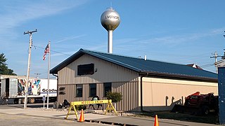
Livermore is a city in Humboldt County, Iowa, United States. The population was 381 at the time of the 2020 census. Livermore is the hometown of former University of Iowa and NFL tight end Dallas Clark.

Princeton is a town in Washington County, Maine, United States. The town was named after Princeton, Massachusetts. The population was 745 at the 2020 census.

<span class="mw-page-title-main">Slippery Rock Township, Lawrence County, Pennsylvania</span> Township in Pennsylvania, United States

Slippery Rock Township is a township in Lawrence County, Pennsylvania, United States. As of the 2020 census, the population was 2,913, a decline from the figure of 3,283 tabulated in 2010.

<span class="mw-page-title-main">Wolf Creek Township, Pennsylvania</span> Township in Pennsylvania, United States

Wolf Creek Township is a township in Mercer County, Pennsylvania, United States. The population was 716 at the 2020 census, a decrease from 832 in 2010.

<span class="mw-page-title-main">Fairfax, South Carolina</span> Town in South Carolina, United States

Fairfax is a town in Allendale and Hampton counties, South Carolina, United States. The population was 2,025 at the 2010 census, a decline of over one-third of its population of 3,206 from 2000.

<span class="mw-page-title-main">Lowrys, South Carolina</span> Town in South Carolina, United States

Lowrys is a small rural town in Chester County, South Carolina, United States. The population was 200 at the 2010 census.

<span class="mw-page-title-main">Saluda, South Carolina</span> Town in South Carolina, United States

Saluda is a town in Saluda County, South Carolina, United States, along the Little Saluda River. The population was 3,565 at the 2010 census. It is the county seat of Saluda County.

<span class="mw-page-title-main">Carlisle, South Carolina</span> Town in South Carolina, United States

Carlisle is a town in Union County, South Carolina, United States. The population was 436 according to the 2010 United States Census.

<span class="mw-page-title-main">Jonesville, South Carolina</span> City in South Carolina, United States

Jonesville is a town in Union County, South Carolina, United States. The population was 911 at the 2010 United States Census.

<span class="mw-page-title-main">Lockhart, South Carolina</span> Town in South Carolina, United States

Lockhart is a town in Union County, South Carolina, United States. The population was 488 at the 2010 United States Census.

<span class="mw-page-title-main">Sharon, South Carolina</span> Town in South Carolina, United States

Sharon is a town in southwestern York County, South Carolina, United States. The population was 494 at the 2010 census.

<span class="mw-page-title-main">Tye, Texas</span> City in Texas, United States

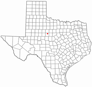
Tye is a city in Taylor County, Texas, United States. The population was 1,242 at the 2010 census. It is part of the Abilene, Texas Metropolitan Statistical Area.

<span class="mw-page-title-main">Madison, West Virginia</span> City in West Virginia, United States

Madison is a city and former coal town in Boone County, West Virginia, United States. The population was 2,911 at the 2020 census. It is the county seat of Boone County.

<span class="mw-page-title-main">Cedar Grove, West Virginia</span> Town in West Virginia, United States

Cedar Grove is a town in Kanawha County, West Virginia, United States. The population was 714 at the 2020 census. Cedar Grove was incorporated in 1902. Its name is derived from the time the town was established, when a large juniper forest, misidentified as cedars by early settlers, was growing at that location. Cedar Grove is the site of Fort Kelley and the oldest settlement in the Kanawha Valley, dating from 1773. Landmarks located here include the Tompkins Home (1844) and the Old Brick Church (1853). The current mayor is as of July 1, 2023, is Melissa (Missy) Young.

<span class="mw-page-title-main">Pratt, West Virginia</span> Town in West Virginia, United States

Pratt is a town in Kanawha County, West Virginia, United States, along the Kanawha River. The population was 482 at the 2020 census.

<span class="mw-page-title-main">Leon, West Virginia</span> Town in West Virginia, United States

Leon is a town in Mason County, West Virginia, United States, situated along the Kanawha River. The population was 137 at the 2020 census. It is part of the Point Pleasant, WV–OH Micropolitan Statistical Area.

<span class="mw-page-title-main">New Haven, West Virginia</span> Town in West Virginia, United States

New Haven is a town in Mason County, West Virginia, United States, along the Ohio River. The population was 1,485 at the 2020 census. It is part of the Point Pleasant, WV–OH Micropolitan Statistical Area.

<span class="mw-page-title-main">Albright, West Virginia</span> Town in West Virginia, United States

Albright is a town in central Preston County, West Virginia, United States, along the Cheat River. The population was 260 at the 2020 census. A former coal town, it is part of the Morgantown metropolitan area.

<span class="mw-page-title-main">Cairo, West Virginia</span> Town in West Virginia, United States

Cairo is a town in Ritchie County, West Virginia, United States, along West Virginia Route 31, the North Fork of the Hughes River, and the North Bend Rail Trail. The population was 174 at the 2020 census.

<span class="mw-page-title-main">Osakis, Minnesota</span> City in Minnesota, United States

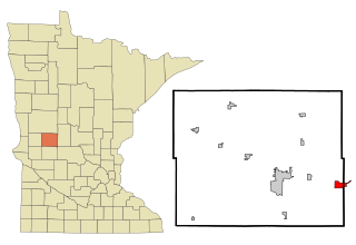
Osakis is a city in Douglas and Todd counties in the U.S. state of Minnesota. The population was 1,771 at the 2020 census.

References

  1. "ArcGIS REST Services Directory". United States Census Bureau. Retrieved October 15, 2022.
  2. 1 2 U.S. Geological Survey Geographic Names Information System: McConnells, South Carolina
  3. 1 2 "Census Population API". United States Census Bureau. Retrieved October 15, 2022.
  4. 1 2 "U.S. Census website". United States Census Bureau . Retrieved January 31, 2008.
  5. "National Register Information System". National Register of Historic Places . National Park Service. July 9, 2010.
  6. "US Gazetteer files: 2010, 2000, and 1990". United States Census Bureau. February 12, 2011. Retrieved April 23, 2011.
  7. "Census of Population and Housing". Census.gov. Retrieved June 4, 2015.