Rison, Arkansas

Last updated

Rison, Arkansas
City of Rison
Cleveland County Arkansas Courthouse.jpg
Cleveland County Courthouse in Rison - listed on National Register of Historic Places
Cleveland County Arkansas Incorporated and Unincorporated areas Rison Highlighted 0559480.svg
Location in Cleveland County and Arkansas
Usa edcp relief location map.png
Red pog.svg
Rison
Location in the United States
Coordinates: 33°57′36″N92°11′37″W / 33.96000°N 92.19361°W / 33.96000; -92.19361
Country Flag of the United States.svg  United States
State Flag of Arkansas.svg  Arkansas
County Cleveland
FoundedNovember 1, 1883 (1883-11-01)
Incorporated August 26, 1890 (1890-08-26)
Founded by Samuel Fordyce
Named for William Rison
Government
  Type Mayor–Council
   Mayor (I)
   Council City Council
Area
[1]
  Total3.27 sq mi (8.48 km2)
  Land3.27 sq mi (8.48 km2)
  Water0.00 sq mi (0.00 km2)
Elevation
[2]
230 ft (70 m)
Population
 (2020)
  Total967
  Density295.27/sq mi (113.99/km2)
Time zone UTC−06:00 (Central (CST))
  Summer (DST) UTC−05:00 (CDT)
ZIP Code
71665
Area code 870
FIPS code 05-59480
GNIS feature ID2404622 [2]

Rison, officially the City of Rison, is a city in and the county seat of Cleveland County, [3] Arkansas, United States. Its population was 1,344 at the 2010 U.S. census. [4] It is included in the Pine Bluff, Arkansas Metropolitan Statistical Area. Rison is a bedroom community for people who work in Pine Bluff (in neighboring Jefferson County). The largest employers are the city and county governments, the Cleveland County School District, the Cleveland County Nursing Home. There are two banks, eight churches, and about forty-five businesses within the city limits. Among the local properties listed on the National Register of Historic Places are the Rison Cities Service Station and the Rison Texaco Service Station. [5]

Contents

History

The Texas and St. Louis Railroad gave rise to Rison. The county seat of Dorsey County (present day Cleveland County) was originally Toledo. When the railroad was routed through the county in 1882, Rison did not exist. Samuel Fordyce of Huntsville, Alabama, a former Union army officer, was authorized to determine the route of the railroad from Texarkana to Birds Point, Missouri. According to unsubstantiated legend, when the leading citizens of Toledo snubbed his plans to route the railroad through that community, Fordyce planned a route three miles north and built a station through land that would later become Rison.

Fordyce named the new station for William Rison, his former business partner in a banking venture in Alabama, who had fought on the opposite side of the Civil War. The first home erected in the community the small settlement that grew up around the new station was built in 1880 by lawyer and farmer James McMurtrey. In 1883, the Southwest Improvement Association, a subsidiary of the railroad company, presented a parcel of land for use by the inhabitants of the area that became Rison. The settlement was incorporated on August 26, 1890, with J. T. Renfrow as mayor. The name of the county was changed from Dorsey to Cleveland in 1885; the popularity of U.S. Senator Stephen Dorsey had waned, and President Grover Cleveland's name was substituted. The Arkansas Supreme Court relocated the county seat from Toledo to Rison in 1891 after a spirited battle among the leading contenders, Toledo, Kingsland, and Rison.

The railroad remained Rison's point of reference for decades. “Rison on the Cotton Belt” was the affectionate way residents referred to their community. The commercial value of the railroad was felt from the beginning. The economy depended on the production of cotton, lumber, and, ultimately, a wide variety of wood products, including pulpwood, piling, pallets, broom handle squares, ammunition boxes, and Army pup tent poles.

The financial make-up of the community was divided for several decades into owners and sharecroppers. The emergence of the timber-related wood products business ultimately skewed that economic picture, with the corresponding rise of the merchant entrepreneurs also affecting it somewhat. Nevertheless, family fortunes were built on the owner/sharecropper system, and they influenced the financial and social structure of the town. Sharecropping was the prevailing structure of the primary business enterprise in the county until the land became depleted by failure to rotate crops adequately.

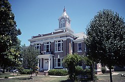
The Cleveland County Courthouse was built in 1911 after two contested elections. Two years later, the Phoenix Hotel was built and served as a popular gathering spot for the local community.

Three cotton gins operated in and around Rison. The largest and most efficient gin was owned by Ira E. Moore. That gin was built in 1933 to replace one owned by Moore that was built in 1926 and burned in 1933. The more modern and efficient all-electric gin built in 1933 was the first of its kind in the area.

Residents of Rison owned and operated a dozen or more sawmills. The largest lumber mills were the J. I. Porter Lumber Company and the Clio Lumber Company. The Clio mill was built in 1887 five miles north of Rison. According to a 1909 issue of Lumberman's Magazine, the Clio mill owned several thousand acres of timberland and had 432 employees in the sawmill, 130 on the woods crew, and eighty operating the tramlines that transported the logs to the mill. Other mills that added significantly to the economy were the J. L. Sadler Lumber Company, the C. L. Garner & Sons Lumber Company, and the Elrod Lumber Company. In the 1950s, Elrod employed about one-third of Rison's population, more than 300.

During World War II, many Rison residents secured war-related jobs in nearby towns. These included the Pine Bluff Arsenal (Jefferson County) and the Naval Ammunition Depot at Camden (Ouachita County). Others went to California to work in the shipbuilding industry. The Rison high school's football program was suspended until the end of the war due to a lack of players and coaches, as well as financial constraints. One of Rison's citizens, Airman Roy Martin, was shot down over occupied France and classified as missing in action. The French underground secured his freedom by hiding him in attics, barns, and other places not known to the German occupying forces. When the news of Martin's survival reached Rison, a wild celebration broke out in streets and homes. [5]

Geography

Rison is located in north-central Cleveland County. U.S. Route 79 passes through the western side of the city, leading northeast 25 miles (40 km) to Pine Bluff and southwest 17 miles (27 km) to Fordyce.

According to the United States Census Bureau, the city has a total area of 2.6 square miles (6.8 km2), all land. [4]

Demographics

Historical population
CensusPop.Note
1900 453
1910 72560.0%
1920 685−5.5%
1930 87627.9%
1940 1,00514.7%
1950 953−5.2%
1960 889−6.7%
1970 1,21436.6%
1980 1,3259.1%
1990 1,258−5.1%
2000 1,2711.0%
2010 1,3445.7%
2020 967−28.1%
U.S. Decennial Census [6]

2020 census

Rison racial composition [7]
RaceNumberPercentage
White (non-Hispanic)54055.84%
Black or African American (non-Hispanic)33234.33%
Native American 40.41%
Other/Mixed 424.34%
Hispanic or Latino 495.07%

As of the 2020 United States census, there were 967 people, 498 households, and 297 families residing in the city.

2000 census

As of the census [8] of 2000, there were 1,271 people, 471 households, and 324 families residing in the city. The population density was 475.1 inhabitants per square mile (183.4/km2). There were 532 housing units at an average density of 198.9 per square mile (76.8/km2). The racial makeup of the city was 62.23% White, 33.36% Black or African American, 0.31% Native American, 0.24% Asian, 1.73% from other races, and 2.12% from two or more races. 2.20% of the population were Hispanic or Latino of any race.

There were 471 households, out of which 36.3% had children under the age of 18 living with them, 45.0% were married couples living together, 19.1% had a female householder with no husband present, and 31.2% were non-families. 30.1% of all households were made up of individuals, and 15.3% had someone living alone who was 65 years of age or older. The average household size was 2.55 and the average family size was 3.16.

In the city, the population was spread out, with 29.3% under the age of 18, 6.8% from 18 to 24, 25.3% from 25 to 44, 19.6% from 45 to 64, and 19.0% who were 65 years of age or older. The median age was 36 years. For every 100 females, there were 79.8 males. For every 100 females age 18 and over, there were 75.2 males.

The median income for a household in the city was $20,865, and the median income for a family was $30,833. Males had a median income of $26,500 versus $18,229 for females. The per capita income for the city was $13,106. About 25.6% of families and 32.9% of the population were below the poverty line, including 46.0% of those under age 18 and 30.5% of those age 65 or over.

Education

Public education for early childhood, elementary and secondary school students in the city limits of Rison is provided by the Cleveland County School District, which is headquartered in Rison. Students graduate from Rison High School. [9] The district was established by the July 1, 2004, consolidation of the Rison School District and the Kingsland School District. [10]

Notable people

Related Research Articles

<span class="mw-page-title-main">Houston County, Texas</span> County in Texas, United States

Houston County is a county located in the U.S. state of Texas. As of the 2020 census, its population was 22,066. Its county seat is Crockett. Houston County was one of 46 entirely dry counties in the state of Texas, until voters in a November 2007 special election legalized the sale of alcohol in the county.

<span class="mw-page-title-main">Jefferson County, Arkansas</span> County in Arkansas, United States

Jefferson County, Arkansas is a county located in the U.S. state of Arkansas in the area known as the Arkansas Delta that extends west of the Mississippi River. Jefferson County consists of five cities, two towns, and 20 townships. It is bisected by the Arkansas River, which was critical to its development and long the chief transportation byway. In 2020, Jefferson County's population was estimated at 67,260. The county seat and largest city is Pine Bluff. The county is included in the Pine Bluff metropolitan statistical area. The county seat and the most populous city is Pine Bluff.

<span class="mw-page-title-main">Cleveland County, Arkansas</span> County in Arkansas, United States

Cleveland County is a county located in the U.S. state of Arkansas. Its population was 7,550 at the 2020 U.S. census. The county seat and largest city is Rison.

<span class="mw-page-title-main">Bradley County, Arkansas</span> County in Arkansas, United States

Bradley County is a county located in the U.S. state of Arkansas. As of the 2020 census, the population was 10,545. The county seat is Warren. It is Arkansas's 43rd county, formed on December 18, 1840, and named for Captain Hugh Bradley, who fought in the War of 1812.

<span class="mw-page-title-main">Crossett, Arkansas</span> Tonia Braxton

Crossett is the largest city in Ashley County, Arkansas, United States, with a population of 5,507, according to 2010 Census Bureau estimates. Combined with North Crossett and West Crossett, the population is 10,752. Crossett was incorporated in 1903.

<span class="mw-page-title-main">Hermitage, Arkansas</span> City in Arkansas, United States

Hermitage is a city in Bradley County, Arkansas, United States. The United States Census Bureau estimated the population to be 830 as of the 2010 census.

<span class="mw-page-title-main">Warren, Arkansas</span> City in Arkansas, United States

Warren is a city in and the county seat of Bradley County, Arkansas, United States. As of the 2010 census, the population was 6,003.

<span class="mw-page-title-main">Kingsland, Arkansas</span> City in Arkansas, United States

Kingsland, officially the City of Kingsland, is a small city in Cleveland County, south central Arkansas, United States. It is included in the Pine Bluff, Arkansas Metropolitan Statistical Area, and had a population of 447 at the 2010 U.S. census. It is known as the birthplace of musician Johnny Cash. His parents had a cotton farm there.

<span class="mw-page-title-main">Fordyce, Arkansas</span> City in Arkansas, United States

Fordyce is a city in southeast Dallas County, Arkansas, United States. Its population has been decreasing since the 1980s when the town reached an all time high of 5,175. The population in 2020 was 3,396 down from 4,300 at the 2010 census, and from 4,799 in 2000.

<span class="mw-page-title-main">McGehee, Arkansas</span> City in Arkansas, United States

McGeheemə-GHEE is a city in Desha County, Arkansas, United States. The population was 4,219 at the 2010 census.

<span class="mw-page-title-main">Mountain Pine, Arkansas</span> City in Arkansas, United States

Mountain Pine is a city in Garland County, Arkansas, United States. It is part of the Hot Springs Metropolitan Statistical Area. The population was 770 at the 2010 United States Census. It is located immediately southeast of Lake Ouachita below the Blakely Mountain Dam. The city consists of five defined neighborhoods, Pinewood (north), South Mountain Pine, a business district, Cozy Acres (southwest) and Mountain View/Timberland area.

<span class="mw-page-title-main">Pine Bluff, Arkansas</span> City in Arkansas, United States

Pine Bluff is the 10th most populous city in the US state of Arkansas and the county seat of Jefferson County. It is the principal city of the Pine Bluff Metropolitan Statistical Area and part of the Little Rock-North Little Rock-Pine Bluff Combined Statistical Area. The population of the city was 41,253 in the 2020 census.

<span class="mw-page-title-main">White Hall, Arkansas</span> City in Arkansas, United States

White Hall is a city in Washington Township, located in Jefferson County, Arkansas, United States. With a population of 5,526 in the 2010 census, it is included in the Pine Bluff Metropolitan Statistical Area and the greater Little Rock-North Little Rock-Pine Bluff Combined Statistical Area. White Hall is home to the Pine Bluff Arsenal.

<span class="mw-page-title-main">Star City, Arkansas</span> City in Arkansas, United States

Star City is a city in, and the county seat of, Lincoln County, Arkansas, United States. Incorporated in 1876, the city is located between the Arkansas Delta and Arkansas Timberlands. With an economy historically based on agriculture, today Star City has developed a diverse economy based on both industry and agriculture. As of the 2010 census, the population was 2,274. Star City is located within the Pine Bluff metropolitan area.

<span class="mw-page-title-main">Willow River, Minnesota</span> City in Minnesota, United States

Willow River is a city in Pine County, Minnesota, United States, at the confluence of the Kettle and Willow Rivers. The population was 415 at the 2010 census.

<span class="mw-page-title-main">Heavener, Oklahoma</span> City in Oklahoma, United States

Heavener is a town in Le Flore County, Oklahoma, United States. The population was 3,414 at the 2010 census, an increase of 6.7 percent from 3,201 at the 2000 census. Heavener is notable for the Heavener Runestone just outside the city limits.

<span class="mw-page-title-main">Valliant, Oklahoma</span> Town in Oklahoma, United States

Valliant is a town in McCurtain County, Oklahoma, United States. The population was 754 at the 2010 census.

<span class="mw-page-title-main">Gore, Oklahoma</span> Town in Oklahoma, United States

Gore is a town in western Sequoyah County, Oklahoma, United States. It is part of the Fort Smith, Arkansas-Oklahoma Metropolitan Statistical Area. The population was 977 at the 2010 census, an increase of 15 percent over the figure of 850 recorded in 2000.

<span class="mw-page-title-main">Sallisaw, Oklahoma</span> City in Oklahoma, United States

Sallisaw is a city and county seat in Sequoyah County, Oklahoma, United States. As of the 2010 Census, it had a population of 8,880, an 11.2 percent increase over the figure of 7,891 recorded in 2000. Sallisaw is part of the Fort Smith, Arkansas–Oklahoma Metropolitan Statistical Area.

<span class="mw-page-title-main">New Edinburg, Arkansas</span> Census-designated place in Arkansas, United States

New Edinburg is an unincorporated census-designated place in Cleveland County, Arkansas, United States. Per the 2020 census, the population was 134.

References

  1. "2020 U.S. Gazetteer Files". United States Census Bureau. Retrieved October 29, 2021.
  2. 1 2 U.S. Geological Survey Geographic Names Information System: Rison, Arkansas
  3. "Find a County". National Association of Counties. Retrieved June 7, 2011.
  4. 1 2 "Geographic Identifiers: 2010 Demographic Profile Data (G001): Rison city, Arkansas". U.S. Census Bureau, American Factfinder. Archived from the original on February 12, 2020. Retrieved June 17, 2014.
  5. 1 2 "Encyclopedia of Arkansas". Encyclopedia of Arkansas. Retrieved September 15, 2020.
  6. "Census of Population and Housing". Census.gov. Retrieved June 4, 2015.
  7. "Explore Census Data". data.census.gov. Retrieved December 30, 2021.
  8. "U.S. Census website". United States Census Bureau . Retrieved January 31, 2008.
  9. "SCHOOL DISTRICT REFERENCE MAP (2010 CENSUS): Cleveland County, AR." U.S. Census Bureau. Retrieved on October 15, 2017.
  10. "ConsolidationAnnex_from_1983.xls Archived 2015-09-12 at the Wayback Machine ." Arkansas Department of Education. Retrieved on October 13, 2017.