Yellville, Arkansas

Last updated

Yellville, Arkansas
Marion County Courthouse, Yellville, Arkansas.JPG
Marion County Courthouse in downtown Yellville
City of Yellville Logo.png
Marion County Arkansas Incorporated and Unincorporated areas Yellville Highlighted 0577330.svg
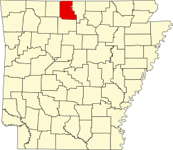
Location in Marion County, Arkansas
Coordinates: 36°13′44″N92°41′10″W / 36.22889°N 92.68611°W / 36.22889; -92.68611
Country United States
State Arkansas
County Marion
Government
  Type Mayor–council
  MayorShawn Lane [1]
Area
[2]
  Total2.51 sq mi (6.49 km2)
  Land2.48 sq mi (6.43 km2)
  Water0.02 sq mi (0.06 km2)
Elevation
[3]
627 ft (191 m)
Population
 (2020) [4]
  Total1,178
  Density474.62/sq mi (183.25/km2)
Time zone UTC-6 (Central (CST))
  Summer (DST) UTC-5 (CDT)
ZIP code
72687
Area code 870
FIPS code 05-77330
GNIS feature ID2405799 [3]
Website www.yellvilleweb.com

Yellville is a city in and county seat of Marion County, Arkansas, United States. [5] Yellville is located in the Ozark Mountains along the banks of Crooked Creek, and neighbors the small town of Summit to the north. The population was 1,178 at the 2020 census. [4] The town's original name is preserved in the Shawnee Town Branch, a local creek. The town holds an annual Turkey Trot Festival (turkey trot).

Contents

History

Yellville is named after Archibald Yell, who was the first member of the United States House of Representatives from Arkansas and the second governor of Arkansas. [6] He was killed at the Battle of Buena Vista during the Mexican–American War. Yellville existed well before Arkansas became a state, though originally known as "Shawneetown".

Marion County was formed in 1836, shortly after statehood. Shawneetown was then renamed Yellville. An old tale claims Archibald Yell offered $50 to do so, but never paid the money. True or not, Governor Yell's descendants heard the story and paid the overdue "bill" several years ago. Yell's name can be seen elsewhere in the state, including Yell County and Archibald Yell Boulevard in Fayetteville. Several biographies of him have been written, the most recent published by the University of Arkansas Press in Fayetteville.

During the late 1840s, Yellville was the scene of several prolonged gunfights during the Tutt–Everett War. John A. Schnabel organized his Confederate cavalry battalion in the town in 1863.

Geography

Yellville is located in central Marion County. According to the United States Census Bureau, the city has a total area of 2.5 square miles (6.5 km2), of which 0.02 square miles (0.05 km2), or 0.96%, are water. [2] It is bordered to the north by the small city of Summit. Mountain Home is 20 miles (32 km) to the northeast and Harrison is 28 miles (45 km) to the west via U.S. Routes 412/62.

Climate

Yellville, located in the Arkansas Ozarks, has a humid continental-subtropical climate, with cold-to-mild winters and hot, humid summers. Yellville's record high temperature of 110 °F (43 °C) was observed on August 29, 1984, and July 30, 1986, while the record low of −20 °F (−29 °C) was observed on January 11, 1977.

Climate data for Yellville, Arkansas
MonthJanFebMarAprMayJunJulAugSepOctNovDecYear
Record high °F (°C)76
(24)
83
(28)
92
(33)
95
(35)
94
(34)
102
(39)
110
(43)
110
(43)
102
(39)
95
(35)
85
(29)
78
(26)
110
(43)
Mean daily maximum °F (°C)48
(9)
53
(12)
63
(17)
73
(23)
80
(27)
87
(31)
92
(33)
91
(33)
83
(28)
74
(23)
62
(17)
51
(11)
71
(22)
Mean daily minimum °F (°C)21
(−6)
26
(−3)
35
(2)
44
(7)
52
(11)
61
(16)
65
(18)
63
(17)
56
(13)
43
(6)
35
(2)
26
(−3)
44
(7)
Record low °F (°C)−20
(−29)
−14
(−26)
2
(−17)
18
(−8)
30
(−1)
40
(4)
44
(7)
38
(3)
29
(−2)
18
(−8)
2
(−17)
−15
(−26)
−20
(−29)
Average precipitation inches (mm)2.40
(61)
2.90
(74)
4.40
(112)
4.20
(107)
5.20
(132)
4.10
(104)
2.80
(71)
3.50
(89)
3.90
(99)
3.70
(94)
4.50
(114)
3.90
(99)
45.50
(1,156)
Average snowfall inches (cm)3.8
(9.7)
3.4
(8.6)
2.2
(5.6)
0.2
(0.51)
0
(0)
0
(0)
0
(0)
0
(0)
0
(0)
0
(0)
0.9
(2.3)
2.8
(7.1)
13.3
(34)
Source: [7]

Demographics

Historical population
CensusPop.Note
1860 170
1870 96−43.5%
1880 345259.4%
1890 263−23.8%
1900 578119.8%
1910 463−19.9%
1920 61532.8%
1930 478−22.3%
1940 54614.2%
1950 69727.7%
1960 636−8.8%
1970 86035.2%
1980 1,04421.4%
1990 1,18113.1%
2000 1,31211.1%
2010 1,204−8.2%
2020 1,178−2.2%
U.S. Decennial Census [8]

2020 census

Yellville racial composition [9]
RaceNumberPercentage
White (non-Hispanic)1,05989.9%
Native American 131.1%
Asian 60.51%
Other/Mixed 675.69%
Hispanic or Latino 332.8%

As of the 2020 United States census, there were 1,178 people, 416 households, and 271 families residing in the city.

2000 census

As of the census [10] of 2000, there were 1,312 people, 535 households, and 356 families residing in the city. The population density was 515.6 inhabitants per square mile (199.1/km2). There were 599 housing units at an average density of 235.4 per square mile (90.9/km2). The racial makeup of the city was 97.71% White, 0.76% Native American, 0.23% Asian, 0.08% Pacific Islander, and 1.22% from two or more races. 0.53% of the population were Hispanic or Latino of any race.

There were 535 households, out of which 30.7% had children under the age of 18 living with them, 48.8% were married couples living together, 15.0% had a female householder with no husband present, and 33.3% were non-families. 30.3% of all households were made up of individuals, and 18.3% had someone living alone who was 65 years of age or older. The average household size was 2.31 and the average family size was 2.84.

In the city, the population was spread out, with 24.2% under the age of 18, 9.0% from 18 to 24, 22.3% from 25 to 44, 22.3% from 45 to 64, and 22.3% who were 65 years of age or older. The median age was 41 years. For every 100 females, there were 83.8 males. For every 100 females age 18 and over, there were 79.6 males.

The median income for a household in the city was $26,250, and the median income for a family was $31,793. Males had a median income of $26,000 versus $18,056 for females. The per capita income for the city was $12,618. About 13.2% of families and 17.7% of the population were below the poverty line, including 22.2% of those under age 18 and 13.8% of those age 65 or over.

Human resources

Education

Primary and secondary education

Public education for early childhood, elementary and secondary school students is provided by the Yellville–Summit School District, which leads to graduation from Yellville–Summit High School.

Higher education

In 1890, Yellville College was established in the city along College Street. The institution was demolished in 1925. Today, neither Yellville nor Marion County contain any institutions of higher education. The nearest are Arkansas State University Mountain Home, in Mountain Home, and North Arkansas College in Harrison, both two-year public schools. Nearby four-year education is offered by College of the Ozarks, a Christian liberal-arts college in Point Lookout, Missouri, and Lyon College, a private liberal arts college in Batesville. The nearest four-year public school is Arkansas Tech University in Russellville.

Library system

The Marion County Library is located at 308 Old Main in Yellville. [11] The library offers books, e-books, media, reference, youth, and genealogy services.

Public safety

Yellville and Marion County operate under a joint city/county law enforcement agreement.

Culture and contemporary life

Buffalo National River

Yellville is popular for its proximity to the Buffalo National River, 16 miles (26 km) to the south via State Highway 14. During the summer, tourists visit the area and Yellville becomes a hub for shopping and lodging for them. The Buffalo Point Ranger Station is located approximately 17 miles (27 km) south of Yellville. Activities and services in the area include horseback trail riding, canoeing, and cabin rentals. Other area attractions include the more than 1,000 caves that exist in Marion County, and the famous "Rush" ghost town located in the Buffalo Point area—a turn-of-the-century ghost town from the zinc mining heyday of the area. Abandoned mines are visible along many of the hiking trails at Rush, but are fenced off due to safety concerns. Recent arson has destroyed a few of the historic buildings of the Rush ghost town.

Bull Shoals Dam and Reservoir / White River

Most of northern Marion County is made up of water—most notably, the waters created by the Bull Shoals Dam. Eastern Marion County's border with Baxter County is marked by the White River. Water skiing, pontoon boating, and fishing are all popular summer activities at the Bull Shoals Lake and White River areas. Yellville is located approximately 15 miles (24 km) southwest of Bull Shoals and serves as an alternate housing and tourist destination for those not staying at the numerous resorts in Bull Shoals, along the White River, or at the confluence of the Buffalo and White rivers near Buffalo City.

Fred Berry Conservation Education Center on Crooked Creek

Crooked Creek near the City Park Yellville, AR 022.jpg
Crooked Creek near the City Park

In 1999, Fred Berry, a former counselor and teacher at the Yellville-Summit School District, donated the funding to create an educational center at Kelley's Access on Crooked Creek, located near the Yellville City Park. With additional donations and a "conservation tax", the plan was put into action. On June 17, 2005, the Fred Berry Conservation Education Center on Crooked Creek opened. It is one of four education centers with the Arkansas Game and Fish Commission. It sits on 471 acres (1.91 km2) of land along a 2.5-mile (4.0 km) stretch of Crooked Creek that was once a dairy farm.

Annual cultural events

One of the longest traditions in Yellville is the annual Turkey Trot festival sponsored by the Mid-Marion County Rotary Club. Beginning in 1945 with the first turkey dropped from the roof of the Marion County Courthouse, the festival continues today. It is held every second weekend of October with the best-known attraction being live turkeys that are dropped from airplanes over the town square. [12] The event has been criticized in the past by People for the Ethical Treatment of Animals and others. The Turkey Trot festival also includes a pageant, dinners, musical entertainment, a 5 kilometer run, a parade, and a nationally recognized turkey calling contest sponsored by the National Wild Turkey Federation. Crafts and tools related to the hunting of wild turkeys are also sold in streetside booths along the town square. [13]

Infrastructure

Major highways

Highway 14 in Yellville Yellville, AR 019.jpg
Highway 14 in Yellville

Utilities

Entergy Arkansas is the sole provider of electricity in almost all of Marion County, including Yellville. [14] Natural gas service is available from Black Hills Energy. Sanitation is provided by Nabors Sanitation, and cable television service is provided by Yelcot

The Yellville Water Department purchases potable water from the Marion County Regional Water Association, whose source is Bull Shoals Lake. [15] The Yellville Water Department has 2,329 retail population served, and is responsible for maintenance of the water system and customer billing. [16]

Notable people

Related Research Articles

<span class="mw-page-title-main">Newton County, Missouri</span> County in Missouri, United States

Newton County is a county located in the southwest portion of the U.S. state of Missouri. As of the 2020 census, the population was 58,648. Its county seat is Neosho. The county was organized in 1838 and is named in honor of John Newton, a hero who fought in the Revolutionary War.

<span class="mw-page-title-main">Marion County, Arkansas</span> County in Arkansas, United States

Marion County is located in the Ozark Mountains in the U.S. state of Arkansas. The county is named for Francis Marion, the famous "Swamp Fox" of the Revolutionary War. Created as Arkansas's 35th county in 1836, Marion County is home to one incorporated town and four incorporated cities, including Yellville, the county seat. The county is also the site of numerous unincorporated communities and ghost towns. The county included part of what is now Searcy County, Arkansas, with many opposing to dividing them, which helped fueled the bloody Tutt-Everett War between 1844 and 1850.

<span class="mw-page-title-main">Logan County, Arkansas</span> County in Arkansas, United States

Logan County is a county located in the U.S. state of Arkansas. As of the 2020 census, the population was 21,131. Its two county seats are Booneville and Paris.

<span class="mw-page-title-main">Cleburne County, Arkansas</span> County in Arkansas, United States

Cleburne County is a county located in the U.S. state of Arkansas. As of the 2020 census, the population was 24,711. The county seat and most populous city is Heber Springs. The county was formed on February 20, 1883, as the last of Arkansas's 75 counties to be formed. It is named for Confederate Major-General Patrick Cleburne. Cleburne is an alcohol prohibition or dry county.

<span class="mw-page-title-main">Boone County, Arkansas</span> County in Arkansas, United States

Boone County is located in the U.S. state of Arkansas, along the Missouri border. As of the 2020 census, the population was 37,373. The county seat is Harrison. It is Arkansas's 62nd county, formed on April 9, 1869.

<span class="mw-page-title-main">Baxter County, Arkansas</span> County in Arkansas, United States

Baxter County is a county in the U.S. state of Arkansas. As of the 2020 census, the county's population was 41,627. The county seat is Mountain Home. It is Arkansas's 66th county, formed on March 24, 1873, and named for Elisha Baxter, the tenth governor of Arkansas.

<span class="mw-page-title-main">Mountain Home, Arkansas</span> City in Arkansas, United States

Mountain Home is a city in and the county seat of Baxter County, Arkansas, United States, in the southern Ozark Mountains near the northern state border with Missouri. As of the 2010 census, the city had a population of 12,448. A total of 41,307 persons lived within the city and micropolitan area combined, which encompasses the majority of Baxter County.

<span class="mw-page-title-main">Diamond City, Arkansas</span> City in Arkansas, United States

Diamond City is a city in northeast Boone County, Arkansas, United States. The population was 782 at the 2010 census. It is part of the Harrison Micropolitan Statistical Area.

<span class="mw-page-title-main">Harrison, Arkansas</span> City in Arkansas, United States

The city of Harrison is the county seat of Boone County, Arkansas, United States. It is named after Marcus LaRue Harrison, a surveyor who laid out the city along Crooked Creek at Stifler Springs. According to 2019 Census Bureau estimates, the population of the city was 13,069, up from 12,943 at the 2010 census and it is the 30th largest city in Arkansas based on official 2019 estimates from the U.S. Census Bureau. Harrison is the principal city of the Harrison Micropolitan Statistical Area, which includes all of Boone and Newton counties.

<span class="mw-page-title-main">Lead Hill, Arkansas</span> Town in Arkansas, United States

Lead Hill is a town in Boone County, Arkansas, United States. The population was 271 at the 2010 census. It is part of the Harrison Micropolitan Statistical Area.

<span class="mw-page-title-main">Bull Shoals, Arkansas</span> City in Arkansas, United States

Bull Shoals is a city in Marion County, Arkansas, United States, founded in 1954. The population was 1,952 at the 2020 census. Primarily a retirement and vacation center, Bull Shoals is bordered in three directions by the clear, deep, man-made Bull Shoals Lake.

<span class="mw-page-title-main">Flippin, Arkansas</span> City in Arkansas, United States

Flippin is a city in Marion County, Arkansas, United States. The population was 1,345 at the 2020 census.

<span class="mw-page-title-main">Pyatt, Arkansas</span> Town in Arkansas, United States

Pyatt is a town in western Marion County, Arkansas, United States. The population was 181 at the 2020 census, down from 221 in 2010.

<span class="mw-page-title-main">Summit, Arkansas</span> City in Arkansas, United States

Summit is a city in Marion County, Arkansas, United States. The population was 544 at the 2020 census, down from 604 in 2010.

<span class="mw-page-title-main">Danville, Arkansas</span> City in Arkansas, United States

Danville is a city in Yell County, Arkansas, United States. The population was 2,409 at the 2010 census. Along with Dardanelle, it is one of two county seats for Yell County.

<span class="mw-page-title-main">Dardanelle, Arkansas</span> City in Arkansas, United States

Dardanelle is a city in northeast Yell County, Arkansas, United States. The population was 4,517 at the 2020 census. Along with Danville, it serves as a county seat for Yell County. It is located near Lake Dardanelle.

<span class="mw-page-title-main">Havana, Arkansas</span> City in Arkansas, United States

Havana is a city in northwest Yell County, Arkansas, United States. The population was 375 at the 2010 census. It is part of the Russellville Micropolitan Statistical Area. Arkansas Scenic State Highway 309 leads from Havana to the top of Mount Magazine, home of Arkansas's newest State Park, and the highest peak in Arkansas.

<span class="mw-page-title-main">Marble Hill, Missouri</span> City in Missouri, United States

Marble Hill is a fourth-class city in central Bollinger County in Southeast Missouri, United States. Located at the intersection of State Highways 34 and 51, it is the largest city in Bollinger and serves as the county seat. The population was 1,388 at the 2020 census. The city was officially organized in July 1851 and is named after a marble-like rock.

<span class="mw-page-title-main">Arkansas Highway 202</span> State highway in Arkansas, United States

Arkansas Highway 202 is a designation for two east–west state highway in Arkansas. One segment runs 7.38 miles (11.88 km) from US 62/US 412 in Yellville east to Highway 178. A second portion runs 9.63 miles (15.50 km) from Bull Shoals Lake east to Arkansas Highway 5 in Baxter County. Both routes are maintained by the Arkansas State Highway and Transportation Department (AHTD).

<span class="mw-page-title-main">Arkansas Highway 14</span> Highway in Arkansas

Highway 14 is an east–west state highway in Arkansas. The route of 227.35 miles (365.88 km) begins at Boat Dock Road near Table Rock Lake and runs east to Mississippi County Route W1020 (CR W1020) at Golden Lake. Segments of the highway are part of two Arkansas Scenic Byways: Sylamore Scenic Byway in the Ozark National Forest and the Crowley's Ridge Parkway atop Crowley's Ridge.

References

  1. "Yellville". Little Rock: Arkansas Municipal League. 2019. Retrieved March 3, 2019.
  2. 1 2 "2021 U.S. Gazetteer Files: Arkansas". United States Census Bureau. Retrieved May 31, 2022.
  3. 1 2 U.S. Geological Survey Geographic Names Information System: Yellville, Arkansas
  4. 1 2 "P1. Race – Yellville city, Arkansas: 2020 DEC Redistricting Data (PL 94-171)". U.S. Census Bureau. Retrieved May 31, 2022.
  5. "Find a County". National Association of Counties. Retrieved June 7, 2011.
  6. Scriba, Jay (October 15, 1970). "From Sleepy Eye to Chicken Bristle, USA". The Milwaukee Journal . Archived from the original on September 25, 2015. Retrieved April 22, 2015.
  7. "Intellicast | Weather Underground". www.wunderground.com.
  8. "Census of Population and Housing". Census.gov. Retrieved June 4, 2015.
  9. "Explore Census Data". data.census.gov. Retrieved January 1, 2022.
  10. "U.S. Census website". United States Census Bureau . Retrieved January 31, 2008.
  11. "Marion County Libraries". Little Rock: Arkansas State Library . Retrieved March 3, 2019.
  12. Lowrry, Annie (November 20, 2018). "Tossing a Bird That Does Not Fly Out of a Plane: A Thanksgiving story about the limits of human empathy". The Atlantic . Retrieved November 21, 2018.
  13. "73rd Annual Turkey Trot Festival". The Mountaineer Echo . Flippin. October 11, 2018. Retrieved March 3, 2019.
  14. Electric Utility Service Territories (polygon) (Map) (Update ed.). Arkansas GIS Office. October 16, 2014 [June 5, 2009]. Retrieved March 3, 2019.
  15. "Yellville Waterworks Annual Drinking Water Quality Report" (PDF). Consumer Confidence Report. Little Rock: Arkansas Department of Health. 2017. Retrieved March 3, 2019.
  16. "Community Water System Data". Little Rock: Arkansas Department of Health, Engineering Section. Retrieved March 3, 2019.