Sandersville, Mississippi

Last updated

Sandersville, Mississippi
SandersvilleMississippiPostOffice.jpg
The U.S. Post Office in Sandersville, Mississippi
Jones County Mississippi Incorporated and Unincorporated areas Sandersville Highlighted.svg
Location of Sandersville, Mississippi
Usa edcp location map.svg
Red pog.svg
Sandersville, Mississippi
Location in the United States
Coordinates: 31°47′8″N89°2′4″W / 31.78556°N 89.03444°W / 31.78556; -89.03444
Country United States
State Mississippi
County Jones
Area
[1]
  Total4.99 sq mi (12.92 km2)
  Land4.95 sq mi (12.82 km2)
  Water0.04 sq mi (0.10 km2)
Elevation
276 ft (84 m)
Population
 (2020)
  Total636
  Density128.46/sq mi (49.60/km2)
Time zone UTC-6 (Central (CST))
  Summer (DST) UTC-5 (CDT)
ZIP code
39477
Area code 601
FIPS code 28-64920
GNIS feature ID0677364

Sandersville is a town in Jones County, Mississippi, United States. The population was 636 at the 2020 census, [2] down from 731 at the 2010 census. It is part of the Laurel micropolitan area.

Contents

History

Scottish settlers migrated here during the 1820s and built the Good Hope Presbyterian Church. In 1855, the town was named after the Sanders, a pioneer family.

Home construction was influenced by the Victorian era, as there are a noticeable number of cupolas on buildings in the town. [3]

Hunt Refining Company has a refinery northeast of Sandersville which processes crude oil acquired primarily from local Mississippi fields. The refinery produces distillate feedstock, paving grade asphalt, heavy gas oils, naphtha, and roofing grade asphalt. [4]

Geography

Sandersville is located in northeastern Jones County at 31°47′8″N89°2′4″W / 31.78556°N 89.03444°W / 31.78556; -89.03444 (31.785455, -89.034572). [5] U.S. Route 11 (Front Street) passes through the center of town, leading southwest 9 miles (14 km) to Laurel, the county's largest city, and northeast 10 miles (16 km) to Stafford Springs. Interstate 59 passes just west of the town limits, with access from Exit 104 (West Main Street). I-59 leads northeast 48 miles (77 km) to Meridian and southwest 39 miles (63 km) to Hattiesburg.

According to the United States Census Bureau, Sandersville has a total area of 5.0 square miles (12.9 km2), of which 0.04 square miles (0.1 km2), or 0.77%, is water. [2]

Demographics

Historical population
CensusPop.Note
1900 357
1910 60469.2%
1920 559−7.5%
1930 5651.1%
1940 562−0.5%
1950 68121.2%
1960 657−3.5%
1970 6945.6%
1980 80015.3%
1990 8536.6%
2000 789−7.5%
2010 731−7.4%
2020 636−13.0%
U.S. Decennial Census [6]
Sandersville racial composition as of 2020 [7]
(NH = Non-Hispanic) [lower-alpha 1]
RaceNumberPercentage
White (NH)53083.33%
Black or African American (NH)426.6%
Native American or Alaska Native (NH)294.56%
Asian (NH)10.16%
Mixed/Multi-Racial (NH)253.93%
Hispanic or Latino 91.42%
Total636

As of the 2020 United States census, there were 636 people, 268 households, and 218 families residing in the town.

As of the census [10] of 2000, there were 789 people, 317 households, and 231 families residing in the town. The population density was 159.2 inhabitants per square mile (61.5/km2). There were 350 housing units at an average density of 70.6 per square mile (27.3/km2). The racial makeup of the town was 92.14% White, 6.84% African American, 0.89% Native American, and 0.13% from two or more races. Hispanic or Latino of any race were 0.13% of the population.

There were 317 households, out of which 31.9% had children under the age of 18 living with them, 56.8% were married couples living together, 12.9% had a female householder with no husband present, and 27.1% were non-families. 23.3% of all households were made up of individuals, and 13.6% had someone living alone who was 65 years of age or older. The average household size was 2.49 and the average family size was 2.94.

In the town, the population was spread out, with 23.2% under the age of 18, 9.8% from 18 to 24, 28.1% from 25 to 44, 22.2% from 45 to 64, and 16.7% who were 65 years of age or older. The median age was 39 years. For every 100 females, there were 92.9 males. For every 100 females age 18 and over, there were 84.8 males.

The median income for a household in the town was $26,538, and the median income for a family was $34,167. Males had a median income of $27,614 versus $20,313 for females. The per capita income for the town was $14,429. About 12.8% of families and 16.2% of the population were below the poverty line, including 18.3% of those under age 18 and 28.9% of those age 65 or over.

Education

Sandersville is served by the Jones County School District.

Notable people

Related Research Articles

<span class="mw-page-title-main">Mound City, Illinois</span> City in Illinois, United States

Mound City is a city and the county seat of Pulaski County, Illinois, United States. It is located along the Ohio River just north of its confluence with the Mississippi River. As of the 2010 census, the city population was 588.

<span class="mw-page-title-main">Lynnville, Iowa</span> City in Iowa, United States

Lynnville is a city in Jasper County, Iowa, United States. The population was 380 at the time of the 2020 census.

<span class="mw-page-title-main">Gramercy, Louisiana</span> Town in Louisiana, United States

Gramercy is a town in the U.S. state of Louisiana, in St. James Parish. It is part of the New Orleans Metropolitan Area. The population was 3,613 at the time of the 2010 U.S. census and 3,188 according to the 2020 population estimates program.

<span class="mw-page-title-main">Hickory Flat, Mississippi</span> Town in Mississippi, United States

Hickory Flat is a town in Benton County, Mississippi, United States. The population was 601 at the 2010 census.

<span class="mw-page-title-main">Gunnison, Mississippi</span> Town in Mississippi, United States

Gunnison is a town in Bolivar County, Mississippi, United States. Per the 2020 census, the population was 295.

<span class="mw-page-title-main">North Carrollton, Mississippi</span> Town in Mississippi, United States

North Carrollton is a town in Carroll County, Mississippi, United States. The population was 473 at the 2010 census. It is part of the Greenwood, Mississippi micropolitan area.

<span class="mw-page-title-main">Cruger, Mississippi</span> Town in Mississippi, United States

Cruger is a town in Holmes County, Mississippi, United States. Per the 2020 census, the population was 268.

<span class="mw-page-title-main">Goodman, Mississippi</span> Town in Mississippi, United States

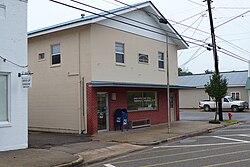
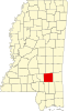
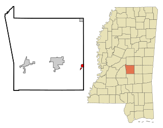
Goodman is a town in southeastern Holmes County, Mississippi, United States. Per the 2020 census, the population was 1,258.

<span class="mw-page-title-main">Pickens, Mississippi</span> Town in Mississippi, United States

Pickens is a town in Holmes County, Mississippi, United States. Per the 2020 census, the population was 920.

<span class="mw-page-title-main">West, Mississippi</span> Town in Mississippi, United States

West is a town in northeastern Holmes County, Mississippi, United States. Per the 2020 census, the population was 153. The Mayor of West, MS as of December 2020 is Michael Fancher.

<span class="mw-page-title-main">Redwater, Mississippi</span> Census-designated place in Mississippi, United States

Redwater is a census-designated place (CDP) in Leake County, Mississippi, United States. It is one of the eight communities of the Mississippi Band of Choctaw Indians Reservation, and the population is 61% Choctaw. The population was 633 at the 2010 census, up from 409 at the 2000 census.

<span class="mw-page-title-main">Falcon, Mississippi</span> Town in Mississippi, United States

Falcon is a town in Quitman County, Mississippi. The population was 116 at the 2020 census.

<span class="mw-page-title-main">Sledge, Mississippi</span> Town in Mississippi, United States

Sledge is a town located in Quitman County, Mississippi, United States. As of the 2020 census, the town had a total population of 368.

<span class="mw-page-title-main">Puckett, Mississippi</span> Village in Mississippi, United States

Puckett is a village in Rankin County, Mississippi, United States. According to the 2020 census, the population was 342. It is part of the Jackson Metropolitan Statistical Area.

<span class="mw-page-title-main">Lula, Mississippi</span> Town in Mississippi, United States

Lula is a town in Coahoma County, Mississippi, United States. Per the 2020 census, the population was 204.

<span class="mw-page-title-main">Pinhook, Missouri</span> Inactive Village in Missouri, United States

Pinhook is an inactive village in Mississippi County, Missouri, United States. The population was 6 at the 2020 census, down from 30 in 2010.

<span class="mw-page-title-main">Gallaway, Tennessee</span> City in Tennessee, United States

Gallaway is a city in Fayette County, Tennessee, United States. The population was 680 at the 2010 census.

<span class="mw-page-title-main">Wakefield, Virginia</span> Town in Virginia, United States

Wakefield is an incorporated town in Sussex County, Virginia, United States. Per the 2020 census, the population was 729.

Aurora is a town in Florence County, Wisconsin, United States. The population was 1,186 at the 2000 census. Aurora lies on the Michigan-Wisconsin border, across the Menominee River from Kingsford, Michigan.

<span class="mw-page-title-main">Lake, Mississippi</span> Town in Mississippi, United States

Lake is a town in Newton and Scott counties, Mississippi. The population was 408 at the 2000 census.

References

  1. Note: the US Census treats Hispanic/Latino as an ethnic category. This table excludes Latinos from the racial categories and assigns them to a separate category. Hispanics/Latinos can be of any race. [8] [9]
  1. "2020 U.S. Gazetteer Files". United States Census Bureau. Retrieved July 24, 2022.
  2. 1 2 "Geographic Identifiers: 2010 Census Summary File 1 (G001): Sandersville town, Mississippi". American Factfinder. U.S. Census Bureau. Archived from the original on February 13, 2020. Retrieved August 15, 2018.
  3. McElvaine, Robert S. (1988). Mississippi: The WPA Guide to the Magnolia State. University Press of Mississippi. ISBN   9781604732894.
  4. "Refining Operations". Hunt Refining Company. 2013. Archived from the original on February 27, 2013.
  5. "US Gazetteer files: 2010, 2000, and 1990". United States Census Bureau. February 12, 2011. Retrieved April 23, 2011.
  6. "Census of Population and Housing". Census.gov. Retrieved June 4, 2015.
  7. "Explore Census Data". data.census.gov. Retrieved June 7, 2022.
  8. https://www.census.gov/ [ not specific enough to verify ]
  9. "About the Hispanic Population and its Origin". www.census.gov. Retrieved May 18, 2022.
  10. "U.S. Census website". United States Census Bureau . Retrieved January 31, 2008.
  11. "Doug Satcher Stats". Pro-Football Reference. Retrieved June 26, 2022.
  12. Stribling, Will (July 3, 2019). "Shad White Bio". Mississippi Today. Retrieved June 26, 2022.