Hattiesburg–Laurel Regional Airport, nicknamed Airport City, is a public airport located in unincorporated Jones County, Mississippi.
Oak Grove is a census-designated place and unincorporated community located in Lamar County, Mississippi, United States. The settlement is a suburb located immediately west of Hattiesburg.

Valley Park is a census-designated place and unincorporated community in Issaquena County, Mississippi, United States. Its elevation is 95 feet. Although unincorporated, it has a post office, with the ZIP code of 39177.
Glen Allan is a census-designated place and unincorporated community located in far southern Washington County, Mississippi. It is situated immediately east of Lake Washington's southern shore.

Panther Burn is a census-designated place and unincorporated community located along U.S. Route 61 in northwestern Sharkey County, Mississippi, United States. It has a post office with the ZIP code of 38765.
Delta City is a census-designated place and unincorporated community located on Mississippi Highway 434 in Sharkey County, Mississippi. Delta City is approximately 6 miles (9.7 km) east of Panther Burn and approximately 5 miles (8.0 km) north of Nitta Yuma. Although an unincorporated community, Delta City has a zip code of 39061.
Ovett is a census-designated place and unincorporated community in southeastern Jones County, Mississippi. Ovett is part of the Laurel Micropolitan Statistical Area.

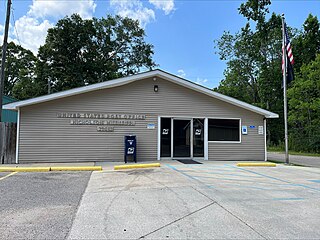
Eastabuchie is a census-designated place and unincorporated community in southwestern Jones County, Mississippi. It is located along U.S. Route 11, just north of the Forrest County line. the community has a post office with the ZIP code 39436. Eastabuchie is part of the Laurel Micropolitan Statistical Area.
Lamar is a census-designated place and unincorporated community in Benton County, Mississippi, United States. It is located along Mississippi Highway 7 in western Benton County. Lamar has a post office with the ZIP code 38642. The nearly abandoned Mississippi Central Railroad runs through Lamar, and is only used rarely for freight trafficking. Lamar shares its ZIP code with the nearby community of Slayden.
Grace is a census-designated place and unincorporated community in Issaquena County, Mississippi, United States. It is located several miles northeast of Mayersville.

Skene is a census-designated place and unincorporated community located in Bolivar County, Mississippi, United States on Mississippi Highway 446. Skene is approximately 3 miles (4.8 km) west of Boyle and approximately 7 miles (11 km) north of Shaw. Skene was a station on the Boyle and Sunflower branch of the former Yazoo and Mississippi Valley Railroad.
Longview is a census-designated place and unincorporated community located along Mississippi Highway 12 in Oktibbeha County, Mississippi. Longview is approximately 7 miles (11 km) southwest of Starkville and approximately 8 miles (13 km) northeast of Sturgis.
Mount Pleasant is a census-designated place and unincorporated community in northeastern Marshall County, Mississippi, United States, located along U.S. Route 72 at State Route 311. Although unincorporated, it has a post office serving the nearby city of Holly Springs. The zip code is 38649. The community also has a volunteer fire department located on Boswell Road, and a K-12 school located off of US Highway 72. Mount Pleasant is bordered by Cayce and Taska to the west, Holly Springs to the south, Slayden to the east, and Collierville, Tennessee to the north.
Paris is a census-designated place and unincorporated community in Lafayette County, Mississippi, United States. Paris is located at the junction of Mississippi Highway 9W and Mississippi Highway 315 10 miles (16 km) east of Water Valley.
Victoria is a census-designated place and unincorporated community in Marshall County, Mississippi, United States. Its ZIP code is 38679.
Nicholson is an unincorporated community and census-designated place (CDP) in Pearl River County, Mississippi, United States. As of the 2020 census, its population was 2,833. Its ZIP code is 39463.
Pattison, also known as Martin, is a census-designated place and unincorporated community in Claiborne County, Mississippi, United States. Its ZIP code is 39144.
Hillsboro is an unincorporated community and census-designated place (CDP) in Scott County, Mississippi, United States. Its population was 1,130 as of the 2010 census. Hillsboro has a post office with ZIP code 39087.

Glendale is an unincorporated community and census-designated place (CDP) located in Forrest County, Mississippi, United States. Glendale is approximately 3.5 miles (5.6 km) north of Hattiesburg on Mississippi Highway 42 and a part of the Hattiesburg, Mississippi Metropolitan Statistical Area.

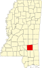
Sharon is an unincorporated community and census-designated place (CDP) in Jones County, Mississippi, United States. The population was 1,344 at the 2020 census. It is part of the Laurel micropolitan statistical area.