Eastabuchie, Mississippi

Last updated

Eastabuchie, Mississippi
Eastabuchie, Mississippi Post Office.jpg
Eastabuchie Post Office
USA Mississippi location map.svg
Red pog.svg
Eastabuchie
Usa edcp location map.svg
Red pog.svg
Eastabuchie
Coordinates: 31°26′08″N89°17′00″W / 31.43556°N 89.28333°W / 31.43556; -89.28333
Country United States
State Mississippi
County Jones
Area
[1]
  Total1.90 sq mi (4.91 km2)
  Land1.89 sq mi (4.89 km2)
  Water0.01 sq mi (0.02 km2)
Elevation
171 ft (52 m)
Population
 (2020)
  Total187
  Density99.10/sq mi (38.26/km2)
Time zone UTC-6 (Central (CST))
  Summer (DST) UTC-5 (CDT)
Area code 601
FIPS code 28-20740
GNIS feature ID669617

Eastabuchie is a census-designated place and unincorporated community in southwestern Jones County, Mississippi. [2] It is located along U.S. Route 11, just north of the Forrest County line. the community has a post office with the ZIP code 39436. [3] Eastabuchie is part of the Laurel Micropolitan Statistical Area.

Contents

History

The name Eastabuchie is derived from a native Choctaw language term for the Leaf River. [4]

Eastabuchie is located on the Norfolk Southern Railway and was incorporated on February 19, 1890. It was unincorporated at an unknown date. [5]

It was first named as a CDP in the 2020 Census which listed a population of 187. [6] The small, rural town is home to the studios of television station WDAM, the area's NBC and ABC affiliate.

In 1912, according to Frank Leslie's Weekly , several Confederate veterans lost their lives in a train wreck in Eastabuchie.

Demographics

Historical population
CensusPop.Note
2020 187
U.S. Decennial Census [7]
2020 [8]

2020 census

Eastabuchie CDP, Mississippi - Demographic Profile
(NH = Non-Hispanic)
Race / EthnicityPop 2020 [8] % 2020
White alone (NH)10656.68%
Black or African American alone (NH)7037.43%
Native American or Alaska Native alone (NH)10.53%
Asian alone (NH)00.00%
Pacific Islander alone (NH)00.00%
Some Other Race alone (NH)00.00%
Mixed Race/Multi-Racial (NH)21.07%
Hispanic or Latino (any race)84.28%
Total187100.00%

Note: the US Census treats Hispanic/Latino as an ethnic category. This table excludes Latinos from the racial categories and assigns them to a separate category. Hispanics/Latinos can be of any race.

Education

Public education in the Jones County section of Eastabuchie is provided by the Jones County School District. [9] Campuses serving the community include Moselle Elementary School (Grades K–6) and South Jones High School (Grades 7–12).

In Forrest County portions, it is served by the Petal School District. [10]

Notable people

Related Research Articles

Arkabutla is a census-designated place and unincorporated community in Tate County, Mississippi, United States. Arkabutla is located approximately 9 miles (14 km) west of Coldwater and approximately 9 miles (14 km) north of Strayhorn. It also lies approximately 4 miles (6.4 km) south of the dam at Arkabutla Lake. Although an unincorporated community, it has a post office and a zip code of 38602.

<span class="mw-page-title-main">Valley Park, Mississippi</span> Census-designated place in Mississippi, United States

Valley Park is a census-designated place and unincorporated community in Issaquena County, Mississippi, United States. Its elevation is 95 feet. Although unincorporated, it has a post office, with the ZIP code of 39177.

Glen Allan is a census-designated place and unincorporated community located in far southern Washington County, Mississippi. It is situated immediately east of Lake Washington's southern shore.

<span class="mw-page-title-main">Panther Burn, Mississippi</span> Census-designated place in Mississippi, United States

Panther Burn is a census-designated place and unincorporated community located along U.S. Route 61 in northwestern Sharkey County, Mississippi, United States. It has a post office with the ZIP code of 38765.

Delta City is a census-designated place and unincorporated community located on Mississippi Highway 434 in Sharkey County, Mississippi. Delta City is approximately 6 miles (9.7 km) east of Panther Burn and approximately 5 miles (8.0 km) north of Nitta Yuma. Although an unincorporated community, Delta City has a zip code of 39061.

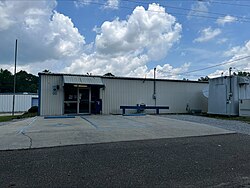
Ovett is a census-designated place and unincorporated community in southeastern Jones County, Mississippi. Ovett is part of the Laurel Micropolitan Statistical Area.

<span class="mw-page-title-main">Moselle, Mississippi</span> Unincorporated community in Mississippi, US

Moselle is a census-designated place and unincorporated community in southern Jones County, Mississippi. The community is part of the Laurel micropolitan area.

Grace is a census-designated place and unincorporated community in Issaquena County, Mississippi, United States. It is located several miles northeast of Mayersville.

Van Vleet is a census-designated place and unincorporated community in Chickasaw County, Mississippi, United States. Van Vleet is located at the junction of Mississippi Highway 32 and Mississippi Highway 385, 8 miles (13 km) northeast of Houston. Van Vleet has a post office with ZIP code 38877.

<span class="mw-page-title-main">Dundee, Mississippi</span> Census-designated place in Mississippi, United States

Dundee is a census-designated place and unincorporated community in Tunica County, Mississippi, United States. Dundee is 12 miles (19 km) south-southwest of Tunica. Dundee has a post office with ZIP code 38626.

Independence is a census-designated place and unincorporated community in Tate County, Mississippi, United States.

Longview is a census-designated place and unincorporated community located along Mississippi Highway 12 in Oktibbeha County, Mississippi. Longview is approximately 7 miles (11 km) southwest of Starkville and approximately 8 miles (13 km) northeast of Sturgis.

Paris is a census-designated place and unincorporated community in Lafayette County, Mississippi, United States. Paris is located at the junction of Mississippi Highway 9W and Mississippi Highway 315 10 miles (16 km) east of Water Valley.

<span class="mw-page-title-main">Nicholson, Mississippi</span> Census-designated place & Unincorporated community in Mississippi, United States

Nicholson is an unincorporated community and census-designated place (CDP) in Pearl River County, Mississippi, United States. As of the 2020 census, its population was 2,833. Its ZIP code is 39463.

Wheeler is a census-designated place and unincorporated community in Prentiss County, Mississippi, United States. Its ZIP code is 38880.

New Site is a census-designated place and unincorporated community in Prentiss County, Mississippi, United States. Its population was 851 at the 2010 U.S. Census. Its ZIP code is 38859.

Pattison, also known as Martin, is a census-designated place and unincorporated community in Claiborne County, Mississippi, United States. Its ZIP code is 39144.

Hillsboro is an unincorporated community and census-designated place (CDP) in Scott County, Mississippi, United States. Its population was 1,130 as of the 2010 census. Hillsboro has a post office with ZIP code 39087.

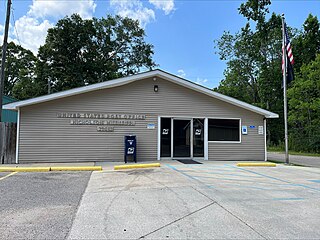
Harperville is a census-designated place and unincorporated community in rural Scott County, Mississippi, United States. Harperville is located on Mississippi Highway 35, 9 miles (14 km) north of Forest. Harperville has a post office with ZIP code 39080. It was first named as a CDP in the 2020 Census which listed a population of 250.

Bethlehem is a census-designated place and unincorporated community in Marshall County, Mississippi, United States. Its ZIP code is 38659.

References

  1. "2020 U.S. Gazetteer Files". United States Census Bureau. Retrieved July 24, 2022.
  2. U.S. Geological Survey Geographic Names Information System: Eastabuchie, Mississippi
  3. USPS – Cities by ZIP Code
  4. Baca, Keith A. (2007). Native American Place Names in Mississippi. University Press of Mississippi. p. 33. ISBN   978-1-60473-483-6.
  5. Howe, Tony. "Eastabuchie, Mississippi". Mississippi Rails. Retrieved June 26, 2022.
  6. "Eastabuchie CDP, Mississippi". United States Census Bureau . Retrieved March 13, 2022.
  7. "Decennial Census of Population and Housing by Decades". US Census Bureau.
  8. 1 2 "P2 HISPANIC OR LATINO, AND NOT HISPANIC OR LATINO BY RACE - 2020: DEC Redistricting Data (PL 94-171) - Eastabuchie CDP, Mississippi". United States Census Bureau .
  9. "2020 CENSUS - SCHOOL DISTRICT REFERENCE MAP: Jones County, MS" (PDF). U.S. Census Bureau . Retrieved April 13, 2022.
  10. "2020 CENSUS - SCHOOL DISTRICT REFERENCE MAP: Forrest County, MS" (PDF). U.S. Census Bureau . Retrieved April 13, 2022.
  11. Lives of Mississippi Authors, 1817-1967. Jackson, Mississippi: University Press of Mississippi. 1981. p. 24.