
Letchworth State Park is a 14,427-acre (5,838 ha) New York State Park located in Livingston County and Wyoming County in the western part of the State of New York. The park is roughly 17 miles (27 km) long, following the course of the Genesee River as it flows north through a deep gorge and over several large waterfalls. It is located 35 miles (56 km) southwest of Rochester and 60 miles (97 km) southeast of Buffalo, and spans portions of the Livingston County towns of Leicester, Mount Morris and Portage, as well as the Wyoming County towns of Castile and Genesee Falls.

Sussex County is the northernmost county in the State of New Jersey. Its county seat is Newton. It is part of the New York metropolitan area and is part of New Jersey's Skylands Region. As of the 2020 U.S. census, the county's population was enumerated at 144,221, making it the 17th-most populous of the state's 21 counties, and representing a decrease of 5,044 (3.4%) from the 149,265 counted at the 2010 U.S. census, in turn an increase of 5,099 (3.5%) over the 144,166 persons at the 2000 census. Based on 2010 census data, Vernon Township was the county's largest in both population and area, with a population of 23,943 and covering an area of 70.59 square miles (182.8 km2).

Kinnelon is a borough in Morris County, New Jersey, United States, located approximately 33 miles (53 km) west of New York City. As of the 2020 United States census, the borough's population was 9,966, a drop of 282 (-2.8%) from the 2010 census count of 10,248, which in turn reflected an increase of 883 (+9.4%) from the 9,365 counted in the 2000 census. It is a low-density, suburban community, with many parks and trails.

Washington Township is a township in Morris County, in the U.S. state of New Jersey. As of the 2020 United States census, the township's population was 18,197, a decrease of 336 (−1.8%) from the 2010 census count of 18,533, which in turn reflected an increase of 941 (+5.3%) from the 17,592 counted in the 2000 census.
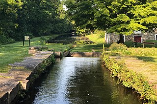
The Morris Canal (1829–1924) was a 107-mile (172 km) common carrier anthracite coal canal across northern New Jersey that connected the two industrial canals at Easton, Pennsylvania across the Delaware River from its western terminus at Phillipsburg, New Jersey to New York Harbor and New York City via its eastern terminals in Newark and on the Hudson River in Jersey City. The canal was sometimes called the Morris and Essex Canal, in error, due to confusion with the nearby and unrelated Morris and Essex Railroad.

Blue Mountain, Blue Mountain Ridge, or the Blue Mountains of Pennsylvania, is a ridge of the Appalachian Mountains in eastern Pennsylvania. Forming the southern and eastern edge of the Ridge-and-Valley Appalachians physiographic province in Pennsylvania, Blue Mountain extends 150 miles (240 km) from the Delaware Water Gap on the New Jersey border in the east to Big Gap in Franklin County in south-central Pennsylvania at its southwestern end.
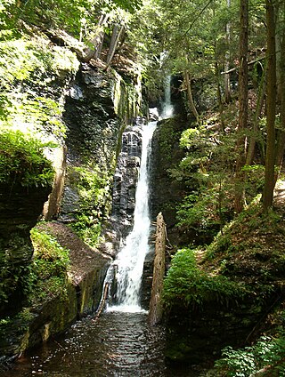
Delaware Water Gap National Recreation Area is a 70,000-acre (28,000 ha) national recreation area administered by the National Park Service in northwest New Jersey and northeast Pennsylvania. It is centered around a 40-mile (64 km) stretch of the Delaware River designated the Middle Delaware National Scenic River. At the area's southern end lays the Delaware Water Gap, a dramatic mountain pass where the river cuts between Blue Mountain and Kittatinny Mountain

The Columbia Trail is a rail trail in rural northwestern New Jersey. It was created from portions of the former Central Railroad of New Jersey High Bridge Branch and stretches from High Bridge, in Hunterdon County, through Washington Township, in Morris County for a total of 15.1 miles (24.3 km). The trail surface is relatively flat and consists mostly of fine crushed stone.

Schooley's or, officially, Schooleys Mountain is a mountain ridge in northern New Jersey that stretches from Lake Hopatcong in the north to Hampton in the south. It is centrally located within the southern Highlands, positioned almost equidistantly from the Kittatinny Valley in the west and the Piedmont plateau in the east. Schooley's Mountain is also one of the largest ridges in a group of geologically similar and parallel mountains, which include Allamuchy Mountain, Pohatcong Mountain, Scotts Mountain, and Jenny Jump Mountain.

The Skylands Region is a region New Jersey located in the Northern and Central part of the state. It is one of six tourism regions established by the New Jersey State Department of Tourism; the others are Gateway Region, Greater Atlantic City Region, the Southern Shore Region, the Delaware River Region, and the Shore Region.

Brookside is a historic unincorporated community within Mendham Township in Morris County, New Jersey, United States. It is located approximately 6 mi (9.7 km) west of Morristown. It is close to the Washington Valley Historic District in neighboring Morris Township.

Port Murray is an unincorporated community and census-designated place (CDP) located within Mansfield Township in Warren County, New Jersey, United States, that was created as part of the 2010 United States Census. As of the 2010 Census, the CDP's population was 129.
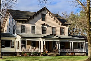
Oak Cottage is a historic home built around 1820 and located in the Schooley's Mountain section of Washington Township in Morris County, New Jersey. The property includes a mill and carriage house built in 1828 and is a contributing property to Schooley's Mountain Historic District, which was listed on the National Register of Historic Places in 1991.
Schooley's Mountain Historic District is a historic district along Schooley's Mountain, Pleasant Grove, and Flocktown Roads, and Heath Lane in the Schooley's Mountain section of Washington Township, Morris County, New Jersey. It was added to the National Register of Historic Places on June 14, 1991 for its significance in architecture, entertainment/recreation, and health/medicine. The district includes 71 contributing buildings, such as the Oak Cottage, site of schoolhouse No. 5, Schooley's Mountain Store, the William W. Marsh House, Christadelphian Bible Camp, the former Heath House Hotel, former Forest Grove Hydropathic Institute, Mine Hill Farm, the Marsh Mine and several private residences and commercial buildings.

Wallpack Center is an unincorporated community located within Walpack Township, Sussex County, New Jersey, United States. Wallpack Center is located in the Flat Brook Valley 6.7 miles (10.8 km) west of Branchville. Wallpack Center has a post office with ZIP code 07881. It is now part of the Delaware Water Gap National Recreation Area.

Readingsburg, also known as Stone Mill, is an unincorporated community located along the South Branch Raritan River within Clinton Township in Hunterdon County, New Jersey.

Washington Valley is an unincorporated community in the Whippany River valley within Morris Township in Morris County, New Jersey.

Middle Valley is an unincorporated community located along Middle Valley Road and County Route 513 in Washington Township, Morris County, New Jersey. It is near Long Valley in the valley of the South Branch Raritan River. The Middle Valley Historic District was listed on the state and national registers of historic places in 1989 and 1990.

The Anthony–Corwin Farm is a historic farmhouse located at 244 West Mill Road near Long Valley in Washington Township, Morris County, New Jersey. It was added to the National Register of Historic Places on May 1, 1992, for its significance in architecture. The 11.5-acre (4.7 ha) farm overlooks the valley formed by the South Branch Raritan River. The farmhouse is part of the Stone Houses and Outbuildings in Washington Township Multiple Property Submission (MPS).

Bevans, also known as Peters Valley, is an unincorporated community located at the intersection of Bevans Road, Walpack Road, and Kuhn Road in Sandyston Township of Sussex County, New Jersey. The village is now part of the Delaware Water Gap National Recreation Area. Both the Delaware River and the Old Mine Road are nearby.


