
The River Cherwell is a tributary of the River Thames in central England. It rises near Hellidon, Northamptonshire and flows southwards for 40 miles (64 km) to meet the Thames at Oxford in Oxfordshire.
Grandpont is a mainly residential area in south Oxford. It is west of Abingdon Road, and consists mainly of narrow streets that run at right angles to the main road, with terraced late-Victorian and Edwardian houses.

Begbroke is a village and civil parish in Oxfordshire about one mile (1.6 km) west of Kidlington and five miles (8 km) northwest of Oxford. The 2011 Census recorded the parish's population as 783.

Bladon is a village and civil parish on the River Glyme about 6+1⁄2 miles (10.5 km) northwest of Oxford, Oxfordshire, England. It is where Sir Winston Churchill is buried. The 2011 Census recorded the parish's population as 898.

New Marston is a suburb about 1.25 miles (2 km) northeast of the centre of Oxford, England.

Shipton-under-Wychwood is a village and civil parish in the Evenlode valley about 4 miles (6.4 km) north of Burford, in the West Oxfordshire district, in the county of Oxfordshire, England. The village is one of three named after the ancient forest of Wychwood. The others are Milton-under-Wychwood immediately to the west of the village and Ascott-under-Wychwood about 1.5 miles (2.4 km) to the east. The 2011 Census recorded Shipton-under-Wychwood's parish population as 1,244.

Summertown in North Oxford is a suburb of Oxford, England. Summertown is a one-mile square residential area, north of St Giles, the boulevard leading out of Oxford's city centre. Summertown is home to several independent schools and the city's most expensive houses. On both sides of Banbury Road are Summertown's popular shops. There is also a smaller street of shops and restaurants, South Parade, that links Banbury Road and Woodstock Road. Summertown is home to much of Oxford's broadcast media. BBC Radio Oxford and the BBC Television's Oxford studios are on Banbury Road. Start-ups also have an increasing presence on the parade, such as Brainomix and Passle. The studios for JACK FM, Glide FM, and Six TV Oxford are on Woodstock Road.

St Clement's is a district in Oxford, England, on the east bank of the River Cherwell. "St Clement's" is usually taken to describe a small triangular area from The Plain bounded by the Cherwell in the West, Cowley Road in the East. to the foot of Headington Hill in the South. It also refers to the ecclesiastical parish of St Clement's which includes some neighbouring areas and is used in the names of local City and County electoral districts.

Cogges is an area beside the River Windrush in Witney, in the West Oxfordshire district, in Oxfordshire, England, 0.5 miles (800 m) east of the town centre. It had been a separate village and until 1932 it was a separate civil parish.
Water Eaton is a hamlet in the civil parish of Gosford and Water Eaton, in the Cherwell district, in the county of Oxfordshire, England. It is between Oxford and Kidlington.

Shipton-on-Cherwell is a village in the civil parish of Shipton-on-Cherwell and Thrupp, in the Cherwell district, in the county of Oxfordshire, England. It is on the River Cherwell about 2 miles (3 km) north of Kidlington in Oxfordshire, England.

Gosford is a village immediately southeast of Kidlington, in the Cherwell district, Oxfordshire, England. It is in the civil parish of Gosford and Water Eaton. The 2011 Census recorded Gosford and Water Eaton's parish population as 1,373.

Thrupp is a hamlet in the civil parish of Shipton-on-Cherwell and Thrupp, in the Cherwell district, in the county of Oxfordshire, England. It is beside the Oxford Canal and close to the River Cherwell, just north of Kidlington.
The Blenheim and Woodstock branch line was a 4-mile (6.4 km) railway branch line that linked Kidlington and Woodstock, Oxfordshire. It ran from Kidlington railway station parallel with the Cherwell Valley Line north to Shipton-on-Cherwell, where it turned west through Shipton-on-Cherwell Halt towards Blenheim and Woodstock.

Lyneham is a village and civil parish about 5 miles (8 km) southwest of Chipping Norton, Oxfordshire. It is bounded to the southwest by the River Evenlode, to the southeast by the A361 road linking Chipping Norton and Burford, and on other sides by field boundaries. The 2011 Census recorded the parish's population as 153.

Claydon with Clattercot is a civil parish in the Cherwell district, in the county of Oxfordshire, England. It was formed in 1932 by merger of the parish of Claydon with the extra-parochial area of Clattercote. As of the United Kingdom Census 2011, its population was 306 and it had a total of 6.22 km2 of land, water, and roads.

Hardwick with Tusmore is a civil parish in the Cherwell district, in the county of Oxfordshire, England. It was formed in 1932 by merger of the parishes of Hardwick and Tusmore. In 2001 it had a population of 63.
Shenington with Alkerton is a civil parish in Oxfordshire, England. It comprises the village of Shenington, which was an exclave of Gloucestershire until the Counties Act 1844 transferred it to Oxfordshire and the village of Alkerton, which was always part of Oxfordshire. It covers 9.60 km2 and as at the 2011 census had a population of 425 people.
Hanborough is a civil parish in West Oxfordshire. The parish includes the villages of Church Hanborough and Long Hanborough. The village of Freeland was transferred from Eynsham civil parish to Hanborough in 1932 and then detached to form a separate civil parish in 1948. Both Church Hanborough and Long Hanborough are served by Hanborough railway station.
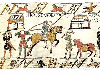
Wadard was an 11th-century Norman nobleman who is mentioned in the Domesday Book of 1086, and is depicted in the Bayeux Tapestry.


