Tusmore, Oxfordshire

Last updated

Tusmore
Tusmore House - geograph.org.uk - 453458.jpg
Tusmore - the present house designed by Sir William Whitfield is at least the fourth on the site
Oxfordshire UK location map.svg
Red pog.svg
Tusmore
Location within Oxfordshire
OS grid reference SP5630
Civil parish
District
Shire county
Region
Country England
Sovereign state United Kingdom
Post town Bicester
Postcode district OX27
Dialling code 01869
Police Thames Valley
Fire Oxfordshire
Ambulance South Central
UK Parliament
List of places
UK
England
Oxfordshire
51°58′01″N1°10′34″W / 51.967°N 01.176°W / 51.967; -01.176

Tusmore is a settlement about 5+12 miles (9 km) north of Bicester in Oxfordshire. It is the location of the Tusmore country house and estate.

Contents

Manor

Tusmore was settled in Saxon times. The toponym comes from Old English, either Thures mere ("Thur's pool") or Þyrsmere ("a lake haunted by a giant or demon"). [1]

The Domesday Book records that in 1086 the manor of Tusmore belonged to Walter Giffard, 1st Earl of Buckingham. [1]

By the early part of the 14th century Tusmore was the poorest village in the Ploughley Hundred. Thereafter it was depopulated by the Black Death. By 1358 the village had been abandoned and Sir Roger de Cotesford was licensed to enclose the abandoned land. The fact that Tusmore was not required to pay tax in 1428 indicates that by then it had fewer than ten householders. [1]

The Fermor family were lords of the manor of Tusmore from 1606 until 1828, and Tusmore House was their family seat from about 1625 until 1810. In 1828 the last William Fermor died without a male heir and left the estate to his adopted daughter and her husband, John and Maria Turner Ramsay. In 1857 the Ramsays sold the estate to Henry Howard, 2nd Earl of Effingham. In 1929 the heir of Henry Alexander Gordon Howard, 4th Earl of Effingham sold the estate to Vivian Smith, a merchant banker who in 1938 was created 1st Baron Bicester of Tusmore. [1] Late in the 1990s the Smiths sold Tusmore to the Syrian billionaire Wafic Saïd.

Church and chapel

Records suggest that Tusmore may have had a parish church by 1074, and it certainly existed by 1236. After the depopulation of Tusmore in the 14th century the church continued as a chapel or free chapel, and fragments of 15th century masonry found on the site indicate that it was rebuilt at that time. It seems to have ceased to exist by the early part of the 16th century, as records of episcopal visitations at that time make no mention of Tusmore. However, the living continued to exist until 1840 when it was united with that of Hardwick. The place names "Church Yard" and "Churchyard Close" indicate roughly where the parish church once stood. [1]

The Fermors were recusants and supported the continuation of Roman Catholicism in Tusmore and neighbouring villages from the English Reformation in the 16th century until after the Roman Catholic Relief Act 1791. The family always had a resident priest, usually a Jesuit, and several Fermors entered religious orders. All of the Fermor's staff were Roman Catholics, and attended Mass at the Fermor chapel at Tusmore along with co-religionists form neighbouring villages. This practice continued uninterrupted except for a period from 1768 when Tusmore House was being rebuilt and the chapel was being refurbished (see below). Mass at Tusmore resumed thereafter and continued until 1810 when the last William Fermor moved out of the house and his priest moved to Hardwick. [1] The chapel was burned down in 1837 and was not rebuilt.

Tusmore Park

Sir Roger de Cotesford or his successors may have built a manor house at Tusmore. It does not survive, but an early 16th-century combined granary and dovecote on staddle stones remains. [2] It is an oak-framed building, which is unusual in a part of England historically dominated by stone buildings. [1] The granary and dovecote are now a Grade II* listed building. [3]

An engraving of Arabella Fermor, published in 1807 Arabella Fermor.jpg
An engraving of Arabella Fermor, published in 1807

The Fermors' house at Tusmore was large, for in 1665 it was assessed as having 19 hearths for the hearth tax. It was built of local stone and had a Roman Catholic chapel as well as ornamental gardens and a fish pond. After 1758 William Fermor had the house demolished except for the chapel and commissioned the Scottish architect Robert Mylne to design a new house. The exterior was completed by 1770 and the interior by 1779. [1] Mylne's house was of seven bays [2] and built of local stone, most of it from Fritwell. Mylne laid out the gardens and landscaped the park, the latter with a lake and an ornamental Temple of Peace dedicated to the late poet Alexander Pope (1688–1744). [1] Pope had been a friend of the Fermor family and in 1712 had written The Rape of the Lock about an incident in which Robert Petre, 7th Baron Petre had offended Arabella Fermor.

In 1857 the new owner, the 2nd Earl of Effingham, commissioned the Scottish architect William Burn to build an office wing on the site of the chapel, which had burned down in 1837. This was completed along with alterations to the house in 1858. After 1929 Vivian Smith had the house restored, most of the Victorian office wing demolished and some other alterations made. [1] Despite the 1858 and 1929 alterations, a number of the principal rooms retained their original 18th-century ceilings in the style of Robert Adam. [2] Smith greatly changed the gardens and park, retaining little of Milne's landscape design except the Temple of Peace and the lake. [1]

Gate lodges to Tusmore Park designed by Whitfield Lockwood Architects Gatehouses, Tusmore Estate - geograph.org.uk - 143112.jpg
Gate lodges to Tusmore Park designed by Whitfield Lockwood Architects

In 1960 Randal Smith, 2nd Baron Bicester had the house demolished, which Sherwood and Pevsner condemned as "a great loss to a county in which important houses of the last quarter of the C18 are few". The stables were retained and are now a separate dwelling. In 1964–65 the architect Claud Phillimore designed a new Tusmore House on the site [2] in a neo-Georgian manner, significantly smaller than the house by Mylne. In 1970 the 2nd Baron died in a car accident and was succeeded by his nephew Angus Smith, 3rd Baron Bicester.

In 2000, the new owner Wafic Saïd replaced Phillimore's house with a grander Anglo-Palladian design on the same site designed by Sir William Whitfield (1920–2019) of Whitfield Lockwood Architects. The house has a two-storey entrance front and a three-storey garden front. In the centre of the house is a three-storey circular staircase hall, reminiscent of that at New Wardour Castle. [4] In 2004 the Georgian Group gave the completed house its award for the "best new building in the Classical tradition", [5] although doctrinaire modernist architectural critics have been sceptical. [6] Outbuildings, lodges and a monumental obelisk to commemorate the Millennium have been completed for Wafic Saïd, all to the design of Whitfield Lockwood. As part of extensive landscape works the patte d'oie has been reinstated and a wide double avenue from the entrance to the house and terminating at the obelisk established.

Air crash

A Handley Page Hampden aircraft similar to that shot down at Tusmore 15 Handley Page Hampden (15650368358).jpg
A Handley Page Hampden aircraft similar to that shot down at Tusmore

On 2 September 1941 a Junkers Ju 88 fighter-bomber of Luftwaffe Nachtjagdgeschwader 2, flown by flying ace Oblt Paul Semrau, bombed RAF Upper Heyford. Meanwhile, a Handley Page Hampden I aircraft, P5314 of No. 16 Operational Training Unit RAF, had been on a night training flight and was preparing to land at its base, RAF Croughton. Semrau fired cannon and machine guns at the Hampden, which caught fire and then crashed into a field near Tusmore Park, killing all four members of the crew. [7]

The Hampden crew were members of the Royal Air Force Volunteer Reserve. The pilot, P/O NP van der Merwe, was from Salisbury in Southern Rhodesia. He and two other crew are buried in the Commonwealth War Graves Commission section of St Mary's parish churchyard, Upper Heyford. The fourth is buried in St Andrew's parish churchyard, Kingsbury, northwest London. [7]

Related Research Articles

<span class="mw-page-title-main">Upper Heyford, Oxfordshire</span> Human settlement in England

Upper Heyford is a village and civil parish about 6 miles (10 km) northwest of Bicester in Oxfordshire, England. The 2011 Census recorded the parish's population as 1,295.

<span class="mw-page-title-main">Banbury (UK Parliament constituency)</span> Parliamentary constituency in the United Kingdom, 1801 onwards

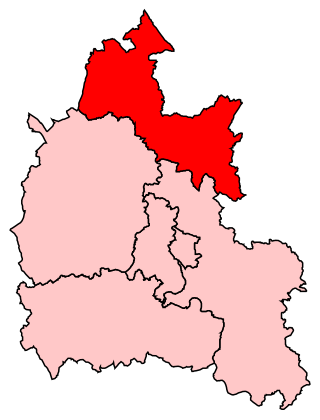
Banbury is a constituency in Oxfordshire created in 1553 and represented in the House of Commons of the UK Parliament since 2015 by Victoria Prentis of the Conservative Party. She currently serves as Attorney General for England and Wales.

<span class="mw-page-title-main">Islip, Oxfordshire</span> Human settlement in England

Islip is a village and civil parish on the River Ray, just above its confluence with the River Cherwell in Oxfordshire, England. It is about 2 miles (3 km) east of Kidlington and about 5 miles (8 km) north of Oxford. The 2011 Census recorded the parish's population as 652.

<span class="mw-page-title-main">Lower Heyford</span> Human settlement in England

Lower Heyford is a village and civil parish beside the River Cherwell in Oxfordshire, about 6 miles (10 km) west of Bicester. The 2011 Census recorded the parish's population as 492.

<span class="mw-page-title-main">Bucknell, Oxfordshire</span> Village in Oxfordshire, England

Bucknell is a village and civil parish 2+12 miles (4 km) northwest of Bicester in Oxfordshire, England. The 2011 Census recorded the parish's population as 260.

<span class="mw-page-title-main">Kirtlington</span> Human settlement in England

Kirtlington is a village and civil parish in Oxfordshire about 6+12 miles (10.5 km) west of Bicester. The parish includes the hamlet of Northbrook. The 2011 Census recorded the parish's population as 988.

<span class="mw-page-title-main">Launton</span> Human settlement in England

Launton is a village and civil parish on the eastern outskirts of Bicester, Oxfordshire, England. The 2011 Census recorded the parish's population as 1,204.

<span class="mw-page-title-main">Middleton Stoney</span> Human settlement in England

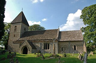
Middleton Stoney is a village and civil parish about 2+12 miles (4 km) west of Bicester, Oxfordshire. The 2011 Census recorded the parish's population as 331.

<span class="mw-page-title-main">Rousham</span> Human settlement in England

Rousham is a village and civil parish beside the River Cherwell in Oxfordshire. The village is about 6+12 miles (10.5 km) west of Bicester and about 6 miles (10 km) north of Kidlington. The parish is bounded by the River Cherwell in the east, the A4260 main road between Oxford and Banbury in the west, partly by the B4030 in the north, and by field boundaries with Tackley parish in the south. The 2001 Census recorded the parish's population as 80. Rousham was founded early in the Anglo-Saxon era. Its toponym is derived from Old English meaning Hrothwulf's ham or farm.

<span class="mw-page-title-main">Fringford</span> Human settlement in England

Fringford is a village and civil parish in Oxfordshire, about 4 miles (6.4 km) northeast of Bicester. The parish is bounded to the east by the Roman road that linked Alchester Roman Town with Roman Towcester, to the south by a brook that joins the River Bure, to the north mostly by a brook that is a tributary of the River Great Ouse, and to the west by field boundaries. Fringford village is in the north of the parish, surrounded on two sides by a bend in the tributary of the Great Ouse.

<span class="mw-page-title-main">Pyrton</span> Village in Oxfordshire, England

Pyrton is a small village and large civil parish in Oxfordshire about 1 mile (1.6 km) north of the small town of Watlington and 5 miles (8 km) south of Thame. The 2011 Census recorded the parish's population as 227. The toponym is from the Old English meaning "pear-tree farm".

<span class="mw-page-title-main">Somerton, Oxfordshire</span> Human settlement in England

Somerton is a village and civil parish in Oxfordshire, England, in the Cherwell valley about 6 miles (10 km) northwest of Bicester. The 2011 Census recorded the parish's population as 305.

<span class="mw-page-title-main">Wendlebury</span> Human settlement in England

Wendlebury is a village and civil parish about 2 miles (3 km) southwest of Bicester and about 12 mile (800 m) from Junction 9 of the M40. Junction 9 is where the A34 and A41 roads meet the M40, and it is also called the Wendlebury Interchange.

<span class="mw-page-title-main">Chesterton, Oxfordshire</span> Human settlement in England

Chesterton is a village and civil parish on Gagle Brook, a tributary of the Langford Brook in north Oxfordshire. The village is about 1+12 miles (2.4 km) southwest of the market town of Bicester. The village has sometimes been called Great Chesterton to distinguish it from the hamlet of Little Chesterton, about 34 mile (1.2 km) to the south in the same parish. The 2011 Census recorded the parish population as 850.

<span class="mw-page-title-main">Godington</span> Human settlement in England

Godington is a village and civil parish about 5 miles (8 km) northeast of Bicester in Oxfordshire. The parish is bounded on all but the west side by a brook called the Birne, which at this point forms also the county boundary with Buckinghamshire. The parish was included in the figures of Stratton Audley for the purposes of the United Kingdom Census 2011.

<span class="mw-page-title-main">Hardwick, Cherwell</span> Human settlement in England

Hardwick is a village in the civil parish of Hardwick with Tusmore about 4.5 miles (7 km) north of Bicester in Oxfordshire.

<span class="mw-page-title-main">Hethe</span> Human settlement in England

Hethe is a village and civil parish about 4.5 miles (7.2 km) north of Bicester in Oxfordshire, England.

<span class="mw-page-title-main">Cottisford</span> Human settlement in England

Cottisford is a village and civil parish in Oxfordshire, about 3.5 miles (5.6 km) south of Brackley in neighbouring Northamptonshire. The parish's northern and northwestern boundaries form part of the boundary between the two counties. The parish includes the hamlet of Juniper Hill about 1 mile (1.6 km) northwest of Cottisford. The 2011 Census recorded the parish's population as 216.

<span class="mw-page-title-main">Fritwell</span> Human settlement in England

Fritwell is a village and civil parish about 5+12 miles (9 km) northwest of Bicester in Oxfordshire. The 2011 Census recorded the parish's population as 736.

<span class="mw-page-title-main">Souldern</span> Human settlement in England

Souldern is a village and civil parish in Oxfordshire about 7 miles (11 km) northwest of Bicester and a similar distance southeast of Banbury. The parish is bounded to the west by the River Cherwell and to the east by field boundaries. Its northern boundary is Ockley Brook, a tributary of the Cherwell that forms the county boundary with Northamptonshire. The parish's southern boundaries are the main road between Bicester and Adderbury and the minor road between Souldern and Somerton. The 2011 Census recorded the parish's population as 370.

References

  1. 1 2 3 4 5 6 7 8 9 10 11 Lobel 1959, pp. 333–338.
  2. 1 2 3 4 Sherwood & Pevsner 1974, p. 820.
  3. Historic England. "Granary/Dovecote at SP56523068 (Grade II*) (1046450)". National Heritage List for England . Retrieved 17 January 2012.
  4. "Tusmore Park". Lost Heritage. Matthew Beckett. Archived from the original on 9 June 2009.
  5. "Architectural Awards/ 2004 Awards". The Georgian Group.
  6. Glancey, Jonathan (3 November 2004). "I built it. Me. Moi". The Guardian . Retrieved 22 October 2009.
  7. 1 2 "20.09.1941 No. 16 O.T.U. Hampden I P5314 P/O Van der Merwe". Archive Report: Allied Forces. Aircrew Remembered. Retrieved 13 November 2015.

Sources and further reading