Launton

Last updated

Launton
St Mary's Church, Launton - geograph.org.uk - 61239.jpg
St Mary's parish church
Oxfordshire UK location map.svg
Red pog.svg
Launton
Location within Oxfordshire
Area10.49 km2 (4.05 sq mi)
Population1,204 (2011 Census)
  Density 115/km2 (300/sq mi)
OS grid reference SP6022
Civil parish
  • Launton
District
Shire county
Region
Country England
Sovereign state United Kingdom
Post town Bicester
Postcode district OX26
Dialling code 01869
Police Thames Valley
Fire Oxfordshire
Ambulance South Central
UK Parliament
Website Launton Village Website
List of places
UK
England
Oxfordshire
51°53′35″N1°06′58″W / 51.893°N 1.116°W / 51.893; -1.116

Launton is a village and civil parish on the eastern outskirts of Bicester, Oxfordshire, England. The 2011 Census recorded the parish's population as 1,204. [1]

Contents

Manor

King Edward the Confessor granted the manor of Launton to Westminster Abbey in 1065. The abbey surrendered the manor to the Crown when it was suppressed in the Dissolution of the Monasteries in 1540, but in 1542 the Crown granted Launton to the abbey's Dean and Chapter. Mary I restored the Roman Catholic church in England so in 1556 Launton was surrendered to the Crown, who restored it to the reinstated abbott and convent of Westminster. Elizabeth I restored the English Reformation so in 1560 Launton was surrendered to the Crown for a third time, who again granted it to the Dean and Chapter. In 1649 the Commonwealth of England assigned Launton to Westminster School. In 1860 the lands of the Dean and Chapter of Westminster were vested in the Ecclesiastical Commissioners. [2]

The present manor house is 17th-century, with a court room that was re-ordered in the 19th century. [3] Its farmyard has a 14th- or 15th-century barn of 10 bays with 17th-century roof timbers. The barn may have been a tithe barn and now forms the centrepiece of a wedding venue called 'The Tythe Barn' after being restored in 1997. [4] [5] It is now a Grade II* listed building. [6]

Church and chapels

Church of England

The Church of England parish church of the Assumption of the Blesséd Virgin Mary was built in the 12th century, and the four-bay aisles of its nave were added in the 13th century. [7] [8] Sources disagree as to whether the west tower is part of the original 12th-century church [8] or a 13th-century addition. [7] Originally the chancel had an apse, but in the 15th century this part of the church was reordered with a rectangular east end. [8] [9] The nave has a clerestory with 15th- or 16th-century windows. [8] Some of the windows of the aisles are 16th-century. [8] [9]

In 1891 a pair of flying buttresses designed by Reginald Blomfield was added to the west tower. In 1910 an Arts and Crafts-style screen designed by John Oldrid Scott was added to the south aisle. The church is Grade I listed. [8]

The bell tower has a ring of six bells, all cast by Gillett & Johnston of Croydon in 1907. [10] The church also has a Sanctus bell that was cast in 1352. [2]

In the churchyard are the base and broken shaft of a 14th- or 15th-century stone churchyard cross. [11]

The ecclesiastical parish is now part of the Benefice of Bicester, Bucknell, Caversfield and Launton. [12] [13]

Presbyterian chapel

Launton had a Presbyterian congregation by 1772, when a meeting house was licensed for it. The congregation lapsed by about 1800, but was re-established by 1806. In 1807 Zion chapel was built for it on the western edge of the village. Later in the 19th century the chapel was used as a school. [2]

Congregational chapel

Bethel chapel was built in 1850 for an independent Nonconformist congregation. By 1855 it had a lending library and a school. It later joined the Congregational Church. [2] [14]

Economic history

The Varsity Line between Bletchley and Oxford via Bicester Town was built through Launton parish and opened in 1851. Launton railway station served the village until the end of 1967, when British Railways withdrew passenger services between Bletchley and Oxford.

Amenities

The Black Bull, renamed in 2020 to The Launton Arms The Black Bull, Launton - geograph.org.uk - 218851.jpg
The Black Bull, renamed in 2020 to The Launton Arms

Launton has two public houses: The Bull Inn at the crossroads in the centre of the village and The Launton Arms (formerly The Black Bull) at West End. [15] The village has also a post office, a butchers and a hair salon.

Launton has a Church of England primary school. [16] The school has links with the parish church including Christingle and Year Six leavers services.

Launton has a Parish Hall. The Sports and Social Club provides the home pitch for Launton Football Club, plus a tennis court and small children's play area. [17]

The Launton Village Players is an amateur theatre group living in and around Launton who perform an annual pantomime at The Cooper School in Bicester, and musical shows and plays in the village. [18]

The village has a Woods on your Doorstep [19] at Island Pond Wood, managed by The Woodland Trust. [20] Villagers bought it by public subscription and planted it in 1999. [20]

Launton has a Non-League football club, Launton Sports F.C., which plays at Launton Sports Club on Bicester Road.

Buses

Stagecoach in Oxfordshire bus route 28 links Launton with Bicester. [21] Buses run hourly, Monday to Saturday. There is no service on Sunday or on public holidays. [22]

In school terms, coaches to and from Blessed George Napier Roman Catholic School in Banbury also serve Launton.[ citation needed ]

Twinning

Launton is twinned with the village of Gavray in the Lower Normandy region of France.

Related Research Articles

<span class="mw-page-title-main">Upper Heyford, Oxfordshire</span> Human settlement in England

Upper Heyford is a village and civil parish about 6 miles (10 km) northwest of Bicester in Oxfordshire, England. The 2011 Census recorded the parish's population as 1,295.

<span class="mw-page-title-main">Merton, Oxfordshire</span> Human settlement in England

Merton is a village and civil parish near the River Ray, about 4 miles (6.4 km) south of Bicester in Oxfordshire, England. The 2011 Census recorded the parish's population as 424.

<span class="mw-page-title-main">Ambrosden</span> Human settlement in England

Ambrosden is a village and civil parish in Cherwell, Oxfordshire, England, 3 miles (5 km) southwest of Bicester to which it is linked by the A41 road, and 13 miles (21 km) from Oxford. The 2011 Census recorded the parish's population as 2,248. The parish is bounded by the River Ray to the south, its tributary the River Bure to the west, the outskirts of Bicester to the north and field boundaries to the east.

<span class="mw-page-title-main">Shilton, Oxfordshire</span> Human settlement in England

Shilton is a village and civil parish about 1+12 miles (2.4 km) northwest of Carterton, Oxfordshire. The 2011 Census recorded the parish's population as 626.

<span class="mw-page-title-main">Lower Heyford</span> Human settlement in England

Lower Heyford is a village and civil parish beside the River Cherwell in Oxfordshire, about 6 miles (10 km) west of Bicester. The 2011 Census recorded the parish's population as 492.

<span class="mw-page-title-main">Black Bourton</span> Human settlement in England

Black Bourton is a village and civil parish about 2 miles (3 km) south of Carterton, Oxfordshire. The village is on Black Bourton Brook, a tributary of the River Thames. The 2011 Census recorded the parish population as 266. RAF Brize Norton adjoins the parish. The northern boundary of the parish is along the middle of the main runway of the airfield.

<span class="mw-page-title-main">Bucknell, Oxfordshire</span> Village in Oxfordshire, England

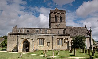
Bucknell is a village and civil parish 2+12 miles (4 km) northwest of Bicester in Oxfordshire, England. The 2011 Census recorded the parish's population as 260.

<span class="mw-page-title-main">Enstone</span> Village and civil parish in Oxfordshire, England

Enstone is a village and civil parish in England, about 4 miles (6.4 km) east of Chipping Norton and 15 miles (24 km) north-west of Oxford city. The civil parish, one of Oxfordshire's largest, consists of the villages of Church Enstone and Neat Enstone, with the hamlets of Chalford, Cleveley, Fulwell, Gagingwell, Lidstone and Radford. The 2011 Census put the parish population as 1,139 living in 453 households. It was estimated at 1,256 in 2019.

<span class="mw-page-title-main">Hampton Poyle</span> Human settlement in England

Hampton Poyle is a village in the Cherwell valley in Oxfordshire, England, about 1 mile (1.6 km) northeast of Kidlington and about 5 miles (8 km) north of the centre of Oxford. It is part of the civil parish of Hampton Gay and Poyle.

<span class="mw-page-title-main">Kirtlington</span> Human settlement in England

Kirtlington is a village and civil parish in Oxfordshire about 6+12 miles (10.5 km) west of Bicester. The parish includes the hamlet of Northbrook. The 2011 Census recorded the parish's population as 988.

<span class="mw-page-title-main">Middleton Stoney</span> Human settlement in England

Middleton Stoney is a village and civil parish about 2+12 miles (4 km) west of Bicester, Oxfordshire. The 2011 Census recorded the parish's population as 331.

<span class="mw-page-title-main">Stanton Harcourt</span> Human settlement in England

Stanton Harcourt is a village and civil parish in Oxfordshire about 4 miles (6.4 km) southeast of Witney and about 6 miles (10 km) west of Oxford. The parish includes the hamlet of Sutton, 12 mile (800 m) north of the village. The 2011 Census recorded the parish's population as 960.

<span class="mw-page-title-main">Somerton, Oxfordshire</span> Human settlement in England

Somerton is a village and civil parish in Oxfordshire, England, in the Cherwell valley about 6 miles (10 km) northwest of Bicester. The 2011 Census recorded the parish's population as 305.

<span class="mw-page-title-main">Chesterton, Oxfordshire</span> Human settlement in England

Chesterton is a village and civil parish on Gagle Brook, a tributary of the Langford Brook in north Oxfordshire. The village is about 1+12 miles (2.4 km) southwest of the market town of Bicester. The village has sometimes been called Great Chesterton to distinguish it from the hamlet of Little Chesterton, about 34 mile (1.2 km) to the south in the same parish. The 2011 Census recorded the parish population as 850.

<span class="mw-page-title-main">Tusmore, Oxfordshire</span> Human settlement in England

Tusmore is a settlement about 5+12 miles (9 km) north of Bicester in Oxfordshire. It is the location of the Tusmore country house and estate.

<span class="mw-page-title-main">Caversfield</span> Human settlement in England

Caversfield is a village and civil parish about 1+12 miles (2.4 km) north of the centre of Bicester. In 1844 Caversfield became part of Oxfordshire, but until then it was always an exclave of Buckinghamshire. The 2011 Census recorded the parish's population as 1,788.

<span class="mw-page-title-main">Hardwick, Cherwell</span> Human settlement in England

Hardwick is a village in the civil parish of Hardwick with Tusmore about 4.5 miles (7 km) north of Bicester in Oxfordshire.

<span class="mw-page-title-main">Hethe</span> Human settlement in England

Hethe is a village and civil parish about 4.5 miles (7.2 km) north of Bicester in Oxfordshire, England.

<span class="mw-page-title-main">Great Haseley</span> Human settlement in England

Great Haseley is a village and civil parish in South Oxfordshire, England. The village is about 4.5 miles (7 km) southwest of Thame. The parish includes the hamlets of Latchford, Little Haseley and North Weston and the house, chapel and park of Rycote. The parish stretches 6 miles (10 km) along a northeast — southwest axis, bounded by the River Thame in the north, Haseley Brook in the south and partly by a boundary hedge with Little Milton parish in the west. The 2011 Census recorded a parish population of 511.

Ipsden is a village and civil parish in the Chiltern Hills in South Oxfordshire, about 3 miles (5 km) southeast of Wallingford. It is almost equidistant from Oxford and Reading, Berkshire.

References

  1. "Launton Parish". nomis. Durham University for the Office for National Statistics . Retrieved 10 January 2021.
  2. 1 2 3 4 Lobel 1959 , pp. 232–243
  3. Historic England. "Manor Farmhouse (Grade II) (1232878)". National Heritage List for England . Retrieved 13 August 2015.
  4. "The Tythe Barn – Wedding Venue, Private Parties & Corporate Events" . Retrieved 9 December 2021.
  5. Rogers, Joseph (2021). Tithe barns. Stroud, Gloucestershire. pp. 85–86. ISBN   978-1-4456-9285-2. OCLC   1242784225.{{cite book}}: CS1 maint: location missing publisher (link)
  6. Historic England. "Barn approximatery 50 metres south of Manor Farmhouse (Grade II*) (1232879)". National Heritage List for England . Retrieved 13 August 2015.
  7. 1 2 Sherwood & Pevsner 1974, pp. 681.
  8. 1 2 3 4 5 6 Historic England. "Church of St Mary (Grade I) (1369735)". National Heritage List for England . Retrieved 13 August 2015.
  9. 1 2 Sherwood & Pevsner 1974, pp. 682.
  10. Davies, Peter (17 December 2006). "Launton Assumption of the BVM". Dove's Guide for Church Bell Ringers . Retrieved 19 December 2011.
  11. Historic England. "Churchyard cross approximately 6 metres south of the Church of St Mary, Bicester Road (Grade II) (1276857)". National Heritage List for England . Retrieved 13 August 2015.
  12. "St Mary's Church". Launton Website. 15 May 2017. Retrieved 10 January 2021.
  13. "Associated Churches". St Edburg's Church – Bicester. Retrieved 10 January 2021.
  14. "Launton". Oxfordshire Churches & Chapels. Brian Curtis. Archived from the original on 24 September 2015. Retrieved 13 August 2015.
  15. "Introducing the Launton Arms" . Retrieved 22 September 2020.
  16. Launton Church of England School
  17. "Launton Sports and Social Club". Launton Village Website. 2010. Archived from the original on 19 August 2011. Retrieved 26 July 2010.
  18. "Launton Village Players". Launton Village Website. 2010. Archived from the original on 1 March 2011. Retrieved 26 July 2010.
  19. "Woods on your Doorstep". Projects. The Woodland Trust. 2010. Retrieved 26 July 2010.
  20. 1 2 "Island Pond Wood". A to Z list. The Woodland Trust. 2010. Archived from the original on 7 May 2009. Retrieved 26 July 2010.
  21. "Oxfordshire Dayrider Gold and Megarider Gold zone" (.pdf). Stagecoach in Oxfordshire. 4 January 2021. Retrieved 10 January 2021.
  22. "28 Bicester - Launton" (PDF). Stagecoach in Oxfordshire. 4 January 2021. Retrieved 10 January 2021.

Sources and further reading