Slaughterville, Oklahoma

Last updated

Slaughterville, Oklahoma
Motto: 
"Dedicated to Country Living"
Cleveland County, Oklahoma Incorporated and Unincorporated areas highlighting Slaughterville.svg
Location of Slaughterville in Cleveland County and Oklahoma
Coordinates: 35°05′54″N97°14′30″W / 35.09833°N 97.24167°W / 35.09833; -97.24167
Country United States
State Oklahoma
County Cleveland
Area
[1]
  Total39.00 sq mi (101.01 km2)
  Land38.63 sq mi (100.05 km2)
  Water0.37 sq mi (0.96 km2)
Elevation
[2]
1,171 ft (357 m)
Population
 (2020)
  Total4,163
  Density107.76/sq mi (41.61/km2)
Time zone UTC-6 (Central (CST))
  Summer (DST) UTC-5 (CDT)
FIPS code 40-67950 [3]
GNIS feature ID2413296 [2]
Website www.town.slaughterville.ok.us

Slaughterville is a town in Cleveland County, Oklahoma, United States, and located in the Oklahoma City metropolitan area. As of the 2020 census, the city population was 4,163, a 0.6% increase from 2010. [4]

Contents

The community is made up of mostly homes on acreages so it has retained a rural type of land use. Much of the area is wooded and has a natural scenic outdoor appeal to residents and visitors.

History

Slaughterville was named after a grocery store run by James Slaughter in the early 20th century. [5] [6]

The site was located in the Unassigned Lands of Indian Territory. It was opened to settlement in the Land Run of 1889. The first building was erected in the same year. The town did not incorporate until 1970, to avoid annexation by either Norman, Noble, or Lexington. [7]

Slaughterville encompassed 27 square miles (70 km2) at incorporation. It deannexed about 40 percent of the area during the 1980s, but later annexed more land and by 2000 had an area of 38.108 square miles (98.70 km2). [7]

The town name was the subject of controversy in 2004 when People for the Ethical Treatment of Animals (PETA) asked Slaughterville to rename the town to Veggieville, offering a donation of $20,000 of veggie burgers as incentive. Slaughterville's town council heard presentations by members of PETA and local citizens before voting against the suggestion. [8]

Geography

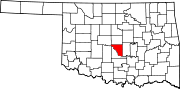
Slaughterville is located in southern Cleveland County. It is bordered to the north by the city of Norman and to the northwest by Noble. Part of its western border touches the Canadian River, across which is McClain County.

U.S. Route 77 passes through the town, leading north 33 miles (53 km) to the center of Oklahoma City and south 6 miles (9.7 km) to Purcell.

According to the United States Census Bureau, the town of Slaughterville has a total area of 38.5 square miles (99.6 km2), of which 38.1 square miles (98.7 km2) is land and 0.35 square miles (0.9 km2), or 0.91%, is water. [9]

Demographics

Historical population
CensusPop.Note
1980 1,953
1990 1,843−5.6%
2000 3,60995.8%
2010 4,13714.6%
2020 4,1630.6%
U.S. Decennial Census [10]

In 2015, there were 4,217 people, [11] 1,431 households, and 1,119 families [12] residing in the town. The population density was 110.7 inhabitants per square mile (42.7/km2). There were 1,614 housing units at an average density of 42.4 per square mile (16.4/km2). The racial makeup of the town was 86.1% White, 6.6% Native American, and 7.2% from two or more races. Hispanic or Latino of any race were 2.2% of the population.

There were 1,431 households, out of which 35.6% had children under the age of 18 living with them, 62.2% were married couples living together, 13.1% had a female householder with no husband present, and 21.8% were non-families. 14.7% of all households were made up of individuals, and 4.0% had someone living alone who was 65 years of age or older. The average household size was 2.95 and the average family size was 3.33.

In the town, the population was spread out, with 28.5% under the age of 18, 9.1% from 18 to 24, 19.9% from 25 to 44, 30.0% from 45 to 64, and 12.5% who were 65 years of age or older. The median age was 39 years. For every 100 females, there were 85.2 males. For every 100 females age 18 and over, there were 86.8 males. [13]

The median income for a household in the town was $50,982, and the median income for a family was $55,023. The per capita income for the town was $20,011. About 7.4% of families and 11.4% of the population were below the poverty line, including 15.3% of those under age 18 and 3.4% of those age 65 or over. [14]

Related Research Articles

<span class="mw-page-title-main">Texas County, Oklahoma</span> County in Oklahoma, United States

Texas County is a county located in the panhandle of the U.S. state of Oklahoma. Its county seat is Guymon. As of the 2020 census, the population was 21,384. It is the second largest county in Oklahoma, based on land area, and is named for Texas, the state that adjoins the county to its south. Texas County comprises the Guymon, OK Micropolitan Statistical Area. The county economy is largely based on farming and cattle production. It is one of the top-producing counties in the U.S. for wheat, cattle, and hogs. It also lies within the noted Hugoton-Panhandle natural gas field.

<span class="mw-page-title-main">Rogers County, Oklahoma</span> County in Oklahoma, United States

Rogers County is located in the northeastern part of the U.S. state of Oklahoma. As of the 2020 census, the population was 95,240, making it the sixth-most populous county in Oklahoma. The county seat is Claremore. Rogers County is included in the Tulsa, OK metropolitan statistical area.

<span class="mw-page-title-main">Northwest Harwinton, Connecticut</span> Census-designated place in Connecticut, United States

Northwest Harwinton is a census-designated place (CDP) in the town of Harwinton in Litchfield County, Connecticut, United States. The population was 3,158 at the 2020 census, out of 5,484 in the entire town. The CDP contains the town center.

<span class="mw-page-title-main">Hazleton, Iowa</span> City in Iowa, United States

Hazleton is a city in Buchanan County, Iowa, United States. The population was 713 at the time of the 2020 census.

<span class="mw-page-title-main">Bethel Township, Michigan</span> Civil township in Michigan, United States

Bethel Township is a civil township of Branch County in the U.S. state of Michigan. As of the 2020 census, the township population was 1,431.

<span class="mw-page-title-main">Evansville, Minnesota</span> City in Minnesota, United States

Evansville is a city in Douglas County, Minnesota, United States. The population was 603 at the 2020 census.

<span class="mw-page-title-main">Surry, New Hampshire</span> Town in New Hampshire, United States

Surry is a town in Cheshire County, New Hampshire, United States. The population was 820 at the 2020 census, up from 732 at the 2010 census.

<span class="mw-page-title-main">Stratford, New Hampshire</span> Town in New Hampshire, United States

Stratford is a town located on the Connecticut River in Coös County, New Hampshire, United States. The population was 662 at the 2020 census, a decline from the figure of 746 tabulated in 2010. Within the town are the villages of North Stratford, Stratford Hollow, and Beatties. U.S. Route 3 passes through the center of town, as does the St. Lawrence and Atlantic Railroad, formerly a part of the Grand Trunk Railway.

<span class="mw-page-title-main">Burlington, Oklahoma</span> Town in Oklahoma, United States

Burlington is a town in northwestern Alfalfa County, Oklahoma, United States. The population was 152 at the 2010 census.

<span class="mw-page-title-main">Keyes, Oklahoma</span> Town in Oklahoma, United States

Keyes is a town in Cimarron County, Oklahoma, United States. As of the 2020 census, the town’s population was 276.

<span class="mw-page-title-main">Noble, Oklahoma</span> City in Oklahoma, United States

Noble is a city in Cleveland County, Oklahoma, United States, and is part of the Oklahoma City Metropolitan Area. The population was 6,985 at the 2020 census, a 7.8% increase from 2010. Noble is Cleveland County's third-largest city behind Norman and Moore.

<span class="mw-page-title-main">Erin Springs, Oklahoma</span> Town in Oklahoma, United States

Erin Springs is a town in Garvin County, Oklahoma, United States. The population was 87 at the 2010 census, a decline of 23.7 percent from the figure of 114 in 2000.

<span class="mw-page-title-main">Hennessey, Oklahoma</span> Town in Oklahoma, United States

Hennessey is a town in Kingfisher County, Oklahoma, United States. The population was 2,131 at the 2010 census, up from 2,058 in 2000.

<span class="mw-page-title-main">Loyal, Oklahoma</span> Town in Oklahoma, United States

Loyal is a town in Kingfisher County, Oklahoma, United States. The population was 79 at the 2010 census.

<span class="mw-page-title-main">Wellston, Oklahoma</span> Town in Oklahoma, United States

Wellston is a town in Lincoln County, Oklahoma, United States. The population was 788 at the 2010 census.

<span class="mw-page-title-main">Luther, Oklahoma</span> Town in Oklahoma, United States

Luther is a town in Oklahoma County, Oklahoma, United States, and a part of the Oklahoma City Metropolitan Area. The population was 1,221 at the 2010 census. Sperling Best Places lists the population of 4073 for the 73054 Luther zip code, which includes the town and immediate surrounding area of rural residents.

<span class="mw-page-title-main">Macomb, Oklahoma</span> Town in Oklahoma, United States

Macomb is a town in Pottawatomie County, Oklahoma, United States. The population was 32 at the 2010 census, which represented a decline of 47.5 percent from the figure of 61 in 2000.

<span class="mw-page-title-main">Hooker, Oklahoma</span> City in Oklahoma, United States

Hooker is a city in Texas County, Oklahoma, United States. As of the 2020 census, the city’s population was 1,802. It is located approximately 20 miles northeast of Guymon on US Route 54 highway.

<span class="mw-page-title-main">New Milford (CDP), Connecticut</span> Census-designated place in Connecticut, United States

Downtown New Milford is a district/census-designated place (CDP) in Litchfield County, Connecticut, United States. It comprises the main population center within the town of New Milford. As of the 2010 census, the population of Downtown New Milford was 6,523, out of 28,142 in the entire town of New Milford.

<span class="mw-page-title-main">Mooers, New York</span> Town in New York, United States

Mooers is a town in Clinton County, New York, United States. The population was 3,592 at the 2010 census. The town is named after Benjamin Mooers, an early settler.

References

  1. "ArcGIS REST Services Directory". United States Census Bureau. Retrieved September 20, 2022.
  2. 1 2 U.S. Geological Survey Geographic Names Information System: Slaughterville, Oklahoma
  3. "U.S. Census website". United States Census Bureau . Retrieved January 31, 2008.
  4. "2010 City Population and Housing Occupancy Status". U.S. Census Bureau. Retrieved August 17, 2012.[ dead link ]
  5. "Slaughterville, Oklahoma". Town of Slaughterville.
  6. "PETA Has a Beef With Slaughterville". Fox News. February 16, 2004. Retrieved August 18, 2012.
  7. 1 2 O'Dell, Larry. Encyclopedia of Oklahoma History and Culture. "Slaughterville." Retrieved December 1, 2012.
  8. "USATODAY.com - Sorry PETA, the name sticks".
  9. "Geographic Identifiers: 2010 Demographic Profile Data (G001): Slaughterville town, Oklahoma". U.S. Census Bureau, American Factfinder. Archived from the original on February 12, 2020. Retrieved March 2, 2015.
  10. "Census of Population and Housing". Census.gov. Retrieved June 4, 2015.
  11. Bureau, U.S. Census. "American FactFinder - Results". Archived from the original on February 13, 2020. Retrieved June 23, 2016.
  12. Bureau, U.S. Census. "American FactFinder - Results". Archived from the original on February 13, 2020. Retrieved June 23, 2016.
  13. Bureau, U.S. Census. "American FactFinder - Results". Archived from the original on February 13, 2020. Retrieved June 23, 2016.
  14. Bureau, U.S. Census. "American FactFinder - Results". Archived from the original on February 13, 2020. Retrieved June 23, 2016.