St Cuthbert's Swallet

Last updated

St Cuthbert's Swallet
St Cuthberts Swallet - geograph.org.uk - 1209429.jpg
Location Priddy
OS grid ST 543 505
Depth145 metres (476 ft)
Length6.7 kilometres (4 mi)
GeologyLimestone
AccessBristol Exploration Club
Cave survey Geological Conservation Review/Bristol Exploration Club
RegistryMendip Cave Registry [1]

St Cuthbert's Swallet is the second longest, and most complex, cave on the Mendip Hills, in Somerset, England. It forms a major part of the Priddy Caves system and water entering this swallet re-emerges at Wookey Hole. [2] St Cuthbert's Swallet is part of, and lies underneath, the Priddy Pools Site of Special Scientific Interest. [3]

Contents

It is named because of its location in the St Cuthbert Out parish of Wells, and was originally called St Cuthbert's Pot. [4]

History

Interest in the possible existence of a cave at this location existed before 1927, and increased when St Cuthbert's Pool suddenly drained away in that year. Attempts to discover an entrance took place between 1944 and 1953, when entry was finally gained. Exploration continued to push the known limits of the cave throughout the 1950s and 1960s. Sump 1 was passed in 1969. Sump 2 has not yet been passed. [2]

Access

Due to a still enforceable court injunction dating from 1863, which required that the stream now known to run through the cave to Wookey Hole was not polluted, [5] the cave is locked and access is controlled by the Bristol Exploration Club on behalf of the landowners. No novices are allowed to enter. [2]

Description

Boulder collapse in St Cuthbert's Swallet St Cuthberts Swallet.jpg
Boulder collapse in St Cuthbert's Swallet

St Cuthbert's Swallet is a classic example of a deep phreatic cave system developed at a depth of not less than 85 metres (280 ft) beneath the water table. [6] It contains inclined bedding plane mazes at many levels, fault-guided rifts and some significant chambers. Nine successive phases of sediment deposition, stalagmite deposition and stream erosion have been recognised at the site, providing an exceptional record of environmental change through the warm and cold phases of the Ice Age.

St. Cuthbert's Swallet is attractive to cavers, for its complexity and size, reaching over 6.7 kilometres (4.2 mi) and a depth of 145 metres (476 ft), and having numerous large decorated chambers, forming phreatic mazes on seven distinct levels. Among its displays are large and impressive calcite groups such as the 'Curtains', 'Cascade', Gour Hall with its 6.1-metre (20 ft) gour, 'The Beehive', Canyon Series and the 'Balcony' formations in September Chamber, perhaps some of the best in Britain. There are also mini-formations including floating calcite crystals, over twenty nests of "cave pearls", and delicate fern-like crystals less than 4 millimetres (0.16 in) long. [7]

The cave has also been identified as an important site for the study of cave insects. Oligaphorura (formerly Archaphorura) schoetti (a type of springtail) is a troglophile, up to 1.7 millimetres (0.07 in) in length and common in many caves. Most specimens are female but a male specimen was collected from St. Cuthbert's Swallet in 1969. [8]

See also

Related Research Articles

Wookey Hole Caves Series of limestone caverns in Somerset county, England

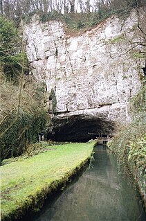
Wookey Hole Caves are a series of limestone caverns, a show cave and tourist attraction in the village of Wookey Hole on the southern edge of the Mendip Hills near Wells in Somerset, England. The River Axe flows through the cave. It is a Site of Special Scientific Interest (SSSI) for both biological and geological reasons. Wookey Hole cave is a "solutional cave", one that is formed by a process of weathering in which the natural acid in groundwater dissolves the rocks. Some water originates as rain that flows into streams on impervious rocks on the plateau before sinking at the limestone boundary into cave systems such as Swildon's Hole, Eastwater Cavern and St Cuthbert's Swallet; the rest is rain that percolates directly through the limestone. The temperature in the caves is a constant 11 °C (52 °F).

Swildons Hole Cave in Somerset, England

Swildon's Hole is an extensive cave in Priddy, Somerset. At 9,144 metres (30,000 ft) in length, it is the longest cave on the Mendip Hills. It has been found to be connected to Priddy Green Sink and forms part of the Priddy Caves Site of Special Scientific Interest (SSSI).

River Axe (Bristol Channel) River in Somerset, England

The River Axe is a river in South West England. The river is formed by water entering swallets in the limestone and rises from the ground at Wookey Hole Caves in the Mendip Hills in Somerset, and runs through a V-shaped valley. The geology of the area is limestone and the water reaches Wookey Hole in a series of underground channels that have eroded through the soluble limestone. The river mouth is in Weston Bay on the Bristol Channel.

Burrington Combe Limestone gorge in north Somerset, England

Burrington Combe is a Carboniferous Limestone gorge near the village of Burrington, on the north side of the Mendip Hills Area of Outstanding Natural Beauty, in North Somerset, England.

Lamb Leer is a 14.59 hectare geological Site of Special Scientific Interest between East Harptree and Priddy in the Mendip Hills, Somerset, notified in 1983. The cavern is a fragment of a very ancient major cave system which now contains one of the largest chambers in the Mendip Hills.

Priddy Caves is an Area: 67.6 hectare geological Site of Special Scientific Interest at Priddy in the Mendip Hills, Somerset, notified in 1965.

Priddy Pools

Priddy Pools is a 52.7-hectare (130-acre) geological Site of Special Scientific Interest at Priddy in the Mendip Hills, Somerset, notified in 1972.

Thrupe Lane Swallet is a 0.5 hectares geological Site of Special Scientific Interest in Somerset, notified in 1992. It is also a Geological Conservation Review site.

Goughs Cave Cave and archaeological site in the United Kingdom

Gough's Cave is located in Cheddar Gorge on the Mendip Hills, in Cheddar, Somerset, England. The cave is 115 m (377 ft) deep and is 3.405 km (2.12 mi) long, and contains a variety of large chambers and rock formations. It contains the Cheddar Yeo, the largest underground river system in Britain.

Caves of the Mendip Hills

The caves of the Mendip Hills are formed by the particular geology of the Mendip Hills: large areas of limestone worn away by water makes it a national centre for caving. The hills conceal the largest underground river system in Britain.

Eastwater Cavern Limestone cave in Somerset, England

Eastwater Cavern is a cave near Priddy in the limestone of the Mendip Hills, in Somerset, England. It is also known as Eastwater Swallet. It was first excavated in April 1902 by a team led by Herbert E. Balch composed of paid labourers and volunteers from the Wells Natural History Society. Progress was initially slow, but by February 1903 Balch and Willcox had discovered substantial passage, following the streamway down to the bottom of the cave. Dolphin Pot was dug in 1940 by the Wessex Cave Club, with Primrose Pot following in 1950. West End series was the most recent significant discovery, in 1983.

GB Cave Limestone cave in Somerset, England

GB Cave is a cave between Charterhouse and Shipham in the limestone of the Mendip Hills, in Somerset, England.

Goatchurch Cavern Limestone cave in Somerset, England

Goatchurch Cavern is a cave on the edge of Burrington Combe in the limestone of the Mendip Hills, in Somerset, England.

Shatter Cave Cave in Somerset, England

Shatter Cave is a cave in Fairy Cave Quarry, near Stoke St Michael in the limestone of the Mendip Hills, in Somerset, England. It falls within the St. Dunstan's Well Catchment Site of Special Scientific Interest.

Stoke Lane Slocker Limestone cave in Somerset, England

Stoke Lane Slocker is a cave near Stoke St Michael, in the Carboniferous Limestone of the Mendip Hills, in the English county of Somerset.

Sidcot Swallet is a cave near Burrington Combe, in the Carboniferous Limestone of the Mendip Hills, in Somerset, England.

Attborough Swallet is a cave in Chewton Mendip in Somerset, England.

Pierres Pot Cave in Somerset, England


Pierre's Pot is a karst cave in Burrington Combe on the Mendip Hills in Somerset, England.

Hunter's Hole is a cave in the Mendip Hills in Somerset, England. It is behind a pub, known as the Hunters Lodge Inn just outside Priddy where visitors can park. It is accessed via a permanent ladder, about 100m behind the pub in a small dip between some trees.

Charterhouse Cave, on the Mendip Hills in Somerset, is the deepest cave in southern England.

References

  1. "St Cuthbert's Swallet". Mendip Cave Registry & Archive. Retrieved 30 March 2012.
  2. 1 2 3 Irwin, David John; Knibbs, Anthony J. (1999). Mendip Underground: A Cavers Guide. Bat Products. ISBN   0-9536103-0-6. – which also contains a detailed description of the cave.
  3. "Priddy Pools" (PDF). English Nature. Retrieved 17 July 2006. In the citation this is given as St Cuthbert's Cave, which should not be confused with St Cuthbert's Cave in Northumberland.
  4. Witcombe, Richard (2009). Who was Aveline anyway?: Mendip's Cave Names Explained (2nd ed.). Priddy: Wessex Cave Club. p. 153. ISBN   978-0-9500433-6-4.
  5. Hodgkinson (Wookey Hole Paper Mill) v Ennor (St Cuthbert's Lead Works) – referenced in Irwin & Knibbs, Mendip Underground
  6. Derek C. Ford (October 1965). "The Origin of Limestone Caverns: A Model from the Central Mendip Hills, England". Bulletin of the National Speleological Society. 27 (4): 109–132. ISSN   0146-9517.
  7. "How do I book a trip to go down St Cuthberts?". Bristol Exploration Club. Retrieved 27 January 2007.
  8. "Oligaphorura schoetti in Uk and Ireland". Collembola of Britain and Ireland. Retrieved 27 January 2007.

Coordinates: 51°15′06″N2°39′15″W / 51.251777°N 2.654179°W / 51.251777; -2.654179