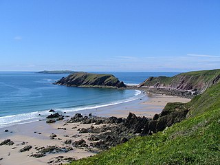
St Margaret's Island (Welsh: Ynys Farged) is a small tidal island to the northwest of Caldey Island in Carmarthen Bay, Pembrokeshire, Wales.

St Margaret's Island (Welsh: Ynys Farged) is a small tidal island to the northwest of Caldey Island in Carmarthen Bay, Pembrokeshire, Wales.
The island derives its modern (English) name from a chapel that was built there, probably in the 17th century. The island has also been known as Little Caldey. [1]
At high tide the island is separated from Caldey Island by Little Sound. There are a number of ruins on the island. There is no public access to the island; access on foot from Caldey is ill-advised. [2] Its highest point is 40 metres (130 ft) [3] and its area is 7 hectares (17 acres). [2]
The waters around the island are popular with divers.
Religious connections to the island date back to at least 1748. In Victorian times the chapel was converted into housing for local quarry workers, who mined limestone on the island, which was abandoned by 1851. The buildings subsequently fell into ruin. [4] [2] The chapel ruins and a field enclosure are recorded by the Royal Commission on Ancient monuments. [5]
Since 1950 the island has been leased from Picton Castle Estate. It is designated a Site of Special Scientific Interest. It is managed by The Wildlife Trust of South & West Wales, with management limited to monitoring seabird populations owing to difficult access. [2]
St Margaret's Island is a sensitive conservation site because of the birds that nest on its cliffs: cormorants (the largest population of this species in Wales, constituting 3% of the total British population), guillemots, razorbills, shags, kittiwakes, great black-backed gulls, lesser black-backed gulls and herring gulls. Puffins breed in rock fissures, but the existence of brown rats prevents burrow nests. [2]
Common vegetation is red fescue, common nettle, hogweed, false oat grass and cocksfoot. On seaward edges sea beet, common scurvy grass and common mallow can be seen. [2]

Pembrokeshire is a county in the south-west of Wales. It is bordered by Carmarthenshire to the east, Ceredigion to the northeast, and is otherwise surrounded by the sea. Haverfordwest is the largest town and administrative headquarters of Pembrokeshire County Council.

Skokholm or Skokholm Island is an island 2.5 miles (4.0 km) off the coast of Pembrokeshire, Wales, south of the neighbouring island of Skomer. The surrounding waters are a marine reserve and all are part of the Pembrokeshire Coast National Park. Both islands are listed as Sites of Special Scientific Interest.

Skomer or Skomer Island is an island off the coast of Pembrokeshire, in the community of Marloes and St Brides in west Wales. It is well known for its wildlife: around half the world's population of Manx shearwaters nest on the island, the Atlantic puffin colony is the largest in southern Britain, and the Skomer vole is unique to the island. Skomer is a national nature reserve, a Site of Special Scientific Interest and a Special Protection Area. It is surrounded by a marine nature reserve and is managed by the Wildlife Trust of South and West Wales.

Gateholm or Gateholm Island is a small tidal island off the south west coast of Pembrokeshire, in the community of Marloes and St Brides, in the south west side of Wales, in the west of the UK, and about 8 miles (13 km) west of the port of Milford Haven. It is known for its Romano-British remains. Gateholm is owned by the National Trust as part of their Marloes Sands and Mere estate.

Caldey Island is a small island near Tenby, Pembrokeshire, Wales, less than 1 mile (1.6 km) off the coast. With a recorded history going back over 1,500 years, it is one of the holy islands of Britain. A number of traditions inherited from Celtic times are observed by the Cistercian monks of Caldey Abbey, the owners of the island.

Merthyr Mawr is a village and community in Bridgend, Wales. The village is about 2+1⁄2 miles from the centre of Bridgend town. The population of the community at the 2011 census was 267. The community occupies the area west of the Ewenny River, between Bridgend and Porthcawl. It takes in the settlement of Tythegston and a stretch of coastal sand dunes known as Merthyr Mawr Warren. It is in the historic county of Glamorgan.

Caldey Lighthouse is located on the south end of Caldey Island, three miles (5 km) off the south Pembrokeshire, Wales coastline, a small island inhabited by a Cistercian monastery.

Annet is the second largest of the fifty or so uninhabited Isles of Scilly, 1 kilometre (0.62 mi) west of St Agnes with a length of 1 kilometre (0.62 mi) and approximately 22 hectares in area. The low-lying island is almost divided in two by a narrow neck of land at West Porth which can, at times, be covered by waves. At the northern end of the island are the two granite carns of Annet Head and Carn Irish and three smaller carns known as the Haycocks. The rocky outcrops on the southern side of the island, such as South Carn, are smaller. Annet is a bird sanctuary and the main seabird breeding site in Scilly.

Templeton is a village and community in Pembrokeshire, Wales. The population of the community was 943 in 2011. The built-up area had a population of 627.

Mohawk Island is a small island in the northeast of Lake Erie, in Haldimand County, Ontario, Canada. It is composed of limestone with almost no vegetation, and is close to the water level. It was formerly known as Gull Island and contains the ruins of the Gull Island Lighthouse which was built in 1848 to guide ships into the Welland Canal at Port Maitland. In 1933, the lighthouse was automated to no longer require a human keeper and lost significance in 1934 due to the realignment of the canal at Port Colborne. It was decommissioned in 1969 when the mechanism was destroyed by a fire. The lighthouse is located close to the shore of Rock Point Provincial Park.

Ambleston is a village, parish, and community in Pembrokeshire, Wales, lying seven miles (11 km) north-north-east of Haverfordwest. The parish includes the hamlets of Wallis and Woodstock.

Whitesands Bay is a Blue Flag beach situated on the St David's peninsula in the Pembrokeshire Coast National Park, Wales. Whitesand Bay, on some maps, located 2 miles (3.2 km) west of St. Davids and 1 mile (1.6 km) south of St Davids Head, has been described as the best surfing beach in Pembrokeshire.
Llandeilo Llwydarth or Llandilo is an ancient area and parish in the Preseli Hills between Llangolman and Maenclochog in the community of Maenclochog, Pembrokeshire, Wales.

Pill Priory is a Tironian house founded near Milford Haven, Pembrokeshire, South West Wales in the late 12th century.

Ceredigion is a large rural county in West Wales. It has a long coastline of Cardigan Bay to the west and the remote moorland of the Cambrian Mountains in the east, with the mountainous terrain of Plynlimon in the northeast. Ceredigion has a total of 264 scheduled monuments. That is too many to have on a single list page, so for convenience the list is divided into two, 163 prehistoric sites and 101 Roman, Medieval and Post Medieval sites.

Pembrokeshire is the fifth-largest county in Wales, but has more scheduled monuments (526) than any except Powys. This gives it an extremely high density of monuments, with 33.4 per 100 km2.. With three-quarters of its boundary being coastline, Pembrokeshire occupies the western end of the West Wales peninsular, terminating with the tiny cathedral city of St David's. It was a historic county in its own right but between 1975 and 1996 it joined Carmarthen and Ceredigion in the much larger county of Dyfed.

St Justinian is a coastal location of indeterminate area in the extreme northwest of Pembrokeshire, Wales, in the community of St Davids and the Cathedral Close.

Rudbaxton is a village, parish and a local government community in the county of Pembrokeshire, Wales. It is 81 miles (130 km) from Cardiff and 208 miles (335 km) from London.

Granston is a hamlet and parish in Pembrokeshire, Wales. The parish was in the Hundred of Dewisland and includes the settlements of Llangloffan and Tregwynt, with Tregwynt woollen mill. Granston is in the community of Pencaer.

Caldey Priory is a Grade I-listed priory on Caldey Island off the coast of Pembrokeshire, Wales, some 300 metres (330 yd) south of the modern Caldey Abbey. The priory gardens are listed on the Cadw/ICOMOS Register of Parks and Gardens of Special Historic Interest in Wales.