Sumay, Guam

Last updated
Sumay
US Naval Station Sumay1 Guam 930s.JPG
Sumay in the 1930s
Guam Map - NARA - 100359928 (page 2) (Sumay).jpg
Map of Sumay on Apra Harbor, 1912
USA Guam location map.svg
Red pog.svg
Sumay
Sumay on the Orote Peninsula, Guam
World location map (equirectangular 180).svg
Red pog.svg
Sumay
Sumay (Earth)
Coordinates: 13°26′13.8″N144°39′11.5″E / 13.437167°N 144.653194°E / 13.437167; 144.653194
Country United States
Territory Guam
Taking by U.S. government1948
Population
 (1941)
  Total1,997

Sumay, also Sumai, was a village on the United States territory of Guam. It was located on the north coast of the Orote Peninsula along Apra Harbor. It was inhabited by Chamorro people before contact with Europeans. Sumay became a prosperous port town serving whalers and other sailors in the 1800s and the second most populous settlement on Guam after Hagåtña, the capital of the Spanish Mariana Islands. Following the Capture of Guam by the United States in 1898, the village was the site of Marine Barracks Guam. In the early 1900s, it was a link for two firsts connecting the United States and Asia: the first submarine communications cable for telegraph and the China Clipper , the first air service. After the Japanese invasion of Guam in 1941, the residents were evicted and the village turned into a Japanese military garrison. Sumay was leveled during the U.S. liberation of the island in 1944. The U.S. military prohibited the residents from returning, relocating them to the hills of nearby Sånta Rita-Sumai. In 1948, the U.S. military exercised eminent domain and took all private and commercial property at Sumay. Its former location is now on Naval Base Guam.

Contents

History

An old cave complex at Sumay indicates that the location was inhabited prior to contact with Europeans, but is not well documented. [1] In June 1678, amid the Spanish-Chamorro Wars where Spain attempted to solidify control of the island, Governor Juan Antonio de Salas led a military column to Sumay and the nearby village of Orote, which were both considered hotbeds of anti-Spanish resistance, setting fire to homes. [2] :42 [2] :42 While the Spanish relocated much of the population into centralized villages during their rule, Sumay was allowed to continue. In 1734, Governor Francisco de Cárdenas Pacheco opened up new anchorages in Apra Harbor to better protect ships from attack. [3] Sumay eventually became a thriving port town, in particular during the height of Pacific whaling in the 1800s. [1] Following the 1856 smallpox epidemic, the survivors from Pago, as well as the Catholic mission, were transferred to Sumay. [4]

American period

Governor Willis W. Bradley at the Maxwell School in Sumay, ca. 1930 NH 985 William J. Maxwell School, Guam (cropped).jpg
Governor Willis W. Bradley at the Maxwell School in Sumay, ca. 1930

After the American Capture of Guam in 1898, Sumay continued its existence as an economically important village in a strategic location on the island. On August 7, 1899, a Naval Governorship was established [5] The Marine Barracks Guam was formally established at Sumay in 1901. [6] In 1903, the Commercial Pacific Cable Company laid submarine communications cable for telegraph through a station at Sumay, linking the United States to Asia, and each to Guam, for the first time. [1] On April 7, 1917, Marines from Sumay fired warning shots at a launch from SMS Cormoran, a German merchant raider that had been held in Apra Harbor for two years. Upon being informed that a state of war existed and that Cormoran would be confiscated, her crew scuttled her, resulting in seven deaths. [6] This incident was the first violent action of the United States in World War I, first shots fired by the U.S. against Germany in WWI, the first German prisoners of war captured by the U.S., and the first Germans killed in action by the U.S. in WWI [7] [8]

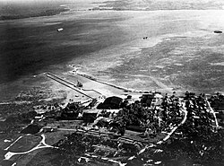
Sumay was Guam's second most populous village in the 1920 census. In 1922, dredged materials from the harbor were used to fill the coastline at Sumay and a seawall was constructed, meaning that the village no longer followed the shoreline. [1] On March 17, 1921, as the U.S. grew suspicious of Japanese intentions for its South Seas Mandate, including the Northern Mariana Islands, [9] Scouting Squadron 1 of the new United States Marine Corps Aviation, organized as Flight L out of Parris Island, arrived at Sumay. [10] :42 Comprising 10 pilots and 90 enlisted men, [9] the Marine aviators set up a shoreside base for their amphibious aircraft, which at first comprised Fairey N.9s, Curtiss HS-2Ls, and Felixstowe F.5Ls, and later Vought VE-7s and Loening OLs. The Marine Aviation unit also took detailed weather information that contributed to trans-Pacific aviation. [10] :42, 53

Guam's first golf course, Sumay Golf Links, was established in the village in 1923. [1] In response to budgetary pressures after the Wall Street Crash of 1929 and a new mood of isolationism the U.S. decided to close the seaplane base at Sumay on February 23, 1931. [9] [10] :61 The Maxwell School, named after Governor William John Maxwell, was constructed in the early 1930s. [1] In 1935, Pan American Airways established rights to use the former Marine Aviation facility and made Sumay a base for its China Clipper . The first trans-Pacific air cargo service, flying from San Francisco to Manila, arrived at Sumay on November 27, 1935 and the first passenger service flight on October 21, 1936. [11] Pan American also built Guam's first hotel in the village for its wealthy Clipper passengers in March 1936 with supplies brought by the SS North Haven. [12] [1] The 20-room Skyways Inn became a popular gathering place for island political and business leaders to mingle with guests. [11]

Destruction and taking

Imperial Japanese Navy troops mustering at the former Marine Barracks in Sumay Troops of the Imperial Japanese Navy at Guam.jpg
Imperial Japanese Navy troops mustering at the former Marine Barracks in Sumay

At least 2,000 people lived in Sumay before the Japanese invasion on December 8, 1941. Due to its strategic importance and Marine barracks, the village was the first target of Japanese bombing. [13] Governor George McMillin wrote,

Enemy planes appeared from the direction of Saipan shortly after eight o'clock, and the first bombs were dropped on the Marine Reservation and vicinity at 0827. The Marines were in the barracks, or on their normal duties throughout the post. Several were injured running across the golf course, for protection in the surrounding thickets. The Pan Air Hotel kitchen received a direct hit, and several native employees were killed. [...] Bombing continued on Tuesday, [9] December. [...] Considerable additional material damage was done at the Marine Reservation, Pan Air Installation, Standard Oil tanks (which were set on fire by bombs on Monday, [8] December) [14]

Destruction of Sumay after the 1944 Battle of Guam Ruins of Sumay, Guam in 1944 (cropped).jpg
Destruction of Sumay after the 1944 Battle of Guam

The residents of Sumay had fled during the bombing, many to a ranch named Apla at the current location of the Navy Exchange and Commissary. Many families became separated during the confusion. Several days after the surrender of American forces on December 10, 1941, the Japanese forces evicted the residents of Sumay in order to turn it into a garrison, and residents were forbidden to return without permission. Five girls from Sumay were raped during eviction. During the Japanese occupation of Guam, some Sumay residents were conscripted into constructing Orote Field, and Santa Marian Guadalupe Church was turned into a auditorium for the Japanese military. [1] In anticipation of an American attack, in July 1944 the Japanese military forced the residents of Sumay who had been living in Apla to march to the Manenggon Concentration Camp; 34 residents of Sumay and Agat were herded into caves at Fena and massacred with grenades. [1] After fierce fighting during the American recapturing of Guam, U.S. forces declared the peninsula secured on July 29, 1944. An estimated 3,000 Japanese soldiers died defending the Orote Peninsula and the village of Sumay was essentially leveled. [9]

The commanding officer of Naval Base Guam and former residents of Sumay at the old location of the village on Back to Sumay Day, 2013 130413-N-BK345-081 (8654218912).jpg
The commanding officer of Naval Base Guam and former residents of Sumay at the old location of the village on Back to Sumay Day, 2013

The U.S. military prohibited reentry to location of Sumay as Apra Harbor had become a key strategic location of the Pacific War, but residents eventually gathered at Apla, building makeshift homes as they awaited permission to return and rebuild. [1] At one point, many were allowed back to gather small items in the ruins of houses that had survived. [15] Meanwhile, Admiral Chester Nimitz requested 55% of Guam be set aside for military use, including all of Sumay. In 1945, the U.S. military gave the Sumay residents in Apla two resettlement options: to Agat or to a "temporary" refugee camp in the nearby hills of what is now Sånta Rita-Sumai, originally called just Santa Rita. Sumay residents chose the second option, moving through 1945 and 1946 to an undeveloped area with no roads, running water, or electricity. In 1946, the U.S. Congress passed Public Law 594, The Guam Acquisition of Lands Act, allowing the U.S. Navy to acquire any and all lands it deemed necessary on the island. In 1948, the military filed Civil Case No. 5-49 in the Superior Court of Guam, declaring a taking of all of Sumay, totaling 245 private and commercial plots, for little or no compensation. [1]

In 1952, the village of Santa Rita completed its church, dedicating it to Our Lady of Guadalupe, the patron saint of Sumay. Sumay residents were allowed back to their old village for the first time in 1961 to tend the graves of their relatives on All Souls' Day, a traditional Chamorro practice. [1] In 1968, Agat Park was renamed Agat-Sumay Memorial Park. [16] In 1972, the Legislature of Guam passed a resolution recognizing the suffering of the people of Sumay and a housing division in Santa Rita called New Sumay was constructed; this subdivision is now referred to as Santa Rosa or Hyundai. The Sumay Memorial Park was dedicated in 1983 on the site of the old church. [1] In 1988, the Santa Rita-Sumay Peace Memorial was erected at the former entrance to the refugee camp that residents moved to in 1945-1946. [1] In 1999, Sumay Cemetery was listed in the National Register of Historic Places [17] The cemetery, a cross from the village church, and ruins of a few structures are all that remain of the village. [1]

In modern times, the location and name of Sumay are shared with Sumay Cove Marina, which offers outdoor recreation services on Naval Base Guam. [18]

Notable residents

Related Research Articles

<span class="mw-page-title-main">Guam</span> Unincorporated US territory in the Pacific Ocean

Guam is an organized, unincorporated territory of the United States in the Micronesia subregion of the western Pacific Ocean. Guam's capital is Hagåtña, and the most populous village is Dededo. It is the westernmost point and territory of the United States, reckoned from the geographic center of the U.S. In Oceania, Guam is the largest and southernmost of the Mariana Islands and the largest island in Micronesia.

<span class="mw-page-title-main">Geography of Guam</span>

Guam is a U.S. territory in the western Pacific Ocean, at the boundary of the Philippine Sea. It is the southernmost and largest member of the Mariana Islands archipelago, which is itself the northernmost group of islands in Micronesia. The closest political entity is the Commonwealth of the Northern Mariana Islands (CNMI), another U.S. territory. Guam shares maritime boundaries with CNMI to the north and the Federated States of Micronesia to the south. It is located approximately one quarter of the way from the Philippines to Hawaii. Its location and size make it strategically important. It is the only island with both a protected harbor and land for multiple airports between Asia and Hawaii, on an east–west axis, and between Papua New Guinea and Japan, on a north–south axis.

<span class="mw-page-title-main">Apra Harbor</span> Seaport in Guam

Apra Harbor, also called Port Apra, is a deep-water port on the western side of the United States territory of Guam. It is considered one of the best natural ports in the Pacific Ocean. The harbor is bounded by Cabras Island and the Glass Breakwater to the north and the Orote Peninsula in the south. Naval Base Guam and the Port of Guam are the two major users of the harbor. It is also a popular recreation area for boaters, surfers, scuba divers, and other recreationalists.

<span class="mw-page-title-main">Hågat, Guam</span> Village in Guam, United States

Hågat is a village in the United States territory of Guam. It is located south of Apra Harbor on the island's western shore. The village's population has decreased since the island's 2010 census.

<span class="mw-page-title-main">Sånta Rita-Sumai, Guam</span> Village in Guam, United States

Sånta Rita-Sumai, formerly Santa Rita and encompassing the former municipality of Sumay, is a village located on the southwest coast of the United States territory of Guam with hills overlooking Apra Harbor. According to the 2020 census it has a population of 6,470, which is up slightly from 6,084 in 2010 but down from 11,857 in 1990. Santa Rita is the newest village in Guam, having been established after the Second World War.

<span class="mw-page-title-main">Piti, Guam</span> Village in Guam, United States

Piti is a village located on the central west coast of the United States territory of Guam. It contains northern and eastern coastlines of Apra Harbor, including Cabras Island, which has the commercial Port of Guam and the island's largest power plants. Piti was a pre-Spanish CHamoru village and, after Spanish colonization, became the primary port town on Guam. The town was largely destroyed during the 1944 liberation of Guam and the population relocated during the wartime construction of Apra Harbor.

<span class="mw-page-title-main">War in the Pacific National Historical Park</span> National Historical Park of the United States

The War in the Pacific National Historical Park is a multi-unit protected area in the United States territory of Guam, which was established in 1978 in honor of those who participated in the Pacific Theater of World War II. Uniquely among the National Park System, it honors the bravery and sacrifices of all those who participated in the Pacific Theater.

<span class="mw-page-title-main">Vicente T. Blaz</span> United States Marine Corps general

Vicente Tomás Garrido Blaz, also known as Ben Blaz, was a Chamorro United States Marine Corps Brigadier General from the United States territory of Guam. Blaz served in the Marine Corps from 1951 until July 1, 1980. Prior to his retirement, he served as the Deputy Chief of Staff for Reserve Affairs, Headquarters Marine Corps, Washington, D.C.

SMS <i>Cormoran</i> (1909) German armed merchant raider of WWI scuttled at Guam

SMS Cormoran or SMS Cormoran II was a German armed merchant raider that was originally a German-built Russian merchant vessel named Ryazan. The ship was active in the Pacific Ocean during World War I. Built in 1909, she was captured by the German light cruiser SMS Emden on 4 August 1914 and converted into a raider at the German colony Kiautschou. She was forced to seek port at Apra Harbor on the U.S. territory of Guam on 10 December 1914. The United States, then declared neutral in the war, refused to supply provisions sufficient for Cormoran to make a German port. After the U.S. declaration of war on April 6, 1917, the Naval Governor of Guam informed Cormoran that she would be seized as a hostile combatant, prompting her crew to scuttle her.

<span class="mw-page-title-main">Battle of Guam (1941)</span> WWII Battle by Japanese forces to capture Guam from the United States

The Battle of Guam was an engagement during the Pacific War in World War II, and took place from 8 December to 10 December 1941 on Guam in the Mariana Islands between Japan and the United States. The American garrison was defeated by Japanese forces on 10 December, which resulted in an occupation until the Second Battle of Guam in 1944.

<span class="mw-page-title-main">Japanese occupation of Guam</span> 1941–1944 occupation of Guam by Empire of Japan

The Japanese occupation of Guam was the period in the history of Guam between 1941 and 1944 when Imperial Japanese forces occupied Guam during World War II. The island was renamed Ōmiya-Jima.

<span class="mw-page-title-main">Orote Field</span> United States historic place

Orote Field is a former air base in the United States territory of Guam built by the Empire of Japan with Chamorro forced labor during the Japanese occupation of Guam (1941-1944). It is separate from the Marine Corps amphibious airplane base at located at Sumay village that was operational from 1921 to 1931. Following the liberation of Guam in 1944, the U.S. military repaired the field for further use in the Pacific War.

<span class="mw-page-title-main">Naval Base Guam</span> US naval base in Guam

Naval Base Guam is a strategic U.S. naval base located on Apra Harbor and occupying the Orote Peninsula. In 2009, it was combined with Andersen Air Force Base to form Joint Region Marianas, which is a Navy-controlled joint base.

<span class="mw-page-title-main">Orote Peninsula</span>

The Orote Peninsula is a four kilometer-long peninsula jutting from the west coast of the United States territory of Guam. A major geologic feature of the island, it forms the southern coast of Apra Harbor and the northern coast of Agat Bay. Its tip, Point Udall, is Guam's westernmost point and also the United States' westernmost point by travel, not longitude. The peninsula historically was the site of the important Chamorro village of Sumay, as well as Fort Santiago of the Spanish colonial period. In modern times, the peninsula is politically in the village of Santa Rita, but it is controlled in its entirety by Naval Base Guam.

<span class="mw-page-title-main">Agat Bay</span>

Agat Bay is a bay on the west coast of Guam. Its northern boundary is the Orote Peninsula, occupied entirely by Naval Base Guam, which itself lies within the village of Sånta Rita-Sumai. The bay stretches south along the coast of the village of Hågat to Facpi Point. With a length of some seven kilometers, the bay stretches for nearly one fifth of the west coast of Guam. The Asan Invasion Beach of the 1944 Battle of Guam is commemorated by the Agat Unit of War in the Pacific National Historical Park, which spans surce and subsurface areas from Apaca Point to Bangi Point. The NRHP-listed Agat World War II Amtrac is submerged off Agat Cemetery.

The Spanish–Chamorro Wars, also known as the Chamorro Wars and the Spanish–Chamorro War, refer to the late seventeenth century unrest among the Chamorros of the Mariana Islands in the western Pacific Ocean against the colonial effort of Habsburg Spain. Anger at proselytizing by the first permanent mission to Guam, which was led by Diego Luis de San Vitores, and a series of cultural misunderstandings led to increasing unrest on Guam and a Chamorro siege of the Hagåtña presidio incited by maga'låhi (Chief) Hurao in 1670. Maga'låhi Matå'pang killed San Vitores in 1672, resulting in a campaign of Spanish reprisal burnings of villages through 1676. Local anger at the attacks against villages resulted in another open rebellion led by Agualin and a second siege of Hagåtña. Governor Juan Antonio de Salas conducted a counter-insurgency campaign that successfully created a system of collaboration in which Guamanians turned in rebels and murderers and transferred most of the people from about 180 villages to seven towns, a policy known as reducción. By the early 1680s, Guam was largely "reduced," or pacified.

<span class="mw-page-title-main">Liberation Day (Guam)</span>

Liberation Day on the U.S. territory of Guam is an annual commemoration of the invasion by U.S. military forces on July 21, 1944, which ended the Japanese occupation that had begun in 1941. Begun in 1945, it is Guam's largest celebration. Festivities include a queen contest, summer carnival, fireworks display, and mile-long parade on Marine Corps Drive in Hagåtña from Adelup to Paseo de Susana, as well as solemn memorials and visits to massacre sites. It is organized by the Guam Island Fair Committee.

<span class="mw-page-title-main">Asan, Guam</span> Census-designated place in Guam, United States

Asan is a community and census-designated place (CDP) along the western coast of the U.S. territory of Guam. Asan, along with Maina and Nimitz Hill Annex, are the three communities in the village of Asan-Maina. It is known for being the location of northern invasion beach used by the United States during the retaking of Guam in 1944.

An epidemic of smallpox in 1856 on the west Pacific island of Guam, then under the control of Spain, resulted in the death of over half of the population, or about 4,500 people. The population collapse led Spanish authorities to transfer the population of Pago to Hagåtña, ending a settlement dating back before colonization. It also led the Governor of the Spanish Mariana Islands to encourage immigration to Guam.

The Fena Massacre, also known as the Fena Cave Massacre, was an event where more than 30 Chamorro people were killed by Japanese soldiers during World War II. The site is located at present-day Naval Base Guam’s Ordnance Annex in Sånta Rita-Sumai.

References

  1. 1 2 3 4 5 6 7 8 9 10 11 12 13 14 15 Babauta, Leo (October 14, 2019). "Sumay". Guampedia. Retrieved March 2, 2021.
  2. 1 2 Hezel, Francis X. (2015). When cultures clash: revisiting the 'Spanish-Chamorro Wars'. ISBN   978-1-935198-04-8 . Retrieved 19 June 2020.
  3. Haun, Daryl A. (October 10, 2019). "Fort Santiago". Guampedia. Retrieved March 2, 2021.
  4. Moore, Darlene (December 17, 2019). "Pago (Pågu)". Guampedia. Retrieved 22 April 2021.
  5. "U.S. Naval Forces, Marianas". GlobalSecurity.org. Retrieved 5 March 2021.
  6. 1 2 "History". Marine Corp Base Camp Blaz. Retrieved 5 March 2021.
  7. Conrad, Dennis (28 March 2017). "The War Begins: The United States Navy and the German Cruiser Cormoran". The Sextant. Histories and Archives Division, Naval History and Heritage Command. Retrieved 6 March 2021.
  8. Johnson, Tyler (17 October 2020). "A Rock Springs man fired the first American shot of World War I". Wyo4News. Retrieved 6 March 2021.
  9. 1 2 3 4 "Orote Air Field". U.S. National Park Service. Retrieved 2 March 2021.
  10. 1 2 3 Johnson, Edward C. (1977). Marine Corps Aviation: The Early Years, 1912-1940 (PDF) (1991 reprint ed.). Washington, DC: History and Museums Division, Headquarters USMC. Retrieved 10 March 2021.
  11. 1 2 Clement, Michael R. Jr. (October 15, 2019). "First Pan American Flights". Guampedia. Retrieved March 5, 2021.
  12. "Pan American Airways Slip & Boathouse (HAER No. GU-6)" (PDF). Historic American Engineering Record . National Park Service. 2009. Retrieved March 10, 2021.
  13. Bunn, Jennings. "WAPA - Sumay". National Park Service. Retrieved 5 March 2021.
  14. McMillin, George J. "The Defense of Guam - Surrender of Guam to the Japanese: The Report of George J. McMillin, Captain, USN". National Park Service. War in the Pacific NHP. Retrieved March 5, 2021.
  15. Babauta, Chloe (August 12, 2018). "Lost potential of Sumay, 'gem of the island'". Pacific Daily News. Retrieved 15 April 2021.
  16. "Public Law 9-213: An Act to Add Section 13404 to the Government Code of Guam to Name the Agat Park the "Agat-Sumay Memorial Park"" (PDF). Legislature of Guam. June 28, 1968. Retrieved 5 March 2021.
  17. Bunn, Jennings W. Jr. (October 8, 1999). "Sumay Cemetery NRHP Nomination". Guam Historic Preservation Office. Retrieved March 5, 2021.
  18. "Morale, Welfare and Recreation - Resources for Guam Residents". COMSUBPAC. Retrieved 6 March 2021.