
Winslow West is a census-designated place (CDP) in Navajo and Coconino counties in Arizona, United States. The population was 438 at the 2010 census. The entire community is off-reservation trust land belonging to the Hopi Tribe of Arizona. It lies just west of the city of Winslow, and is more than 50 km (31 mi) south of the main Hopi Reservation.

Riverview is a census-designated place (CDP) in Kent County, Delaware, United States. It is part of the Dover, Delaware Metropolitan Statistical Area. The population was 2,456 at the 2010 census.

Woodside East is a census-designated place (CDP) in Kent County, Delaware, United States. It is part of the Dover, Delaware Metropolitan Statistical Area. The population was 2,316 at the 2010 census.

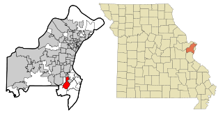
Gray Summit is an unincorporated community and census-designated place (CDP) in Franklin County, Missouri, United States. The population was 2,701 at the 2010 census. Also called "Gray's Summit", it was founded by Daniel Gray of New York, who built a hotel here in 1845. It is located on Missouri Route 100 just north of Interstate 44.
Concord is an unincorporated community and census-designated place (CDP) in St. Louis County, Missouri, United States. The population was 16,421 at the 2010 census. It should not be confused with Concord Township, which the CDP shares much land with, but these areas' boundaries are not identical.

Lake Darby is an unincorporated community and census-designated place in Franklin County, Ohio, United States, located mostly in Prairie Township and partly in Brown Township. It is more commonly known among locals as Darby Estates, which is also the name of the older housing development there, with the newer development called "West Point". As of the 2020 census, the CDP had a population of 4,731.

Portage Lakes is a census-designated place in Summit County, Ohio, United States. The population was 6,407 at the 2020 census. A suburb directly south of Akron, the community takes its name from the encompassing Portage Lakes.

West Haven-Sylvan is a census-designated place (CDP) in Washington and Multnomah counties, Oregon, United States, north of U.S. Route 26. As of the 2020 census, the CDP population was 9,299.

Franklin Township is a township in Adams County, Pennsylvania, United States. The population was 4,671 at the 2020 census.
Rouzerville is an unincorporated community and census-designated place (CDP) in Franklin County, Pennsylvania, United States. The population was 903 at the 2020 census.
Wayne Heights is a census-designated place (CDP) in Franklin County, Pennsylvania, United States. The population was 2,606 at the 2020 census.

Gloverville is a census-designated place (CDP) in Aiken County, South Carolina, United States. The population was 2,831 at the 2010 census. It is part of the Augusta, Georgia metropolitan area. Gloverville is located in historic Horse Creek Valley.
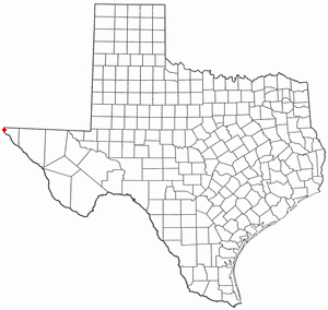
Canutillo is a census-designated place (CDP) in El Paso County, Texas, United States. The population was 6,321 at the 2010 census. It is part of the El Paso Metropolitan Statistical Area. The ZIP Codes encompassing the CDP area are 79835 and 79932.

Fort Davis is an unincorporated community and census-designated place (CDP) in Jeff Davis County, Texas, United States. The population was 1,201 at the 2010 census, up from 1,050 at the 2000 census. It is the county seat of Jeff Davis County.

Silver Summit is a census-designated place (CDP) in Summit County, Utah, United States. Prior to the 2010 Census, the area was designated as North Snyderville Basin CDP. The population was 1,821 at the 2000 census.

Woodland is a census-designated place (CDP) in Summit County, Utah, United States. The population was 335 at the 2000 census and 375 at 2020 census.

Graham is a census-designated place (CDP) in Pierce County, Washington, United States. It is located 16.2 miles southeast of Tacoma. The population was 23,491 at the 2010 census and grew to 32,658 at the 2020 census.

Midland is a census-designated place (CDP) in Pierce County, Washington. The population was 9,962 at the time of the 2020 census.

Parkland is a census-designated place (CDP) in Pierce County, Washington. The population was 35,803 at the time of the 2010 census and had grown to 38,623 as of the 2020 census. It is an unincorporated suburb of the city of Tacoma and is home to Pacific Lutheran University.

Waller is a rural census-designated place (CDP) in Pierce County, Washington, United States. The population was 8,189 at the 2020 census. The population has seen significant growth in the last decade.

