
Puget Sound is a complex estuarine system of interconnected marine waterways and basins located on the northwest coast of the U.S. state of Washington. As a part of the Salish Sea, the sound has one major and two minor connections to the Strait of Juan de Fuca, which in turn connects to the open Pacific Ocean. The major connection is Admiralty Inlet; the minor connections are Deception Pass and the Swinomish Channel.

Pierce County is a county in the U.S. state of Washington. As of the 2020 census, the population was 921,130, up from 795,225 in 2010, making it the second-most populous county in Washington, behind King County, and the 59th-most populous in the United States. The county seat and largest city is Tacoma. Formed out of Thurston County on December 22, 1852, by the legislature of Oregon Territory, it was named for U.S. President Franklin Pierce. Pierce County is in the Seattle metropolitan area.
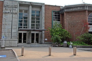
Kitsap County is a county in the U.S. state of Washington. As of the 2020 census, its population was 275,611. Its county seat is Port Orchard; its largest city is Bremerton. The county, formed out of King County and Jefferson County on January 16, 1857, is named for Chief Kitsap of the Suquamish Tribe. Originally named Slaughter County, it was soon renamed.

Gig Harbor is the name of both a bay on Puget Sound and a city on its shore in Pierce County, Washington. The population was 12,029 at the 2020 census.
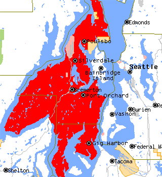
The Kitsap Peninsula lies west of Seattle across Puget Sound, in Washington state in the Pacific Northwest. Hood Canal separates the peninsula from the Olympic Peninsula on its west side. The peninsula, a.k.a. "Kitsap", encompasses all of Kitsap County except Bainbridge and Blake islands, in addition to the northeastern part of Mason County and the northwestern part of Pierce County. The highest point on the Kitsap Peninsula is Gold Mountain. The U.S. Navy's Puget Sound Naval Shipyard, and Naval Base Kitsap are on the peninsula. Its main city is Bremerton.

State Route 16 (SR 16) is a 27.16-mile-long (43.71 km) state highway in the U.S. state of Washington, connecting Pierce and Kitsap counties. The highway, signed as east–west, begins at an interchange with Interstate 5 (I-5) in Tacoma and travels through the city as a freeway towards the Tacoma Narrows. SR 16 crosses the narrows onto the Kitsap Peninsula on the partially tolled Tacoma Narrows Bridge and continues through Gig Harbor and Port Orchard before the freeway ends in Gorst. The designation ends at an intersection with SR 3 southwest of the beginning of its freeway through Bremerton and Poulsbo. SR 16 is designated as a Strategic Highway Network (STRAHNET) corridor within the National Highway System as the main thoroughfare connecting Tacoma to Naval Base Kitsap and a part of the Highways of Statewide Significance program.

Point Defiance Park in Tacoma, Washington, United States, is a large urban park. The 760-acre (3.1 km2) park includes Point Defiance Zoo & Aquarium, the Rose Garden, Rhododendron Garden, beaches, trails, a boardwalk, a boathouse, a Washington State Ferries ferry dock for the Point Defiance-Tahlequah route to Vashon Island, Fort Nisqually, an off-leash dog park, and most notably about 400 acres of old-growth forest. It receives more than three million visitors every year. Point Defiance Park is maintained and operated by Metro Parks Tacoma.

State Route 302 (SR 302) is a 16.87-mile-long (27.15 km) state highway in the U.S. state of Washington, connecting the communities of Allyn and Purdy on the Kitsap Peninsula, located in Mason and Pierce counties. The highway travels southeast from SR 3 in Allyn-Grapeview along North Bay and turns east along Henderson Bay to Purdy. SR 302 intersects its spur route and turns south, ending at an interchange with SR 16 at the north end of Gig Harbor. The highway was created during the 1964 highway renumbering to replace Secondary State Highway 14A (SSH 14A) between Allyn and Purdy.

The Key Peninsula lies along Puget Sound to the south of Kitsap Peninsula in the U.S. state of Washington. It is part of Pierce County and is bordered to the west by Case Inlet and to the east by Carr Inlet. The peninsula is approximately 16 miles (26 km) long and has two Washington State Parks.
Burley is an unincorporated community and census-designated place (CDP) in Kitsap County, Washington, United States. It is located just north of the boundary with Pierce County, about halfway between Gig Harbor to the south and Port Orchard to the north. It is located at the head of the Burley Lagoon in Henderson Bay. Burley is a residential area. The community's population stood at 2,081 at the 2020 census.
The Peninsula School District is the main school district for the city of Gig Harbor, Washington, USA and the unincorporated areas around Gig Harbor and the Key Peninsula. These areas include Artondale, Arletta, Rosedale, Purdy, Wollochet, Vaughn, Lakebay, Longbranch, Home, Wauna, Crescent Valley and the Kopachuck area.

Peninsula High School is a public high school on a hill overlooking Henderson Bay and Burley Lagoon, in Purdy, north of the city of Gig Harbor, Washington, USA. The school is part of the Peninsula School District.
The Manette Peninsula is a headland that is part of the larger Kitsap Peninsula, located on the eastern flank of the Kitsap Peninsula, in western Washington, United States.
Carr Inlet, in southern Puget Sound in the U.S. state of Washington, is an arm of water between Key Peninsula and Gig Harbor Peninsula. Its southern end is connected to the southern basin of Puget Sound. Northward, it separates McNeil Island and Fox Island. The northern end of Carr Inlet is named Henderson Bay, which feeds into Burley Lagoon.

The Purdy Bridge is a continuous reinforced concrete box girder bridge that spans 550 feet (170 m), with a central span of 190 feet (58 m), between Henderson Bay and Burley Lagoon. The bridge connects Purdy, Washington with the Purdy Sand Spit Park and Wauna, Washington.

Woodard Bay Natural Resources Conservation Area is a natural reserve in Olympia, Washington, protected under the Washington Natural Areas Program. Once an important processing facility for the logging industry, it has been designated as the Weyerhaeuser South Bay Log Dump Rural Historic Landscape. Today the area is a renowned sanctuary for a variety of birds, harbor seals, river otters, bald eagles, and a colony of bats, as well as serving as an important great blue heron rookery. A recent conservation program in the area between the State of Washington and the Nature Conservancy is the first of its kind in the country.

Burley Lagoon is a picturesque 358-acre (1.45 km2) watershed located on the Key Peninsula in the U.S. state of Washington. The Purdy Bridge and Purdy Sand Spit separate Burley Lagoon from Henderson Bay at the northern end of Carr Inlet.
The Harbor History Museum is a regional maritime and history museum in Gig Harbor, Washington. It hosts exhibits on regional culture and history, and Midway Schoolhouse, a one-room schoolhouse built in 1893 and moved to the museum's grounds in 2009. The museum won the Washington Museum Association annual Award of Project Excellence for an ongoing living history program called Midway Pioneer School Experience that leads grade-school students through a day in an early 20th century classroom.

South Puget Sound is the southern reaches of Puget Sound in Southwest Washington, in the United States' Pacific Northwest. It is one of five major basins encompassing the entire Sound, and the shallowest basin, with a mean depth of 37 meters (121 ft). Exact definitions of the region vary: the state's Department of Fish and Wildlife counts all of Puget Sound south of the Tacoma Narrows for fishing regulatory purposes. The same agency counts Mason, Jefferson, Kitsap, Pierce and Thurston Counties for wildlife management. The state's Department of Ecology defines a similar area south of Colvos Passage.


