Talasani

Last updated

Talasani
Location of Talasani
Talasani
France location map-Regions and departements-2016.svg
Red pog.svg
Talasani
Corse region location map.svg
Red pog.svg
Talasani
Coordinates: 42°24′32″N9°28′50″E / 42.4089°N 9.4806°E / 42.4089; 9.4806
Country France
Region Corsica
Department Haute-Corse
Arrondissement Corte
Canton Casinca-Fumalto
Intercommunality Costa Verde
Government
  Mayor (20202026) Francis Marcantei [1]
Area
1
10.09 km2 (3.90 sq mi)
Population
 (Jan. 2021) [2]
827
  Density82/km2 (210/sq mi)
Time zone UTC+01:00 (CET)
  Summer (DST) UTC+02:00 (CEST)
INSEE/Postal code
2B319 /20230
Elevation0–487 m (0–1,598 ft)
(avg. 392 m or 1,286 ft)
1 French Land Register data, which excludes lakes, ponds, glaciers > 1 km2 (0.386 sq mi or 247 acres) and river estuaries.

Talasani (French pronunciation: [talazani] ) is a rural commune and village on the eastern seaboard of Corsica, in the Haute-Corse department of France. The area has a very low population density and mainly comprises forests and farmland. As a coastal municipality, Talasani enforces strict urban planning provisions in order to preserve the ecological balance of the coast.

Contents

Geography

Talasani is a village on the eastern coast of Corsica, part of the canton of Casinca-Fumalto. It was once part of the piève, or religious district, of Tavagna . Today, Talasani belongs to the Communauté de Communes de la Costa Verde of Costa Verde, a microregion north of the Plaine orientale . [3]

Town planning

Typology

Due to its low population density, Talasani is designated as a rural commune according to the municipal density grid of Insee. [note 1] [4] [5] [6] [7] It belongs to the urban unit of Penta-di-Casinca, an agglomeration comprising 7 communes and 9,501 inhabitants as of 2017. [8] [9]

The commune is within the metropolitan area [note 2] of Bastia, which includes 93 communes and belongs to the category of urban areas with between 50,000 and 200,000 inhabitants. [10] [11]

The municipality bordered by the Mediterranean Sea is also a coastal municipality within the meaning of the law of 3 January 1986, known as the coastal law. [12] Specific urban planning provisions therefore apply in order to preserve natural spaces, sites, landscapes and the ecological balance of the coast. For example, this limits building outside already urbanized spaces within 100 metres (330 ft) of the coastline, or more if specified by local zoning. [13] [14]

Land use

Map of land use in Talasani, 2018. 2B319-Talasani-Sols.png
Map of land use in Talasani, 2018.

According to the European database of biophysical land use, Corine Land Cover (CLC), Talasani's land use consists mostly of forests and semi-natural environments (75.5% in 2018). This proportion has changed very little since 1990 (75.4%). The detailed breakdown in 2018 is as follows: shrub and/or herbaceous vegetation (46.6%), forests (28.9%), heterogeneous agricultural areas (12.2%), urbanized areas (8.3%), permanent crops (3.9%), artificial green spaces, non-agricultural (0.1%), maritime waters (0.1%). [15]

IGN also provides an online tool to compare the evolution over time of land use in the municipality (or in territories at different scales). Maps or aerial photos are available depicting multiple eras: the Cassini map (eighteenth century), the staff map (1820-1866), and the current period (1950 to today). [16]

Population

Historical population
YearPop.±% p.a.
1800 422    
1821 453+0.34%
1846 541+0.71%
1872 460−0.62%
1901 529+0.48%
1926 402−1.09%
1946 271−1.95%
1962 263−0.19%
YearPop.±% p.a.
1968 236−1.79%
1975 226−0.62%
1982 218−0.51%
1990 394+7.68%
1999 516+3.04%
2007 557+0.96%
2012 731+5.59%
2017 772+1.10%
Source: EHESS [17] and INSEE (1968-2017) [18]

See also

Notes

  1. According to the zoning of rural and urban municipalities published in November 2020, in application of the new definition of rurality validated on 14 November 2020 by the interministerial committee of ruralities.
  2. In October 2020, the notion of city catchment area replaced the old notion of urban area, to allow consistent comparisons with other European Union countries.

Related Research Articles

<span class="mw-page-title-main">Urban area (France)</span> Statistical area in France

An aire urbaine is an INSEE statistical concept describing a core of urban development and the extent of its commuter activity. It was replaced by the concept "functional area", which uses the same definition as Eurostat's functional urban areas, in 2020.

<span class="mw-page-title-main">Guingamp</span> Subprefecture and commune in Brittany, France

Guingamp is a commune in the Côtes-d'Armor department in Brittany in northwestern France. With a population of 7,115 as of 2020, Guingamp is one of the smallest towns in Europe to have a top-tier professional football team: En Avant Guingamp, which played in Ligue 1 from 2013 until 2019. Guingamp station is served by high speed trains to Brest, Rennes and Paris, and regional trains to Brest, Lannion, Carhaix, Paimpol and Rennes.

<span class="mw-page-title-main">Urban unit</span> A French statistical area

In France, an urban unit is a statistical area defined by INSEE, the French national statistics office, for the measurement of contiguously built-up areas. According to the INSEE definition, an "unité urbaine" is a commune alone or a grouping of communes which: a) form a single unbroken spread of urban development, with no distance between habitations greater than 200 m and b) have all together a population greater than 2,000 inhabitants. Communes not belonging to an unité urbaine are considered rural.

<span class="mw-page-title-main">Paris metropolitan area</span> French statistical area

The Paris metropolitan area is a statistical area that describes the reach of commuter movement to and from Paris, France and its surrounding suburbs.

<span class="mw-page-title-main">Nice metropolitan area</span> Metropolitan area in France

Nice metropolitan area as defined by INSEE in 2021 is the functional urban area or commuting zone of the city of Nice, southeastern France. It covers 100 communes, has 1,103,527 inhabitants (2021) and an area of 2,073 km2. It partly overlaps with the urban unit of Nice, which covers some cities, e.g. Antibes, Grasse and Cannes, that are part of the functional area Cannes-Antibes.

<span class="mw-page-title-main">Saint-Martin-de-Bavel</span> Commune in Auvergne-Rhône-Alpes, France

Saint-Martin-de-Bavel is a commune in the Ain department in eastern France.

<span class="mw-page-title-main">Vendhuile</span> Commune in Hauts-de-France, France

Vendhuile is a commune in the Aisne department in Hauts-de-France in northern France. It received the Croix de guerre for its suffering in World War I.

<span class="mw-page-title-main">Mauves</span> Commune in Auvergne-Rhône-Alpes, France

Mauves is a commune in the Ardèche department in southern France. It is about 10 km north of Valence and 75 km south of Lyon.

<span class="mw-page-title-main">Chambon, Cher</span> Commune in Centre-Val de Loire, France

Chambon is a commune in the Cher department in the Centre-Val de Loire region of France.

<span class="mw-page-title-main">Marcilly-sur-Tille</span> Commune in Bourgogne-Franche-Comté, France

Marcilly-sur-Tille is a commune in the Côte-d'Or department in eastern France.

<span class="mw-page-title-main">Maxilly-sur-Saône</span> Commune in Bourgogne-Franche-Comté, France

Maxilly-sur-Saône is a commune in the Côte-d'Or department in the Bourgogne-Franche-Comté region in eastern France. The inhabitants are called Maximilliens and Maximilliennes.

<span class="mw-page-title-main">Étrabonne</span> Commune in Bourgogne-Franche-Comté, France

Étrabonne is a commune in the Doubs department in the Bourgogne-Franche-Comté region in eastern France.

Hardanges is a French commune, located in Mayenne, Pays de la Loire, populated by 203 persons. The commune is part of the historic province of Maine (province).

<span class="mw-page-title-main">Chicourt</span> Commune in Grand Est, France

Chicourt is a commune in the Moselle department in Grand Est in north-eastern France.

<span class="mw-page-title-main">Vaux-le-Moncelot</span> Commune in Bourgogne-Franche-Comté, France

Vaux-le-Moncelot is a commune in the Haute-Saône department in the region of Bourgogne-Franche-Comté in eastern France.

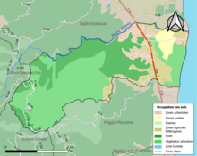
Champvoisy is a commune in the Marne department in north-eastern France. It is a rural municipality, with a very low population density. The municipality is part of the functional area of Reims, which is composed of 294 municipalities.

<span class="mw-page-title-main">Thiébauménil</span> Commune in Grand Est, France

Thiébauménil is a commune in the Meurthe-et-Moselle department in Grand Est, France.

<span class="mw-page-title-main">Breistroff-la-Grande</span> Commune in Grand Est, France

Breistroff-la-Grande is a commune in the Moselle department in Grand Est in northeastern France.

<span class="mw-page-title-main">Cherbourg-en-Cotentin</span> Subprefecture and commune in Normandy, France

Cherbourg-en-Cotentin is a port city in the department of Manche, Normandy, northwestern France, established on 1 January 2016. The commune takes its name from Cherbourg, the main town of the commune, and the Cotentin Peninsula. Cherbourg is an important commercial, ferry and military port on the English Channel. Cherbourg-en-Cotentin is a Maritime prefecture and sub-prefecture of Manche. Due to its union, it is the most populous commune in its department with 79,144 inhabitants as of 2018, making it the first city of the department before the Saint-Lô prefecture and the second in the region after Caen. Its urban unit is composed of three communes, and has 81,963 inhabitants (2018). Its larger functional area has 152,630 inhabitants (2018).

<span class="mw-page-title-main">Functional area (France)</span> Statistical area in France

An aire d'attraction d'une ville is a statistical area used by France's national statistics office INSEE since 2020, officially translated as functional area in English by INSEE, which consists of a densely populated urban agglomeration and the surrounding exurbs, towns and intervening rural areas that are socioeconomically tied to the central urban agglomeration, as measured by commuting patterns. INSEE's functional area (AAV) is therefore akin to what is most often called metropolitan area in English.

References

  1. "Répertoire national des élus: les maires". data.gouv.fr, Plateforme ouverte des données publiques françaises (in French). 2 December 2020.
  2. "Populations légales 2021". The National Institute of Statistics and Economic Studies. 28 December 2023.
  3. "Site officiel de la Communauté de Communes de la Costa Verde" (in French). Retrieved 27 November 2021.
  4. "Typologie urbain / rural | L'Observatoire des Territoires". www.observatoire-des-territoires.gouv.fr. Retrieved 24 December 2021.
  5. "Définition - Commune rurale | Insee". www.insee.fr. Retrieved 24 December 2021.
  6. "Comprendre la grille de densité | L'Observatoire des Territoires". www.observatoire-des-territoires.gouv.fr. Retrieved 24 December 2021.
  7. "Unité urbaine 2020 de Penta-di-Casinca (2B203) − COG | Insee". www.insee.fr. Retrieved 24 December 2021.
  8. "Base des unités urbaines 2020 | Insee". www.insee.fr. Retrieved 24 December 2021.
  9. "Toujours plus d'habitants dans les unités urbaines - Insee Focus - 210". www.insee.fr. Retrieved 24 December 2021.
  10. "Aire d'attraction des villes 2020 de Bastia (104) − COG | Insee". www.insee.fr. Retrieved 24 December 2021.
  11. "En France, neuf personnes sur dix vivent dans l'aire d'attraction d'une ville - Insee Focus - 211". www.insee.fr. Retrieved 24 December 2021.
  12. "Les communes soumises à la loi littoral | L'Observatoire des Territoires". www.observatoire-des-territoires.gouv.fr. Retrieved 24 December 2021.
  13. "La loi littoral | Collectivités locales" [Coastal law | Local authorities] (in French). Archived from the original on 13 April 2021. Retrieved 24 December 2021.
  14. "Loi relative à l'aménagement, la protection et la mise en valeur du littoral". Ministère de la Cohésion des territoires et des Relations avec les collectivités territoriales (in French). Retrieved 24 December 2021.
  15. "CORINE Land Cover | Données et études statistiques". www.statistiques.developpement-durable.gouv.fr. Retrieved 24 December 2021.
  16. "Remonter le temps". remonterletemps.ign.fr. Retrieved 24 December 2021.
  17. Des villages de Cassini aux communes d'aujourd'hui: Commune data sheet Talasani, EHESS (in French).
  18. Population en historique depuis 1968, INSEE