Tropical Storm Claudette (2021)

Last updated

Map key
  Tropical depression (≤38 mph, ≤62 km/h)
  Tropical storm (39–73 mph, 63–118 km/h)
  Category 1 (74–95 mph, 119–153 km/h)
  Category 2 (96–110 mph, 154–177 km/h)
  Category 3 (111–129 mph, 178–208 km/h)
  Category 4 (130–156 mph, 209–251 km/h)
  Category 5 (≥157 mph, ≥252 km/h)
  Unknown
Storm type
Disc Plain black.svg Tropical cyclone
Solid black.svg Subtropical cyclone
ArrowUp.svg Extratropical cyclone, remnant low, tropical disturbance, or monsoon depression

On June 6, a tropical wave entered the Caribbean Sea. [1] The wave briefly became convectively active before moving inland over Nicaragua and Honduras on June 10. The remnants of the system began to interact with the eastern portion of an enhanced monsoon trough in the Eastern Pacific and at 12:00 UTC on June 11, the National Hurricane Center noted the possibility of a trough of low pressure to develop in the upcoming few days over the Bay of Campeche and southwestern Gulf of Mexico. [2] The large disturbance then moved out of the Eastern Pacific into Mexico and 24 hours later, a cluster of convection formed over the Bay of Campeche and parts of Mexico and Central America. Moving erratically over the bight, the system split into two disturbances on either side of Central America, with the southern portion becoming Tropical Storm Dolores. [1] The northern disturbance gained a broad circulation on June 13 and developed an area of low pressure on June 14. After meandering in the Southern Gulf of Mexico for a couple of days, the sprawling, disorganized low began to move north-northeastward. Over the next few days, the structure of the system changed minimally due to unfavorable upper-level winds and land interaction, although convective activity occurred continuously. [3] Organization began to steadily increase east of the circulation, but a Hurricane Hunters reconnaissance aircraft investigated the system on June 17 and did not find a closed surface circulation. [4] [5] However, due to its imminent threat to land, the NHC designated the disturbance as Potential Tropical Cyclone Three at 21:00 UTC that day, and started issuing advisories on it. [6] This designation is given to tropical disturbances that have not acquired tropical cyclone status, but are likely to bring tropical storm-force or higher winds to an area, in this case the Gulf Coast of the United States, and was first used for the precursor to Tropical Storm Bret in 2017. [7] Around this time, convection was increasing and a broad curved banding feature developed on the eastern side of the storm, with the NHC describing its structure more resembled that of a subtropical cyclone. [8] Hurricane Hunters data indicated that the system was rather lopsided, with convective activity being displaced east of the ill-defined center of circulation. [1] This was due to wind shear produced by an upper-level trough over the western shore of the Gulf of Mexico. [9]

Tropical Storm Claudette over Mississippi on June 19 Claudette 2021-06-19 1900Z.jpg
Tropical Storm Claudette over Mississippi on June 19

The next day, the center reformed further north, which increased convection and adding a curvature to the lower-level clouds. [10] A hurricane hunter flight later that day confirmed the circulation had become well-defined and at 00:00 UTC on June 19, the system became a tropical storm as it already had gale-force wind. The storm had some characteristics of a subtropical storm, but was classified as sheared tropical storm since the upper-level trough responsible for its appearance was over Texas and not the storm itself. The system reached its peak intensity with winds of 50 mph (85 km/h) and a pressure of 1009 mb (29.80 inHg) as it made landfall in Terrebonne Parish, Louisiana 25 nm south-southwest of Houma at 04:30 UTC. [1] Operationally, the system was not upgraded to a tropical storm until 09:00 UTC, receiving the name Claudette, by which time it was already inland over southeastern Louisiana and weakening. [11] [12] Turning northeastward, Claudette moved into Southeastern Mississippi and weakened to a depression at 18:00 UTC. [1] After crossing the state line into Alabama, Claudette gradually turned east-northeastward and moved through North Georgia into Upstate South Carolina as a tropical depression. Deep convection increased in curved bands late on June 20, but the center was not well defined. [13] At 06:00 UTC on June 21 however, Claudette restrengthened into a tropical storm while still located over southeastern North Carolina as more organized rainbands formed along and just off the coast. Sustained winds at the time once again reached 50 mph (85 km/h), although its pressure was slightly higher this time. [1] Claudette emerged over the Western Atlantic Ocean later that day as a tropical storm while embedded within a larger low pressure envelope accelerating to east-northeast, as it began its extratropical transition. After moving into the Atlantic Ocean, Claudette moved alongside the coast of the United States and became an extratropical low at 06:00 UTC on June 22. The low continued to move northeastward, before dissipating about 100 nm southeast of the coast of Nova Scotia as it was absorbed into another extratropical storm to the west. [1]

Preparations

Waves from Claudette crashing against jetties on North Padre Island, Texas PTC3 Waves In Texas.jpg
Waves from Claudette crashing against jetties on North Padre Island, Texas

At 21:00 UTC on June 17, a Tropical Storm Warning was issued from Intracoastal City, Louisiana to the Alabama-Florida state line, including the New Orleans Metropolitan Area, Lake Pontchartrain, and Lake Maurepas, upon designation as a potential tropical cyclone. [14] The warning between Morgan City and Intracoastal City was later cancelled at 15:00 UTC on June 18. [15] Flash Flood Watches were also ordered for much of Southeast Louisiana and Mississippi between June 18–20, and also for central and southern Alabama. [16] [17] Coastal flood warnings were also posted from Intracoastal City to the Mississippi-Alabama state line. [18] In anticipation of Claudette, the Storm Prediction Center issued multiple Tornado Watches for southern Louisiana and Alabama, the Florida Panhandle and Georgia as conditions appeared favorable for tornadogenesis and embedded supercells were expected to form in the outer bands of the storm. [19] [20] Louisiana Governor John Bel Edwards issued a state of emergency for the state on June 17, banning price gouging and allowing the distribution of state-provided emergency relief. [21] Sandbag sites were opened in many parishes across Southeast Louisiana. [22] The Chevron Corporation and Occidental Petroleum removed non-essential staff and implemented severe weather protocols on their Gulf of Mexico facilities, some of which are located roughly 150 miles (240 km) offshore Louisiana. [23]

At least 90,000 sandbags were sent to coastal areas in Mississippi by the state emergency management agency, who advised residents to remain vigilant. [24] Several events, including Juneteenth events were cancelled or postponed due to the threat of Three in southern Mississippi, 2021 was the first year Juneteenth was officially a federal holiday. The De Soto National Forest shut down recreation sites near Saucier and river landings along Black Creek. [25] [26] In neighboring Alabama, construction crews had to hastily finish repairs on bulkheads in Fairhope and drainage in Downtown Mobile, the former of which was damaged by Hurricanes Sally and Zeta from the previous year. [27] The Gulf Islands National Seashore in Florida closed down Fort Pickens, issuing a mandatory evacuation for all staff and visitors of the reserve which lasted until noon on June 18. This was due to concerns of high tides pushing sand onto Fort Pickens Road, creating hostile conditions for usage. Despite this, "Opal Beach", the landfall site of Hurricane Opal, and Perdido Key remained open. [28] A total of 5–15 inches of rainfall was forecasted by the NHC on June 19 as Claudette moseyed eastward along the deep south. [29]

At 15:00 UTC on June 19, a Tropical Storm Watch was issued for North Carolina from Cape Fear to Duck. [30] [31] By 09:00 UTC the next day, a Tropical Storm Warning had been ordered from Little River Inlet, South Carolina to Duck. A Tropical Storm Watch also extended from Little River Inlet to the South Santee River in South Carolina. [32] Storm surge of up to 1–3 feet was possible from the North Carolina-Virginia border south to Little River Inlet. Heavy rain and even the potential for isolated tornadoes remained. [31]

Impact and aftermath

Mexico and Central America

The sprawling precursor to Claudette (center) and Dolores (bottom) on June 17 GOES 16 2056z 2021-06-17.jpg
The sprawling precursor to Claudette (center) and Dolores (bottom) on June 17

The Central American Gyre that later spawned Tropical Storms Claudette and Dolores caused torrential rainfall in parts of Central America and Mexico. [33] [34] Flooding began as early as June 11 and continued for nearly a week. [35] [36] Rainfall was particularly intense across Veracruz, Oaxaca, and Puebla. [37] Thirty-three municipalities in Veracruz saw significant effects, with thirteen reporting damage; at least 402 homes were damaged by flooding and landslides across the affected areas. The Isla municipality saw the most damage with 192 homes affected. Several rivers overtopped their banks, inundating surrounding communities. [36] The overflowing Pintores River in Coatepec inundated 105 homes. [38] Sinkholes occurred the city of Veracruz, Cosamaloapan between the Gloria de Coapa and Poblado Dos communities, and in Misantla. [36] [38] The Secretariat of National Defense (SEDNA) deployed personnel in Xalapa to assist in cleanup efforts. [39]

Eight municipalities in Puebla saw minimal damage from the storm, primarily limited to minor flooding and blocked roads. [40] A landslide within the Sierra Norte de Puebla briefly isolated the communities of San Agustín Altiuacan and Tlapehuala. The swollen Balsas River (locally referred to as the Atoyac River) threatened multiple bridges and submerged some homes in the Reforma Sur neighborhood. The Secretary of Civil Protection and Comprehensive Risk Management provided 24 mats and 85 blankets to affected residents in that community. [41] A localized flood in the city of Puebla affected the Museo de la Música Mexicana, the Museo Casa del Títere, and the Casa de la Música de Viena; water reached a depth of 1.6 ft (0.5 m). [42]

The combined influence of low pressure systems in the Gulf of Mexico and off the Pacific coast of Mexico led to prolonged rains in Oaxaca and Chiapas. In Oaxaca, the Chivaniza, Chapala, San Isidro, and Malatengo Rivers topped their banks and affected multiple communities. The Nisa Lubaa stream flooded 15 communities in Ixtepec, affecting more than 300 families. Two shelters were opened in the city. [43] At least ten Zapotec communities were impacted by overflowing streams and rivers, and damage to agriculture and infrastructure. The worst damage in Oaxaca was in the Sierra Sur and Costa regions, where mudslides made roads impassable. [44] Two people were killed by lightning in San Nicolás Yaxe. [43] Two people drowned in Tuxtla Gutiérrez, Chiapas, after getting out of their flooded vehicle and being sucked into a sewer. [43]

Lowland flooding in the Ciénaga 2000 subdivision of Progreso, Yucatán, prompted the evacuation of 40 people some of whom had to be rescued by boat. Two shelters were opened at schools to house displaced persons. [45] The state government provided 500 food packages to the affected residents and five water pumps to clear out standing water. [46] Street flooding occurred in Teapa, Tabasco, with several residences requiring assistance. One home was damaged in Tacotalpa by a landslide. [47] Several days of heavy rain flooded streets in Mexico City. [48] Minor flooding in Quintana Roo disrupted traffic, though overall effects were negligible. [49]

In Guatemala, heavy rains exacerbated the effects of the annual rainy season. One person was killed by a landslide in the Guatemala Department while 55,100 people were affected across the country by rains on June 14–15. [50]

United States

Tropical Storm Claudette produced light to moderate rainfall across much of the Southeastern United States, with locally heavy accumulations in Alabama, Louisiana, and Mississippi. [51] A total of 14 people died in various incidents related to the storm—4 from direct causes and 10 from indirect causes—all in Alabama. [1] [52] The National Centers for Environmental Information estimated total damage at $375 million. [1] According to AON Benfield, more than 32,500 insurance claims for storm damage were filed across the affected regions. [53]

Alabama

Severe damage caused by an EF2 tornado near East Brewton, Alabama, on June 19 June 19, 2021, East Brewton, Alabama tornado damage.jpg
Severe damage caused by an EF2 tornado near East Brewton, Alabama, on June 19

Heavy rainfall and strong thunderstorms affected much of Alabama, with the greatest precipitation occurring along two bands in the northern and southern portions of the state. The highest measured rainfall total was 6.44 in (164 mm) in northeastern Alabama, though meteorologists at the National Weather Service estimated totals may have been locally higher. [54] These rains contributed to the state producing 50 percent more hydroelectric power than expected during the month of June. [55] Flooding occurred along an area from Tuscaloosa to Birmingham to Fort Payne in conjunction with the heaviest rainfall during the overnight of June 19–20. [54] The state's Emergency Management Agency estimated 150–200 homes to be damaged. [56] Search and rescue teams were deployed to search for those who were lost in flash floods, and crews used boats in Pebble Creek to do so. [57] [58] Near Tuscaloosa, a private dam failed and the subsequent flooding washed out a water and sewer main at Nucor Corp.'s steel plant. This in turn damaged the city's sewage system, prompting officials to issue water restrictions for 100,000 people. Flooding in the city damaged or destroyed 45 homes. Damage to the sewer system alone is estimated at $1.5–4 million. [59] [60] Flooding destroyed 5 homes, severely damaged 38, and otherwise impacted a further 53 in Northport and Tuscaloosa collectively. Residential and infrastructure damage between the two cities reached $3.35 million. [61]

The strongest winds occurred in southern and coastal counties, with brief periods of sustained gales reported in Dauphin Island and Fort Morgan. A maximum gust of 49 mph (79 km/h) was measured in Point Clear. [62] Approximately 90,000 Alabama Power customers lost electricity due to downed power lines. [63] Storm surge accompanying the cyclone generally reached 1–3 ft (0.3–0.9 m), with a maxima of 3.67 ft (1.12 m) in Bayou La Batre. Surf heights on top of the surge in Mobile Bay reached 6–12 ft (1.8–3.7 m). Flooding forced the closure of roads in Bayou La Batre, Coden, and The Causeway along U.S. Route 90. [62] The Dauphin Island fishing pier sustained minor damage. [64] Three tornadoes touched down in the state: two were rated EF0 while the other was rated EF2. The former two caused minimal damage near Florala and the Cedar Point Pier in Mobile where one person was injured by debris. [62] The latter of these caused extensive damage along a 22 mi (35 km) path from East Brewton to Castleberry. [65] The tornado damaged or destroyed about 70 buildings and injured 20 people; [63] 2 people sustained serious injuries, one of whom was thrown from his home when it was destroyed. [65]

Map of rainfall accumulations from Tropical Storm Claudette across the United States Claudette 2021 rainfall map.gif
Map of rainfall accumulations from Tropical Storm Claudette across the United States

A total of 14 people died in various incidents related to the cyclone: 10 from car accidents, 2 from fallen trees, and 2 from flooding. [52] Near Cottondale, a 24-year-old man and his 3-year-old son were killed when a tree loosened by saturated soil fell on their home; winds at the time were estimated at 20–30 mph (30–50 km/h). [66] A 31-year-old man died in Birmingham after being swept away by floodwaters and a 23-year-old woman drowned after driving her car into a swollen creek in Fort Payne. [67] [68] The greatest loss of life occurred in a 17-vehicle crash—7 of which caught fire—caused by hydroplaning along I-65 in Butler County; [69] ten people died in the collisions. [70] The Butler County coroner stated the accident occurred along a downhill turn along the highway notorious for hydroplaning incidents. [71] A van carrying nine people to the Tallapoosa County Girls Ranch, a home for abused, neglected, or abandoned girls was involved in the incident. Four residents, two guests, and two of the director's children died in the crash and subsequent fire; the children killed were from ages 3 to 17. The Ranch's director survived and was hospitalized in serious condition. A 29-year-old man and his 9-month-old daughter died in another vehicle involved in the crash. [71]

Alabama Power deployed more than 200 linemen to restore service, as soon as the storm passed. Power was restored to "all customers that could safely accept it" by the evening of June 20. [63] Governor Kay Ivey declared a state of emergency for Baldwin, Butler, Cherokee, DeKalb, Escambia, Mobile, Monroe, and Tuscaloosa counties and declared East Brewton a disaster area, though federal funding would not be available pending an assessment of damage. [56] [72] [73] The Alabama Department of Revenue provided tax relief to residents and businesses the aforementioned counties. [74] In East Brewton, the American Red Cross provided food to victims and local churches provided cleanup supplies. [75] GoFundMe established a hub page for donations relating to Tropical Storm Claudette. [69] The city of Tuscaloosa approved $500,000 in funds for infrastructure repair and a further $750,000 would come from a recently implemented 1 cent sales tax. As of July 6, damage assessments across Alabama did not reach the $7.5 million threshold required for federal disaster assistance. [61] The United States Department of Agriculture provided aid to farmers and ranchers across the state. [76] Without federal aid available, the Government of Escambia County used millions of dollars of its own funds to assist relief efforts from the EF2 tornado. [77]

Florida

Strong to severe thunderstorms well to the east of Claudette's center produced damaging winds across the western Florida Panhandle. Gusts at Pensacola International Airport peaked at 81 mph (130 km/h), while a gust to 71 mph (114 km/h) was measured over the Santa Rosa Sound. Coastal areas saw brief periods of sustained tropical storm-force winds. Wind damage occurred in parts of the Pensacola metro, particularly in Ferry Pass and Pace. One home had its roof blown off. High surf of 6–12 ft (1.8–3.7 m) flooded beaches and roadways in Escambia and Santa Rosa counties. Rainfall along the Panhandle averaged 3–6 in (76–152 mm), with a peak of 6.2 in (160 mm) in Century, resulting in minor flooding. [62]

Elsewhere

Claudette produced a modest storm surge in southeastern Louisiana, owing to weaker onshore winds compared to coastal Mississippi, with peak heights generally remaining below 3 ft (0.91 m). A peak inundation of 3.2 ft (0.98 m) was measured in Shell Beach. [1] Salt water flooding remained outside of the New Orleans federal levee system. [78] Claudette's asymmetrical structure led to the strongest winds remaining east of the circulation center and away from Louisiana, despite the core itself crossing the state. Wind generally remained below tropical storm-force, [1] though some areas in Jefferson, Plaquemines, and St. Tammany parishes observed gusts above this threshold. [79] [80] [81] The greatest effects were related to heavy rainfall east of New Orleans in southeastern St. Tammany Parish. There, accumulations averaged 8 to 10 in (200 to 250 mm) with a peak observation of 11.03 in (280 mm) a few miles southeast of Slidell. [1] [79] Flash flooding in and around the community affected about 200 homes, half of which sustained minor damage. [79] Dozens of roads were closed due to high water, with at least 60 vehicles abandoned across the town, and emergency services conducted several high-water rescues. [79] [82] Damage across Slidell was regarded as the worst since Hurricane Katrina in 2005. [83]

Mississippi saw the greatest storm surge along the Gulf Coast, with a peak of 5.9 ft (1.8 m) in Bay St. Louis, which equated to a maximum inundation of 4.4 ft (1.3 m). Elsewhere in the state, surge values averaged 2 to 4 ft (0.61 to 1.22 m). Rainfall was particularly heavy in southern counties, an extension of the rainband that produced the greatest totals in Louisiana. These areas saw more than 10 in (250 mm) of rain, peaking at 15.28 in (388 mm) near Gulfport. [1] Flooding was most severe in Hancock County where approximately 100 homes were affected. High water covered dozens of roads and several people required rescue in Kiln after ignoring barricades. [84] Widespread flooding also occurred in Jackson and Pear River counties; numerous roads were shut down across both counties, two people required rescue in Pascagoula, and cars were stranded in Poplarville. [85] [86] Portions of U.S. Route 90 were rendered impassable in Biloxi and Gulfport. The Biloxi and Wolf rivers saw water reach moderate flood stage. Winds were greatest along coastal areas, with gusts reaching 60 mph (97 km/h) around Gulfport. [87] These winds caused little damage, primarily limited to downed tree branches and some power outages. [85] [87] Four tornadoes touched down in the state, one of which was rated EF1 (the other three were rated EF0), each causing relatively limited damage. [1]

Siding damage to a home from a tornado near Cuthbert, Georgia June 19, 2021, Georgia tornado damage.jpg
Siding damage to a home from a tornado near Cuthbert, Georgia

Effects from Tropical Depression Claudette in Georgia were largely limited to moderate to heavy rain, with the greatest accumulations centered near the Alabama border. Peak totals of 8 in (200 mm) were estimated in Chattooga County, resulting in localized flash flooding. Multiple roads were flooded in Summerville, including portions of State Routes 27 and 48. Some businesses were inundated and damage in the county was estimated at $75,000. [88] An EF1 tornado caused relatively minor damage, primarily relegated to snapped and uprooted trees, along a 30 mi (48 km) path across rural areas of Early, Clay, and Randolph counties. [1] [89] The rain forced the Atlanta Braves to postpone a game against the Saint Louis Cardinals. [90] Claudette traversed South Carolina as a tropical depression on June 20, bringing modest rainfall to parts of the state. Accumulations were greatest across The Midlands, with totals generally reaching 4 in (100 mm); [91] a peak of 5.71 in (145 mm) was observed in Aiken. [1] Residents in Wagener reported a funnel cloud; however, later surveys by the NWS determined it did not reach the ground. [92] As Claudette reintensified on approach to oceanfall on June 20–21, tropical storm-force winds were observed in eastern coastal communities. Sustained winds at the Isle of Palms pier reached 46 mph (74 km/h) with gusts to 62 mph (100 km/h). [1] Some trees fell onto roadways across the state. [93] Claudette had limited impact in North Carolina, with the most notable damage coming from a weak tornado near Somerset. A negligible storm surge occurred along the Pamlico Sound, peaking at 1.28 ft (0.39 m) in Oregon Inlet; surges along Atlantic-facing coastlines did not exceed 1 ft (0.30 m). Multiple coastal areas saw tropical storm-force winds, with Hatteras Island seeing sustained winds up to 46 mph (74 km/h) while rainfall peaked at 4.1 in (100 mm) near Waxhaw. [1]

Rip currents produced by the storm were felt in the Texas Coastal Bend. Three children were pulled to sea off North Padre Island and were rescued safely. [94] Minor rainfall associated with Claudette was also reported in Tennessee and Virginia. [51] Localized flash flooding occurred in southeastern Virginia, with a portion of Interstate 64 temporarily shut down. [95]

See also

Related Research Articles

<span class="mw-page-title-main">Hurricane Cindy (2005)</span> Category 1 hurricane in 2005

Hurricane Cindy was a tropical cyclone that briefly reached minimal hurricane strength in the Gulf of Mexico during July in the 2005 Atlantic hurricane season and made landfall in Louisiana. It was the third named storm and first hurricane of the season. Cindy was originally thought to have been a tropical storm at peak strength, but was upgraded to a Category 1 hurricane in the post-season analysis. Cindy formed on July 3 just east of the Yucatán Peninsula in the Caribbean Sea. The depression soon made landfall on the peninsula and weakened before reemerging in the Gulf of Mexico on July 4. The storm strengthened as it moved north becoming a hurricane just before making landfall near Grand Isle, Louisiana, on July 5. The storm weakened as it moved overland and became extratropical on July 7.

<span class="mw-page-title-main">Tropical Storm Arlene (2005)</span> Atlantic tropical storm in 2005

Tropical Storm Arlene was an unusually large and early-forming tropical storm, being the first of twenty-eight different storms during the 2005 Atlantic hurricane season, which would become the second most active season on record. Tropical Storm Arlene formed near Honduras on June 8 and moved northwards. It crossed western Cuba on June 10 and strengthened to just under hurricane strength before making its final landfall on the Florida Panhandle the next day. The storm weakened as it continued to move north over the United States, becoming extratropical on June 13. Arlene was responsible for two deaths and minor damage.

<span class="mw-page-title-main">1987 Gulf Coast tropical storm</span> Atlantic tropical storm in 1987

The 1987 Gulf Coast tropical storm caused flooding along the Gulf Coast of the United States. The second tropical cyclone and first tropical storm of the 1987 Atlantic hurricane season, it originated from a tropical wave in the Gulf of Mexico, southeast of Texas, on August 9. Initially a tropical depression, the cyclone moved north-northwestward and slightly intensified into a tropical storm later that day. By August 10, it made landfall between Galveston and Beaumont. The system weakened after moving inland and turned towards the east and later southeast. Briefly reemerging over the Gulf on August 15, the depression moved onshore a second time in Florida, before dissipating over eastern Georgia on August 17.

<span class="mw-page-title-main">Tropical Storm Fay (2008)</span> Atlantic tropical storm in 2008

Tropical Storm Fay was a strong and unusual tropical storm that moved erratically across the state of Florida and the Caribbean Sea. The sixth named storm of the 2008 Atlantic hurricane season, Fay formed from a vigorous tropical wave on August 15 over the Dominican Republic. It passed over the island of Hispaniola, into the Gulf of Gonâve, across the island of Cuba, and made landfall on the Florida Keys late in the afternoon of August 18 before veering into the Gulf of Mexico. It again made landfall near Naples, Florida, in the early hours of August 19 and progressed northeast through the Florida peninsula, emerging into the Atlantic Ocean near Melbourne on August 20. Extensive flooding took place in parts of Florida as a result of its slow movement. On August 21, it made landfall again near New Smyrna Beach, Florida, moving due west across the Panhandle, crossing Gainesville and Panama City, Florida. As it zigzagged from water to land, it became the first storm in recorded history to make landfall in Florida four times. Thirty-six deaths were blamed on Fay. The storm also resulted in one of the most prolific tropical cyclone related tornado outbreaks on record. A total of 81 tornadoes touched down across five states, three of which were rated as EF2. Damage from Fay was heavy, estimated at $560 million.

<span class="mw-page-title-main">Tropical Storm Claudette (2009)</span> Atlantic tropical storm in 2009

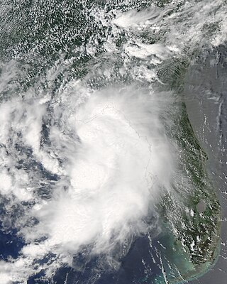
Tropical Storm Claudette was the third named storm of the 2009 Atlantic hurricane season and the first tropical cyclone of 2009 to affect the United States. Forming out of a tropical wave and an upper-level low pressure system on August 16, Claudette quickly intensified into a tropical storm offshore south of Tallahassee, Florida. By the afternoon, the storm had attained winds of 60 mph (97 km/h) and steadily tracked towards the Florida Panhandle. Early on August 17, the center of Claudette made landfall on Santa Rosa Island. Several hours after landfall, the storm weakened to a tropical depression and the Hydrometeorological Prediction Center took over primary responsibility of the storm. Later on August 17, the final public advisory was issued on the system as it dissipated over Alabama.

<span class="mw-page-title-main">Hurricane Babe</span> Category 1 Atlantic hurricane in 1977

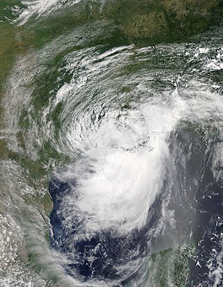
Hurricane Babe was the second named storm and the first to impact the United States during the inactive 1977 Atlantic hurricane season. Forming out of a tropical wave on September 3, Babe began as a subtropical cyclone in the eastern Gulf of Mexico. The storm gradually intensified as it tracked westward. On September 5, the storm turned north and acquired tropical characteristics. Later that day, Babe intensified into a hurricane and attained its peak strength with winds of 75 mph (120 km/h) and a barometric pressure of 995 mbar. Several hours later, the hurricane made landfall in Louisiana and quickly weakened. By September 6, Babe had weakened to a tropical depression and later dissipated early on September 9 over North Carolina.

<span class="mw-page-title-main">Tropical Storm Cindy (2017)</span> Atlantic tropical storm in 2017

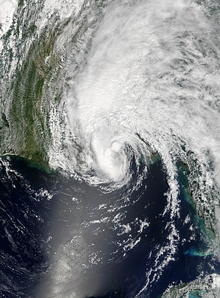
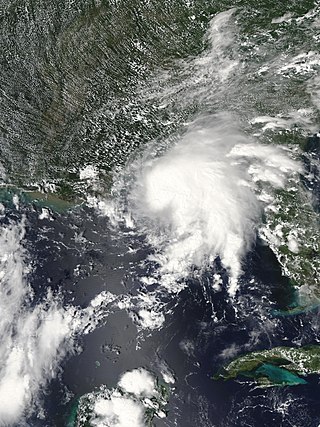
Tropical Storm Cindy was an Atlantic hurricane which became the first tropical cyclone to make landfall in Louisiana since Hurricane Isaac in 2012. The third named storm of the extremely active 2017 Atlantic hurricane season, Cindy formed out of a broad area of low pressure that developed in the northwestern Caribbean Sea near the Yucatán Peninsula in mid-June 2017. The disturbance gradually organized as it drifted northwards into the Gulf of Mexico, and was first designated as a potential tropical cyclone by the National Hurricane Center on June 19, before organizing into a tropical storm the next day. While slowly moving to the northwest, Cindy's intensification was slow due to the effects of dry air and moderate to strong wind shear. After peaking with sustained winds of 60 mph (95 km/h) on June 21, Cindy weakened slightly prior to making landfall in southwestern Louisiana on June 22. The storm quickly weakened after moving inland and degenerated into a remnant low on June 23, dissipating over the Mid-Atlantic on the following day.

<span class="mw-page-title-main">2021 Atlantic hurricane season</span> Hurricane season in the Atlantic Ocean

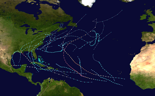
The 2021 Atlantic hurricane season was the third-most active Atlantic hurricane season on record, although many storms were weak and short-lived. With 21 named storms forming, it became the second season in a row and third overall in which the designated 21-name list of storm names was exhausted. Seven of those storms strengthened into a hurricane, four of which reached major hurricane intensity, which is slightly above-average. The season officially began on June 1 and ended on November 30. These dates historically describe the period in each year when most Atlantic tropical cyclones form. However, subtropical or tropical cyclogenesis is possible at any time of the year, as demonstrated by the development of Tropical Storm Ana on May 22, making this the seventh consecutive year in which a storm developed outside of the official season.

<span class="mw-page-title-main">Tropical Storm Gordon (2018)</span> Atlantic tropical storm in 2018

Tropical Storm Gordon was a strong tropical storm that caused damage along the Gulf Coast of the United States in early September 2018. The seventh named storm of the 2018 Atlantic hurricane season, Gordon developed from a tropical wave that was first monitored in the Caribbean Sea on August 30. The wave moved west-northwestward toward the east coast of Florida while gradually organizing. The disturbance was marked as Potential Tropical Cyclone Seven on September 2 while near the Bahamas, and early the next day, it became Tropical Storm Gordon. The system made landfall on the southwest coast of Florida shortly afterwards. Steady intensification began after it moved off the coast of Florida and into the Gulf of Mexico. Gordon reached its peak intensity as a high-end tropical storm late on September 4 before making landfall just east of Pascagoula, Mississippi shortly afterwards. Gordon then rapidly weakened as it tracked inland, and degenerated into a remnant low on September 6. Gordon's remnants lingered over Arkansas for two days, before opening up into a low-pressure trough on September 8. At least three deaths were attributed to the storm, and Gordon caused approximately $200–250 million in damages.

<span class="mw-page-title-main">Hurricane Barry (2019)</span> Category 1 Atlantic hurricane in 2019

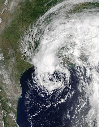
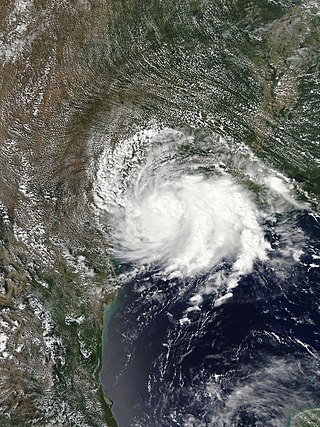
Hurricane Barry was an asymmetrical Category 1 hurricane that was the wettest tropical cyclone on record in Arkansas and the fourth-wettest in Louisiana. The second tropical or subtropical storm and first hurricane of the 2019 Atlantic hurricane season, Barry originated as a mesoscale convective vortex over southwestern Kansas on July 2. The system eventually emerged into the Gulf of Mexico from the Florida Panhandle on July 10, whereupon the National Hurricane Center (NHC) designated it as a potential tropical cyclone. Early on July 11, the system developed into a tropical depression, and strengthened into a tropical storm later that day. Dry air and wind shear caused most of the convection, or thunderstorms, to be displaced south of the center. Nevertheless, Barry gradually intensified. On July 13, Barry attained its peak intensity as Category 1 hurricane with 1-minute sustained winds of 75 mph (120 km/h) and a minimum central pressure of 993 millibars (29.3 inHg). At 15:00 UTC, Barry made its first landfall at Marsh Island, and another landfall in Intracoastal City, Louisiana, both times as a Category 1 hurricane. Barry quickly weakened after landfall, falling to tropical depression status on July 15. The storm finally degenerated into a remnant low over northern Arkansas on the same day, subsequently opening up into a trough on July 16. The storm's remnants persisted for another few days, while continuing its eastward motion, before being absorbed into another frontal storm to the south of Nova Scotia on July 19.

<span class="mw-page-title-main">Tropical Storm Imelda</span> Atlantic tropical storm in 2019

Tropical Storm Imelda was a tropical cyclone which was the fourth-wettest storm on record in the U.S. state of Texas, causing devastating and record-breaking floods in southeast Texas. The eleventh tropical cyclone and ninth named storm of the 2019 Atlantic hurricane season, Imelda formed out of an upper-level low that developed in the Gulf of Mexico and moved westward. Little development occurred until the system was near the Texas coastline, where it rapidly developed into a tropical storm before moving ashore shortly afterward on September 17. Imelda weakened after landfall, but continued bringing large amounts of flooding rain to Texas and Louisiana, before dissipating on September 21.

<span class="mw-page-title-main">Tropical Storm Bertha (2020)</span> 2020 tropical storm in the North Atlantic Ocean

Tropical Storm Bertha was a rapidly forming and short-lived off-season tropical storm that affected the Eastern United States in late May 2020. The second named storm of the very active 2020 Atlantic hurricane season, Bertha originated from a trough in the Gulf of Mexico. The National Hurricane Center (NHC) only anticipated slight development as the trough moved over southern Florida, bringing torrential rainfall. The system rapidly organized on May 27 after it emerged into the western Atlantic Ocean, developing a small, well-defined circulation. That day, the disturbance developed into Tropical Storm Bertha east of Georgia, and a few hours later it moved ashore near Isle of Palms, South Carolina with peak winds of 50 mph (80 km/h). The storm weakened over land and dissipated late on May 28 over West Virginia.

<span class="mw-page-title-main">Tropical storms Amanda and Cristobal</span> East Pacific and Atlantic tropical storms in 2020

Tropical Storm Amanda and Tropical Storm Cristobal were two related, consecutive tropical storms that affected Central America, southern Mexico, the Central United States, and Canada in late May and early June 2020. The first tropical cyclone formed in the East Pacific and was named Amanda. After crossing Central America, it regenerated into a second one in the Gulf of Mexico and was named Cristobal. Amanda was the second tropical depression and the first named storm of the 2020 Pacific hurricane season, and Cristobal was the third named storm of the extremely active 2020 Atlantic hurricane season, and the earliest third named storm in the North Atlantic Ocean on record. Cristobal's regeneration date in the North Atlantic eclipsed the date set by Tropical Storm Colin in 2016, which formed on June 5. It was also the first Atlantic tropical storm formed in the month of June since Cindy in 2017, and the first June tropical cyclone to make landfall in Mexico since Danielle in 2016.

<span class="mw-page-title-main">Hurricane Marco (2020)</span> Category 1 Atlantic hurricane in 2020

Hurricane Marco was the first of two tropical cyclones to threaten the Gulf Coast of the United States within a three-day period. The thirteenth named storm and third hurricane of the record-breaking 2020 Atlantic hurricane season, Marco developed from a fast-moving tropical wave west of the Windward Islands and south of Jamaica on August 20. The fast motion of the wave inhibited intensification initially, but as the wave slowed down and entered a more favorable environment, the system developed into a tropical depression, which in turn rapidly intensified into a strong tropical storm. Due to strong wind shear, Marco's intensification temporarily halted. However, after entering the warm waters of the Gulf of Mexico on August 23, Marco briefly intensified into a hurricane, only to quickly weaken later that evening due to another rapid increase in wind shear. Marco subsequently weakened to a tropical depression before degenerating into a remnant low early the next morning. Marco's remnants subsequently dissipated on August 26.

<span class="mw-page-title-main">Hurricane Sally</span> Category 2 Atlantic hurricane in 2020

Hurricane Sally was a destructive and slow-moving Atlantic hurricane that was the first hurricane to make landfall in the U.S. state of Alabama since Ivan in 2004, coincidentally on the same date in the same place. The eighteenth named storm and seventh hurricane of the extremely active 2020 Atlantic hurricane season, Sally developed from an area of disturbed weather which was first monitored over the Bahamas on September 10. The system grew a broad area of low-pressure on September 11, and was designated as a tropical depression late that day. Early the next day, the depression made landfall at Key Biscayne and subsequently strengthened into Tropical Storm Sally that afternoon. Moderate northwesterly shear prevented significant intensification for the first two days, but convection continued to grow towards the center and Sally slowly intensified. On September 14, a center reformation into the center of the convection occurred, and data from a hurricane hunter reconnaissance aircraft showed that Sally had rapidly intensified into a strong Category 1 hurricane. However, an increase in wind shear and upwelling of colder waters halted the intensification and Sally weakened slightly on September 15 before turning slowly northeastward. Despite this increase in wind shear, it unexpectedly re-intensified, reaching Category 2 status early on September 16 before making landfall at peak intensity at 09:45 UTC on September 16, near Gulf Shores, Alabama, with maximum sustained winds of 110 mph (180 km/h) and a minimum central pressure of 965 millibars (28.5 inHg). The storm rapidly weakened after landfall before transitioning into an extratropical low at 12:00 UTC the next day. Sally's remnants lasted for another day as they moved off the coast of the Southeastern United States before being absorbed into another extratropical storm on September 18.

<span class="mw-page-title-main">Tropical Storm Beta (2020)</span> Atlantic tropical storm in 2020

Tropical Storm Beta was a tropical cyclone that brought heavy rainfall, flooding, and severe weather to the Southeastern United States in September 2020. The twenty-third tropical depression and twenty-third named storm of the record-breaking 2020 Atlantic hurricane season, Beta originally formed from a trough of low pressure that developed in the northeastern Gulf of Mexico on September 10. The low moved slowly southwestward, with development hampered initially by the development of nearby Hurricane Sally. After Sally moved inland over the Southeastern United States and weakened, the disturbance became nearly stationary in the southwestern Gulf, where it began to organize. By September 16, the storm had gained a low-level circulation center and had enough organization to be designated as Tropical Depression Twenty-Two. The system held its intensity for a day due to the influence of strong wind shear and dry air, before eventually attaining tropical storm strength. It slowly moved northward and intensified to a mid-range tropical storm before dry air and wind shear halted its intensification. Beta then became nearly stationary on September 19, before starting to move west towards the Texas coast the next day, weakening as it approached. On September 21, Beta made landfall near Matagorda Peninsula, Texas as a minimal tropical storm. It subsequently weakened to a tropical depression the next day before becoming post-tropical early on September 23. Its remnants moved northeastward, before the center elongated and merged with a cold front early on September 25.

<span class="mw-page-title-main">Hurricane Zeta</span> Category 3 Atlantic hurricane in 2020

Hurricane Zeta was a late-season major hurricane in 2020 that made landfall on the Yucatán Peninsula and then in southeastern Louisiana, the latest on record to do so at such strength in the United States. Zeta was the record-tying sixth hurricane of the year to make landfall in the United States. The twenty-seventh named storm, twelfth hurricane and fifth major hurricane of the extremely active 2020 Atlantic hurricane season, Zeta formed from a broad area of low pressure that formed in the western Caribbean Sea on October 19. After battling wind shear, the quasi-stationary low organized into Tropical Depression Twenty-Eight on October 24. The system strengthened into Tropical Storm Zeta early on October 25 before becoming a hurricane the next day as it began to move northwestward. Hurricane Zeta made landfall on the Yucatán Peninsula late on October 26 and weakened while inland to a tropical storm, before moving off the northern coast of the peninsula on October 27. After weakening due to dry air entrainment, Zeta reorganized and became a hurricane again, and eventually a Category 2 hurricane, as it turned northeastward approaching the United States Gulf Coast on October 28. It continued to strengthen until it reached its peak intensity as a major Category 3 hurricane with 115-mile-per-hour (185 km/h) sustained winds and a minimum pressure of 970 mbar (28.64 inHg) as it made landfall at Cocodrie, Louisiana, that evening. Zeta continued on through Mississippi and parts of Alabama with hurricane-force winds. Zeta gradually weakened as it accelerated northeastward, and became post-tropical on October 29, as it moved through central Virginia, dissipating shortly afterwards off the coast of New Jersey. After bringing accumulating snow to parts of New England, the extratropical low-pressure system carrying Zeta's remnant energy impacted the United Kingdom on November 1 and 2.

<span class="mw-page-title-main">Tropical Storm Fred (2021)</span> Atlantic tropical storm in 2021

Tropical Storm Fred was a strong tropical storm which affected much of the Greater Antilles and the Southeastern United States in August 2021. The sixth tropical storm of the 2021 Atlantic hurricane season, Fred originated from a tropical wave first noted by the National Hurricane Center on August 4. As the wave drifted westward, advisories were initiated on the wave as a potential tropical cyclone by August 9 as it was approaching the Leeward Islands. Entering the Eastern Caribbean Sea after a close pass to Dominica by the next day, the potential tropical cyclone continued northwestward. By August 11, the disturbance had formed into Tropical Storm Fred just south of Puerto Rico, shortly before hitting the Dominican Republic on the island of Hispaniola later that day. The storm proceeded to weaken to a tropical depression over the highly mountainous island, before emerging north of the Windward Passage on August 12. The disorganized tropical depression turned to the west and made a second landfall in Northern Cuba on August 13. After having its circulation continuously disrupted by land interaction and wind shear, the storm degenerated into a tropical wave as it was turning northward near the western tip of Cuba the following day. Continuing north, the remnants of Fred quickly re-organized over the Gulf of Mexico, regenerating into a tropical storm by August 15. Fred continued towards the Florida Panhandle and swiftly intensified to a strong 65 mph (105 km/h) tropical storm before making landfall late on August 16 and moving into the state of Georgia. Afterward, Fred continued moving north-northeastward, before degenerating into an extratropical low on August 18. Fred's remnants later turned eastward, and the storm's remnants dissipated on August 20, near the coast of Massachusetts.

References

  1. 1 2 3 4 5 6 7 8 9 10 11 12 13 14 15 16 17 18 Papin, Philippe; Berg (January 6, 2021). Tropical Cyclone Report: Tropical Storm Claudette (AL032021) (PDF) (Report). National Hurricane Center . Retrieved January 14, 2021.
  2. Jack Beven (June 11, 2021). "Five-Day Graphical Tropical Weather Outlook". nhc.noaa.gov. Miami, Florida: National Hurricane Center. Retrieved June 21, 2021.
  3. Stacy Stewart (June 16, 2021). "Two-Day Graphical Tropical Weather Outlook". nhc.noaa.gov. Miami, Florida: National Hurricane Center. Retrieved June 21, 2021.
  4. Richard Pasch (June 17, 2021). "Two-Day Graphical Tropical Weather Outlook". nhc.noaa.gov. Miami, Florida: National Hurricane Center. Retrieved June 18, 2021.
  5. Richard Pasch (June 16, 2021). "Two-Day Graphical Tropical Weather Outlook". nhc.noaa.gov. Miami, Florida: National Hurricane Center. Retrieved June 21, 2021.
  6. Richard Pasch (June 17, 2021). "Potential Tropical Cyclone Three". Miami, Florida: National Hurricane Center. Retrieved June 18, 2021.
  7. "Update on National Hurricane Center Products and Services for 2017" (PDF). Miami, Florida: National Hurricane Center. Retrieved June 18, 2021.
  8. Michael Brennan, Richard Pasch (June 17, 2021). "Potential Tropical Cyclone Three Discussion Number 1". Miami, Florida: National Hurricane Center. Retrieved June 18, 2021.
  9. Jack Beven (June 18, 2021). "Potential Tropical Cyclone Three Discussion Number 2". Miami, Florida: National Hurricane Center. Retrieved June 18, 2021.
  10. Eric Blake (June 18, 2021). "Potential Tropical Cyclone Three Discussion Number 3". Miami, Florida: National Hurricane Center. Retrieved June 18, 2021.
  11. Eric Blake (June 19, 2021). "Tropical Storm Claudette Discussion Number 7". Miami, Florida: National Hurricane Center. Retrieved June 19, 2021.
  12. "Forming over land". WSAV-TV. June 22, 2021. Archived from the original on June 24, 2021. Retrieved June 24, 2021.
  13. Richard Pasch (June 20, 2021). "Tropical Depression Claudette Discussion Number 14". www.nhc.noaa.gov. Miami, Florida: National Hurricane Center. Retrieved June 21, 2021.
  14. Richard Pasch (June 17, 2021). "Potential Tropical Cyclone Three Forecast/Advisory Number 1". www.nhc.noaa.gov. Miami, Florida: National Hurricane Center. Retrieved June 18, 2021.
  15. Johh Cangialosi (June 20, 2021). "Potential Tropical Cyclone Three Advisory Number 4". www.nhc.noaa.gov. Miami, Florida: National Hurricane Center. Retrieved June 21, 2021.
  16. "Potential Tropical Cyclone 3 begins to move north, impacts expected for Louisiana Friday". WSDU. June 17, 2021. Retrieved June 18, 2021.
  17. Ryan Stinnett (June 18, 2021). "Flash Flooding and Isolated Tornadoes Possible this Weekend". Alabama News Network. Retrieved June 19, 2021.
  18. Mark Schleifstein (June 17, 2021). "Possible tropical storm to make landfall in Louisiana on Saturday, see warning issued". NOLA.com. Retrieved June 18, 2021.
  19. "Storm Prediction Center Tornado Watch 285". www.spc.noaa.gov. Retrieved June 19, 2021.
  20. "Storm Prediction Center Tornado Watch 284". www.spc.noaa.gov. Retrieved June 19, 2021.
  21. John Bel Edwards (June 17, 2021). "State of Emergency - Invest 92L Tropical Storm" (PDF). State of Louisiana. Retrieved June 18, 2021.
  22. "Ahead of tropical weather, here's where to get sandbags in the New Orleans area". NOLA.com. June 17, 2021. Retrieved June 18, 2021.
  23. "Oil firms evacuating Gulf of Mexico facilities ahead of brewing storm". Reuters. Houston, Texas. June 18, 2021. Retrieved June 18, 2021.
  24. Phil Helsel (June 17, 2021). "Louisiana under state of emergency as coast braces for storm in Gulf". NBC News. Retrieved June 18, 2021.
  25. "Here are all the canceled, postponed events on the MS Coast as tropical weather looms". Biloxi Sun Herald. June 17, 2021. Retrieved June 18, 2021.
  26. James Pollard (June 17, 2021). "Juneteenth Is Now a Federal Holiday. What Does That Mean for US Workers This Year?". NBC Connecticut. Retrieved June 18, 2021.
  27. Ashlyn Irons (June 17, 2021). "Crews in Fairhope wrap up projects ahead of storm". Fox 10 News. WGCL Digital Media. Retrieved June 17, 2021.
  28. "Gulf Islands National Seashore closing Fort Pickens ahead of tropical system". Pensacola News Journal. USA Today. June 17, 2021. Retrieved June 18, 2021.
  29. Jason Hanna. "Claudette weakens to a tropical depression but still drenches Gulf Coast and the Southeast". CNN. Retrieved June 20, 2021.
  30. John Cangialosi (June 19, 2021). "Tropical Storm Claudette Forecast/Advisory Number 8". National Hurricane Center. Retrieved June 20, 2021.
  31. 1 2 Aya Elamroussi and Jason Hanna. "Tropical storm warnings are in effect for North Carolina as Claudette continues across Southeast". CNN. Retrieved June 20, 2021.
  32. Eric Blake (June 20, 2021). "Tropical Depression Claudette Forecast/Advisory Number 11". National Hurricane Center. Retrieved June 20, 2021.
  33. "Tropical Storm Claudette Soaked the Southeast Before Moving Off Mid-Atlantic Coast". The Weather Channel. June 21, 2021. Retrieved July 5, 2021.
  34. Eric Blake (June 13, 2021). "Two-Day Graphical Tropical Weather Outlook". National Hurricane Center. Retrieved June 18, 2021.
  35. Danytza Flores (June 11, 2021). "Inundaciones y autos dañados tras tormenta". Diario de Xalapa (in Spanish). Retrieved August 26, 2021.
  36. 1 2 3 Itzel Molina (June 17, 2021). "33 municipios de Veracruz con daños por constantes lluvias". El Sol de Córdoba (in Spanish). Retrieved August 26, 2021.
  37. "Lluvia Deja Daños en Oaxaca, Veracruz y Puebla" (in Spanish). 24 Horas. June 15, 2021. Retrieved July 5, 2021.
  38. 1 2 Ariadna Garcia (June 15, 2021). "Lluvias causan daños... y vienen más tormentas". El Sol de Córdoba (in Spanish). Retrieved August 26, 2021.
  39. "Fuertes lluvias en Veracruz dejan daños en seis municipios; ve detalles" (in Spanish). Uno TV. June 14, 2021. Retrieved July 5, 2021.
  40. Edgar Ávila Pérez (June 14, 2021). "Ocho municipios y la capital afectados por lluvias en Puebla". El Universal (in Spanish). Retrieved August 26, 2021.
  41. Angelica Tenahua and Carlos Morales (June 14, 2021). "Lluvias provocan deslaves y daños en ocho municipios de Puebla" (in Spanish). Milenio. Retrieved August 26, 2021.
  42. Claudia Hernández (June 13, 2021). "Afectados los museos de la Música, Casa del Títere y de Viena por lluvias en Puebla". El Sol de Puebla (in Spanish). Retrieved August 26, 2021.
  43. 1 2 3 "Ríos Desbordados y Cuatro Muertos han Dejado la Lluvias en Oaxaca y Chiapas". La Silla Rota (in Spanish). June 17, 2021. Retrieved August 26, 2021.
  44. Patricia Briseño (June 17, 2021). "Lluvias en Oaxaca dejan 10 municipios afectados". Excelsior. Retrieved June 18, 2021.
  45. "Tras las fuertes lluvias en Yucatán se reportan inundaciones en Progreso". El Heraldo de Mexico (in Spanish). June 17, 2021. Retrieved August 26, 2021.
  46. "Otorga gobierno de Yucatán apoyo a damnificados por intensas lluvias" (in Spanish). Capital Mexico. June 17, 2021. Retrieved August 26, 2021.
  47. Casimiro Sánchez (June 15, 2021). "Lluvias causan estragos en Tacotalpa y Teapa". El Heraldo de Tabasco (in Spanish). Retrieved August 26, 2021.
  48. "Lluvias en CDMX dejan encharcamientos e inundaciones; activan alertas Amarilla y Naranja". El Heraldo de Mexico (in Spanish). June 13, 2021. Retrieved August 26, 2021.
  49. "Fuertes lluvias paralizan actividades en Quintana Roo, anticipan más chubascos" (in Spanish). El Punto Sobre la. June 13, 2021. Retrieved August 26, 2021.
  50. "Lluvias dejan una persona fallecida y más de 55 mil afectados". El Periódico (in Spanish). EFE. June 15, 2021. Retrieved August 26, 2021.
  51. 1 2 David Roth (August 25, 2021). "[Tropical Storm Claudette 2021 Rainfall Accumulations]" (.GIF). Weather Prediction Center. Retrieved August 26, 2021.
  52. 1 2 "Tropical Storm Claudette blamed for at least 14 deaths". CBC News. The Associated Press. June 21, 2021. Retrieved July 5, 2021.
  53. Global Catastrophe Recap July 2021 (PDF) (Report). Aon. August 11, 2021. Retrieved August 11, 2021.
  54. 1 2 "Central Alabama Impacts from Claudette June 19-20, 2021". National Weather Service Forecast Office in Birmingham, Alabama. June 2021. Retrieved July 5, 2021.
  55. White, Stacy (August 6, 2021). "Summer rains help power the state through Alabama Power hydro plants". Alabama News Center. Retrieved January 27, 2022.
  56. 1 2 Easterwood, Gabby (June 23, 2021). "Gov. Kay Ivey visits East Brewton to view tornado damage". WKRG. Retrieved July 5, 2021.
  57. "Claudette regains tropical storm status after 13 killed in Alabama". Associated Press. June 21, 2021. Retrieved June 22, 2021.
  58. "Tropical Depression Claudette claims 12 lives in Alabama". Twitter. Retrieved June 20, 2021.
  59. Morton, Jason (June 23, 2021). "Repairing storm Claudette's destruction could cost $4 million, Tuscaloosa officials say". The Tuscaloosa News. Retrieved July 5, 2021.
  60. "Tuscaloosa water, sewer pipe repairs after Claudette might cost $1.5 million". AL.com. The Associated Press. June 25, 2021. Retrieved July 5, 2021.
  61. 1 2 Phillips, Ryan (July 6, 2021). "Officials Estimate Nearly $3M In Flood Damage In Northport". Patch Media. Retrieved July 7, 2021.
  62. 1 2 3 4 "Tropical Storm Claudette - June 2021". National Weather Service Forecast Office in Mobile, Alabama. July 2021. Retrieved July 5, 2021.
  63. 1 2 3 Sharp, John (June 24, 2021). "East Brewton tornado: Power restored quickly, but search on for homeowners". AL.com. Retrieved July 5, 2021.
  64. Smith, Tandra (June 19, 2021). "Tropical Storm Claudette: Photos, video of storm damage on the coast". AL.com. Retrieved July 5, 2021.
  65. 1 2 NWS Damage Survey For 06/19/2021 East Brewton Alabama Tornado Event (Report). Iowa Environmental Mesonet. National Weather Service Forecast Office in Mobile, Alabama. June 20, 2021. Retrieved July 5, 2021.
  66. Alabama Emergency Management Agency (June 20, 2021). Preliminary Local Storm Report (Report). Iowa Environmental Mesonet. National Weather Service Forecast Office in Birmingham, Alabama. Retrieved July 5, 2021.
  67. Taylor, Derrick Bryson (June 21, 2021). "Tropical Storm Claudette Expected to Weaken After Causing Deaths and Damage". The New York Times. ISSN   0362-4331 . Retrieved June 21, 2021.
  68. "Body of man swept away in Birmingham flood found Monday is 13th storm-related death in Alabama". al. June 21, 2021. Retrieved June 24, 2021.
  69. 1 2 Robinson, Carol (June 23, 2021). "Tropical Storm Claudette: GoFundMe launches donation hub to help victims". AL.com. Retrieved July 5, 2021.
  70. "Official: Crash, "likely" due to storm, kills 10 in Alabama". Associated Press . June 20, 2021. Retrieved June 20, 2021.
  71. 1 2 Amy, Jeff; Forliti, Amy (June 21, 2021). "Youth home exec says 'words cannot explain' Alabama crash". WPLG. The Associated Press. Retrieved July 5, 2021.
  72. Taylor, Derrick Bryson (June 28, 2021). "Tropical Storm Claudette Expected to Weaken After Causing Deaths and Damage". The New York Times. Retrieved July 5, 2021.
  73. Helean, Jack (June 21, 2021). "Alabama under State of Emergency after Claudette". WTVC. Retrieved July 5, 2021.
  74. "ALDOR Announces Relief for Taxpayers Affected by Tropical Storm Claudette". Alabama Department of Revenue. June 23, 2021. Retrieved January 27, 2022.
  75. "Claudette's final tornado tally reaches seven across four states". WNCT. The Associated Press. June 22, 2021. Retrieved July 5, 2021.
  76. "USDA Assists Farmers, Ranchers, and Communities Affected by Tropical Storm Claudette" (Press release). United States Department of Agriculture. June 24, 2021. Retrieved January 27, 2022.
  77. Rupolo, John (July 19, 2021). "East Brewton high school still recovering 1 month after Tropical Storm Claudette". WEAR-TV. Retrieved January 27, 2021.
  78. [Louisiana Event Report: Storm Surge/Tide] (Report). National Centers for Environmental Information. National Weather Service Forecast Office in New Orleans, Louisiana. 2021. Retrieved January 26, 2022.
  79. 1 2 3 4 [Louisiana Event Report: Tropical Storm] (Report). National Centers for Environmental Information. National Weather Service Forecast Office in New Orleans, Louisiana. 2021. Retrieved January 26, 2022.
  80. [Louisiana Event Report: Tropical Storm] (Report). National Centers for Environmental Information. National Weather Service Forecast Office in New Orleans, Louisiana. 2021. Retrieved January 26, 2022.
  81. [Louisiana Event Report: Tropical Storm] (Report). National Centers for Environmental Information. National Weather Service Forecast Office in New Orleans, Louisiana. 2021. Retrieved January 26, 2022.
  82. Pagones, Sara; Canulette, Andrew (June 19, 2021). "A night of rude awakenings, harrowing drives as Claudette floods Slidell". NOLA.com. Retrieved January 26, 2022.
  83. Ferrando, Erika (June 21, 2021). "Clean up continues after hundreds of Slidell homes flood from Claudette". WWL. Retrieved January 26, 2022.
  84. [Mississippi Event Report: Tropical Storm] (Report). National Centers for Environmental Information. National Weather Service Forecast Office in New Orleans, Louisiana. 2021. Retrieved January 26, 2022.
  85. 1 2 [Mississippi Event Report: Tropical Storm] (Report). National Centers for Environmental Information. National Weather Service Forecast Office in New Orleans, Louisiana. 2021. Retrieved January 26, 2022.
  86. [Mississippi Event Report: Tropical Storm] (Report). National Centers for Environmental Information. National Weather Service Forecast Office in New Orleans, Louisiana. 2021. Retrieved January 26, 2022.
  87. 1 2 [Mississippi Event Report: Tropical Storm] (Report). National Centers for Environmental Information. National Weather Service Forecast Office in New Orleans, Louisiana. 2021. Retrieved January 26, 2022.
  88. [Georgia Event Report: Flash Flood] (Report). National Centers for Environmental Information. National Weather Service Forecast Office in Peachtree City, Georgia. 2021. Retrieved January 27, 2022.
  89. [Georgia Event Report: EF1 Tornado] (Report). National Centers for Environmental Information. National Weather Service Forecast Office in Tallahassee, Florida. 2021. Retrieved January 27, 2022.
  90. SATURDAY'S WEATHER-TRAFFIC: Rain moves in as Tropical Storm Claudette approaches, The Atlanta Journal Constitution, June 19, 2021
  91. [South Carolina Event Report: Tropical Depression] (Report). National Centers for Environmental Information. National Weather Service Forecast Office in Columbia, South Carolina. 2021. Retrieved January 27, 2022.
  92. [South Carolina Event Report: Funnel Cloud] (Report). National Centers for Environmental Information. National Weather Service Forecast Office in Columbia, South Carolina. 2021. Retrieved January 27, 2022.
  93. [South Carolina Event Report: Tropical Depression] (Report). National Centers for Environmental Information. National Weather Service Forecast Office in Columbia, South Carolina. 2021. Retrieved January 27, 2022.
  94. Greene, Lexis (June 20, 2021). "Tropical Depression Claudette causes high rip currents in the Coastal Bend". WIII. Retrieved January 27, 2022.
  95. [Virginia Event Report: Flash Flood] (Report). National Centers for Environmental Information. National Weather Service Forecast Office in Wakefield, Virginia. 2021. Retrieved January 27, 2022.
Tropical Storm Claudette
Claudette 2021-06-21 1740Z.jpg
Tropical Storm Claudette at its secondary peak intensity on June 21 along the North Carolina coastline