
The Dales Way is an 78.5-mile (126.3 km) long-distance footpath in Northern England, from Ilkley, West Yorkshire, to Bowness-on-Windermere, Cumbria. This walk was initially devised by the West Riding Ramblers' Association with the 'leading lights' being Colin Speakman and Tom Wilcock. The route was announced to the public in 1968 and the first recorded crossing was by a group of Bradford Grammar School Venture Scouts in 1969.

The Eden Valley Railway (EVR) was a railway in Cumbria, England. It ran between Clifton Junction near Penrith and Kirkby Stephen via Appleby-in-Westmorland.

The Esk Valley Line is a railway line located in the north of England, covering a total distance of around 30 miles (48 km), running from Middlesbrough to Whitby. The line follows the course of the River Esk for much of its eastern half.

Grosmont is a village and civil parish situated in Eskdale in the North York Moors National Park, within the boundaries of the Scarborough district of the county of North Yorkshire, England.
Brandon and Byshottles is a civil parish and electoral ward in County Durham, England. According to the 2001 census it had a population of 17,774 increasing to 18,509 at the 2011 Census. The parish includes Brandon, New Brancepeth, Broompark, Langley Moor, Ushaw Moor, Meadowfield, Waterhouses and Esh Winning.
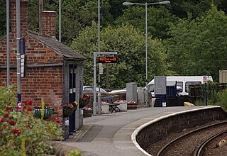
Grosmont is a railway station on the Esk Valley Line, which runs between Middlesbrough and Whitby via Nunthorpe. The station, situated 6 miles 24 chains (10.1 km) west of Whitby, serves the village of Grosmont, in the Borough of Scarborough, North Yorkshire, England. It is owned by Network Rail and managed by Northern Trains. The station is also served by heritage services operated by the North Yorkshire Moors Railway.

Clifton Moor railway station was situated in England on the Eden Valley Railway between Penrith and Kirkby Stephen East. It served the village of Clifton. The station opened to passenger traffic on 1 August 1863, and was originally named 'Clifton'. The 'Moor' suffix was added on 1 September 1927. The station finally closed on 22 January 1962.

National Cycle Route 1 is a route of the National Cycle Network, running from Dover to Tain. The 1,022 km-long (635-mile) cycle-path is located in the United Kingdom.

Aldin Grange for Bearpark railway station was located on the Lanchester Valley Railway that operated in County Durham, England. The railway station opened in 1883 as Aldin Grange, and was renamed Aldin Grange for Bearpark about a year later. In 1927 its name was changed to Bearpark. The station closed to passengers in 1939, although miners' gala excursions used the line until 1954, and freight then used the line until 1965.

Claughton is a small village and civil parish in the City of Lancaster in Lancashire, England. The village is on the A683 road east of Lancaster and at the time of the 2001 census had a population of 132. In the 2011 census Claughton was grouped with Roeburndale to give a total of 223.
Ushaw Moor is an old pit village in County Durham, in England, on the north side of the River Deerness. It is situated to the west of Durham, a short distance to the south of Bearpark. Ushaw Moor falls within the Deerness electoral ward in the City of Durham constituency, whose MP since 2019 has been Mary Foy.
The Deerness Valley Railway was an 8-mile long single track branch railway line that ran along the valley of the River Deerness in County Durham, England. Built by the North Eastern Railway, it ran from Deerness Valley Junction, on the Durham to Bishop Auckland line, to the coal mines along the valley via two intermediate stations, Waterhouses, and Ushaw Moor.

Hartshill Park is a large nature reserve stretching along the western edge of the city of Stoke-on-Trent, England. The park is a patchwork of different habitats, including five ponds. It is notable for being part of a Norman deer hunting park that has survived as open space into the modern era. It is a local nature reserve.

Waterhouses railway station, on the Deerness Valley Railway, south of the village of Esh Winning in County Durham, England, was opened on 1 November 1877 by the North Eastern Railway. The station served as the passenger terminus of the line, although goods wagons continued to East Hedley Hope and Waterhouses collieries.
Crook Hall, sited near Lanchester, County Durham, some 8 miles (13 km) north west of the city of Durham, was one of two Roman Catholic seminaries which temporarily replaced the Douai seminary in Douai, France when that college was suppressed soon after the French Revolution. Crook Hall was itself superseded after a few years by Ushaw College.
Clifton & Lowther railway station was a station on the Lancaster and Carlisle Railway (L&CR) south of Penrith near to the village of Clifton. Although it was the original terminus to cross Pennines rail traffic on the Eden Valley Railway, it was rapidly by-passed by a new line and junction. The station, which was on the West Coast Main Line, was treated as a private stop by the Earls of Lonsdale.

Filey Holiday Camp was a Butlin's holiday camp near Filey, North Yorkshire, England, built for Billy Butlin's holiday organisation. Construction of the camp began in 1939. From 1939 to 1945, the camp was used as a military training base, as RAF Hunmanby Moor. The camp closed in 1983.

Newton Dale is a narrow dale within the North York Moors National Park in North Yorkshire, England. It was created by meltwater from a glacier carving the narrow valley. Water still flows through the dale and is known as Pickering Beck.

The River Deerness in County Durham, England is a tributary to the River Browney, which is itself a tributary the River Wear. It rises near Tow Law and descends through the Deerness Valley for a distance of 11.6 miles (18.7 km), passing the villages of Waterhouses, Ushaw Moor and Esh Winning. Its confluence with the River Browney is near Langley Moor.