Varysburg, New York

Last updated

Varysburg
Founded byWilliam L. Varys

Varysburg is a village located at the intersection of U.S. Route 20A and New York State Route 98. It is in the eastern portion of the town of Sheldon close to the border with Orangeville in Wyoming County, New York, United States. As per the 2010 census the population of the Varysburg ZIP Code area (14167), which included part of the town of Orangeville, was 1,646. [1]

History

Nestled in the middle of a valley formed by the Tonawanda Creek, Varysburg was settled by William L. Vary in 1805 after purchasing the land from the Holland Land Company. William, and his extended family from Stephentown, settled the territory and hired pioneers to construct a sawmill and gristmill. [2]

Vary, who suffered a head injury in a logging accident in 1807, was named a Colonel during the War of 1812 leading a regiment sized force and was gifted a cane from Commodore Oliver Hazard Perry made out of the main mast of the USS Lawrence for his commendable service. Due to his tenure in the war, Varys became a local celebrity and opened his family farm to other settlers upon his return in 1815 which saw the settlement be incorporated as a village. Most if not all of the original settlers of the village where Baptists and formed the Free Will Baptist Church in 1816. They would be joined by a Methodist Episcopal Church in 1836. [2] [3] In 1885 Vary moved to the William L. Vary House in Livingston County.[ citation needed ]

One of the original families to move into Varysburg after it's opening by Varys was the Richards family. The patriarch of the family, Daniel Richards, was a 20 year veteran in various Vermont militias that served during the American Revolutionary War from 1777 to 1782, and moved with the family, dying in the town in 1825. On October 15, 2016, the Richards, after lobbying since 1984, unveiled a New York State Historical Marker for Daniel Richards in a ceremony with a 21 gun salute from members of the Wyoming County Joint Veterans Honor Guard dressed in Revolutionary War uniforms. [4] [5]

Starting in 1833, Varysburg, now numbering some 20 houses, came to be dominated by the Davis and Madden families who turned the village into a manufacturing hub opening Carding, Cloth, and timber mills powered by the Tonawanda Creek. Additionally, the Baptists constructed the first church in 1836, previously meeting on a rotational basis in people's homes. In 1848 the village had it's first ever murder, when John Shadbolt murdered his wife Ceonies. During the trial which took place in the Wyoming County Courthouse most of the village's adult population, some 400 to 500 individuals, attended the proceedings. The village's mills specialized in the production of shoepegs, but after a fire burned down the cloth mill in 1858, a cheese factory would be built to replace it in 1861, dominating the village's economy. [2] [3]

The opening of the cheese factory marked the beginning of the village's golden age, as the factory brought great profits to the families living in Varysburg. By 1885 there would be eight factories in Varysburg, and a number of lumber mills. In 1882 the Freemasons opened a chapter in Varysburg and a number of stores were constructed. However, in 1895 the cheese factory burned down, and by 1899 Edward Madden, the longtime owner of the "Madden Mills" and factories, would die, marking an end to the industrial prominence of the village. [2] [3]

In 1906 the Freemasons sold their temple to the Independent Order of Odd Fellows whose Lodge No. 418 continue to operate in the building until at least the 1980's. Additionally, in 1905 the village had a telephone switchboard constructed by the Bell Telephone Company. In 1908 a large fire of unknown origins burned down the western half of the village, including the village's only hotel, the Lower Hotel, and general store, the Wolf Brothers Store. Although efforts were made to rebuild the village, including the construction of the first library and garage selling ford Model-Ts in 1909, after the economic collapse from the shuttering of the factories, most residents chose to move elsewhere. [2] [3]

By 1910 most of the village was abandoned and ran the risk of becoming a ghost town until brothers Charles and John Hartung used the old buildings as a apple evaporator and bunkhouses for their employees. In 1912 the first Catholic mass was celebrated in Varysburg and a church constructed, as well as the printing of the first edition of the village's first ever newspaper, the Sheldon Democrat which would operate until it's building burned in 1921 and was sold and moved to Warsaw. In 1928 another fire broke out, this one in one of the abandoned factories, and ripped through the largely abandoned village. Most remaining buildings were destroyed and the fire was thought to have been an act of arson by George C. Mason a banker in Webster who had secretly purchased the factories just a month prior, and put in a hefty insurance premium. [2]

Related Research Articles

<span class="mw-page-title-main">Orangeville, Illinois</span> Village in Illinois, United States

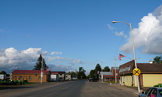
Orangeville is a village in Stephenson County, Illinois, United States. The town's sign lists the population at 800 as of January 2021. The population in 2020 was 738. The population according to the 2010 census was 793, up from 751 in 2000. Using the 2020 population of 738 Orangeville is the 741st largest city in Illinois and the 11,650th largest city in the United States. Orangeville is currently declining at a rate of -0.94% annually and its population has decreased by -6.94% since the 2010 census. The area's earliest white settlers arrived in the year 1833, and the village was platted in 1851 by John Bower, who is considered the village founder. In 1867 Orangeville was incorporated as a village. The town's central business district contains several 19th century commercial buildings, many of which were built during the railroad boom of 1888–1914. By the time the Great Depression was ongoing, business in Orangeville had started to decline, with the last bank closing in 1932. In 1956 another bank started operating in the village and is still in town today. Some recent infrastructure jumps have restored some of the village's old decor.

<span class="mw-page-title-main">Wappingers Falls, New York</span> Village in New York, United States

Wappingers Falls is a village in the towns of Poughkeepsie and Wappinger, in Dutchess County, New York, United States. As of the 2010 census it had a population of 5,522. The community was named for the cascade in Wappinger Creek. The Wappingers Falls post office covers areas in the towns of Wappinger, Poughkeepsie, Fishkill, East Fishkill, and LaGrange. This can result in some confusion when residents of the outlying towns, who do not live in the village, give their address as "Wappingers Falls".

<span class="mw-page-title-main">Bennington, New York</span> Town in New York, United States

Bennington is a town in Wyoming County, New York, United States. The population was 3,359 during the 2010 census. The town was named after Bennington, Vermont.

<span class="mw-page-title-main">Ingersoll, Ontario</span> Town in Ontario, Canada

Ingersoll is a town in Oxford County on the Thames River in southwestern Ontario, Canada. The nearest cities are Woodstock to the east and London to the west.

<span class="mw-page-title-main">Attica (village), New York</span> Village in New York, United States

Attica is a village in Wyoming and Genesee counties, New York, United States. The population was 2,547 at the 2010 census.

<span class="mw-page-title-main">Elizabethtown-Kitley</span> Township in Ontario, Canada

Elizabethtown-Kitley is a township in eastern Ontario, Canada, in the United Counties of Leeds and Grenville. Its southern border lies along the St. Lawrence River and it extends north into many rural hamlets and villages. The township was created on January 1, 2001 by the amalgamation of the former Township of Elizabethtown and Township of Kitley.

<span class="mw-page-title-main">Aultsville, Ontario</span> Ghost town in Ontario, Canada

Aultsville is a ghost town in the Canadian province of Ontario. It is one of Ontario's Lost Villages, which were permanently flooded by the creation of the St. Lawrence Seaway in 1958. The town was founded as Charlesville in 1787 by United Empire Loyalists and reached its peak in 1880, when it had 400 residents. It was the second largest town flooded by the new Seaway in 1958, with a population of 312 at the time. Before it was flooded, the abandoned buildings were burned to study the effects of fire on houses.

<span class="mw-page-title-main">Moulinette, Ontario</span> Ghost Town in Ontario, Canada

Moulinette is an underwater ghost town in the Canadian province of Ontario. It is one of Ontario's Lost Villages, which were permanently flooded by the creation of the St. Lawrence Seaway in 1958. Families and businesses in Moulinette were moved to the new town of Long Sault before the seaway construction commenced. The village was located as a strip community along Highway 2, on the St. Lawrence River. At the time of the flooding, Moulinette had a population of around 311 residents. The community would have been located in what is now South Stormont township.

<span class="mw-page-title-main">Edwardsburgh/Cardinal</span> Township in Ontario, Canada

Edwardsburgh/Cardinal is a township in the United Counties of Leeds and Grenville of eastern Ontario, Canada. Edwardsburgh township was first surveyed in 1783, and incorporated in 1850. The township was part of the historical Grenville County before it merged with Leeds County to form the United Counties in the 19th century.

<span class="mw-page-title-main">Augusta, Ontario</span> Township in Ontario, Canada

Augusta Township is a township in the United Counties of Leeds and Grenville, located in eastern Ontario, Canada. Augusta is situated along the Saint Lawrence River, and extends back into rural hamlets. The township is located between the city of Brockville to the west, and the town of Prescott to the east.

Edenvale is an unincorporated place in Springwater Township, Simcoe County, Ontario, Canada.

Shanly is an unincorporated place and Compact Rural Community in the township of Edwardsburgh/Cardinal in the United Counties of Leeds and Grenville in eastern Ontario, Canada. The village is about one hour south of Ottawa and around 7 miles north-west of Cardinal. Shanly is centred around the intersection of County Road 22, also known as Shanly Road, and County Road 21. Formerly these roads were the Nine Mile Road and the Seventh Concession, respectively. The community was settled during the 1800s, primarily as an agricultural community, and was at its height during the latter half of the 19th century, when many farms and a few businesses and factories were in operation. As of the 2000s, the rural area surrounding the main intersection consists of mostly residential properties and a few family farms. The village is also home to a few businesses and two churches.

Holmesville is a hamlet in Chenango County, New York, United States. It is situated on the Unadilla River, in the south-east corner of the town of New Berlin.

Sabin is an unincorporated community in the Town of Sylvan, Richland County, Wisconsin, United States. It is located at the intersection of County Highway E and Robbson Drive.

Bonsack is an unincorporated community in eastern Roanoke County, Virginia, United States. The community is located near the junction of US 460 and US 220 Alternate.

<span class="mw-page-title-main">Lang Pioneer Village Museum</span>

Lang Pioneer Village Museum is a living history museum located in the hamlet of Lang in Peterborough County, Ontario. It was established in 1967 by the County of Peterborough. Lang Pioneer Village is situated on the shores of the historic Indian River. Lang Pioneer Village is an "outdoor museum" featuring more than 30 restored and furnished buildings, many of which were donated from the surrounding townships. The buildings, constructed between 1820 and 1910, are interpreted by costumed villagers portraying authentic 19th-century pioneer life. Since 2014 the Museum has been the site of the Aabnaabin Encampment, a pre-colonization representation of a Michi Saagiig camp where the story of the First Nations history and culture of the region is told by indigenous interpreters. Lang Pioneer Village Museum is owned and operated by the County of Peterborough.

<span class="mw-page-title-main">Boltonville, Wisconsin</span> Unincorporated community in Wisconsin, United States

Boltonville is an unincorporated community located on Stony Creek in the town of Farmington, Washington County, Wisconsin, United States.
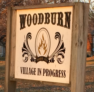
Breesport is a hamlet and census-designated place in the town of Horseheads in Chemung County, New York, United States. The population was 626 at the 2010 census.

<span class="mw-page-title-main">Johnsonville Village, Connecticut</span>

Johnsonville Village, once a thriving mill community, then a Victorian Era tourist attraction, was an abandoned ghost town in East Haddam, Connecticut, United States. On July 7, 2017, the property was acquired by the Iglesia ni Cristo, an independent, nontrinitarian Christian denomination based in the Philippines.

<span class="mw-page-title-main">Eagle Mills Township, Iredell County, North Carolina</span> Township in North Carolina, United States

Eagle Mills Township is a rural, non-functioning subdivision of Iredell County, North Carolina, United States. By the requirements of the North Carolina Constitution of 1868, the counties were divided into townships, which included Eagle Mills. Eagle Mills Township was named for the town of Eagle Mills, which was established by Andrew Baggerly on Hunting Creek in 1848.

References

  1. "Varysburg, NY City Data". MovingIdeas.org. Retrieved January 10, 2022.
  2. 1 2 3 4 5 6 Ripstein, Anita (October 1979). "A Village in the Valley". Historical Wyoming. XXVI (2).
  3. 1 2 3 4 Ripstien, Anita (January 1980). "Village in the Valley". Historical Wyoming. XXVI (3).
  4. DESMIT, SCOTT. "Marking important local history". thedailynewsonline.com. Retrieved October 4, 2023.
  5. "Daniel Richards". Historical Marker Database . Retrieved October 4, 2023.


42°44′45.37″N78°19′0.3″W / 42.7459361°N 78.316750°W / 42.7459361; -78.316750