Venetian Village, Illinois

Last updated

Venetian Village, Illinois
USA Illinois location map.svg
Red pog.svg
Venetian Village
Location in Illinois
Usa edcp location map.svg
Red pog.svg
Venetian Village
Location in the United States
Coordinates: 42°23′56″N88°3′53″W / 42.39889°N 88.06472°W / 42.39889; -88.06472
Country Flag of the United States.svg  United States
State Flag of Illinois.svg  Illinois
County Flag of Lake County, Illinois.svg Lake
Township Lake Villa
Area
[1]
  Total2.38 sq mi (6.17 km2)
  Land1.77 sq mi (4.59 km2)
  Water0.61 sq mi (1.58 km2)
Population
 (2020)
  Total2,761
  Density1,556.37/sq mi (601.00/km2)
Time zone UTC-6 (CST)
  Summer (DST) UTC-5 (CDT)
FIPS code 17-77460

Venetian Village is a census-designated place (CDP) in Lake County, Illinois, United States. Per the 2020 census, the population was 2,761. [2]

Contents

Geography

Venetian Village is located in northwestern Lake County at 42°23′56″N88°2′52″W / 42.39889°N 88.04778°W / 42.39889; -88.04778 (42.398871, -88.047845), [3] in the southeast part of Lake Villa Township. It consists of several neighborhoods adjacent to four lakes: Sand Lake, Slough Lake, Miltmore Lake, and Fourth Lake. The neighborhood of Venetian Village is in the eastern part of the CDP, while West Miltmore is in the west.

Illinois Route 83 runs along the western edge of the CDP, leading north 1 mile (1.6 km) to the center of Lake Villa and south 4 miles (6 km) to Grayslake. Illinois Route 132 passes the northern edge of Venetian Village, leading west into Lake Villa and southeast 8 miles (13 km) to Gurnee.

According to the United States Census Bureau, the CDP has a total area of 2.4 square miles (6.1 km2), of which 1.7 square miles (4.5 km2) are land and 0.6 square miles (1.6 km2), or 25.84%, are water. [4]

Demographics

Historical population
CensusPop.Note
2000 3,082
2010 2,826−8.3%
2020 2,761−2.3%
U.S. Decennial Census [5]
2010 [6] 2020 [7]

2020 census

Venetian Village CDP, Illinois – Racial and ethnic composition
(NH = Non-Hispanic)
Note: the US Census treats Hispanic/Latino as an ethnic category. This table excludes Latinos from the racial categories and assigns them to a separate category. Hispanics/Latinos may be of any race.
Race / EthnicityPop 2010 [6] Pop 2020 [7] % 2010% 2020
White alone (NH)2,5692,12890.91%77.07%
Black or African American alone (NH)21520.74%1.88%
Native American or Alaska Native alone (NH)120.04%0.07%
Asian alone (NH)34311.20%1.12%
Pacific Islander alone (NH)000.00%0.00%
Some Other Race alone (NH)580.18%0.29%
Mixed Race/Multi-Racial (NH)261070.92%3.88%
Hispanic or Latino (any race)1704336.02%15.68%
Total2,8262,761100.00%100.00%

2000 Census

As of the census [8] of 2000, there were 3,082 people, 1,119 households, and 835 families residing in the CDP. The population density was 1,274.6 inhabitants per square mile (492.1/km2). There were 1,162 housing units at an average density of 480.6 per square mile (185.6/km2). The racial makeup of the CDP was 94.78% White, 1.14% African American, 0.13% Native American, 0.81% Asian, 1.20% from other races, and 1.95% from two or more races. Hispanic or Latino of any race were 4.02% of the population.

There were 1,119 households, out of which 39.9% had children under the age of 18 living with them, 64.2% were married couples living together, 6.6% had a female householder with no husband present, and 25.3% were non-families. 20.8% of all households were made up of individuals, and 5.1% had someone living alone who was 65 years of age or older. The average household size was 2.75 and the average family size was 3.22.

In the CDP, the population was spread out, with 28.9% under the age of 18, 6.3% from 18 to 24, 35.6% from 25 to 44, 21.8% from 45 to 64, and 7.4% who were 65 years of age or older. The median age was 35 years. For every 100 females, there were 105.3 males. For every 100 females age 18 and over, there were 105.3 males.

The median income for a household in the CDP was $57,829, and the median income for a family was $61,923. Males had a median income of $41,926 versus $30,354 for females. The per capita income for the CDP was $23,504. About 1.3% of families and 3.0% of the population were below the poverty line, including none of those under age 18 and 2.2% of those age 65 or over.

Related Research Articles

<span class="mw-page-title-main">Three Lakes, Florida</span> Census-designated place in Florida

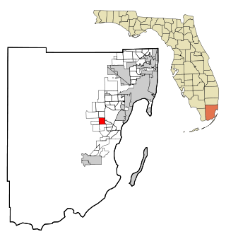
Three Lakes is a census-designated place (CDP) and planned community in Miami-Dade County, Florida, United States. It is part of the Miami metropolitan area of South Florida. The population was 16,540 at the 2020 census, up from 15,047 in 2010.

<span class="mw-page-title-main">Lake of the Woods, Illinois</span> Census-designated place in Illinois, United States

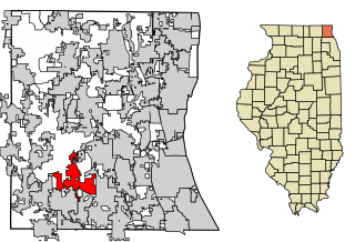
Lake of the Woods is a census-designated place (CDP) in Champaign County, Illinois, United States. The population was 2403 at the 2020 census. Lake of the Woods is in Mahomet Township and mostly surrounded by the northeast part of the village of Mahomet.

<span class="mw-page-title-main">Channel Lake, Illinois</span> Census-designated place in Illinois, United States

Channel Lake is an unincorporated community and census-designated place (CDP) in Antioch Township, Lake County, Illinois, United States. Per the 2020 census, the population was 1,581.

Forest Lake is an unincorporated community and census-designated place (CDP) in Ela Township of Lake County, Illinois, United States. It is about 35 miles (56 km) northwest of downtown Chicago. Per the 2020 census, the population was 1,784. The community was founded in 1935 as a vacation community for Chicago residents.

Fox Lake Hills is an unincorporated community and census-designated place (CDP) in Lake Villa Township, Lake County, Illinois, United States. Per the 2020 census, the population was 2,684.

Gages Lake is a census-designated place (CDP) in Warren Township, Lake County, Illinois, United States. The population was 10,637 at the 2020 census.

Grandwood Park is a census-designated place (CDP) in Warren Township, Lake County, Illinois, United States. Per the 2020 census, the population was 5,297.

<span class="mw-page-title-main">Hawthorn Woods, Illinois</span> Village in Illinois, United States

Hawthorn Woods is a village in Fremont and Ela townships in Lake County, Illinois, United States. Per the 2020 census, the population was 9,062. The village is located approximately 40 miles (60 km) northwest of downtown Chicago. Hawthorn Woods was officially incorporated in 1958. Major transportation arteries include Midlothian Road, Old McHenry Road, Algonquin Road, Half Day Road, and the Elgin, Joliet and Eastern Railway. Hawthorn Woods Country Club, whose golf course was designed by golf professional Arnold Palmer, is located within the village's perimeter.

<span class="mw-page-title-main">Island Lake, Illinois</span> Village in Illinois, United States

Island Lake is a village in Lake and McHenry counties in the U.S. state of Illinois. Per the 2020 census, the population was 8,051. The village surrounds Island Lake, a lake which contains a small island.

Lake Catherine is an unincorporated community and census-designated place (CDP) in Lake County, Illinois, United States. Per the 2020 census, the population was 1,279.

Long Lake is an unincorporated community and census-designated place (CDP) in Lake County, Illinois, United States. Per the 2020 census, the population was 3,663.

<span class="mw-page-title-main">Wadsworth, Illinois</span> Village in Illinois, United States

Wadsworth is a village in Lake County, Illinois, United States. Per the 2020 census, the population was 3,517. It is named after E. S. Wadsworth, who was a major stockholder for the Chicago, Milwaukee, St. Paul and Pacific Railroad, which passes through the village.

Pistakee Highlands is a census-designated place (CDP) in McHenry County, Illinois, United States. It consists primarily of an unincorporated area of McHenry County adjoining Pistakee Bay, within the McHenry post office, and is located just northeast of Johnsburg. Per the 2020 census, the population was 3,237.

<span class="mw-page-title-main">Fairmont, Illinois</span> Census-designated place in Illinois, United States

Fairmont is a census-designated place (CDP) in Will County, Illinois, United States. The population was 2,389 at the 2020 census.

<span class="mw-page-title-main">Frankfort Square, Illinois</span> Census-designated place in Illinois, United States

Frankfort Square is a census-designated place (CDP) in Will County, Illinois, United States. Per the 2020 census, the population was 8,968.

<span class="mw-page-title-main">Preston Heights, Illinois</span> Census-designated place in Illinois, United States

Preston Heights is a census-designated place (CDP) in Will County, Illinois, United States. As of the 2020 census, the CDP population was 2,898.

<span class="mw-page-title-main">Willow Brook Estates, Illinois</span> Census-designated place in Illinois, United States

Willow Brook Estates is an unincorporated census-designated place in Will County, Illinois, United States. The population was 1,346 at the 2020 census. it is considered a far south suburb of Chicago.

<span class="mw-page-title-main">Spanish Lake, Missouri</span> Census-designated place in Missouri, United States

Spanish Lake is a census-designated place (CDP) in St. Louis County, Missouri, United States. The population was 18,413 at the 2020 census.

<span class="mw-page-title-main">Okauchee Lake, Wisconsin</span> CDP in Wisconsin, United States

Okauchee Lake is a census-designated place (CDP) in Waukesha County, Wisconsin, United States. The population was 5,094 at the 2020 census. Okauchee Lake is located in the town of Oconomowoc.

<span class="mw-page-title-main">Tower Lakes, Illinois</span> Village in Illinois, United States

Tower Lakes is a village in Lake County, Illinois, United States. Per the 2020 census, the population was 1,226.

References

  1. "2020 U.S. Gazetteer Files". United States Census Bureau. Retrieved March 15, 2022.
  2. "Venetian Village CDP, Illinois". United States Census Bureau . Retrieved April 15, 2022.
  3. "US Gazetteer files: 2010, 2000, and 1990". United States Census Bureau. February 12, 2011. Retrieved April 23, 2011.
  4. "U.S. Gazetteer Files: 2019: Places: Illinois". U.S. Census Bureau Geography Division. Retrieved December 24, 2019.
  5. "Decennial Census of Population and Housing by Decades". US Census Bureau.
  6. 1 2 "P2 HISPANIC OR LATINO, AND NOT HISPANIC OR LATINO BY RACE – 2010: DEC Redistricting Data (PL 94-171) – Venetian Village CDP, Illinois". United States Census Bureau .
  7. 1 2 "P2 HISPANIC OR LATINO, AND NOT HISPANIC OR LATINO BY RACE – 2020: DEC Redistricting Data (PL 94-171) – Venetian Village CDP, Illinois". United States Census Bureau .
  8. "U.S. Census website". United States Census Bureau . Retrieved January 31, 2008.