Lake Villa, Illinois | |
---|---|
Motto: "Gateway to the Lake Region" [1] | |
Coordinates: 42°25′3″N88°4′56″W / 42.41750°N 88.08222°W | |
Country | United States |
State | Illinois |
County | Lake |
Government | |
• Mayor | James McDonald |
Area | |
• Total | 7.30 sq mi (18.91 km2) |
• Land | 6.52 sq mi (16.88 km2) |
• Water | 0.78 sq mi (2.03 km2) |
Population (2020) | |
• Total | 8,741 |
• Density | 1,341.47/sq mi (517.93/km2) |
Time zone | UTC-6 (CST) |
• Summer (DST) | UTC-5 (CDT) |
ZIP code | 60046 |
Area codes | 847 and 224 |
FIPS code | 17-41586 |
Wikimedia Commons | Lake Villa, Illinois |
Website | www |
Lake Villa is a village in Lake County, Illinois United States. Per the 2020 census, the population was 8,741. [3] Lake Villa lies within Lake Villa Township and about 50 miles north of Chicago and is part of the United States Census Bureau's Chicago combined statistical area (CSA).
Lake Villa is located at 42°25′3″N88°4′56″W / 42.41750°N 88.08222°W (42.417546, -88.082360). [4]
According to the 2010 census, Lake Villa has a total area of 6.994 square miles (18.11 km2), of which 6.19 square miles (16.03 km2) (or 88.5%) is land and 0.804 square miles (2.08 km2) (or 11.5%) is water. [5]
The village lies in a gently rolling moraine landscape, dominated by lakes of glacial origin known as the Chain O'Lakes. Among these are Cedar Lake, north of the village center, and Deep Lake, to the east. There are several smaller lakes and ponds, along with a complement of wetlands. The lakes and ponds have been important in Lake Villa's historic tourist industry, and over the years led to a small ice industry.
Drainage is ultimate to the Des Plaines and Fox rivers, both of which flow to the Illinois River and ultimately the Mississippi.
The Wisconsin Central Railway runs through the village center. This is a heavily used freight line which also carries Metra commuter rail traffic from Antioch, Illinois to the Chicago Loop.
Census | Pop. | Note | %± |
---|---|---|---|
1910 | 342 | — | |
1920 | 407 | 19.0% | |
1930 | 487 | 19.7% | |
1940 | 438 | −10.1% | |
1950 | 824 | 88.1% | |
1960 | 903 | 9.6% | |
1970 | 1,090 | 20.7% | |
1980 | 1,462 | 34.1% | |
1990 | 2,857 | 95.4% | |
2000 | 5,864 | 105.3% | |
2010 | 8,741 | 49.1% | |
2020 | 8,741 | 0.0% | |
U.S. Decennial Census [6] 2010 [7] 2020 [8] |
Race / Ethnicity | Pop 2010 [7] | Pop 2020 [8] | % 2010 | % 2020 |
---|---|---|---|---|
White alone (NH) | 7,109 | 6,404 | 81.33% | 73.26% |
Black or African American alone (NH) | 335 | 408 | 3.83% | 4.67% |
Native American or Alaska Native alone (NH) | 8 | 4 | 0.09% | 0.05% |
Asian alone (NH) | 437 | 534 | 5.00% | 6.11% |
Pacific Islander alone (NH) | 0 | 3 | 0.00% | 0.03% |
Some Other Race alone (NH) | 6 | 37 | 0.07% | 0.42% |
Mixed Race/Multi-Racial (NH) | 132 | 362 | 1.51% | 4.14% |
Hispanic or Latino (any race) | 714 | 989 | 8.17% | 11.31% |
Total | 8,741 | 8,741 | 100.00% | 100.00% |
As of the census [9] of 2000, there were 5,864 people, 2,052 households, and 1,594 families residing in the village. The population density was 1,024.4 inhabitants per square mile (395.5/km2). There were 2,135 housing units at an average density of 373.0 per square mile (144.0/km2). The racial makeup of the village was 92.94% White, 2.47% African American, 0.12% Native American, 1.64% Asian, 0.09% Pacific Islander, 0.89% from other races, and 1.86% from two or more races. Hispanic or Latino of any race were 3.09% of the population.
There were 2,052 households, out of which 45.1% had children under the age of 18 living with them, 67.9% were married couples living together, 7.5% had a female householder with no husband present, and 22.3% were non-families. 17.1% of all households were made up of individuals, and 6.2% had someone living alone who was 65 years of age or older. The average household size was 2.81 and the average family size was 3.20.
In the village, the population was spread out, with 32.1% under the age of 18, 5.8% from 18 to 24, 37.8% from 25 to 44, 18.9% from 45 to 64, and 5.5% who were 65 years of age or older. The median age was 33 years. For every 100 females, there were 99.4 males. For every 100 females age 18 and over, there were 94.5 males.
The median income for a household in the village was $65,078, and the median income for a family was $75,078. Males had a median income of $51,806 versus $36,961 for females. The per capita income for the village was $26,238. About 1.9% of families and 3.7% of the population were below the poverty line, including 4.7% of those under age 18 and 7.3% of those ages 65 or over.
Lake Villa has a significant Polish community, and the community has become considerably more diverse in recent years.[ citation needed ]
School districts that serve Lake Villa include but are not limited to: [10]
Lake Villa has a station on Metra's North Central Service, which provides daily rail service between Antioch and Chicago's Union Station.
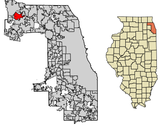
Barrington Hills is a village located about 40 miles (64 km) northwest of Chicago in the U.S. state of Illinois. Per the 2020 census, the population was 4,114. It straddles approximately 29 square miles (75 km2) over four counties, Cook, Kane, Lake, and McHenry. The Village of Barrington Hills was incorporated in 1957.
Hanover Park is a village in Cook and DuPage counties in the U.S. state of Illinois, a suburb of Chicago. The population was 37,470 at the 2020 census. Ontarioville is a neighborhood within the village.
River Forest is a suburban village adjacent to Chicago in Cook County, Illinois, United States. Per the 2020 census, the population was 11,717. Two universities make their home in River Forest, Dominican University and Concordia University Chicago. The village is closely tied to the larger neighboring community of Oak Park. There are significant architectural designs located in River Forest such as the Winslow House by Frank Lloyd Wright. River Forest has a railroad station with service to Chicago on Metra's Union Pacific West Line.
South Barrington is a residential suburb in Cook County, Illinois, United States, south of Barrington. Per the 2020 census, the population was 5,077. South Barrington is a wealthy suburb of Chicago. It is the location of the famous megachurch Willow Creek Community Church, Goebbert's Pumpkin Patch and Farm, and a lifestyle center named The Arboretum of South Barrington.
Stickney is a village in Cook County, Illinois, United States. The village is named for Alpheus Beede Stickney, a railroad executive who played a central role in establishing the Clearing Industrial District. Per the 2020 census, the population was 7,110. It was well known in the 1920s and early 1930s as the home for several bordellos linked to mobster Al Capone's empire.
Wheeling is a village in Cook and Lake counties in the U.S. state of Illinois. A suburb of Chicago, it is primarily in Cook County, approximately 23 mi (37 km) northwest of downtown Chicago. Per the 2020 census, the population was 39,137. Wheeling is named after Wheeling, West Virginia.
Willow Springs is a village in Cook County, Illinois, with a small portion in DuPage County. The village was founded in 1892, and was named for the springs along the Des Plaines River. In 2020, the population was 5,857.
Antioch is a village in Lake County, Illinois, United States. As of the 2020 census, the population was 14,622. The village is nestled into the Chain O'Lakes waterway system and borders the state of Wisconsin. Part of the Chicago metropolitan area, Antioch is located approximately halfway between the major cities of Chicago and Milwaukee.
Fox Lake is a village in Grant and Antioch townships in Lake County, Illinois and Burton Township, McHenry County, Illinois, United States. The population was 10,978 at the 2020 census. It is located approximately 57 miles north of Chicago.
Fox Lake Hills is an unincorporated community and census-designated place (CDP) in Lake Villa Township, Lake County, Illinois, United States. Per the 2020 census, the population was 2,684.
Island Lake is a village in Lake and McHenry counties in the U.S. state of Illinois. Per the 2020 census, the population was 8,051. The village surrounds Island Lake, a lake which contains a small island.
Lake Catherine is an unincorporated community and census-designated place (CDP) in Lake County, Illinois, United States. Per the 2020 census, the population was 1,279.
Lindenhurst is a village in Lake County, Illinois, United States. Per the 2020 census, the population was 14,406. Lindenhurst lies within Lake Villa Township.
Long Lake is an unincorporated community and census-designated place (CDP) in Lake County, Illinois, United States. Per the 2020 census, the population was 3,663.
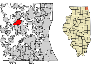
Mundelein is a village in Lake County, Illinois, United States and a northern suburb of Chicago. Per the 2020 census, the population was 31,560. It is approximately thirty-five miles northwest of Chicago.
Round Lake Beach is a northern suburb of Chicago in Lake County, Illinois, United States. Per the 2020 census, the population was 27,252.
Venetian Village is a census-designated place (CDP) in Lake County, Illinois, United States. Per the 2020 census, the population was 2,761.
Oakwood Hills is a village in McHenry County, Illinois, United States. It was founded in 1959. The population was 2,076 at the 2020 census.
Prairie Grove is a village in McHenry County, Illinois, United States, first incorporated in 1973. Per the 2020 census, the population was 1,963.
Wonder Lake is a village in McHenry County, Illinois, United States. It is a commuter village in the Chicago metropolitan area. The population was 3,973 at the 2020 census. However including surrounding unincorporated subdivisions, the population is estimated at 10,000.