Knollwood, Illinois

Last updated

Knollwood, Illinois
USA Illinois location map.svg
Red pog.svg
Knollwood
Location in Illinois
Usa edcp location map.svg
Red pog.svg
Knollwood
Location in the United States
Coordinates: 42°16′18″N87°53′44″W / 42.27167°N 87.89556°W / 42.27167; -87.89556
Country Flag of the United States.svg  United States
State Flag of Illinois.svg  Illinois
County Flag of Lake County, Illinois.svg Lake
Townships Shields, Libertyville
Area
[1]
  Total0.60 sq mi (1.57 km2)
  Land0.60 sq mi (1.57 km2)
  Water0.00 sq mi (0.00 km2)
Elevation
700 ft (200 m)
Population
 (2020)
  Total2,121
  Density3,505.79/sq mi (1,354.08/km2)
Time zone UTC-6 (CST)
  Summer (DST) UTC-5 (CDT)
ZIP Code
60044 (Lake Bluff)
Area codes 847 and 224
FIPS code 17-40364

Knollwood is an unincorporated community and census-designated place (CDP) in Lake County, Illinois, United States. Per the 2020 census, the population was 2,221. [2] It is located within Shields Township and Libertyville Township. Knollwood shares a ZIP Code with the neighboring village of Lake Bluff, and children attend Lake Bluff schools. The residents of Knollwood were served by the Knollwood Fire Department until October 2018, [3] after the trustees of the Rockland Fire Protection District ended their relationship with the department. Residents now receive fire protection from the Libertyville and Lake Forest fire departments. Police protection is provided by the Lake County Sheriff's Department.

Contents

History

The name "Knollwood" first became associated with the area in the early 20th century. The Chicago North Shore and Milwaukee Railroad stop, located at the intersection of Rockland Road and Telegraph Road (now Waukegan Road), was named "Creamer Corners". [4] To the southwest of the station was a 248-acre (100 ha) property, consisting of two farms, owned by Mrs. Granger Farwell and Mr. A.C. Accord. [5] This property was known as "Knollwood Farm". [6] In 1923, Knollwood Farm was purchased by a group of wealthy Chicago businessmen (including Samuel Insull, Robert P. Lamont, Nathan William MacChesney and Thomas E. Wilson), who wished to turn the land into a country club. The following year, the Knollwood Country Club was founded, and the purchase was finalized in 1925. [4] The community that sprang up around the club came to be known as Knollwood. [7]

Knollwood's volunteer fire department was founded as the Rockland Fire Department and recognized by the state government in January 1947. Two years later, the department purchased their first fire engine, and a fire department building was constructed in 1951. In 1952, the Rockland Fire Department joined the Illinois Association of Fire Protection Districts and changed its name to the Knollwood Fire Department. [8] The original firehouse was replaced with a modern facility in the same location in 2002, with the new building opening the following year. [9]

Under state statute, trustees of the Fire Protection District Board were appointed by the Lake County Board. The trustees included Robert Grum, Dan Rogers and Carl Snoblin. Mr. Grum, a former full-time member of the Lake Forest Fire Department who retired as deputy chief, [10] and Dan Rogers led the efforts to dissolve the district. Despite a referendum that required trustees to be elected, rather than appointed, and a majority of residents opposing his re-appointment, [11] Rogers was re-appointed to his position, and along with Trustee Grum cast the voted needed to approve an Inter-Governmental Agreement that ended Knollwood FD operations on August 31, 2018. [12]

Several unsuccessful referendums for annexation into the neighboring village of Lake Bluff were held in 1978, 1982, and 1996. [13] [14]

Geography

Knollwood is located in eastern Lake County at 42°16′18″N87°53′44″W / 42.271667°N 87.895556°W / 42.271667; -87.895556 . Knollwood is bordered by the village of Lake Bluff to the north, east, and southeast, by the city of Lake Forest to the south, and by the village of Green Oaks to the west. Downtown Chicago is 34 miles (55 km) to the south.

According to the U.S. Census Bureau, the Knollwood CDP has an area of 0.6 square miles (1.6 km2), all of it land. [15]

Demographics

Historical population
CensusPop.Note
2010 1,747
2020 2,12121.4%
U.S. Decennial Census [16]
2010 [17] 2020 [18]

2020 census

Knollwood CDP, Illinois – Racial and ethnic composition
(NH = Non-Hispanic)
Note: the US Census treats Hispanic/Latino as an ethnic category. This table excludes Latinos from the racial categories and assigns them to a separate category. Hispanics/Latinos may be of any race.
Race / EthnicityPop 2010 [17] Pop 2020 [18] % 2010% 2020
White alone (NH)1,4571,33983.40%63.13%
Black or African American alone (NH)73874.18%4.10%
Native American or Alaska Native alone (NH)020.00%0.09%
Asian alone (NH)841094.81%5.14%
Pacific Islander alone (NH)000.00%0.00%
Some Other Race alone (NH)170.06%0.33%
Mixed Race/Multi-Racial (NH)21611.20%2.88%
Hispanic or Latino (any race)1115166.35%24.33%
Total1,7472,121100.00%100.00%

2010 Census

As of the 2010 U.S. Census, the population of Knollwood was 1,747 people, occupying 668 households. The racial makeup was 85.52% White, 4.81% Asian, 4.24% African American, 3.84% identifying as another race, and 1.60% identifying as two races or more. Hispanic or Latino people of any race made up 6.35% of the population. Persons aged 0 to 4 years made up 3.49% of the population, while people aged 5 to 17 years made up 16.89%, 18–64 years at 62.51%, and people aged 65 and up at 17.12%. Men made up 47.45% of the population, while women made up 52.55%.

Transportation

Road

U.S. Route 41 passes through the eastern part of Knollwood, though several sections fall within the boundaries of Lake Bluff. It leads north 6 miles (10 km) to Gurnee and south 8 miles (13 km) to Highland Park. Portions of Illinois Route 43 (Waukegan Road) and Illinois Route 176 (Rockland Road) are also located within Knollwood, although the actual intersection of the two roads lies along the Lake Bluff/Knollwood boundary. Route 43 leads north to Gurnee and south 8 miles (13 km) to Deerfield, while Route 176 leads east 2 miles (3 km) to Lake Bluff and west the same distance to Interstate 94 at Exit 16.

Rail

Knollwood was served by the Mundelein Branch of the Chicago, North Shore and Milwaukee interurban railroad until its abandonment on January 21, 1963. [19] Since then, Knollwood has not been served by passenger rail, though the Lake Bluff Metra Station is located nearby. The Leithton Subdivision of the Canadian National Railway (Formerly the Western Subdivision of the Elgin, Joliet and Eastern Railway) runs through Knollwood, crossing Route 43 at grade. This line was built in the late 1880s as part of the short-lived Waukegan and Southwestern Railway, before it was acquired by the Elgin, Joliet and Eastern in 1891. [20]

Education

Knollwood residents are served by Lake Bluff School District 65, and Lake Forest High School District 115. Public school students receive their elementary education (Kindergarten through Fifth grade) at Lake Bluff Elementary School, middle school education (Sixth grade through Eighth grade) at Lake Bluff Middle School and high school education (Ninth grade through Twelfth grade) at Lake Forest High School. The defunct Lake Bluff West Elementary School (Intended for children living in Knollwood and western Lake Bluff) was also located in Knollwood. The school was constructed in 1962 and opened in 1963. In 1994, District 65 vacated the building, and it currently serves as headquarters for the Shields Township supervisor. [21]

Related Research Articles

<span class="mw-page-title-main">Lake County, Illinois</span> County in Illinois, United States

Lake County is situated in the northeastern corner of the U.S. state of Illinois, along the shores of Lake Michigan. As of the 2020 census, it has a population of 714,342, making it the third-most populous county in Illinois. Its county seat is Waukegan, the tenth-largest city in Illinois. The county is primarily suburban, with some urban areas and some rural areas. Due to its location, immediately north of Cook County, Lake County is one of the collar counties of the Chicago metropolitan area. Its northern boundary is the Wisconsin state line.

<span class="mw-page-title-main">Countryside, Illinois</span> City in Illinois, United States

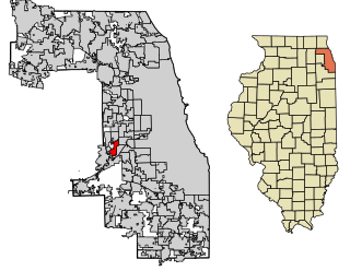
Countryside is a city in Cook County, Illinois, United States. Per the 2020 census, the population was 6,420.

<span class="mw-page-title-main">Woodridge, Illinois</span> Village in Illinois, United States

Woodridge is a village in DuPage County, Illinois, with small portions in Will and Cook counties, and a southwestern suburb of Chicago. Per the 2020 census, the population was 34,158.

<span class="mw-page-title-main">Bolingbrook, Illinois</span> Village in Illinois, United States

Bolingbrook is a village in Will and DuPage counties in the U.S. state of Illinois. It is a southwest suburb of Chicago on I-55 and Historic Route 66. The village was a new town built on the Gateway Wetlands west of the Des Plaines River in the 1960s. Bolingbrook experienced rapid growth in the 1980s and 1990s, eventually becoming Will county's second largest town after Joliet. Per the 2020 census, the population was 73,922. As of 2010, it is the 17th largest incorporated place in Illinois and the state's second-largest village.

<span class="mw-page-title-main">Antioch, Illinois</span> Village in Illinois, United States

Antioch is a village in the U.S. state of Illinois. Antioch is part of the larger Antioch Township within Lake County. As of the 2020 census, the population was 14,622. The village is nestled into the Chain O'Lakes waterway system and borders the state of Wisconsin. Part of the Chicago metropolitan area, Antioch is located approximately halfway between the major cities of Chicago and Milwaukee.

<span class="mw-page-title-main">Beach Park, Illinois</span> Village in Illinois, United States

Beach Park is a village in Benton and Waukegan townships of Lake County, Illinois, United States. Per the 2020 census, the population was 14,249.

Gages Lake is a census-designated place (CDP) in Warren Township, Lake County, Illinois, United States. The population was 10,637 at the 2020 census.

<span class="mw-page-title-main">Grayslake, Illinois</span> Village in Illinois, United States

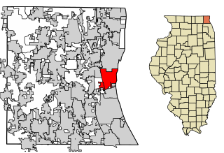
Grayslake is a village in Lake County, Illinois, United States. It is located in the Chicago metropolitan area, about 40 miles (64 km) north of Chicago's downtown, 14 miles (23 km) west of Lake Michigan, and 15 miles (24 km) south of the Wisconsin border. The village's population at the 2020 census was 21,248.

<span class="mw-page-title-main">Gurnee, Illinois</span> Village in Illinois, United States

Gurnee is a village and suburb in Lake County, Illinois, United States. Its population was 30,706 as of the 2020 census. It borders the city of Waukegan, and is a popular tourist attraction within the Chicago metropolitan area.

<span class="mw-page-title-main">Lake Bluff, Illinois</span> Village in Illinois, United States

Lake Bluff is a village in Lake County, Illinois, United States. Per the 2020 census, the population was 5,616.

<span class="mw-page-title-main">Lake Forest, Illinois</span> City in Illinois, United States

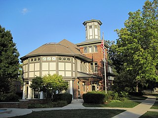
Lake Forest is a city located in Lake County, Illinois, United States. Per the 2020 census, the population was 19,367. The city is along the shore of Lake Michigan, and is a part of the Chicago metropolitan area and the North Shore. Lake Forest was founded with Lake Forest College and was laid out as a town in 1857, a stop for travelers making their way south to Chicago. The Lake Forest City Hall, designed by Charles Sumner Frost, was completed in 1898. It originally housed the fire department, the Lake Forest Library, and city offices.

<span class="mw-page-title-main">Libertyville, Illinois</span> Village in Illinois, United States

Libertyville is a village in Lake County, Illinois, United States, and a northern suburb of Chicago. It is located 5 miles (8 km) west of Lake Michigan along the Des Plaines River. The 2020 census population was 20,579. It is part of Libertyville Township, which includes the village, neighboring Green Oaks, and portions of Vernon Hills, Mundelein, unincorporated Waukegan and Lake Forest, and part of Knollwood CDP. Libertyville neighbors these communities as well as Gurnee to the north and Grayslake to the northwest. Libertyville is about 40 miles north of the Chicago Loop and is part of the United States Census Bureau's Chicago combined statistical area (CSA).

<span class="mw-page-title-main">Mettawa, Illinois</span> Village in Illinois, United States

Mettawa is a village in Lake County, Illinois, United States. Per the 2020 census, the population was 533. The village maintains trails for pedestrian, bicycle and equestrian usage. Five forest preserves of the Lake County Forest Preserve District are located within village boundaries.

<span class="mw-page-title-main">North Chicago, Illinois</span> City in Illinois, United States

North Chicago is a city in Lake County, Illinois, United States, and a suburb of the Chicago metropolitan area. The population was 30,759 at the 2020 census making it the 3rd largest city by population in the county, after Waukegan and Mundelein.

<span class="mw-page-title-main">Vernon Hills, Illinois</span> Village in Illinois, United States

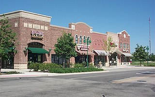
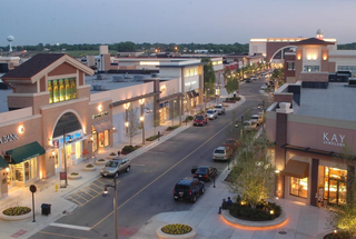
Vernon Hills is a suburb north of Chicago, Illinois in Lake County, Illinois, United States. The population was 26,850 at the 2020 census. Vernon Hills serves as a retail hub for its surrounding area.

<span class="mw-page-title-main">Waukegan, Illinois</span> City in Illinois, United States

Waukegan is the most populous city in and the county seat of Lake County, Illinois, United States. An industrial suburb of Chicago, Waukegan is situated about 26 miles (42 km) north of Chicago’s city limits. As of the 2020 census, its population was 89,321, ranking it the seventh-most populous city within the Chicago metropolitan area and the 10th-most populous city in Illinois.

<span class="mw-page-title-main">North Shore (Chicago)</span> Many affluent suburbs north of Chicago, Illinois

The North Shore consists of many affluent suburbs north of Chicago, Illinois, bordering the shores of Lake Michigan. These communities fall within suburban Cook Countyand Lake County. The North Shore's membership is often a topic of debate, and it includes some Chicago suburbs which do not border Lake Michigan. However, Deerfield, Evanston, Wilmette, Kenilworth, Winnetka, Glencoe, Glenview, Highland Park, Highwood, Lake Forest, Northbrook, Northfield and Lake Bluff are generally considered to be the main constituents of the North Shore.

<span class="mw-page-title-main">Rondout, Illinois</span> Unincorporated community in Illinois, United States

Rondout is an unincorporated community in Lake County, Illinois, United States that first formed around a railroad junction. The area is located within Libertyville Township. As Rondout is an unincorporated community rather than a municipality, it lacks clearly defined borders, and shares postal codes with Lake Bluff, Lake Forest and Libertyville, Illinois. It has its own elementary school which comes under Rondout School District 72. Illinois Route 176 passes east–west through Rondout, serving as the "main street" of the community, where it is also called "Rockland Road".

<span class="mw-page-title-main">Libertyville Township, Lake County, Illinois</span> Township in Illinois, United States

Libertyville Township is a township in Lake County, Illinois, United States. As of the 2010 census, its population was 53,139. The village of Libertyville is part of the township, as are parts of Green Oaks, Lake Bluff, Lake Forest, Mettawa, Mundelein, North Chicago, Rondout, Vernon Hills and Waukegan.

<span class="mw-page-title-main">Shields Township, Lake County, Illinois</span> Township in Illinois, United States

Shields Township is a township in Lake County, Illinois, USA. As of the 2010 census, its population was 39,062. The Naval Station Great Lakes is located in this township.

References

  1. "2020 U.S. Gazetteer Files". United States Census Bureau. Retrieved March 15, 2022.
  2. "Knollwood CDP, Illinois". United States Census Bureau . Retrieved April 15, 2022.
  3. "Lake Forest, Libertyville take over providing services to Rockland Fire Protection District". Chicago Tribune. October 22, 2018. Retrieved December 11, 2019.
  4. 1 2 Teter, Lucius. "Club History". Knollwood Club. Archived from the original on August 23, 2012. Retrieved December 22, 2012.
  5. http://www.cityoflakeforest.com/pdf/rec/Forestry/Witness%20Tree%20Booklet%20Final.pdf%5B%5D
  6. "Knollwood Facts". Knollwood Neighbors. Retrieved December 22, 2012.
  7. "Knollwood Facts". Knollwood Neighbors. Retrieved December 22, 2012. The Knollwood Club now lies within the boundaries of Lake Forest.
  8. "Founding". Knollwood Fire Department. Retrieved December 23, 2012.
  9. "Our Station". Knollwood Fire Department. Retrieved December 23, 2012.
  10. "North Shore fire department considers disbanding to cut costs" . Retrieved December 11, 2019.
  11. "Opinion: Politics At Play in Rockland Fire District" . Retrieved December 11, 2019.
  12. "Rockland Fire Protection District - Minutes of Special Meeting" (PDF). Retrieved December 11, 2019.
  13. David Ibata (October 5, 1988). "High Court Shuns Knollwood's Appeal". Chicago Tribune. Retrieved December 22, 2012. Felknor referred to a 1982 referendum in which Lake Bluff residents voted down a Knollwood annexation by three votes out of 1,600 cast.
  14. Stephania H. Davis (November 26, 1996). "Annexation Battle Leaves Scars In, Near Lake Bluff". Chicago Tribune. Retrieved December 22, 2012. But Nov. 5, Lake Bluff residents voted overwhelmingly against the annexation in an advisory referendum, defeating the measure 2,099 to 903.
  15. "U.S. Gazetteer Files: 2019: Places: Illinois". U.S. Census Bureau Geography Division. Retrieved December 24, 2019.
  16. "Decennial Census of Population and Housing by Decades". US Census Bureau.
  17. 1 2 "P2 HISPANIC OR LATINO, AND NOT HISPANIC OR LATINO BY RACE – 2010: DEC Redistricting Data (PL 94-171) – Knollwood CDP, Illinois". United States Census Bureau .
  18. 1 2 "P2 HISPANIC OR LATINO, AND NOT HISPANIC OR LATINO BY RACE – 2020: DEC Redistricting Data (PL 94-171) – Knollwood CDP, Illinois". United States Census Bureau .
  19. Hedien, Laura. "Stations and Stops". Archived from the original on December 3, 2012. Retrieved December 23, 2012.
  20. Jaenicke, Paul W.; Ralph A. Eisenbrandt (2007). Elgin, Joliet and Eastern Railway. Arcadia Publishing. p. 7.
  21. "The Village of Lake Bluff - the Village of Lake Bluff" (PDF).