Vidora

Last updated

Vidora
Main Street Vidora, Saskatchewan.JPG
Main Street Vidora 2010
Motto: 
"The Place to Be" (1910s)
CAN SK Reno map 2021.png
Red pog.svg
Vidora
Canada Saskatchewan location map.svg
Red pog.svg
Vidora
Coordinates: 49°19′38″N109°24′30″W / 49.3272°N 109.4084°W / 49.3272; -109.4084
Country Canada
Province Saskatchewan
Region Southwest
Rural municipality Reno No. 51
Established1910
Incorporated (Village)1917
Restructured (Unincorporated)January 1, 1952
Government
   Reeve Brian McMillan
  AdministratorLacelle Kim
  Governing body Reno No. 51
   MLA Doug Steele
   MP Jeremy Patzer
Population
 (1920)
  Total200
Postal code
S0N 2W0
Area code 306
Highways Highway 13
Railways Great Western Railway
[1] [2] [3] [4]

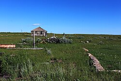
Vidora is an unincorporated community within the Rural Municipality of Reno No. 51, Saskatchewan, Canada. The community once had a population of 200 people in 1940 and has since declined to 1 resident. It previously held village status until it was dissolved as an unincorporated community on January 1, 1952. The community is located between Robsart and Consul on highway 21 & highway 13 known as the Red Coat Trail. Very little remains of the former village, only one home that is also used as a post office still stands as of 2008. There are many cement foundations and sidewalks still found scattered around the town site, including the remnants of the old bank vault to the former Municipality Office that was moved to Consul.

Contents

History

C.P.R. station Vidora train station.jpg
C.P.R. station

In 1910 construction of the Canadian Pacific Railway line came through Vidora. Many of the CPR's engineers and surveyors were housed at a local farm house during construction of the rail line. Living at the same house where two girls named "Vivian" and "Dorothy", the engineers and surveyors decided to use their names to name the new area, because of their great hospitality, thus giving the town its name "Vidora". After the land was named, settlers as well as bootleggers began to settle the area starting the community of Vidora. By 1917, the community was incorporated as a village, and now had its very own town Council, and mayor. After becoming a village, Vidora began to grow quite fast and prosperous. By 1920, the village business districts consist of more than twenty businesses, including businesses such as a post office, cafe, pool hall, main hall, banks, lumber yards, general stores, a hotel and a spectacular row of 5 grain elevators. Vidora even had its very own electrical power plant, powering the whole town.

Prior to January 1, 1952, Vidora was incorporated as a village, and was restructured as an unincorporated community under the jurisdiction of the Rural municipality of Reno on that date. [5]

Prohibition

Like most towns throughout Alberta and Saskatchewan, Vidora began as a small parcel of land owned by the Canadian Pacific Railway. Like many towns of southwest Alberta and Saskatchewan such as Govenlock, Senate and Whiskey Gap, Alberta Vidora had a fair amount of bootleggers, that came into the area to smuggle rum, alcohol, and whisky across the border during Prohibition in the United States.

The Great Depression

Fire of 1924 wiping out many crucial businesses. Vidora1924.jpg
Fire of 1924 wiping out many crucial businesses.

Vidora's future looked promising but due to the Great Depression years, with accompanying droughts, falling grain prices and poor crop yields, Vidora's population slowly began to decline. Beginning in 1924 a devastating fire destroyed many important businesses including Vidora's first store, post office, cafe, pool hall and main hall. Then in 1926 and 1928 more vital businesses would also be wiped out by fire. In 1936 the CPR station closed and afterwards moved to Frontier. In 1961 the Vidora General Store was moved to Robsart, then in 1969 the rural municipal office was also moved to Consul as did the Vidora Community Hall in 1976. To mark the end of its long prosperous life, Vidora's five grain elevators closed and were torn down sometime in the 1970s or 1980s.

Notable people

See also

Related Research Articles

Rockglen is a town in the Burning Hills of the Wood Mountain Uplands, in Saskatchewan, Canada. It offers various amenities including a school, community hall, public library and five parks, as well a local service industry. The municipal office of the Rural Municipality of Poplar Valley No. 12 lies within the boundaries of Rockglen, and Rockglen businesses are supported primarily by agriculture. In the Burning Hills agriculture consists of dry land farming and cattle. Rockglen is located along Highway 2 south of Assiniboia, Highway 18 west of Coronach, and Highways 2 and 18 north of Port Poplar River. Fife Lake is 9.3 kilometres (5.8 mi) to the east.

<span class="mw-page-title-main">Division No. 4, Saskatchewan</span> Census division of Saskatchewan, Canada

Division No. 4 is one of eighteen census divisions in the province of Saskatchewan, Canada, as defined by Statistics Canada. It is located in the southwest corner of the province, bordering Alberta to the west and Montana, United States to the south. The most populous community in this division is Maple Creek.

Arbuthnot is an unincorporated community located in Glen Bain Rural Municipality No. 105, Saskatchewan, Canada east of Route 19. It was located in census Division No. 2. It was on mile 63 of the Canadian Pacific Railway right of way, southeast of Swift Current and in the NW section 9- township 10- range 7 west of the third meridian.

Cheadle is a hamlet in Alberta, Canada within Wheatland County. It is located on Highway 24, 2 kilometers (1.2 mi) south of the Highway 1 and approximately 35 kilometers (22 mi) east of the City of Calgary.

Love is a village in the Canadian province of Saskatchewan within the Rural Municipality of Torch River No. 488 and Census Division No. 14. The village is northeast of the City of Prince Albert and about 48 km (30 mi) south of Prince Albert National Park boundaries and 16 km (9.9 mi) south of Torch River Provincial Forest.

<span class="mw-page-title-main">Robsart, Saskatchewan</span> Unincorporated hamlet in Saskatchewan, Canada

Robsart is an unincorporated hamlet within the rural municipality of Reno No. 51, in the province of Saskatchewan, Canada. Robsart had a population of 20 at the 2016 Canada Census. Robsart previously incorporated an independent village since 1912 until it was dissolved into an unincorporated community on January 1, 2002 under the jurisdiction of the rural municipality of Reno No. 51. Robsart is located 48 km southwest of the town of Eastend at the junction of Highway 18 and Highway 13 approximately 170 km south-east of Medicine Hat, Alberta, 68 km south of the Town of Maple Creek.

Govenlock is an unincorporated community within the Rural Municipality of Reno No. 51, Saskatchewan, Canada. It previously held the status of a village, with a peak population of 151 residents; its village status was dissolved on January 1, 1976. The former townsite of Govenlock is located on Highway 21 & Highway 13, also known as the historic Red Coat Trail, about 15 km east of the Alberta-Saskatchewan border. Although many cement foundations and wooden sidewalks can still be found scattered around the town site, the only building that still stands as of 2010 is the old community hall and a commemorative plaque in remembrance of Govenlock's rich history.

Estuary is a hamlet in RM of Deer Forks No. 232 in the Canadian province of Saskatchewan. Very little remains of the former village of 800, other than a private residence and a pioneer cemetery on a small hill known as Cemetery Hill, overlooking the South Saskatchewan River.

Expanse, Saskatchewan is an unincorporated area in the rural municipality of Lake Johnston No. 102, in the Canadian province of Saskatchewan. Expanse is located just south of Old Wives Lake on a grid road. The grid connects to Highway 2 near Ardill in south central Saskatchewan. Just to the south of Highway 2 is Lake of the Rivers. Expanse is too small to be enumerated as a separate entity during the census taking, so it was a part of the population given for rural municipality of Lake Johnston No. 102.

<span class="mw-page-title-main">Retlaw, Alberta</span> Unincorporated community in Alberta, Canada

Retlaw is an unincorporated community located in the Municipal District of Taber, Alberta, Canada. The community once had a peak population of over 250 citizens and was even incorporated under the status of a village until it was dissolved into a hamlet under the jurisdiction of Improvement District No. 96 on March 1, 1939. Retlaw is located 2 km (1 mi) west of Highway 864 6 km (3 mi) west of Vauxhall and 42 km (26 mi) northwest of Taber and 75 km (46 mi) southwest of Brooks.

<span class="mw-page-title-main">Rural Municipality of Reno No. 51</span> Rural municipality in Saskatchewan, Canada

The Rural Municipality of Reno No. 51 is a rural municipality (RM) in the Canadian province of Saskatchewan within Census Division No. 4 and SARM Division No. 3. Located in the southwest corner of the province, it is adjacent to the United States border to the south and the Alberta boundary to the west.

Senate is an unincorporated community within the Rural Municipality of Reno No. 51, Saskatchewan, Canada. The village had a population of 63 around 1940 and has since declined to 0 residents. The townsite is located along Hwy 21 & the historic Red Coat Trail, about 20 km east of the Alberta-Saskatchewan border and is about 200 km southwest of the city of Swift Current.

Loomis, also known as Echo, is an unincorporated community in Frontier Rural Municipality No. 19, Saskatchewan, Canada. The community is located on the intersection of Highway 18 and Highway 614, about 70 km southeast of the community of Robsart and about 38 km south of the town of Eastend.

Rangeview is an unincorporated community within the Rural Municipality of Reno No. 51, Saskatchewan, Canada. The former town-site is located 5 km west of Highway 18, about 15 km south of the community of Robsart and Highway 13.

Oxarat is an unincorporated community within Rural Municipality of Reno No. 51, Saskatchewan, Canada. The former town-site is located 15 km west of Highway 21, about 15 kilometres (9.3 mi) north of the village of Consul and Highway 13.

<span class="mw-page-title-main">Ardath, Saskatchewan</span> Unincorporated community in Saskatchewan, Canada

Ardath is an unincorporated community in the west-central region of Saskatchewan located on Highway 654, along the Canadian National Railway, Delisle-Tichfield Junction stub. The community is located approximately 10 kilometres (6.2 mi) north of Conquest and is about 20 km (12 mi) north west of Outlook. Its most notable buildings are a curling rink and a brick United Church.

<span class="mw-page-title-main">Bents</span> Unincorporated community in Saskatchewan, Canada

Bents is an unincorporated community in Marriott No. 317, Saskatchewan, Canada. Prior to the town founding, the area was referred to as Piche. Bents took its name from Longniddry Bents in Scotland. Its derelict wooden grain elevator was once the subject of a National Geographic photograph. The remnants of the town are now located on private property.

<span class="mw-page-title-main">Instow, Saskatchewan</span> Unincorporated community in Saskatchewan, Canada

Instow is an unincorporated community within the Rural Municipality of Bone Creek No. 108, Saskatchewan, Canada. The community is located on Highway 13 also known as the historic Red Coat Trail, about 10 km northeast of the town of Shaunavon.

Ruthilda is a former village in the Rural Municipality of Grandview No. 349, Saskatchewan, Canada. It dissolved from village status to become part of the Rural Municipality of Grandview No. 349 on December 31, 2013. Ruthilda is located about 5 km south of Highway 51 approximately 30 km southwest of the Town of Biggar.

<span class="mw-page-title-main">Horizon, Saskatchewan</span> Unincorporated Community in Saskatchewan, Canada

Horizon, located on the south side of Channel Lake, is a hamlet in Bengough Rural Municipality No. 40, Saskatchewan, Canada. It previously held the status of village until December 31, 1973. The hamlet is located 60 km (37 mi) east of the Town of Assiniboia on highway 13.

References

  1. National Archives, Archivia Net, Post Offices and Postmasters, archived from the original on 6 October 2006, retrieved 18 January 2008
  2. Government of Saskatchewan, MRD Home, Municipal Directory System, archived from the original on 21 November 2008
  3. Canadian Textiles Institute. (2005), CTI Determine your provincial constituency, archived from the original on 11 September 2007
  4. Commissioner of Canada Elections, Chief Electoral Officer of Canada (2005), Elections Canada On-line
  5. "Restructured Villages". Saskatchewan Ministry of Municipal Affairs. Archived from the original on 25 March 2008. Retrieved 10 February 2008.

49°19′38″N109°24′30″W / 49.3272°N 109.4084°W / 49.3272; -109.4084