
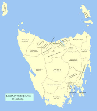
Tasman Council is a local government body in Tasmania, situated in the south-east of the state. Tasman is classified as a rural local government area and has a population of 2,404, the region covers both the Tasman and Forestier peninsulas, with Nubeena the principal town.

Huon Valley Council is a local government body in Tasmania, covering most of the south of the state. Huon Valley is classified as a rural local government area and has a population of 17,219, towns and localities of the region include Cygnet, Dover, Franklin, Geeveston, Southport and the largest principal town, Huonville.

Glamorgan-Spring Bay Council is a local government body in Tasmania, situated on the central east coast of the state. Glamorgan-Spring Bay is classified as a rural local government area and has a population of 4,528, the major towns of the region include Bicheno, Orford and Triabunna with Swansea the principal town.

Break O'Day Council is a local government body in Tasmania, situated in the northern part of the state's east coast. Break O'Day is classified as a rural local government area and has a population of 6,770, the major towns of the region include St Helens, St Marys and Scamander.
Dorset Council is a local government body in Tasmania, located in the far north-east of the state mainland. Dorset is classified as a rural local government area and has a population of 6,652. The major towns and localities of the region include Bridport, Derby and Ringarooma with Scottsdale the regional centre. Dorset was placed under a board of inquiry on 2 August 2023 and is currently under the supervision of commissioner Wardlaw. The current general manager is John Marik.

Meander Valley Council is a local government body in northern Tasmania. It covers the western outskirts of Launceston, and further westward along the Meander River. Meander Valley Council is classified as a rural local government area and has a population of 19,713. Major towns and localities of the region include Elizabeth Town, Mole Creek, Westbury and the principal town of Deloraine.

Central Coast Council is a local government body in Tasmania, situated in the north-west of the state between Burnie and Devonport. Central Coast is classified as an urban local government area and has a population of 22,760, Ulverstone and Penguin are the two primary towns of the region.

Kentish Council is a local government body in Tasmania, situated in the north-west of the state, to the south and inland from Devonport. Kentish is classified as a rural local government area and has a population of 6,324, the major towns of the municipality are Sheffield, Railton and Wilmot.

Circular Head Council is a local government body in Tasmania covering the far north-west mainland. It is classified as a rural local government area with a population of 8,066, and its major towns and localities include Arthur River, Marrawah and Stanley, with Smithton being the largest and principal town. The origin of the name “Circular Head” is unknown.

West Coast Council is a local government body in Tasmania, covering much of the western region of the state. West Coast is classified as a rural local government area and has a population of 4,167. The major towns and localities of the region include Strahan, Rosebery, Zeehan and the principal town of Queenstown.

Central Highlands Council is a local government body in Tasmania, encompassing the Central Highlands region of the state. Central Highlands is classified as a rural local government area and has a population of 2,144, the two largest towns are Bothwell and Hamilton.

Northern Midlands Council is a local government body in Tasmania, extending south of Launceston into the northern region of the Tasmanian central midlands. Northern Midlands is classified as a rural local government area and has a population of 13,300, the major population centres and localities of the region include Campbell Town, Evandale, Longford, and Perth.

Southern Midlands is a local government body in Tasmania, covering the southern region of the Tasmanian central midlands. Southern Midlands is classified as a rural local government area and has a population of 6,118, the major localities of the region include Campania, Kempton, Mangalore and the principal town of Oatlands.

Wynyard (/ˈwɪnjɚd/) wi-nyuhd) is a rural town located on the North West coast of Tasmania, Australia. Wynyard is situated 17 kilometres (11 mi) west of Burnie. As of the 2021 census, Wynyard has an estimated population of 6,296 The town is a regional hub servicing the surrounding rural areas, the adjacent Burnie Wynyard Airport provides commercial flights to Melbourne and other districts. The main council offices for the Waratah-Wynyard local government area are located in Wynyard.
George Town Council is a local government body in northern Tasmania, situated north of Launceston. The George Town local government area is classified as rural and has a population of 6,931, it encompasses the principal town, George Town, and the nearby localities including Hillwood, Low Head and Pipers River.

Burnie City Council is a local government body in Tasmania, located in the city and surrounds of Burnie in the north-west of the state. The Burnie local government area is classified as urban and has a population of 19,348, which also encompasses Cooee, Hampshire, Natone and Ridgley.

Flinders Council is a local government body in Tasmania, encompassing the Furneaux Group and nearby islands of Bass Strait, in the north-east of the state. Flinders is classified as a rural local government area and has a population of 987, with Whitemark the main town located on Flinders Island.
Former Local government areas (LGAs) in the Australian state of Tasmania are amalgamated or cancelled areas.
Rocky Cape is a locality and small rural community in the local government areas of Circular Head and Waratah-Wynyard, in the North-west and west region of Tasmania. It is located about 30 kilometres (19 mi) north-west of the town of Wynyard. The Bass Highway passes through from south-east to north-west. The Rocky Cape National Park is in the north-east of the locality. The 2016 census determined a population of 206 for the state suburb of Rocky Cape.
Myalla is a locality and small rural community in the local government area of Waratah-Wynyard, in the North West region of Tasmania. It is located about 19 kilometres (12 mi) west of the town of Wynyard. The 2016 census determined a population of 54 for the state suburb of Myalla.

