Westmoreland, New York

Last updated

Westmoreland
NY 233 sb, Westmoreland, July 2023.jpg
Southbound NY 233 in Westmoreland
Oneida County New York incorporated and unincorporated areas Westmoreland (town) highlighted.svg
Location in Oneida County and the state of New York
New York in United States (US48).svg
Location of New York in the United States
CountryUnited States
State New York
County Oneida
Government
   Town Supervisor Kenneth Eisnor
  • Hubert Pritchard (R)
  • David Husted (R)
  • Kenneth Eisnor (R)
  • Charles Hebbard (R)
Area
[1]
  Total43.15 sq mi (111.76 km2)
  Land43.14 sq mi (111.72 km2)
  Water0.01 sq mi (0.04 km2)
Population
 (2010)
  Total6,138
  Estimate 
(2016) [2]
6,086
  Density141.09/sq mi (54.48/km2)
Time zone EST
  Summer (DST) EDT
FIPS code 36-065-80533
Website Town website

Westmoreland is a town in Oneida County, New York, United States. The population was 6,138 at the 2010 census.

Contents

The Town of Westmoreland is in the west-central part of the county. The New York State Thruway (Interstate 90) passes across the town. Westmoreland is west of Utica.

History

The town of Westmoreland was first settled in 1748, by James Dean, a missionary among the members of the Oneida tribe. The Town of Westmoreland was formed in 1792 from the Town of Whitestown. In 1802, part of Westmoreland was used to establish the Towns of Vernon and Verona. More of Westmoreland was lost in 1855 on the formation of the Town of Kirkland to the south.

Geography

According to the United States Census Bureau, the town has a total area of 43.2 square miles (112 km2), of which 43.1 square miles (112 km2) is land and 0.04 square miles (0.10 km2) (0.05%) is water.

Demographics

Historical population
CensusPop.Note
1800 1,542
1810 1,135−26.4%
1820 2,791145.9%
1830 3,30318.3%
1840 3,105−6.0%
1850 3,2926.0%
1860 3,166−3.8%
1870 2,952−6.8%
1880 2,744−7.0%
1890 2,313−15.7%
1900 2,192−5.2%
1910 1,995−9.0%
1920 1,984−0.6%
1930 2,1709.4%
1940 2,2353.0%
1950 2,81125.8%
1960 4,08445.3%
1970 5,09324.7%
1980 5,4587.2%
1990 5,7375.1%
2000 6,2138.3%
2010 6,138−1.2%
2016 (est.)6,086 [2] −0.8%
U.S. Decennial Census [3]

As of the census [4] of 2000, there were 6,207 people, 2,234 households, and 1,717 families residing in the town. The population density was 143.9 inhabitants per square mile (55.6/km2). There were 2,323 housing units at an average density of 53.9 per square mile (20.8/km2). The racial makeup of the town was 98.15% White, 0.69% African American, 0.24% Native American, 0.29% Asian, 0.21% from other races, and 0.42% from two or more races. Hispanic or Latino of any race were 0.95% of the population.

There were 2,234 households, out of which 37.0% had children under the age of 18 living with them, 64.8% were married couples living together, 7.9% had a female householder with no husband present, and 23.1% were non-families. 18.7% of all households were made up of individuals, and 8.1% had someone living alone who was 65 years of age or older. The average household size was 2.75 and the average family size was 3.14.

In the town, the population was spread out, with 27.6% under the age of 18, 6.2% from 18 to 24, 29.4% from 25 to 44, 24.2% from 45 to 64, and 12.6% who were 65 years of age or older. The median age was 38 years. For every 100 females, there were 104.0 males. For every 100 females age 18 and over, there were 98.1 males.

The median income for a household in the town was $48,768, and the median income for a family was $52,257. Males had a median income of $36,024 versus $24,955 for females. The per capita income for the town was $18,452. About 4.0% of families and 5.1% of the population were below the poverty line, including 5.7% of those under age 18 and 3.5% of those age 65 or over.

Communities and locations in the Town of Westmoreland

Education

The Westmoreland Central School District is the only school system in the town. It comprises an elementary school (grades K-2), an upper elementary school (grades 3–6), and a junior-senior high school (grades 7-12). This school district houses an athletics program.

Related Research Articles

<span class="mw-page-title-main">Pembroke, New York</span> Town in New York, United States

Pembroke is a town in Genesee County, Western New York, United States. The population was 4,292 at the 2010 census. The town is named after a town in west Wales. Pembroke lies on the west border of Genesee County, west of Batavia.

<span class="mw-page-title-main">Stafford, New York</span> Town in New York, United States

Stafford is a town in Genesee County, New York, United States. The population was 2,459 at the 2010 census. The town was named after a town of the same name in England.

<span class="mw-page-title-main">Danube, New York</span> Town in New York, United States

Danube is a town in Herkimer County, New York, United States. The population was 801 at the 2020 census, down from 1,039 in 2010. Early Palatine German immigrants in the eighteenth century named the town after the Danube River in Europe.

<span class="mw-page-title-main">Schuyler, New York</span> Town in Herkimer County, New York, US

Schuyler is a town in Herkimer County, New York, United States. The population was 3,420 at the 2010 census. The town is in the western part of Herkimer County and is east of Utica.

Lenox is a town in Madison County, New York, United States. The population was 8,768 as of the 2020 census.

<span class="mw-page-title-main">Sullivan, New York</span> Town in Madison County, New York, US

Sullivan is a town in Madison County, New York, United States. The population was 15,339 at the 2010 census. The town is named after General John Sullivan.

<span class="mw-page-title-main">Glen, New York</span> Town in New York, United States

Glen is a town in Montgomery County, New York, United States. The population was 2,507 at the 2010 census. The town was named after Jacob Glen, an early landowner.

<span class="mw-page-title-main">Deerfield, New York</span> Town in New York, United States

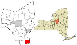
Deerfield is a town in Oneida County, New York, United States. The population was 4,273 at the 2010 census.

<span class="mw-page-title-main">Kirkland, New York</span> Town in Oneida County, New York, United States

Kirkland is a town in Oneida County, New York, United States. The population was 10,075 at the 2020 census. The town is named after Samuel Kirkland, a missionary among the Oneidas.

<span class="mw-page-title-main">Verona, New York</span> Town in New York, United States

Verona is a town in southwestern Oneida County, New York, United States. The population was 6,293 at the 2010 census. The town was named after Verona, Italy.

<span class="mw-page-title-main">Vienna, New York</span> Town in New York, United States

Vienna is a town in Oneida County, New York, United States. The population was 5,440 at the 2010 census. The town is named after the capital of Austria.

<span class="mw-page-title-main">Whitestown, New York</span> Town in New York, United States

Whitestown is a town in Oneida County, New York, United States. The population was 18,667 at the 2010 census. The name is derived from Judge Hugh White, an early settler. The town is immediately west of Utica and the New York State Thruway passes across the town. The offices of the town of Whitestown are in the Village of Whitesboro.

<span class="mw-page-title-main">Cicero, New York</span> Town in New York, United States

Cicero is a town in northern Onondaga County, New York, United States. As of the 2020 Census, the population was 31,435. The name of the town was assigned by a clerk interested in the classics, honoring Cicero, a Roman statesman.

<span class="mw-page-title-main">Hastings, New York</span> Town in New York, United States

Hastings is a town in Oswego County, New York, United States. Its population was 9,450 at the 2010 census. It is named after Hastings Curtiss, a prominent citizen and member of the State Assembly in 1824.

Hamilton is a town in Madison County, New York, United States. The population was 6,379 at the 2020 census. The town is named after American Founding Father Alexander Hamilton, and is a college town, with Colgate University dominating the town's employment, culture and population.

<span class="mw-page-title-main">Bridgewater, New York</span> Town in New York, United States

Bridgewater is a town in Oneida County, New York, United States. The population was 1,522 at the 2010 census.

<span class="mw-page-title-main">Vernon, New York</span> Town in New York, United States

Vernon is a town in Oneida County, New York, United States. The population was 5,408 at the 2010 census.

<span class="mw-page-title-main">Constantia, New York</span> Town in New York, United States

Constantia is a town in Oswego County, New York, United States. The population was 4,973 at the 2010 census. The town is located in the southeastern part of the county. Within the town is a hamlet and census-designated place of the same name.

Candor is a town in Tioga County, New York, United States. The population was 5,172 at the 2020 census.

<span class="mw-page-title-main">Plattekill, New York</span> Place in New York, United States

Plattekill is a town in Ulster County, New York, United States. The population was 10,424 in 2020, a slight decrease from 10,499 at the 2010 census. The name is derived from a stream, the Platte Kill.

References

  1. "2016 U.S. Gazetteer Files". United States Census Bureau. Retrieved July 5, 2017.
  2. 1 2 "Population and Housing Unit Estimates" . Retrieved June 9, 2017.
  3. "Census of Population and Housing". Census.gov. Retrieved June 4, 2015.
  4. "U.S. Census website". United States Census Bureau . Retrieved January 31, 2008.