Yorkville, Oneida County, New York

Last updated

Yorkville
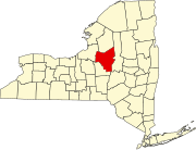
Oneida County New York incorporated and unincorporated areas Yorkville highlighted.svg
Location in Oneida County and the state of New York.
Coordinates: 43°6′39″N75°16′24″W / 43.11083°N 75.27333°W / 43.11083; -75.27333
CountryUnited States
State New York
County Oneida
Government
   Mayor Michael A. Mahoney
Area
[1]
  Total0.67 sq mi (1.74 km2)
  Land0.67 sq mi (1.74 km2)
  Water0.00 sq mi (0.00 km2)
Population
 (2020)
  Total2,657
  Density3,959.76/sq mi (1,528.08/km2)
Time zone UTC-5 (Eastern (EST))
  Summer (DST) UTC-4 (EDT)
ZIP codes
13495
FIPS code 36-84099

Yorkville is a village in Oneida County, New York, United States. The population was 2,689 at the 2010 census.

Contents

The Village of Yorkville is in the southeastern part of the Town of Whitestown adjacent to the City of Utica.

History

The early population was composed of workers from the textile mills in adjacent New York Mills. The village was incorporated in 1902. [2]

Geography

Yorkville is located at 43°6′39″N75°16′24″W / 43.11083°N 75.27333°W / 43.11083; -75.27333 (43.110719, -75.273306). [3]

According to the United States Census Bureau, the village has a total area of 0.7 square mile (1.7 km2), all land.

Demographics

Historical population
CensusPop.Note
1870 213
1880 29538.5%
1910 691
1920 1,512118.8%
1930 3,406125.3%
1940 3,311−2.8%
1950 3,5286.6%
1960 3,7496.3%
1970 3,425−8.6%
1980 3,115−9.1%
1990 2,972−4.6%
2000 2,675−10.0%
2010 2,6890.5%
2020 2,657−1.2%
U.S. Decennial Census [4]

As of the census of 2000, there were 2,675 people, 1,160 households, and 718 families residing in the village. The population density was 4,005.7 inhabitants per square mile (1,546.6/km2). There were 1,259 housing units at an average density of 1,885.3 per square mile (727.9/km2). The racial makeup of the village was 98.24% White, 0.49% African American, 0.49% Asian, 0.22% from other races, and 0.56% from two or more races. Hispanic or Latino of any race were 1.16% of the population.

There were 1,160 households, out of which 27.0% had children under the age of 18 living with them, 42.9% were married couples living together, 14.7% had a female householder with no husband present, and 38.1% were non-families. 33.5% of all households were made up of individuals, and 16.3% had someone living alone who was 65 years of age or older. The average household size was 2.30 and the average family size was 2.91.

In the village, the population was spread out, with 22.5% under the age of 18, 8.7% from 18 to 24, 27.1% from 25 to 44, 22.4% from 45 to 64, and 19.3% who were 65 years of age or older. The median age was 39 years. For every 100 females, there were 88.8 males. For every 100 females age 18 and over, there were 87.0 males.

The median income for a household in the village was $33,490, and the median income for a family was $42,813. Males had a median income of $29,575 versus $22,382 for females. The per capita income for the village was $17,727. 12.1% of the population and 10.1% of families were below the poverty line. Out of the total people living in poverty, 23.7% are under the age of 18 and 8.2% are 65 or older.

Economy

Once supported by manufacturing, the area has lost most of jobs in this field. Hyosung USA operated a 240,000 square foot reinforced fabric lining plant on 2214 Whitesboro Street. Former Utica Converts, Hyosung acquired the plant in 2008 and closed in 2013 laying off 85. Built in 1908, the plant was once a Goodyear plant. [5]

Service, education and health care jobs provide employment at nearby St. Luke's Memorial Hospital and Utica College.

Related Research Articles

<span class="mw-page-title-main">Otsego County, New York</span> County in New York, United States

Otsego County is a county in the U.S. state of New York located within the Mohawk Valley Region. As of the 2020 census, the population was 58,524. The county seat is Cooperstown. The county's population center is Oneonta. The name Otsego is from a Mohawk or Oneida word meaning "place of the rock." The county is part of the Mohawk Valley region of the state.

<span class="mw-page-title-main">Carroll County, Ohio</span> County in Ohio, United States

Carroll County is a county located in the state of Ohio. As of the 2020 census, the population was 26,721. Its county seat is Carrollton, while its largest village is Minerva. It is named for Charles Carroll of Carrollton, the last surviving signer of the Declaration of Independence. Carroll County is part of the Canton-Massillon, OH Metropolitan Statistical Area, which is also included in the Cleveland-Akron-Canton, OH Combined Statistical Area. It is in the Appalachian Ohio region.

<span class="mw-page-title-main">Cold Brook, New York</span> Village in New York, United States

Cold Brook is a village in Herkimer County, New York. The population was 329 at the time of the 2010 census. It is named after a stream passing through the village. The village is located in the south part of the town of Russia and is northeast of Utica.

Clark Mills is a hamlet in Oneida County, New York, United States. The population was 1,905 at the 2010 census.

<span class="mw-page-title-main">New York Mills, New York</span> Village in New York, United States

New York Mills is a village in Oneida County, New York, United States. The population was 3,327 at the 2010 census.

<span class="mw-page-title-main">Prospect, New York</span> Hamlet in New York, United States

Prospect is a hamlet in the town of Trenton, in Oneida County, New York, United States. The population was 291 at the 2010 census. The hamlet is located at the junction of NY 365 and Reference Route 920V west of West Canada Creek. It was an incorporated village from 1890 to 2015.

<span class="mw-page-title-main">Westmoreland, New York</span> Town in New York, United States

Westmoreland is a town in Oneida County, New York, United States. The population was 6,138 at the 2010 census.

<span class="mw-page-title-main">Whitesboro, New York</span> Village in New York, United States

Whitesboro is a village in Oneida County, New York, United States. The population was 3,772 at the 2010 census. The village is named after Hugh White, an early settler.

<span class="mw-page-title-main">Whitestown, New York</span> Town in New York, United States

Whitestown is a town in Oneida County, New York, United States. The population was 18,667 at the 2010 census. The name is derived from Judge Hugh White, an early settler. The town is immediately west of Utica and the New York State Thruway passes across the town. The offices of the town of Whitestown are in the Village of Whitesboro.

<span class="mw-page-title-main">Maple Bluff, Wisconsin</span> Village in Wisconsin, United States

Maple Bluff is a village in Dane County, Wisconsin, United States. The population was 1,313 at the 2010 census. A suburb of Madison, it is part of the Madison Metropolitan Statistical Area.

<span class="mw-page-title-main">Yorkville, Wisconsin</span> Village in Wisconsin, United States

Yorkville is a town in Racine County, Wisconsin, United States. The population was 3,246 at the 2020 census. The unincorporated communities of Ives Grove, Sylvania, and Yorkville are located in the town.

Dolgeville is a village in Herkimer and Fulton counties, New York, United States. The population was 2,206 at the 2010 census. The village is named after the industrialist Alfred Dolge.

<span class="mw-page-title-main">Yorkville, Ohio</span> Village in Ohio, United States

Yorkville is a village in Belmont and Jefferson counties in the U.S. state of Ohio. The population was 968 at the 2020 census. Yorkville lies within two Metropolitan Statistical Areas; the Belmont County portion is part of the Wheeling metropolitan area, while the Jefferson County portion is part of the Weirton–Steubenville metropolitan area.

<span class="mw-page-title-main">Utica, Ohio</span> Village in Ohio, United States

Utica is a village in Knox and Licking counties in the U.S. state of Ohio, along the North Fork of the Licking River. The population was 2,064 at the 2020 census.

Frankfort is a village in the town of Frankfort, Herkimer County, New York, United States. The population was 2,598 at the 2010 census, out of 7,636 people in the entire town. Like the town, the village is named after an early settler, Lawrence (Lewis) Frank.

Turin is a village in Lewis County, New York, United States. The village is within the town of Turin and is north of the city of Rome. As of the 2010 census, the village population was 232.

<span class="mw-page-title-main">New Hartford (village), New York</span> Village in New York, United States

New Hartford is a village in Oneida County, New York, United States. The population was 1,847 at the 2010 census. The name was provided by early settlers from New Hartford, Connecticut.

<span class="mw-page-title-main">Remsen (village), New York</span> Village in New York, United States

Remsen is a village in Oneida County, New York, United States. The population was 431 at the 2020 census.

Edwards is a hamlet in St. Lawrence County, New York, United States. The population was 439 at the 2010 census. It was an incorporated village until dissolution in 2012.

<span class="mw-page-title-main">Linden, Wisconsin</span> Village in Wisconsin, United States

Linden is a village in Iowa County, Wisconsin, United States. The population was 549 at the 2010 census. The village is located within the Town of Linden.

References

  1. "ArcGIS REST Services Directory". United States Census Bureau. Retrieved September 20, 2022.
  2. "New York Mills celebrates it centennial" . Retrieved August 5, 2023.
  3. "US Gazetteer files: 2010, 2000, and 1990". United States Census Bureau. February 12, 2011. Retrieved April 23, 2011.
  4. "Census of Population and Housing". Census.gov. Archived from the original on April 26, 2015. Retrieved June 4, 2015.
  5. "NBC-WKTV News Channel 2 | Utica, NY News, Weather and Sports Mobile Edition - Our Economy in Crisis - Hyosung to close Utica plant, 85 remaining employees to be affected". www.wktv.com. Archived from the original on June 30, 2013. Retrieved February 3, 2022.