Whitesboro, New York

Last updated

Whitesboro, New York
Whitesboro, New York Commercial Buildings.jpg
Commercial buildings on Main Street in Whitesboro
Whitesboro, New York new city seal (adopted in 2017).png
Oneida County New York incorporated and unincorporated areas Whitesboro highlighted.svg
Location in Oneida County and the state of New York.
Coordinates: 43°7′N75°18′W / 43.117°N 75.300°W / 43.117; -75.300
CountryUnited States
State New York
County Oneida
Founded by Hugh White
Area
[1]
  Total1.05 sq mi (2.72 km2)
  Land1.05 sq mi (2.72 km2)
  Water0.00 sq mi (0.00 km2)
Elevation
423 ft (129 m)
Population
 (2020)
  Total3,612
  Density3,440.00/sq mi (1,328.72/km2)
Time zone UTC-5 (Eastern (EST))
  Summer (DST) UTC-4 (EDT)
ZIP code
13492
Area code 315
FIPS code 36-81710 [2]
GNIS feature ID0971160 [3]
Website Official website

Whitesboro is a village in Oneida County, New York, United States. The population was 3,772 at the 2010 census. The village is named after Hugh White, an early settler. [4]

Contents

The Village of Whitesboro is inside the Town of Whitestown.

History

The village began to be settled in 1784, and was incorporated in 1813. An 1851 list gave the name Che-ga-quat-ka for Whitesboro in a language of the Iroquois people. [5]

The abolitionist Oneida Institute (1827–1843) was located in Whitesboro.

Perspective map of Whitesboro from 1891 with list of landmarks Whitesboro, N.Y. LOC 2003630341.tif
Perspective map of Whitesboro from 1891 with list of landmarks

The older part of the village was bordered by the Erie Canal and the village's Main Street. When the canal was filled in the first half of the 20th century, Oriskany Boulevard was built over the filled-in canal. The streets that connect the two roads form the oldest part of the village.[ citation needed ]

The Whitestown Town Hall was listed on the National Register of Historic Places in 1973. [6] It currently serves as the village courthouse, while offices for the Town of Whitestown are housed in newer buildings outside of Whitesboro. [7]

Village seal controversy

The Village's former seal was at the center of controversy Whitesboro New York (city seal).jpeg
The Village's former seal was at the center of controversy

The Whitesboro seal, originating in the early 1900s, displays founder Hugh White wrestling an Oneida Native American. [8] The seal has been controversial because it has been interpreted as a settler choking the Native American; city officials contend it depicts a friendly wrestling match that White won, gaining the respect of the Oneida. [9] The 1970-2017 version of the seal was created after a lawsuit by a Native American group: the version used before the suit showed the settler's hands on the Native American's neck instead of his shoulders. [10] In 1999, Mayor John Malecki suggested a contest for a new seal, but received no submissions. [11]

The seal received attention in 2015 as part of national discussion about display of the Confederate flag. [12] [11] In January 2016, the town cooperated with Comedy Central's The Daily Show to hold a non-binding vote for a new village seal. Many of the alternative seals were humorous, including one depicting the two men as luchadores and another depicting an arm wrestling contest. Village residents voted 157 to 55 to keep the seal as-is. [9] Afterwards, Mayor Patrick O'Connor was criticized for not disclosing Comedy Central's involvement. [13] The Daily Show's January 21 show covered the vote and the controversy around the seal. At the end of the segment, correspondent Jessica Williams announced that the mayor told her that the town would change the seal. [14] This was confirmed by a joint press release from Whitesboro and the Oneida Indian Nation the next day. [15]

An updated seal was adopted in the summer of 2017. [16] The new seal was created by a communication design student at PrattMWP in Utica, under direction of a professor there. [17] While the new seal depicts the same scene as the previous seal, it moves White's hands down to the Oneida chief's upper arms instead of near his neck, and neither man appears to be dominating the other. [18] Additionally, both men were given more realistic skin tones, and their attire was corrected for historical accuracy. [19]

Geography

Whitesboro is located at 43°7′N75°18′W / 43.117°N 75.300°W / 43.117; -75.300 (43.124, -75.296). [20] According to the United States Census Bureau, the village has a total area of 1.1 square miles (2.8 km2), all land. [21]

The Sauquoit Creek forms the boundary with Yorkville. Areas of Whitesboro near the creek suffer from periodic flooding. [22]

Demographics

Historical population
CensusPop.Note
1870 964
1880 1,37042.1%
1890 1,66321.4%
1900 1,95817.7%
1910 2,37521.3%
1920 3,03827.9%
1930 3,37511.1%
1940 3,5324.7%
1950 3,90210.5%
1960 4,78422.6%
1970 4,8050.4%
1980 4,460−7.2%
1990 4,195−5.9%
2000 3,943−6.0%
2010 3,772−4.3%
2020 3,612−4.2%
U.S. Decennial Census [23]

As of the census [2] of 2000, there were 3,943 people, 1,778 households, and 992 families residing in the village. The population density was 3,675.4 inhabitants per square mile (1,419.1/km2). There were 1,921 housing units at an average density of 1,790.6 per square mile (691.4/km2). The racial makeup of the village was 97.69% White, 0.53% African American, 0.03% Native American, 0.33% Asian, 0.53% from other races, and 0.89% from two or more races. Hispanic or Latino of any race were 1.47% of the population.

There were 1,778 households, out of which 27.3% had children under the age of 18 living with them, 36.9% were married couples living together, 15.0% had a female householder with no husband present, and 44.2% were non-families. 39.0% of all households were made up of individuals, and 18.7% had someone living alone who were 65 years of age or older. The average household size was 2.21 and the average family size was 2.98.

In the village, the population was spread out, with 23.3% under the age of 18, 7.8% from 18 to 24, 31.7% from 25 to 44, 20.3% from 45 to 64, and 17.0% who were 65 years of age or older. The median age was 37 years. For every 100 females, there were 86.7 males. For every 100 females age 18 and over, there were 81.2 males.

The median income for a household in the village was $31,947, and the median income for a family was $42,741. Males had a median income of $29,408 versus $25,865 for females. The per capita income for the village was $17,386.

Notable people

Related Research Articles

<span class="mw-page-title-main">Oneida County, New York</span> County in New York, United States

Oneida County is a county in the state of New York, United States. As of February 26, 2024, the population was 226,654. The county seat is Utica. The name is in honor of the Oneida, one of the Five Nations of the Iroquois League or Haudenosaunee, which had long occupied this territory at the time of European encounter and colonization. The federally recognized Oneida Indian Nation has had a reservation in the region since the late 18th century, after the American Revolutionary War.

<span class="mw-page-title-main">Utica, New York</span> City located in central New York, United States

Utica is a city in the Mohawk Valley and the county seat of Oneida County, New York, United States. The tenth-most-populous city in New York State, its population was 65,283 in the 2020 U.S. Census. Located on the Mohawk River at the foot of the Adirondack Mountains, it is approximately 95 mi (153 km) west-northwest of Albany, 55 mi (89 km) east of Syracuse and 240 mi (386 km) northwest of New York City. Utica and the nearby city of Rome anchor the Utica–Rome Metropolitan Statistical Area comprising all of Oneida and Herkimer Counties.

<span class="mw-page-title-main">Barneveld, New York</span> Hamlet and CDP in New York, United States

Barneveld is a hamlet located within the Town of Trenton in Oneida County, New York, United States. The population was 284 at the 2010 census, when it was an incorporated village. The name is derived from the name of the Dutch statesman Johan van Oldenbarnevelt (1547–1619).

<span class="mw-page-title-main">Clinton, Oneida County, New York</span> Village in New York, United States

Clinton is a village in Oneida County, New York, United States. The population was 1,942 at the 2010 census, declining to 1,683 in the 2020 census 13% decline). It was named for George Clinton, the first Governor of New York.

<span class="mw-page-title-main">Marcy, New York</span> Town in New York, United States

Marcy is a town in Oneida County, New York, United States. The population was 8,777 at the 2020 census. The town was named after Governor William L. Marcy. It lies between the cities of Rome and Utica. The Erie Canal passes through the southern part of the town.

<span class="mw-page-title-main">New York Mills, New York</span> Village in New York, United States

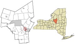
New York Mills is a village in Oneida County, New York, United States. The population was 3,327 at the 2010 census.

<span class="mw-page-title-main">Paris, New York</span> Town in New York, United States

Paris is a town in Oneida County, New York, United States. The town is in the southeast part of the county and is south of Utica. The population was 4,332 at the 2020 census. The town was named after an early benefactor, Colonel Isaac Paris.

<span class="mw-page-title-main">Whitestown, New York</span> Town in New York, United States

Whitestown is a town in Oneida County, New York, United States. The population was 18,667 at the 2010 census. The name is derived from Judge Hugh White, an early settler. The town is immediately west of Utica and the New York State Thruway passes across the town. The offices of the town of Whitestown are in the Village of Whitesboro.

<span class="mw-page-title-main">Yorkville, Oneida County, New York</span> Village in New York, United States

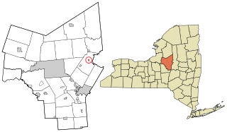
Yorkville is a village in Oneida County, New York, United States. The population was 2,689 at the 2010 census.

<span class="mw-page-title-main">New Hartford, New York</span> Town in New York, United States

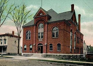
New Hartford is a town in Oneida County, New York, United States. As of the 2020 census, the town population was 21,874. The name of New Hartford was provided by a settler family from Hartford, Connecticut.

<span class="mw-page-title-main">New York State Route 5A</span> State highway in Oneida County, New York, US

New York State Route 5A (NY 5A) is an east–west state highway located within Oneida County, New York, in the United States. It is a 5.59-mile (9.0 km) alternate route of NY 5 between New Hartford and downtown Utica. At its eastern end, NY 5A becomes NY 5S at an interchange with Interstate 790 (I-790), NY 5, NY 8, and NY 12. The route is four lanes wide and passes through mostly commercial areas. When NY 5A was assigned in the mid-1930s, it ended at Yorkville, a village roughly midway between NY 5 in New Hartford and downtown Utica. It was extended to its present length in the 1940s.

<span class="mw-page-title-main">New York State Route 840</span> State highway in Oneida County, New York, US

New York State Route 840 (NY 840) is an east–west state highway located entirely within Oneida County, New York, in the United States. It is a 4.02-mile (6.47 km) superhighway extension of Judd Road, which ends at Halsey Road in Whitestown. The western terminus of NY 840 is at the junction of Judd and Halsey roads while its eastern terminus is at an interchange with the North–South Arterial near the southern city line of Utica. NY 840 opened to traffic in 2005, and the road was ceremoniously designated as the Officer Joseph D. Corr Memorial Highway in 2007. In 2008, part of Judd Road was redesignated as CR 840 to match the designation of its state highway continuation.

<span class="mw-page-title-main">New York State Route 291</span> State highway in Oneida County, New York, US

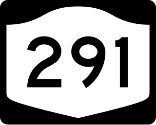
New York State Route 291 (NY 291) is a state highway in Oneida County, New York, in the United States. The route extends from an intersection with NY 69 in the town of Whitestown to a junction with NY 365 in the extreme northern tip of the town of Marcy, near the hamlet of Stittville. It is a two-lane highway its entire length. NY 291 meets NY 49, the Utica–Rome Expressway, at an interchange roughly 1 mile (1.6 km) northeast of NY 69. NY 291 provides access to the Marcy Correctional Facility and Mid-State Correctional Facility, both in Marcy.

<span class="mw-page-title-main">Utica–Rome metropolitan area</span> Metropolitan Statistical Area in New York, United States

The Utica–Rome Metropolitan Statistical Area, as defined by the United States Census Bureau, is an area consisting of two counties in Central New York anchored by the cities of Utica and Rome. As of the 2020 census, the MSA had a population of 292,264.

<span class="mw-page-title-main">Oneida Institute</span> School in upstate New York (1827–1843)

The Oneida Institute was a short-lived (1827–1843) but highly influential school that was a national leader in the emerging abolitionist movement. It was the most radical school in the country, the first at which black men were just as welcome as whites. "Oneida was the seed of Lane Seminary, Western Reserve College, Oberlin and Knox colleges."

This article on the demographics of Utica contains information on population characteristics of Utica, New York, including households, family status, age, gender, income, race and ethnicity.

Sauquoit Creek is a 17.0-mile-long (27.4 km) river in New York, United States. It lies within the southern part of Oneida County. The creek flows eastward, then turns sharply and flows generally northward through the Sauquoit Valley to the Mohawk River, entering the river on the east side of Whitesboro. It is therefore part of the Hudson River watershed.

<span class="mw-page-title-main">Jedediah Sanger</span> American landowner and politician (1751–1829)

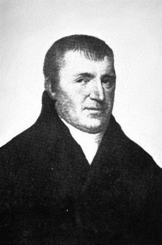
Jedediah Sanger was the founder of the town of New Hartford, New York, United States. He was a native of Sherborn, Massachusetts, and the ninth child of Richard and Deborah Sanger, a prominent colonial New England family. During the Revolutionary War he attained the rank of 1st Lieutenant having fought in the Battles of Lexington and Concord, the Battle of Bunker Hill, the Siege of Boston (1776), and during the New York Campaign.

Marianne Buttenschon is an American politician and educator from the state of New York. She is a member of the New York State Assembly, representing the 119th district.

Harry Sherburn Patten was an American lawyer and politician from New York.

References

  1. "ArcGIS REST Services Directory". United States Census Bureau. Retrieved September 20, 2022.
  2. 1 2 "U.S. Census website". United States Census Bureau. Archived from the original on December 27, 1996. Retrieved January 31, 2008.
  3. "US Board on Geographic Names". United States Geological Survey. October 25, 2007. Archived from the original on February 12, 2012. Retrieved January 31, 2008.
  4. Transactions of the Oneida Historical Society at Utica, 1881–1884 Archived May 16, 2016, at the Wayback Machine , p.73 et seq. (1885)
  5. Jones, Pomroy (1851). Annals and recollections of Oneida County. Rome, New York: Published by the author. p. 872.
  6. "National Register Information System". National Register of Historic Places . National Park Service. March 13, 2009.
  7. "Whitesboro Village Courts". Village of Whitesboro. Retrieved September 19, 2022.
  8. Katz, Brigit. "New York Village Changes Controversial Seal Showing a White Settler Wrestling a Native American". Smithsonian.com. Smithsonian Magazine. Archived from the original on October 5, 2017. Retrieved September 29, 2017.
  9. 1 2 Santora, Marc (January 12, 2016). "Residents in Whitesboro, N.Y., vote to keep a much-criticized village emblem". The New York Times . Archived from the original on September 29, 2017. Retrieved March 3, 2017.
  10. Potts, Courtney (January 4, 2009). "Whitesboro seal 'takes a little explaining'". Observer-Dispatch . Retrieved April 16, 2022.
  11. 1 2 "Whitesboro seal caught up in rebel-flag debate". Observer-Dispatch . July 17, 2015. Retrieved April 16, 2022.
  12. Connor, Jackson (July 7, 2015). "Mayor of Whitesboro, N.Y., Insists This Village Seal Is Not Racist". The Village Voice . Archived from the original on September 11, 2021. Retrieved April 16, 2022.
  13. Cleaver, Jolene (January 13, 2016). "Whitesboro mayor: Disclosing TV presence 'would have tainted the seriousness' of seal vote". Observer-Dispatch . Retrieved April 16, 2022.
  14. "Wrestling with History in Whitesboro, NY". The Daily Show . January 21, 2016. Archived from the original on May 1, 2017. Retrieved March 3, 2017.
  15. "Whitesboro, Oneidas to work together on new seal". Observer-Dispatch . January 22, 2016. Retrieved April 16, 2022.
  16. Krull, Melissa (September 25, 2017). "Whitesboro officially replaces controversial seal". Spectrum News 1 Central New York . Archived from the original on April 16, 2022. Retrieved April 16, 2022.
  17. Koren, Cindiana (September 27, 2017). "Solving Racism – Whitesboro – UPDATE – meetinghouse.co". www.meetinghouse.co. Archived from the original on October 1, 2017. Retrieved September 30, 2017.
  18. Maya Salam (September 27, 2017). "New York Village's Seal, Widely Criticized as Racist, Has Been Changed". The New York Times. Archived from the original on September 28, 2017. Retrieved September 29, 2017.
  19. Cleaver, Jolene (September 26, 2017). "After past uproar, Whitesboro has new village seal". Observer-Dispatch . Retrieved April 16, 2022.
  20. "US Gazetteer files: 2010, 2000, and 1990". United States Census Bureau. February 12, 2011. Archived from the original on August 24, 2019. Retrieved April 23, 2011.
  21. Bureau, US Census. "Search Results". www.census.gov. Archived from the original on April 16, 2022. Retrieved September 29, 2017.
  22. Harris, Edward (March 4, 2022). "Whitestown project to ease Sauquoit Creek flooding avoids snags as it moves ahead". Utica Observer Dispatch. Retrieved April 16, 2022.
  23. "Census of Population and Housing". Census.gov. Archived from the original on July 1, 2021. Retrieved June 4, 2015.