
Berkeley County is located in the Shenandoah Valley in the eastern panhandle region of West Virginia in the United States. The county is part of the Hagerstown–Martinsburg metropolitan area. As of the 2020 census, the county population was 122,076, making it the second-most populous of West Virginia's 55 counties, behind Kanawha County. The City of Martinsburg is the county seat.

Bath County is a United States county on the central western border of the Commonwealth of Virginia, on the West Virginia state line. As of the 2020 census, the population was 4,209, the second-least populous county in Virginia. Bath's county seat is Warm Springs.

Berkeley Springs is a town in, and the county seat of, Morgan County, West Virginia, United States, in the state's Eastern Panhandle. Berkeley Springs is also commonly used to refer to the area in and around the Town of Bath. In 1776, the Virginia Legislature incorporated a town around the springs and named it Bath. Since 1802, it has been referred to by the name of its original post office, Berkeley Springs. The population was 758 at the 2020 census. It is part of the Hagerstown–Martinsburg metropolitan area.
Winebrenner may refer to:
Warm Springs is a census-designated place (CDP) in and the county seat of Bath County, Virginia, United States. The population as of the 2010 census was 123. It lies along U.S. Route 220 near the center of the county. Warm Springs includes the historical mill town called Germantown. To the west lies West Warm Springs.

West Virginia Route 45 is a state highway in the U.S. state of West Virginia. The state highway runs 25.8 miles (41.5 km) from the Virginia state line near Glengary east to WV 230 and WV 480 in Shepherdstown. WV 45 connects the communities of Glengary and Arden in southwestern Berkeley County with the county seat of Martinsburg. The state highway also connects Shepherdstown in northern Jefferson County with Martinsburg, where the highway meets Interstate 81 (I-81), U.S. Route 11, and WV 9.
Rock Gap is an unincorporated community along Valley Road in Morgan County, West Virginia, United States. It is located between Omps to its south and Berkeley Springs to its north. Situated between Warm Springs Ridge to its west and Timber Ridge to its east, Rock Gap takes its name from the "Rock Gap" in Warm Spring Ridge, carved out by Rock Gap Run, a tributary stream of Sleepy Creek.
Burnt Factory is an unincorporated community in Morgan County, West Virginia north of Berkeley Springs. It is located along Sand Mine Road off Hancock Road and is the site of the U.S. Silica Company's Berkeley Springs plant. U.S. Silica is a producer of ground and unground silica sand, kaolin clay, and aplite. These materials are extracted from Warm Spring Ridge directly across U.S. Route 522 from the facility in Burnt Factory.
Ridge is an unincorporated community hamlet in Morgan County, West Virginia. It is located along Valley Road at its intersection with Fish Hatchery Road near the Frederick County, Virginia line. Sleepy Creek and Timber Ridge lie to its east with Warm Springs Ridge lying to its west.

Berkeley Springs State Park is situated in the center of Berkeley Springs, West Virginia, USA. The centerpiece of the Park is its historic mineral spa. These waters were celebrated for their medicinal or restorative powers and were generally taken internally for digestive disorders, or bathed in for stress relief. Native peoples visited these springs as did George Washington. Berkeley Springs is the only state-run spa in the United States and is operated by the West Virginia Division of Natural Resources.
Files Crossroad is an unincorporated community in Berkeley County, West Virginia, United States. The community is located east of Martinsburg on West Virginia Route 45 at its crossroads with County Route 45/4. The community was originally known as Smoketown, hence the name of its historic Smoketown Cemetery.
Van Clevesville is an unincorporated community in Berkeley County, West Virginia, United States. It is located between the communities of Baker Heights and Winebrenners Crossroad.
Crossroads, crossroad, cross road(s) or similar may refer to:

In the U.S. state of Virginia, U.S. Route 220 (US 220) is a major north-south state highway that extends from the North Carolina state line through Roanoke to the West Virginia state line. South of Roanoke, US 220 is a four-lane highway within the proposed Interstate 73 (I-73) corridor. US 220 narrows to two lanes north of Roanoke, connecting to I-64 near Clifton Forge and then paralleling the Appalachian Mountains north-northeasterly in the direction of Cumberland, Maryland.

State Route 39 is a primary state highway in the U.S. state of Virginia. The state highway runs 59.17 miles (95.22 km) from the West Virginia state line near Mountain Grove, where the highway continues as West Virginia Route 39, east to U.S. Route 11 in East Lexington. SR 39 connects Lexington with several communities formed around hot springs in Bath County. In Rockbridge County, the state highway passes through the town of Goshen and Goshen Pass, a gorge formed by the Maury River.
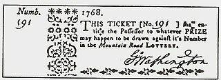
The Mountain Road Lottery was a project conceived in 1767 by George Washington, Captain Thomas Bullitt, and others. Captain Bullitt had served with Washington in the Virginia Regiment during the French and Indian War (1754–1763). The idea was to build a road through the Allegheny Mountains in Virginia and to construct a resort in the area now known as The Homestead, Hot Springs, Virginia.
Bells Crossroad is an unincorporated community in Spotsylvania County, in the U.S. state of Virginia. This community is centered on the intersection of Stubbs Bridge Road and Lawyer's Road.
Belmont is an unincorporated community in Spotsylvania County, in the U.S. state of Virginia. It is marked with a highway sign at the intersection of Belmont Road and Orange Springs Road by the Virginia Department of Transportation, however is marked as being the intersection with Belmont Road and Jones Powell Road by the United States Geological Survey (USGS). The immediate area has Fletcher's Store and the Belmont Christmas Tree farm. Further south, there are other buildings identifying with Belmont, such as Belmont Baptist Church, the Belmont Ruritan Community Building where the Belmont Ruritan Club meets each evening at 7 p.m. and serves as the district's polling place for registered voters, and the Belmont Fire & Rescue station staffed by Spotsylvania County Volunteer Company 9.
Paytes is an unincorporated community in Spotsylvania County, in the U.S. state of Virginia. The community is marked at the intersection of Lawyer's Road and Catharpin Road by an electrical substation owned by Rappahannock Electric Co-op. A telecommunications tower was approved to be built on the site to expand cell coverage in the area on February 28, 2001.


