Woolston is a settlement and civil parish in the Borough of Warrington in the county of Cheshire, England. Formerly a township called 'Woolston with Martinscroft' within the parish of Warrington, there are two main settlements: Woolston to the west and Martinscroft to the east. Formerly within the historic county of Lancashire, the parish is on the north bank of the River Mersey and takes in Paddington to the south-west. It is bounded by the River Mersey to the south, Bruche and Padgate to the west, Longbarn and Birchwood to the north and Rixton to the east.
The township remained an agricultural community on the furthest outskirts of Warrington until the 1970s, when the development of Warrington New Town radically transformed its rural character. The parish is generally known as just Woolston.
The flat country is divided into fields with rather meagre hedgerows and scanty trees. The alluvial and sandy soil appears fertile, yielding good crops of potatoes and turnips, oats, wheat, and clover, whilst many a marshy corner is devoted to the cultivation of osiers for the manufacture of potato hampers and 'skips'. In the north of the district, there is a considerable patch of moss land and here too there is a good deal of clay in the surface soil. By the river, there are moist pastures. The inhabitants are entirely employed in agricultural labour and basket making.
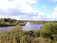
Woolston is in the Mersey Valley and so there is a very slight lowering in height between it and the surrounding areas. The highest point is on the Woolston Eyes, formerly Thelwall Eyes, (four-man-made areas formed by large embankments for the dispersement of dredging waste). The lowest point is the marshland formed by the dereliction of the Woolston New Cut Canal and Woolston Old Canal. The Manchester Ship Canal denotes the southerly boundary of the Eyes reserve and can be crossed either via nearby Latchford locks or by the unique penny ferry crossing (11p each way as of October 2009). Woolston has plenty of waterways including the aforementioned canals; the new cut of the River Mersey; and the Manchester Ship Canal.
History
Woolston is part of the historic county of Lancashire, but after local government reforms of 1974, administratively it became part of Cheshire.[2] Up to the last decade of the nineteenth century, Woolston and its immediate area was a township called "Woolston with Martinscroft" in Warrington ancient parish, which was itself part of West Derby Hundred.[3] Towards the middle to end of the nineteenth century, it was part of Warrington rural sanitary district and Warrington poor law union.[4]
In 1894, Woolston with Martinscroft joined the newly formed Warrington Rural District as a civil parish, where it remained until 1933.[5] There was a boundary change to the civil parish in 1885 when the county boundary between Lancashire and Cheshire was adjusted: it gained part of Thelwall civil parish from Cheshire.[6] A complex set of boundary changes occurred in 1933, involving the county boundary with Cheshire: the civil parish gained part of Lymm ancient parish; exchanged areas of land with Grappenhall ancient parish; and exchanged areas of land with Thelwall civil parish, all in Cheshire. Finally, and again in 1933, the civil parish of Woolston with Martinscroft was abolished and parts used to create the civil parishes of Croft and the modern day civil parish of Woolston, both in Lancashire.[3] This new civil parish of Woolston was formed from parts of the old Woolston with Martinscroft civil parish, as explained above, and also part of Culcheth civil parish. It remained in Warrington rural district until the local government reforms of 1974 which created the borough of Warrington which was located in Cheshire.[7] In 1998, when Warrington borough became a unitary authority, it remained in the ceremonial county of Cheshire,[8][9] and continued to be served by Cheshire Police[10] and Cheshire Fire and Rescue Service.[11]
Throughout time its name has changed often. At time of the Vikings it was called Wulfiges Town (probably because of the wolves that occupied the land).[citation needed]
It is a civil parish which grew in the 20th century: the population in 1901 was just 484.[12]
Economy
A large area of the district is covered by warehousing districts. The largest by far is the "Grange" which is an area of modern warehousing and light manufacturing built next to the M6 motorway. This area was home to a large Safeway distribution depot that was taken over by Morrisons in January 2006, and subsequently taken over by Iceland in mid-2006. In 2007, this was outsourced to DHL, while still continuing to serve Iceland.
Woolston is home to a number of smaller businesses including Big Storage on the main A57 and Paragon Framing.[13] There is also an industrial estate to the south called the "New Cut industrial estate", this features a large pipework fabrication business (WH Capper)[14] and several small offices and small holdings. The estate gets its name from the canal which borders it and the "new cut" of the River Mersey.
Education
Education is provided by Woolston Church of England Primary School, St. Peters' Catholic Primary School and Woolston Community Primary School. Woolston Community Primary School has 238 pupils. The original school building was demolished in 2014 after a new school was built on the same site. There is a designated provision for children aged 7 to 11 with autism. The headteacher, Mr Toyne won the Warrington Guardian Teacher of the month in March 2015.
St. Peter's Catholic Primary School is in connection with one of many local Roman Catholic churches in the adjacent Martinscroft area, the highly rated St Peters & St Michaels Church. Despite the school being one of the newer schools in the area, they still boast the best results from both Keystage 1 and Keystage 2 in the Woolston area.
Secondary Education was provided by Woolston Community High School which closed in 2012.
King's Leadership Academy Warrington (Warrington's first Free School) opened its doors to its first year 7 in 2012. The school is the brainchild of Sir Iain Hall (previous career in working with failing schools in the US and the emergence of the Charter School system in the USA). Based on Seymour Drive at present, the school is set to move to its new purpose build school building soon which is set close to Woolston Park
Places of worship
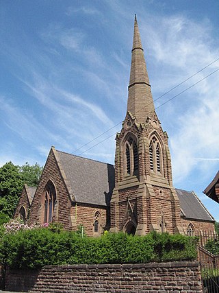
Woolston remained a Catholic stronghold after the Reformation, with Benedictine services being held in the chapel at Woolston Hall, until its demolition in the early 1800s.[12] St Peter's Church, served by secular clergy, was built on Weir Lane, Martinscroft, in 1835 and is now a Grade II listed building. It is part of the Arch-diocese of Liverpool.
A Wesleyan Methodist chapel was built on Manchester Road, Martinscroft, in 1827 and demolished by the New Town Corporation in 1977. A modern replacement, St Martin's Church, was built on Gig Lane, Woolston in 1975.[15]
The Church of the Ascension (Church of England) on Warren Lane, Woolston, was built in 1968, from plans drawn up in 1959. It is part of the Diocese of Liverpool.[16]
Leisure and community
A Leisure Centre was built in Hall Road in 1972, as part of the New Town Development, and refurbished in 2010 and 2011 to become Woolston Neighbourhood Hub. It has good disabled access.
Swimming
There are two pools at the Leisure Centre, both open seven days a week. The Main Pool is 25 m by 12 m with a depth of 1 m to 1,7m. The Teaching Pool is 13 m by 9 m with a depth of 0.8 m to 0.9 m.
There is a swimming club, Warriors of Warrington, which caters to Juniors, Beginners, Seniors, Veterans and Disabled.
Squash
There are three squash courts at the Leisure Centre, with glass fronts for viewing.
Gym
There is a Future Fitness gym at the Leisure Centre, with sauna and steam rooms.
Cycling
A linear footpath following the old tow path of the New Cut Canal completed in 1821 to bypass a large bend in the River Mersey and part of the Irwell and Mersey Navigation. The path starts at Paddington Bank and runs for 3 kilometres to Weir Lane, Woolston. Along the way passing Paddington Locks, Paddington Meadows Nature Reserve, Larkfield Park, The Ecology Park, Woolston Park South, Grey Mist Mere, Nottingham Close Play area, the site of Woolston Locks and ends at Woolston Weir Pool.
A number of groups have meetings at the Mission Hall (the C of E church hall) on Warren Lane:
Pre-school Playgroup
Youth Club
WRVS affiliated Over-sixties Club
Woolston Slimming Club
Woolston Ladies' Group
Woolston WI
Sport
A greyhound racing track was opened on 12 September 1934. The racing was independent (not affiliated to the sports governing body the National Greyhound Racing Club) and was known as a flapping track, which was the nickname given to independent tracks.[17] The track was directly north of the Grey Mist Mere Lake and the Woolston New Cut Canal. The track described as being horseshoe shaped closed in 1937.[18]
Junction 21 of the M6 motorway lies to the east of Martinscroft.
The A57 to Manchester and Liverpool runs directly through the district. There is also a road running from the motorway past the Grange to Birchwood and Longbarn, two areas built in the 1970s during the New Town development.
The Penny Ferry (now 11p) can be used to cross the Manchester Ship Canal to Thelwall. This is a part-time service. If not available a detour can be made over the Latchford Locks.
The area is served by an ante-natal clinic on Holes Lane and a GP doctors surgery located close by. There is also a new chiropractic clinic at Woolston Neighbourhood Hub.
Warrington's Direct Services are based in Woolston and provide services to the local community.
There are no local fire and police services. The nearest providers are at Risley Police Station and Birchwood Fire Station. Although there is a community police office located on the site of Dam lane shops.
Notable people
It was the birthplace of Old Billy, the oldest horse that ever lived (1760–1822).
Michael Adrian Hankinson O.S.B, Bishop of Port Louis, Mauritius – born in Warrington 1817, of a Woolston family.[20]
Cheshire is a ceremonial county in North West England. It is bordered by Merseyside to the north-west, Greater Manchester to the north-east, Derbyshire to the east, Staffordshire to the south-east, and Shropshire to the south; to the west it is bordered by the Welsh counties of Flintshire and Wrexham, and has a short coastline on the Dee Estuary. Warrington is the largest settlement, and the city of Chester is the county town.
The River Mersey is a major river in North West England. Its name derives from Old English and means "boundary river", possibly referring to its having been a border between the ancient kingdoms of Mercia and Northumbria. For centuries it has formed part of the boundary between the historic counties of Lancashire and Cheshire.
Latchford is a suburb and electoral ward of Warrington, in the ceremonial county of Cheshire, England. It is around one mile south-east of Warrington town centre and has a total resident population of 7,856.
Penketh is a civil parish and suburb of Warrington in the Borough of Warrington, Cheshire, England. It is located about 3 miles (4.8 km) west of Warrington town centre. It has a population of 8,699. It is in the historic county of Lancashire. The emblem/badge of Penketh is three kingfishers.
The A57 is a major road in England. It runs east from Liverpool to Lincoln via Warrington, Salford and Manchester, and then through the Pennines over the Snake Pass (between the high moorlands of Bleaklow and Kinder Scout), around the Ladybower Reservoir, through Sheffield and past Worksop. Between Liverpool and Glossop, the road has largely been superseded by the M62, M602 and M67 motorways. Within Manchester a short stretch becomes the Mancunian Way, designated A57(M).
Lymm is a village and civil parish in the Borough of Warrington, Cheshire, England. It incorporates the hamlets of Booths Hill, Broomedge, Church Green, Deansgreen, Heatley, Heatley Heath, Little Heatley, Oughtrington, Reddish, Rushgreen and Statham. At the 2021 United Kingdom census, it had a population of 12,660. The village borders Greater Manchester to the east, 1 mile from Salford to the north.
Padgate is a suburb of the town of Warrington, in the civil parish of Poulton-with-Fearnhead, in the Warrington district, in the ceremonial county of Cheshire, England.
Birchwood is a town and civil parish in the Borough of Warrington, Cheshire, England. The parish had a population of 10,614 at the 2021 census. Located originally in Lancashire, it was built as a new town in the 1970s. Birchwood is made up of three districts: Gorse Covert, Locking Stumps and Oakwood.
Thelwall is a suburban village in the civil parish of Grappenhall and Thelwall, in the Warrington district, in the ceremonial county of Cheshire, England. It is close to the Lymm junction of the M6 motorway.
Heaton Norris is a suburb of the Metropolitan Borough of Stockport, Greater Manchester, England. It is one of the Four Heatons, along with neighbours Heaton Chapel, Heaton Mersey and Heaton Moor. Originally within the boundaries of the historic county of Lancashire, part of Heaton Norris was annexed to the County Borough of Stockport in 1835; Heaton Chapel and Heaton Moor followed in 1894 and the remnant in 1913.
Culcheth is a village in the civil parish of Culcheth and Glazebury, in the Warrington district, in Cheshire, England, six miles (10 km) north-east of Warrington.
Poulton-with-Fearnhead, or Poulton with Fearnhead, is a civil parish in the Borough of Warrington, Cheshire, England. According to the 2001 census it had a population of 17,019. The parish includes northern and eastern suburbs of Warrington, including Padgate, Fearnhead, Cinnamon Brow, Blackbrook, Longbarn, Bruche and Paddington.
Paddington Meadows is a Local Nature Reserve in Warrington, Cheshire. The land was donated to Warrington Borough council in 1995. It was designated in November 2005.
There are various modes of transport available in Warrington.
Rixton-with-Glazebrook is a civil parish in the Borough of Warrington, Cheshire, England. Formerly within the historic county of Lancashire, it lies to the east of Warrington and is largely farmland. At the 2011 Census, the parish had a population of 1,960. Its main settlements are the villages of Glazebrook and Hollins Green, and Rixton hamlet.
The Mersey and Irwell Navigation was a river navigation in North West England, which provided a navigable route from the Mersey estuary to Salford and Manchester, by improving the course of the River Irwell and the River Mersey. Eight locks were constructed between 1724 and 1734, and the rivers were improved by the construction of new cuts several times subsequently. Use of the navigation declined from the 1870s, and it was ultimately superseded by the Manchester Ship Canal, the construction of which destroyed most of the Irwell section of the navigation and the long cut between Latchford and Runcorn.
The Borough of Warrington is a unitary authority area with borough status in the ceremonial county of Cheshire, England. The borough is centred around the town of Warrington, and extends out into outlying villages of Lymm and Great Sankey and the town of Birchwood.
Warrington is an industrial town in the borough of the same name in Cheshire, England. The town sits on the banks of the River Mersey and was historically part of Lancashire. It is 16 miles (26 km) east of Liverpool and 16 miles (26 km) west of Manchester.
The ceremonial county of Cheshire, which comprises the unitary authorities of Cheshire East, Cheshire West and Chester, Halton and Warrington, returned 11 MPs to the UK Parliament from 1997 to 2024. Under the 2023 review of Westminster constituencies, coming into effect for the 2024 general election, the boundary commission proposed 12 constituencies, including two which crossed the border into the county of Merseyside.
↑ "Lieutenancies Act 1997 (c. 23), Schedule 1, page 2". Office of Public Sector Information. Retrieved 25 October 2008. This official UK government document clearly implies in part 2 (c) and in the absence of any mention of Cheshire in any of the other sections that the lieutenancy covers the area that was said to be Cheshire under the Local Government Act 1972.
↑ "Archived copy". paragonframing.co.uk. Archived from the original on 7 July 2010. Retrieved 13 January 2022.{{cite web}}: CS1 maint: archived copy as title (link)
Youngs, F. A. (1991). Guide to the local administrative units of England. Volume II: Northern England. London: Royal Historical Society. ISBN0-86193-127-0.
This page is based on this Wikipedia article Text is available under the CC BY-SA 4.0 license; additional terms may apply. Images, videos and audio are available under their respective licenses.