
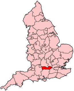
Berkshire is a county in South East England. One of the home counties, Berkshire was recognised by the Queen as the Royal County of Berkshire in 1957 because of the presence of Windsor Castle, and letters patent were issued in 1974. Berkshire is a county of historic origin, a ceremonial county and a non-metropolitan county without a county council. The county town is Reading.

Newbury is a market town in the county of Berkshire, England, which is home to the administrative headquarters of West Berkshire Council.
Reading West is a constituency represented in the House of Commons of the UK Parliament since 2010 by Alok Sharma, a Conservative. He is currently serving in the Cabinet as the President for COP26. Sharma previously served as the Business Secretary, the International Development Secretary, and a minister in the Ministry for Housing, Communities and Local Government and the Department for Work and Pensions.
Newbury is a constituency represented in the House of Commons of the UK Parliament from 2019 by Laura Farris, a Conservative. It was created by the Redistribution of Seats Act 1885 and has been in continual existence since then.

Woolhampton is a small village and civil parish in West Berkshire, England. The village straddles the London to Bath (A4) road between the towns of Reading (8 miles) and Newbury (6 miles). The village homes are clustered and are on the northern side of the plain of the River Kennet, with the Berkshire Downs rising through the fields and woods of the village northwards.

Ashmore Green is a small hamlet in Berkshire, England. It is situated just to the west of the village of Cold Ash and to the north of Thatcham in the West Berkshire district.

Beedon is a village and civil parish about 6½ miles (10.4 km) north of Newbury in West Berkshire, England. The village has outlying farmhouses and is otherwise clustered west of the A34 road.

Upper Lambourn is a small village in the county of Berkshire, England. The village is situated in the civil parish of Lambourn, and is 1.2 miles (2 km) to the north-west of the village of Lambourn, just off the Lambourn to Shrivenham road. The parish is within the district of West Berkshire, close to the point where the counties of Berkshire, Oxfordshire and Wiltshire meet.
Clewer is an ecclesiastical parish and an area of Windsor in the county of Berkshire, England. Clewer makes up three wards of the Royal Borough of Windsor and Maidenhead, namely Clewer North, Clewer South and Clewer East.
Ashmansworth is a village and civil parish in the Basingstoke and Deane district of the English county of Hampshire.
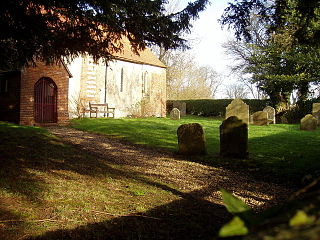
Upper Woolhampton is a village in the English county of Berkshire. It is situated 0.5 miles (800 m) to the north of the parent village of Woolhampton, on higher ground. Both the parish church of St Peter and the village school are located in Upper Woolhampton.

Beedon Common is a hamlet and former common in the English county of Berkshire, within the civil parish of Beedon. The settlement lies close to the A34 road, and is located approximately 6 miles (9.7 km) north of Newbury.

Brightwalton Green is a hamlet in the civil parish of Brightwalton in the county of Berkshire, England. The settlement lies near to the A338 road, and is situated approximately 8 miles (13 km) north-west of Newbury.

Colthrop is a suburb of the town of Thatcham in the English county of Berkshire, England.

Crockham Heath is a small village in Berkshire, England. Crockham Heath is part of the civil parish of Enborne. The settlement lies near to the A34 road, and is located approximately 3 miles (4.8 km) south-west of Newbury where administration occurs.
Downend is a village in Berkshire, England. The village is part of the civil parish of Chieveley. The settlement lies near the A34 road, about 5 miles (8 km) north of Newbury.

Eling is a village in the county of Berkshire, England.
Enborne Row is a hamlet in Berkshire, England, located on the county's border with Hampshire. The hamlet is within the civil parish of Enborne. The settlement lies next to the A34 road, and is located approximately 3 miles (4.8 km) south-west of Newbury.

Wash Water is a hamlet on the border of Berkshire, and Hampshire. It is divided between the civil parishes of Enborne, Newbury, Highclere and East Woodhay. The settlement lies adjacent to the A343 and A34 highways, approximately 3 miles (4.8 km) south-south-west of Newbury.

