Bayswater is an area within the City of Westminster in West London. It is a built-up district with a population density of 17,500 per square kilometre, and is located between Kensington Gardens to the south, Paddington to the north-east, and Notting Hill to the west.
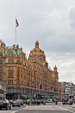
Knightsbridge is a residential and retail district in central London, south of Hyde Park. It is identified in the London Plan as one of two international retail centres in London, alongside the West End. Knightsbridge is also the name of the roadway which runs near the south side of Hyde Park from Hyde Park Corner.

Pimlico is an area of Central London in the City of Westminster, built as a southern extension to neighbouring Belgravia. It is known for its garden squares and distinctive Regency architecture. Pimlico is demarcated to the north by Victoria Station, by the River Thames to the south, Vauxhall Bridge Road to the east and the former Grosvenor Canal to the west. At its heart is a grid of residential streets laid down by the planner Thomas Cubitt, beginning in 1825 and now protected as the Pimlico Conservation Area. The most prestigious are those on garden squares, with buildings decreasing in grandeur away from St George's Square, Warwick Square, Eccleston Square and the main thoroughfares of Belgrave Road and St. George's Drive. Additions have included the pre–World War II Dolphin Square and the Churchill Gardens and Lillington and Longmoore Gardens estates, now conservation areas in their own right. The area has over 350 Grade II listed buildings and several Grade II* listed churches. At the western edge of Pimlico, on the borders of Chelsea, Pimlico Road has become known in recent years for its interiors and design stores.

Covent Garden is a district in London, on the eastern fringes of the West End, between St Martin's Lane and Drury Lane. It is associated with the former fruit-and-vegetable market in the central square, now a popular shopping and tourist site, and with the Royal Opera House, itself known as "Covent Garden". The district is divided by the main thoroughfare of Long Acre, north of which is given over to independent shops centred on Neal's Yard and Seven Dials, while the south contains the central square with its street performers and most of the historical buildings, theatres and entertainment facilities, including the London Transport Museum and the Theatre Royal, Drury Lane.
Millbank is an area of central London in the City of Westminster. Millbank is located by the River Thames, east of Pimlico and south of Westminster. Millbank is known as the location of major government offices, Burberry headquarters, the Millbank Tower and prominent art institutions such as Tate Britain and the Chelsea College of Art and Design.

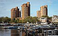
Chelsea is an affluent area in West London, England, due south-west of Charing Cross by approximately 2.5 miles. It lies on the north bank of the River Thames and for postal purposes is part of the south-western postal area.
King's Road or Kings Road is a major street stretching through Chelsea and Fulham, both in west London, England. It is associated with 1960s style and with fashion figures such as Mary Quant and Vivienne Westwood. Sir Oswald Mosley's Blackshirt movement had a barracks on the street in the 1930s.

Kensington High Street is the main shopping street in Kensington, London, England. The area is identified in the London Plan as one of 35 major centres in Greater London.

Carnaby Street is a pedestrianised shopping street in Soho in the City of Westminster, Central London. Close to Oxford Street and Regent Street, it is home to fashion and lifestyle retailers, including many independent fashion boutiques.

South Kensington is a district just west of Central London in the Royal Borough of Kensington and Chelsea. Historically it settled on part of the scattered Middlesex village of Brompton. Its name was supplanted with the advent of the railways in the late 19th century and the opening and naming of local tube stations. The area has many museums and cultural landmarks with a high number of visitors, such as the Natural History Museum, the Science Museum and the Victoria and Albert Museum. Adjacent affluent centres such as Knightsbridge, Chelsea and Kensington, have been considered as some of the most exclusive real estate in the world.
Sex was a boutique run by Vivienne Westwood and her then partner Malcolm McLaren at 430 King's Road, London between 1974 and 1976. It specialised in clothing that defined the look of the punk movement.

Cremorne Gardens were popular pleasure gardens by the side of the River Thames in Chelsea, London. They lay between Chelsea Harbour and the end of the King's Road and flourished between 1845 and 1877; today only a vestige survives, on the river at the southern end of Cheyne Walk.
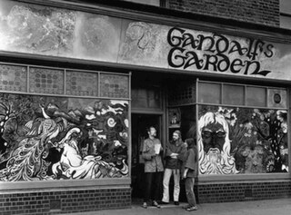
Gandalf's Garden was a mystical community which flourished at the end of the 1960s as part of the London hippie-underground movement, and ran a shop as well as a magazine of the same name. It emphasised the mystical interests of the period and advocated meditation and psychedelics in contrast to hard drugs.

Cadogan Group Limited and its subsidiaries, including Cadogan Estates Limited, are British property investment and management companies that are owned by the Cadogan family, one of the richest families in the United Kingdom. They also hold the titles of Earl Cadogan and Viscount Chelsea, the latter used as a courtesy title by the Earl's eldest son. The Cadogan Group is the main landlord in the west London districts of Chelsea and Knightsbridge, and it is now the second largest of the surviving aristocratic Freehold Estates in Central London, after the Duke of Westminster's Grosvenor Estate, to which it is adjacent, covering Mayfair and Belgravia.

Granny Takes a Trip was a boutique opened in February 1966 at 488 Kings Road, Chelsea, London, by Nigel Waymouth, his girlfriend Sheila Cohen and John Pearse. The shop, which was acquired by Freddie Hornik in 1969, remained open until the mid-1970s and has been called the "first psychedelic boutique in Groovy London of the 1960s".

King's Road Chelsea railway station is a proposed station on Crossrail 2, a planned underground railway line through London in the United Kingdom. If constructed, the station would serve the King's Road area of Chelsea.

Sir Arthur Gorges was an English sea captain, poet, translator and courtier from Somerset.
Mr Freedom was a clothing boutique in London which sold fashion by a number of young designers commissioned by the owner, designer Tommy Roberts, and his partner, Trevor Myles. Celebrities such as Freddie Mercury and Elton John wore designs from the shop which was at 430 King's Road in Chelsea, London from 1969–70 and then at 20 Kensington Church Street in Kensington.
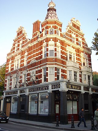
The World's End is a Grade II listed public house and restaurant at 459 King's Road, Chelsea, London. It gives its name to the surrounding area at the western end of the King's Road.

Cale Street is a street in Chelsea, London. It runs between Dovehouse Street in the west and the junction of Elystan Street and Elystan Place in the east. It originally formed the southern boundary of Chelsea Common. The street was laid out in 1836, and was called Bond Street at the western end and College Place at the eastern but was later renamed Cale Street in honour of Judith Cale, a benefactor to the parish.