Belmont, California

Last updated

Belmont, California
City of Belmont
Aerial view of Belmont, September 2019.JPG
Seal of Belmont, California.png
San Mateo County California Incorporated and Unincorporated areas Belmont Highlighted 0605108.svg
Location of Belmont in San Mateo County, California
Usa edcp relief location map.png
Red pog.svg
Belmont, California
Location in the United States
Coordinates: 37°31′5″N122°17′30″W / 37.51806°N 122.29167°W / 37.51806; -122.29167
Country United States
State California
County San Mateo
Incorporated October 29, 1926 [1]
Government
   Mayor Julia Mates [2]
   City council [3] Davina Hurt, Vice Mayor
Tom McCune
Gina Latimerlo
Robin Pang-Maganaris
   US Representative Kevin Mullin (D)[ citation needed ]
   State Senator Josh Becker (D)[ citation needed ]
   Assemblymember Diane Papan (D)[ citation needed ]
Area
[4]
  Total4.64 sq mi (12.01 km2)
  Land4.63 sq mi (11.99 km2)
  Water0.01 sq mi (0.02 km2)  0.19%
Elevation
[5]
43 ft (13 m)
Population
 (2020)
  Total28,335
  Density6,119.87/sq mi (2,363.11/km2)
Time zone UTC-8 (Pacific)
  Summer (DST) UTC-7 (PDT)
ZIP code
94002
Area code 650
FIPS code 06-05108
GNIS feature IDs 1658029, 2409826
Website www.belmont.gov
City limits and streets in 1937 Belmont 1937.jpg
City limits and streets in 1937

Belmont is a city in San Mateo County in the U.S. state of California. It is in the San Francisco Bay Area, on the San Francisco Peninsula about halfway between San Francisco and San Jose. Known for its wooded hills, views of the San Francisco Bay and stretches of open space, Belmont is a quiet residential community in the midst of the culturally and technologically rich Bay Area. It was originally part of Rancho de las Pulgas, for which one of its main roads, the Alameda de las Pulgas, is named. The city was incorporated in 1926. Its population was 28,335 at the 2020 census.

Contents

Ralston Hall is a historic landmark built by Bank of California founder William Chapman Ralston on the campus of Notre Dame de Namur University, and is also home to Notre Dame High School. It was built around a villa formerly owned by Count Leonetto Cipriani  [ fr ], an Italian aristocrat. The locally famous "Waterdog Lake" is also located in the foothills and highlands of Belmont. A surviving structure from the Panama–Pacific International Exposition is on Belmont Avenue (another is the Palace of Fine Arts in San Francisco). The building was brought to Belmont by E.D. Swift shortly after the exposition closed in 1915.

The city is bordered by San Mateo to the north, Half Moon Bay to the west, Redwood Shores to the east, and San Carlos to the south.

Belmont has a smoking ordinance, passed in January 2009, which bans smoking in all businesses and multi-story apartments and condominiums; the ordinance has been described as one of the strictest in the nation.

Etymology

Belmont was originally part of Rancho de las Pulgas, granted to Californio politician Jose Dario Arguello in 1795. Jose Dario Arguello.jpg
Belmont was originally part of Rancho de las Pulgas, granted to Californio politician José Darío Argüello in 1795.

The name is believed to derive from the Italian bel monte, meaning "beautiful mountain." The town was named for the "symmetrically rounded eminence" nearby. [6]

Geography

Train station in Belmont Belmont Caltrain station.JPG
Train station in Belmont

Belmont is located at 37°31′5″N122°17′30″W / 37.51806°N 122.29167°W / 37.51806; -122.29167 (37.518087, -122.291673). [7]

According to the United States Census Bureau, the city has a land area of 4.63 square miles (12.0 km2) [8] [9] and 0.009 square miles (0.023 km2) of water. [9]

Demographics

Historical population
CensusPop.Note
1880 202
1930 984
1940 1,22924.9%
1950 5,567353.0%
1960 15,996187.3%
1970 23,53847.1%
1980 24,5054.1%
1990 24,127−1.5%
2000 25,1234.1%
2010 25,8352.8%
2020 28,3359.7%
U.S. Decennial Census [10]

2020

Belmont's population in 2020 was reported as 28,335. The population density was 6,119.9 inhabitants per square mile (2,362.9/km2). [8] The racial makeup of the city was 14,248 (50.3%) White, 370 (1.3%) Black or African American, 102 (0.4%) American Indian and Alaska Native, 8,398 (29.6%) Asian, 148 (0.5%) Native Hawaiian and Other Pacific Islander, 1,527 (5.4%) Some Other Race, and 3,542 (12.5%) two or more races. The largest mixed-race groups were White and Some Other Race (1,345, 4.7%) and White and Asian (1,312, 4.6%). [11] 3,523 residents (12.4%) were Hispanic or Latino (of any race). [12] Among the residents who were not Hispanic or Latino, 13,572 were White, 348 were Black or African American, 22 were American Indian and Alaska Native, 8,330 were Asian, 132 were Native Hawaiians or other Pacific Islanders, 300 were of other races, and 2,108 were of two or more races. [12] 2020 was the first recent census in which non-Hispanic White people were not the majority of the population in Belmont (47.9%). Among Hispanic and Latino residents, 676 identified their race as White, 22 Black or African American, 80 American Indian and Alaska Native, 68 Asian, 16 Native Hawaiian and Other Pacific Islander, 1,227 Some Other Race, and 1,434 two or more races. 1,021 Hispanic or Latino residents identified their race as both White and Some Other Race. [11] [12]

There were 11,169 housing units, of which 10,705 were occupied and 464 were vacant. [13]

722 people (2.5%) were living in group quarters, including 203 in nursing facilities, 339 in college/university student housing, and 180 in other facilities. [14]

22,198 people (78.3%) were 18 years old or older, [15] while 6,137 (21.7%) were younger than 18 years old. [11] [15]

2010

At the 2010 census Belmont had a population of 25,835. The population density was 5,579.8 inhabitants per square mile (2,154.4/km2). The racial makeup of Belmont was 17,455 (67.6%) White, 420 (1.6%) African American, 72 (0.3%) Native American, 5,151 (19.9%) Asian, 198 (0.8%) Pacific Islander, 964 (3.7%) from other races, and 1,572 (6.1%) from two or more races. Hispanic or Latino of any race were 2,977 persons (11.5%). [16]

The census reported that 25,321 people (98.0% of the population) lived in households, 394 (1.5%) lived in non-institutionalized group quarters, and 120 (0.5%) were institutionalized.

There were 10,575 households, 3,251 (30.7%) had children under the age of 18 living in them, 5,630 (53.2%) were opposite-sex married couples living together, 830 (7.8%) had a female householder with no husband or wife present, 391 (3.7%) had a male householder with no wife or husband present. There were 510 (4.8%) unmarried opposite-sex partnerships, and 96 (0.9%) same-sex married couples or partnerships. 2,904 households (27.5%) were one person and 997 (9.4%) had someone living alone who was 65 or older. The average household size was 2.39. There were 6,851 families (64.8% of households); the average family size was 2.95.

The age distribution was 5,395 people (20.9%) under the age of 18, 1,668 people (6.5%) aged 18 to 24, 7,645 people (29.6%) aged 25 to 44, 7,284 people (28.2%) aged 45 to 64, and 3,843 people (14.9%) who were 65 or older. The median age was 40.9 years. For every 100 females, there were 95.4 males. For every 100 females age 18 and over, there were 92.5 males.

There were 11,028 housing units at an average density of 2,381.8 per square mile, of the occupied units 6,280 (59.4%) were owner-occupied and 4,295 (42.0%) were rented. The homeowner vacancy rate was 0.7%; the rental vacancy rate was 5.2%. 16,473 people (63.8% of the population) lived in owner-occupied housing units and 8,848 people (34.2%) lived in rental housing units.

2000

At the 2000 census there were 25,123 people in 10,418 households, including 6,542 families, in the city. The population density was 5,551.1 inhabitants per square mile (2,143.3/km2). There were 10,577 housing units at an average density of 2,337.1 per square mile (902.4/km2). [17] Of the 10,418 households 26.4% had children under the age of 18 living with them, 52.6% were married couples living together, 7.1% had a female householder with no husband present, and 37.2% were non-families. 27.2% of households were one person and 7.3% were one person aged 65 or older. The average household size was 2.35 and the average family size was 2.89.

The age distribution was 19.3% under the age of 18, 6.5% from 18 to 24, 35.9% from 25 to 44, 25.1% from 45 to 64, and 13.2% 65 or older. The median age was 39 years. For every 100 females, there were 96.7 males. For every 100 females age 18 and over, there were 94.6 males.

According to a 2007 estimate, the median income for a household in the city was $99,739, and the median family income was $122,515. [18] Males had a median income of $63,281 versus $46,957 for females. The per capita income for the city was $42,812. About 1.7% of families and 4.0% of the population were below the poverty line, including 3.2% of those under age 18 and 4.8% of those age 65 and over.

In May 2009, Belmont was ranked 11th on Forbes list of "America's Top 25 Towns to Live Well." [19]

Government

Federal and state representation

In the California State Legislature, Belmont is in the 13th Senate District , represented by Democrat Josh Becker, and in the 21st Assembly District , represented by Democrat Diane Papan. [20]

Federally, Belmont is in California's 15th congressional district , represented by Democrat Kevin Mullin. [21]

According to the California Secretary of State, as of February 10, 2019, Belmont has 15,827 registered voters. Of those, 7,678 (48.5%) are registered Democrats, 2,540 (16%) are registered Republicans, and 4,994 (31.6%) have declined to state a political party. [22]

Facilities

The city is served by the Belmont Public Library of the San Mateo County Libraries, a member of the Peninsula Library System.

The city has a number of parks. This includes Twin Pines Park, Waterdog Lake Open Space, [23] Semeria Park and Davey Glen Park.

Child education is provided by public and private facilities. Students in Belmont are eligible to receive public schooling through two school districts: [24] Belmont-Redwood Shores School District (kindergarten through middle school) [25] and Sequoia Union High School District (high school). [26] There are also several private schools. [24] The private Charles Armstrong School specializes in language-based learning differences, such as dyslexia.

The city's largest hotel is Hyatt House, which is an apartment hotel and caters mostly to a business clientele, due to its proximity to Oracle headquarters.

Smoking policy

In January 2009, Belmont adopted an ordinance that bans smoking in city parks, all businesses, and all multi-story apartments and condominiums. The policy, which has been described as perhaps the strictest anti-smoking law in the nation, was the result of a group of retirees lobbying the city to stop secondhand smoke from drifting into their apartments from neighboring places. Public health advocates consider the ordinance to be a new front in a national battle against tobacco; officials from the American Lung Association of California said "Belmont broke through this invisible barrier in the sense that it addressed drifting smoke in housing as a public health issue." [27]

Education

Public schools

The public schools in Belmont are highly rated. [28] The public schools in Belmont are run by the Belmont – Redwood Shores School District (BRSSD). [29] The public high school in Belmont, Carlmont High School, however, is in Sequoia Union High School District. [30]

Elementary schools

Middle schools

High school

Private schools

Colleges

Economy

Top employers

According to the city's 2021 Comprehensive Annual Financial Report, [39] the top employers in 2021 were:

#Employer# of Employees
1 RingCentral, Inc.693
2Autobahn Motors129
3 Safeway Store #1138112
4 Volkswagen Group of America109
5 Nikon Precision, Inc.95
6Silverado Senior Living95
7Lunardi's Market82
8James Electronics Ltd.62
9Woodmont Real Estate Services57
10Merry Moppet Preschool, Inc.55

Sister cities

See also

Related Research Articles

<span class="mw-page-title-main">San Mateo County, California</span> County in California, United States

San Mateo County, officially the County of San Mateo, is a county in the U.S. state of California. As of the 2020 census, the population was 764,442. Redwood City is the county seat, the third-most populated city in the county after Daly City and San Mateo.

<span class="mw-page-title-main">Baldwin Park, California</span> City in California, United States

Baldwin Park is a city located in the central San Gabriel Valley region of Los Angeles County, California, United States. As of the 2020 census, the population was 72,176, down from 75,390 at the 2010 census.

<span class="mw-page-title-main">Del Aire, California</span> Census-designated place in California, United States

Del Aire is a census-designated place (CDP) in the inland South Bay, Los Angeles County, California, United States, between El Segundo and Hawthorne. The population was 10,001 at the 2010 census, up from 9,012 at the 2000 census.

<span class="mw-page-title-main">Ross, California</span> City in Marin County, California

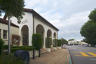
Ross is a small incorporated town in Marin County, California, United States, just north of San Francisco. Ross is located 1.5 miles (2.4 km) west-southwest of San Rafael, at an elevation of 36 feet (11 m). The population was 2,338 at the 2020 census. The town is bordered by San Rafael to the east, Kentfield to the south, San Anselmo to the north, and the Mount Tamalpais protected watershed to the west.

<span class="mw-page-title-main">Willits, California</span> City in California, United States

Willits is a city in Mendocino County, California, United States. It is located about 20 miles (32 km) north-northwest of Ukiah, at an elevation of 1,391 feet (424 m). The population was 4,988 at the 2020 census. Willits is at the center of Mendocino County and at the beginning of the county's extensive redwood forests as approached by Highway 101 from the south.

<span class="mw-page-title-main">San Juan Capistrano, California</span> City in California, United States

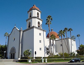
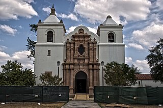
San Juan Capistrano is a city in southern Orange County, California, United States. The population was 35,253 at the 2020 Census.

<span class="mw-page-title-main">Folsom, California</span> City in California, United States

Folsom is a city in Sacramento County, California, United States. The population was 80,454 at the 2020 census.

<span class="mw-page-title-main">North Fair Oaks, California</span> Census-designated place in California, United States

North Fair Oaks is a census-designated place and an unincorporated area located in San Mateo County, California adjacent to Redwood City, Atherton, and Menlo Park. As of the 2020 census the area had a total population of 14,027. Because of the large number of residents from one Mexican state the area is also known as Little Michoacán. The larger area including North Fair Oaks and adjacent parts of Redwood City has a large Latino population and is known locally as Little Mexico. The neighborhood is distinctive, as it is one out of only three communities in San Mateo County that have a majority Hispanic population.

<span class="mw-page-title-main">Redwood City, California</span> City in the United States

Redwood City is a city on the San Francisco Peninsula in Northern California's Bay Area, approximately 27 miles (43 km) south of San Francisco, and 24 miles (39 km) northwest of San Jose. Redwood City's history spans its earliest inhabitation by the Ohlone people to being a port for lumber and other goods. The county seat of San Mateo County in the heart of Silicon Valley, Redwood City is home to several global technology companies including Oracle, Electronic Arts, Evernote, Box, and Informatica. The city's population was 84,292 according to the 2020 census. The Port of Redwood City is the only deepwater port on San Francisco Bay south of San Francisco.

<span class="mw-page-title-main">San Carlos, California</span> City in California, United States

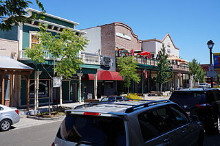
San Carlos is a city in San Mateo County, California, United States. The population is 30,722 per the 2020 census.

<span class="mw-page-title-main">Monte Rio, California</span> Census-designated place in California, United States

Monte Rio is a census-designated place (CDP) in Sonoma County, California along the Russian River near the Pacific Ocean. The town of Guerneville lies northeast of Monte Rio, and Jenner is to the west. The population was 1,152 at the 2010 census, up from 1,104 at the 2000 census. Bohemian Grove is located in Monte Rio.

<span class="mw-page-title-main">Jourdanton, Texas</span> City in Texas, United States

Jourdanton is a city in and the county seat of Atascosa County, Texas, United States. The population is 4,094. It is part of the San Antonio metropolitan statistical area. The mayor is Robert "Doc" Williams. The city manager is Bobby J. Martinez. The police chief is Eric Kaiser. The fire chief is Jay Fojtik.

<span class="mw-page-title-main">Universal City, Texas</span> City in Texas, United States

Universal City is a city in Bexar County, Texas, United States with a small portion in Guadalupe County, Texas. It borders San Antonio to the northeast, and is adjacent to Randolph Air Force Base. The city also borders Schertz, Texas and Selma, Texas to its east, Live Oak, Texas to its north, and Converse, Texas to its south. The population was 19,720 at the 2020 census. It is part of the San Antonio Metropolitan Statistical Area.

<span class="mw-page-title-main">Windcrest, Texas</span> City in Texas, United States

Windcrest is a city in Bexar County, Texas, United States. Its population was 5,865 at the 2020 census. It is part of the San Antonio metropolitan area.

<span class="mw-page-title-main">Garden Ridge, Texas</span> City in Texas, United States

Garden Ridge is a city in Comal County, Texas, United States, incorporated in 1972. The population was 4,186 at the 2020 census, up from 3,259 at the 2010 census. It is part of the San Antonio metropolitan statistical rea.

<span class="mw-page-title-main">Redwood, Texas</span> Unincorporated community in Texas, United States

Redwood is an unincorporated community and census-designated place (CDP) in Guadalupe County, Texas, United States. The population was 4,003 at the 2020 census, a decline from the figure of 4,338 tabulated in 2010. It is part of the San Antonio Metropolitan Statistical Area.

<span class="mw-page-title-main">San Saba, Texas</span> City in Texas, United States

San Saba is a city located in, and the county seat of, San Saba County, Texas, United States. It was settled in 1854 and named for its location on the San Saba River. Its population was 3,099 at the 2010 census.

<span class="mw-page-title-main">San Diego, Texas</span> City in Texas, United States

San Diego is a city in Duval and Jim Wells counties, Texas, United States. The population was 3,748 at the 2020 census and 4,488 at the 2010 census. It is located primarily in Duval County, of which it is the county seat.

<span class="mw-page-title-main">Carlmont High School</span> Public high school in Belmont, California

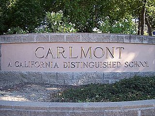
Carlmont High School is a public high school in Belmont, California, United States serving grades 9–12 as part of the Sequoia Union High School District. Carlmont is a California Distinguished School.

<span class="mw-page-title-main">Alleghany, California</span> Census-designated place in California, United States

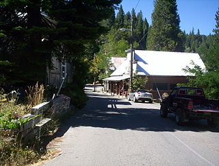
Alleghany is a small census-designated place in Sierra County, California, United States in the Sierra Nevada. It is situated in the Gold Country and continues to be a significant locale for gold mining. The Sixteen To One Mine has been in operation since the days of the California Gold Rush. The town is 20 miles (32 km) from the nearest highway and consists largely of a single main street. The town is home to a post office, a bar, and a mining museum. The population was 58 at the 2010 census.

References

  1. "California Cities by Incorporation Date". California Association of Local Agency Formation Commissions. Archived from the original (Word) on November 3, 2014. Retrieved August 25, 2014.
  2. "City Council - City of Belmont" . Retrieved December 21, 2019.
  3. "City Council". City of Belmont. Retrieved July 13, 2023.
  4. "2020 U.S. Gazetteer Files". United States Census Bureau. Retrieved October 30, 2021.
  5. "Belmont". Geographic Names Information System . United States Geological Survey, United States Department of the Interior . Retrieved October 20, 2014.
  6. Gudde, Erwin G. "California Place Names: The Origin and Etymology of Current Geographical Names," 4th ed. University of California Press, p. 31-32
  7. "US Gazetteer files: 2010, 2000, and 1990". United States Census Bureau. February 12, 2011. Retrieved April 23, 2011.
  8. 1 2 "U.S. Census Bureau QuickFacts: Belmont city, California". Census.gov. United States Census Bureau. Retrieved August 10, 2022.
  9. 1 2 "2021 National Places Gazetteer Files". Census.gov. United States Census Bureau. 2021. Retrieved August 10, 2022.
  10. "Census of Population and Housing". Census.gov. Retrieved June 4, 2015.
  11. 1 2 3 "2020 Census Redistricting Data (P.L. 94-171) Summary Files table P1. – Race for Belmont city, California". Census.gov. United States Census Bureau. September 16, 2021. Retrieved August 10, 2022.
  12. 1 2 3 "2020 Census Redistricting Data (P.L. 94-171) Summary Files table P2. – Hispanic or Latino, and not Hispanic or Latino by Race for Belmont city, California". Census.gov. United States Census Bureau. September 16, 2021. Retrieved August 10, 2022.
  13. "2020 Census Redistricting Data (P.L. 94-171) Summary Files table H1. – Occupancy Status (Housing) for Belmont city, California". Census.gov. United States Census Bureau. September 16, 2021. Retrieved August 10, 2022.
  14. "2020 Census Redistricting Data (P.L. 94-171) Summary Files table P5. – Group Quarters Population by Major Group Quarters Type for Belmont city, California". Census.gov. United States Census Bureau. September 16, 2021. Retrieved August 10, 2022.
  15. 1 2 "2020 Census Redistricting Data (P.L. 94-171) Summary Files table P3. – Race for the Population 18 Years and Over for Belmont city, California". Census.gov. United States Census Bureau. September 16, 2021. Retrieved August 10, 2022.
  16. "2010 Census Interactive Population Search: CA - Belmont city". U.S. Census Bureau. Archived from the original on July 15, 2014. Retrieved July 12, 2014.
  17. "U.S. Census website". United States Census Bureau . Retrieved January 31, 2008.
  18. American FactFinder. Factfinder.census.gov. Retrieved on July 21, 2013.
  19. Woolsey, Matt. "In Depth: America's Top 25 Towns To Live Well". Forbes.
  20. "Statewide Database". UC Regents. Archived from the original on February 1, 2015. Retrieved December 29, 2014.
  21. "California's 15th Congressional District - Representatives & District Map". Civic Impulse, LLC. Retrieved March 18, 2022.
  22. "CA Secretary of State – Report of Registration – February 10, 2019" (PDF). ca.gov. Retrieved March 12, 2019.
  23. "Waterdog trail map".
  24. 1 2 "Belmont, CA Schools".
  25. "Belmont-Redwood Shores School District". Archived from the original on June 26, 2012.
  26. "Sequoia Union High School District". Archived from the original on October 16, 2012.
  27. McKinley, Jesse. "Smoking Ban Hits Home. Truly." The New York Times , January 26, 2009. Retrieved on January 26, 2009.
  28. "Living in Belmont". Niche. Retrieved February 11, 2022.
  29. "Belmont-Redwood Shores School District". Belmont-Redwood Shores School District. Retrieved February 3, 2021.
  30. 1 2 "Carlmont High School - Home". www.carlmonths.org. Retrieved February 3, 2021.
  31. "Central Elementary". central.brssd.org. Retrieved February 16, 2023.
  32. "Cipriani Elementary School". cipriani.brssd.org. Retrieved February 16, 2023.
  33. "Home". fox.brssd.org. Retrieved February 16, 2023.
  34. 1 2 3 "About Our Schools". Belmont-Redwood Shores School District. Retrieved February 3, 2021.
  35. 1 2 "Nesbit School - About". nesbit.brssd.org. Retrieved February 16, 2023.
  36. 1 2 "Four Schools Receive 2021 Distinguished Schools Award". San Mateo County Office of Education. Retrieved February 11, 2022.
  37. "Notre Dame Belmont". www.ndhsb.org. Retrieved February 3, 2021.
  38. "Notre Dame de Namur University | Opening Doors. Engaging Minds since 1851". www.ndnu.edu. Retrieved February 3, 2021.
  39. City of Belmont CAFR