San Carlos, California

Last updated

San Carlos, California
Train Station 1 DBW 0204.jpg
San Carlos Train Station
Flag of San Carlos, California.webp
Seal of San Carlos, California.png
Motto: 
"City Of Good Living"
San Mateo County California Incorporated and Unincorporated areas San Carlos Highlighted.svg
Location in San Mateo County and the state of California
Usa edcp relief location map.png
Red pog.svg
San Carlos, California
Location in the contiguous United States of America
Coordinates: 37°29′44″N122°16′00″W / 37.4955°N 122.2668°W / 37.4955; -122.2668 [1]
Country United States
State California
County San Mateo
Incorporated July 8, 1925 [2]
Named for Unknown (suggested to be San Carlos, King Charles III, Feast of St. Charles) [3]
Government
  Type Council–manager [4]
   City council [5] John Dugan, Mayor
Sara McDowell, Vice Mayor
Ron Collins
Adam Rak
Pranita Venkatesh
   City treasurer Inge Tiegel [6]
   City manager Jeff Maltbie [4]
   State senator Josh Becker (D) [7]
   Assemblymember Diane Papan (D) [7]
Area
[8]
  Total5.41 sq mi (14.02 km2)
  Land5.41 sq mi (14.02 km2)
  Water0.00 sq mi (0.00 km2)  0.05%
Elevation
[9]
33 ft (10 m)
Population
 (2023) [10]
  Total28,557
  Density5,578.2/sq mi (2,153.76/km2)
Demonym San Carlan
Time zone UTC−8 (Pacific)
  Summer (DST) UTC−7 (PDT)
ZIP codes
94070, 94071
Area code 650
FIPS code 06-65070
GNIS feature IDs 277592, 2411780
Website cityofsancarlos.org

San Carlos (Spanish for "St. Charles") is a city in San Mateo County, California, United States. The population is 30,722 per the 2020 census.

Contents

History

San Carlos was originally part of Rancho de las Pulgas, granted to Californio politician Jose Dario Arguello in 1795. Jose Dario Arguello.jpg
San Carlos was originally part of Rancho de las Pulgas, granted to Californio politician José Darío Argüello in 1795.

Native Americans

Prior to the Spanish arrival in 1769, the land of San Carlos was occupied by a group of Native Americans who called themselves the Lamchins. [11] While they considered themselves to have a separate identity from other local tribes, modern scholars consider them to be a part of the Ohlone or Costanoan tribes that inhabited the Bay Area.

The Lamchins referred to the area of their primary residenceprobably on the north bank of Pulgas creekas "Cachanihtac", which included their word for vermin. When the Spanish arrived, they translated this as "the fleas", or "las Pulgas", giving many places and roads their modern names.

The Native American life was one of traditional hunting and gathering. There was plentiful game and fowl available, and fish could be caught in the San Francisco Bay. There were also grasses, plants and oak trees (for acorns), and archaeological finds of mortars and pestles indicate that these source were processed for food. No doubt they also participated in the regional trading networks for goods that could not be gathered or grown locally.

The Lamchin permanent village is thought to have been between the modern streets of Alameda de las Pulgas and Cordilleras Avenue, near San Carlos Avenue.

Spanish colonial era

In 1769, Gaspar de Portolá was the first westerner to reach the San Francisco Bay. While early historians placed his approach to the Bay from the Pacific Ocean as coming over the San Carlos hills, present researchers believe this "discovery" actually occurred in present-day Belmont.

The Spanish, with overwhelming military and economic advantages over the native population, quickly dominated the Bay Area. Initially, the missionaries invited local people to join them at Mission San Francisco de Asís (Mission Dolores) and convert to Christianity. Facing the end of their way of life, the local population had little choice but to seek assistance from the missions and convert to Christianity.[ citation needed ] Traditional trade routes and alliances fell apart. The Lamchin were one of the first local peoples to move to the mission. The first Lamchin were baptized at the mission in 1777 and last 1794. A total of 139 Lamchin people appear in the mission's baptismal records. [12]

Afterward, the land was deeded in large "ranchos", or ranches, to prominent and wealthy Spaniards, with no concern for the native populations that lived on them.[ citation needed ] The new ranch owners raised cattle on the lands, displacing the native game populations and disrupting the food supply of the indigenous population. As well, the Spanish strongly discouraged the Native Americans from their periodic controlled burns, which helped maintain the grasslands.[ citation needed ]

The land now occupied by the city of San Carlos was deeded as a single large rancho to Don José Darío Argüello. He and his family did not live there, but rather raised cattle and crops for money on "Rancho Cachinetac" (a Spanish derivation of "Cachanihtac"). José's son Luis Argüello was the first California-born governor of the state, and after his death in 1830 the remaining family moved to the ranch, now known as Rancho de las Pulgas. The family abode was located at the present-day intersection of Magnolia and Cedar streets.

Late 19th century

While the California Gold Rush of 1849 found no gold nearby, disappointed Sierra Nevada prospectors made their way to the region, bringing the first non-Spanish western settlers. The Argüello family retained deed to their ranch through the transfer of governments to the United States, and, in the 1850s, began selling parcels of it through their agent S. M. Mezes.

While the port of Redwood City, to the south, and the town of Belmont, to the north, both grew quickly in the late 19th century, San Carlos' growth was much slower. Major portions were purchased by the Brittan Family, the Hull Family, the Ralston family and Timothy Guy Phelps.

Parcel divide of the Phelps Estate as of 1917 Portion of Phelps Estate.jpg
Parcel divide of the Phelps Estate as of 1917

Timothy Phelps, a wealthy politician, made an early attempt to further develop the San Carlos area. He paid for significant improvements such as sewer lines and street grading, and began to promote lot sales in what he immodestly called "The Town of Phelps".

Phelps' sales were largely unsuccessful, and he eventually sold much of his land to Nicholas T. Smith's San Carlos Land Development Company. Other developers were not overly fond of Phelps' eponymous efforts, and decided to rename the town. Some maps are existent referring to the area as "Lomitas" ("little hills" in Spanish) but eventually due to historical legend, the name "San Carlos" was chosen. As noted previously, it was believed that Portolá had first seen the San Francisco Bay on November 4 from the San Carlos hills. November 4 is the feast day of St. Charles. As well, the Spanish king at the time was Carlos III, and the first ship to sail into San Francisco bay was the San Carlos.

The newly named regionnot yet incorporated received a boost with the construction of the Peninsula Railroad Corridor in 1863, and the addition, of a station at San Carlos in 1888.

Growth remained slow through the turn of the 20th century, with most residents enjoying the short 35-minute train ride to San Francisco while living in a rural setting. The Hull family operated a dairy located at the modern intersection of Hull and Laurel. Many of the other residents which were not involved in agriculture were wealthy business and professional men who worked with the railroad or in San Francisco.

Despite the efforts of the developers, growth was very slow in this period, and San Carlos ended the 19th century with fewer than one hundred houses and families.

1900–1941

City limits and streets in 1937 San Carlos 1937.jpg
City limits and streets in 1937

The turn of the 20th century saw the layout of the initial town streets. While "Old County Road" east of the railroad track had been in use as a stage line since at least 1850, the present-day layout west of the railroad track was constructed in the first years of 1900. Cedar, Elm, Laurel, Magnolia, Maple (renamed El Camino Real) and Walnut were put down in this time.

Growth remained slow through the first fifteen years of the new century, but in 1918 the town had grown enough to build a school at 600 Elm Street. One year previously Frederick Drake ("The Father of San Carlos") had purchased 130 acres (53 hectares) of real estate in San Carlos in foreclosure, and began marketing it. Growth came quickly, and the early 1920s saw Drake build an office at the southwest corner of Cypress (now San Carlos Ave) and El Camino Real, which is still existent, and as of May 2023 is home to Drake's Restaurant dedicated to Frederick Drake. [13] In the early 1920s, the cypresses along Cypress Ave. were removed, and the street widened and renamed San Carlos Ave. In 1923 the growing municipality founded a fire station, and in 1925 the founders voted to incorporate.

The Great Depression affected families in San Carlos, as it did everywhere, but growth continued, and population grew from approximately 600 at incorporation in 1925 to 5,000 in 1941.

While services such as stores increased in this period, by the beginning of World War II San Carlos was still known in the Bay Area as a rural community. Most of the land in the municipality was still used for agricultural purposes, and photographs of the time show a landscape with few houses separated by large fields.

1941–1945

War Dogs

During World War II, not long after the attack on Pearl Harbor, the American Kennel Club and a new group calling itself "Dogs for Defense" mobilized dog owners across the country to donate quality animals to the Quartermaster Corps. Dogs donated by a patriotic public to the Army saved the lives of a number of soldiers in combat. [14]

In October 1942, the US Army and “Dogs for Defense” came to San Carlos. The 178-acre site, at the top of today's Club and Crestview Drives, which was locally known as the H and H Ranch, was selected to become the US Army War Dog Reception and Training Center [15] (also known as Western Remount Area Reception and Training Center). It was established between October 15, 1942, and November 7, 1942.

The first enlisted men for the army post were temporarily housed in the San Carlos Fire Station (located on Laurel Street between San Carlos Ave. and Holly St.) from December 15 to 28, 1942. Each dog handler was given four dogs to train, and at the end of the course, the trainer selected the best one and shipped out. [15] Dogs were trained for sentry, attack, scout, and messenger roles, and later to detect mines. 1,200 dogs could be accommodated at any one time.

The first army dog platoon to go overseas in the Pacific was the 25th Quartermaster Corps War Dog Platoon, under the command of 1st Lt. Bruce D. Walker. When they left San Carlos, on May 11, 1944, none of the handlers knew what their final destination would be. They left via San Francisco aboard the Liberty ship SS John Isaacson for assignments in the Pacific Theatre. [16]

The facility closed in October 1944, [15] with approximately 4,500 dogs going through the facility during the war.

1945 to the end of the 20th century

In 1944, Dalmo Victor established the city's first large electronics plant, followed soon after by Eitel McCullough, Varian Associates (Later occupied by Tesla Motors and currently by Devil's Canyon Brewing Company), and Lenkurt Electric Company.

Establishment of these two firms was a factor in the quadrupling of San Carlos population in the decade after 1940. In 1950, when the population was 14,371, the city boasted a total of 89 industries: wholesalers, manufacturers and distributors, producing a variety of commodities from electronics to cosmetic. By 1958, the electronic industry comprised a substantial segment of the city's industrial area.

In the late 1940s when Bayshore was a two-lane road, the San Carlos Airport was moved from its former location between Brittan and San Carlos Avenues to its present site. The airport was bought by the county from Cal West Yacht Harbor in 1964 for $990,000.

In 2022, the city received national attention after a woman was beheaded with a sword. [17] [18] [19]

Geography

San Carlos is located on the San Francisco Peninsula.

According to the United States Census Bureau, the city has a total area of 5.54 square miles (14.3 km2), of which, 5.54 square miles (14.3 km2) of it is land and 0.05% is water.

Climate

Climate data for San Carlos, California
MonthJanFebMarAprMayJunJulAugSepOctNovDecYear
Record high °F (°C)78
(26)
80
(27)
89
(32)
97
(36)
102
(39)
109
(43)
110
(43)
105
(41)
110
(43)
104
(40)
87
(31)
77
(25)
110
(43)
Mean daily maximum °F (°C)58.5
(14.7)
62.3
(16.8)
65.5
(18.6)
70.2
(21.2)
74.4
(23.6)
79.2
(26.2)
82.4
(28.0)
82.1
(27.8)
80.2
(26.8)
74.4
(23.6)
65.3
(18.5)
58.2
(14.6)
71.1
(21.7)
Mean daily minimum °F (°C)40.3
(4.6)
43.8
(6.6)
45.2
(7.3)
46.5
(8.1)
50.7
(10.4)
54.3
(12.4)
56.3
(13.5)
56.5
(13.6)
54.4
(12.4)
50.5
(10.3)
44.3
(6.8)
40.1
(4.5)
48.6
(9.2)
Record low °F (°C)16
(−9)
25
(−4)
29
(−2)
33
(1)
36
(2)
39
(4)
40
(4)
43
(6)
38
(3)
33
(1)
29
(−2)
19
(−7)
16
(−9)
Average precipitation inches (mm)4.02
(102)
4.09
(104)
3.13
(80)
1.16
(29)
0.47
(12)
0.1
(2.5)
0.01
(0.25)
0.05
(1.3)
0.16
(4.1)
1.06
(27)
2.37
(60)
3.84
(98)
20.46
(520.15)
Source: "The Weather Channel [20]

Demographics

Historical population
CensusPop.Note
1930 1,132
1940 3,520211.0%
1950 14,371308.3%
1960 21,37048.7%
1970 26,05321.9%
1980 24,710−5.2%
1990 26,1675.9%
2000 27,7185.9%
2010 28,4062.5%
2020 30,7228.2%
U.S. Decennial Census [21]

2020

The 2020 United States Census [22] reported that San Carlos had a population of 30,722. The population density was 5,676.6 inhabitants per square mile (2,191.7/km2). The racial makeup of San Carlos was 21,843 (71.1%) White, 215 (0.7%) African American, 31 (0.1%) Native American, 5,407 (17.6%) Asian, 61 (0.2%) Pacific Islander, and 2,519 (8.2%) Hispanic or Latino. 2,519 (8.2%) residents identified as being from two or more races.

There were 10,955 households, out of which 9,695 (88.5%) of its residents had been living in the household for more than one year. The average number of persons per household was 2.69.

The population was spread out, with 1,812 people (5.9%) under the age of 5, 5,530 (18.0%) aged 6 to 18, 20,584 (67.0%) aged 19 to 64, and 4,608 (15.0%) over the age of 65. For every 100 females, there were 91.9 males.

Out of residents aged 25 and older, 29,923 (97.4%) were high school graduates, and 20,983 (68.3%) had completed a bachelor's degree or higher.

The median value of an owner-occupied housing unit was $1,756,800, and the median gross rent was $2,423. The median household income was $189,739, second only to Hillsborough among cities of 10,000 or more residents in San Mateo County.

2010

The 2010 United States Census [23] reported that San Carlos had a population of 28,406. The population density was 5,126.9 inhabitants per square mile (1,979.5/km2). The racial makeup of San Carlos was 22,497 (79.2%) White, 233 (0.8%) African American, 65 (0.2%) Native American, 3,267 (11.5%) Asian, 70 (0.2%) Pacific Islander, 827 (2.9%) from other races, and 1,447 (5.1%) from two or more races. Hispanic or Latino of any race were 2,855 persons (10.1%).

The Census reported that 28,315 people (99.7% of the population) lived in households, 79 (0.3%) lived in non-institutionalized group quarters, and 12 (0%) were institutionalized.

There were 11,524 households, out of which 3,854 (33.4%) had children under the age of 18 living in them, 6,645 (57.7%) were opposite-sex married couples living together, 830 (7.2%) had a female householder with no husband present, 352 (3.1%) had a male householder with no wife present. There were 481 (4.2%) unmarried opposite-sex partnerships, and 112 (1.0%) same-sex married couples or partnerships. 2,972 households (25.8%) were made up of individuals, and 1,109 (9.6%) had someone living alone who was 65 years of age or older. The average household size was 2.46. There were 7,827 families (67.9% of all households); the average family size was 2.99.

The population was spread out, with 6,699 people (23.6%) under the age of 18, 1,176 people (4.1%) aged 18 to 24, 7,657 people (27.0%) aged 25 to 44, 8,827 people (31.1%) aged 45 to 64, and 4,047 people (14.2%) who were 65 years of age or older. The median age was 42.6 years. For every 100 females, there were 93.6 males. For every 100 females age 18 and over, there were 90.7 males.

There were 12,018 housing units at an average density of 2,169.1 per square mile (837.5/km2), of which 8,282 (71.9%) were owner-occupied, and 3,242 (28.1%) were occupied by renters. The homeowner vacancy rate was 1.4%; the rental vacancy rate was 5.3%. 21,635 people (76.2% of the population) lived in owner-occupied housing units and 6,680 people (23.5%) lived in rental housing units.

2010 Demographic profile [24] PopulationPercentage
Total Population28,406100.0%
One Race26,95994.9%
Not Hispanic or Latino25,55189.9%
White alone20,78673.2%
Black or African American alone2140.8%
American Indian and Alaska Native alone320.1%
Asian alone3,23411.4%
Native Hawaiian and Other Pacific Islander alone670.2%
Some other race alone1080.4%
Two or more races alone1,1103.9%
Hispanic or Latino (of any race)2,85510.1%

2000

As of the census [25] of 2000, there were 27,238 people, 11,455 households, and 7,606 families residing in the city. The population density was 4,685.1 inhabitants per square mile (1,808.9/km2). There were 11,691 housing units at an average density of 1,976.1 per square mile (763.0/km2).

There were 11,455 households, out of which 29.7% had children under the age of 18 living with them, 56.5% were married couples living together, 7.2% had a female householder with no husband present, and 33.6% were non-families. 25.7% of all households were made up of individuals, and 9.6% had someone living alone who was 65 years of age or older. The average household size was 2.40 and the average family size was 2.93.

In the city, the population was spread out, with 22.1% under the age of 18, 4.3% from 18 to 24, 33.0% from 25 to 44, 26.2% from 45 to 64, and 14.3% who were 65 years of age or older. The median age was 40 years. For every 100 females, there were 92.6 males. For every 100 females age 18 and over, there were 88.6 males.

According to a 2007 estimate, the median income for a household in the city was $99,110, and the median income for a family was $137,325. [26] Males had a median income of $70,554 versus $51,760 for females. The per capita income for the city was $46,628. 2.7% of the population and 1.4% of families were below the poverty line. Out of the total people living in poverty, 2.3% were under the age of 18 and 3.7% were 65 or older.

Economy

Companies based in San Carlos include Check Point, Kelly-Moore Paints, MarkLogic, Helix, and Natera.

Top employers

According to the city's 2022 Annual Comprehensive Financial Report, [27] the top employers in the city are:

#Employer# of Employees
1 Natera 934
2 Pacific Gas and Electric 323
3 The Home Depot 291
4 Check Point Software Technologies 225
5Delta Star214
6ChemoCentryx Inc.182
7 Joby Aero Inc. 170
8Allakos Inc.163
9Atreca Inc.140
10Thought Stream132

L-3 Communications manufactured gas-filled and vacuum tubes used among others in radar system and TV-emitters at their San Carlos plant. In 2016, the company announced they would be moving their operations to South California and Pennsylvania. [28]

Arts and culture

The San Carlos History Museum is dedicated to the display of the history of the town from early Native American history to the space age. This museum is open every Saturday from 1:00 PM to 4:00 PM. The Hiller Aviation Museum, a museum specializing in helicopter and aviation history, offers interactive exhibits and more than forty aircraft including a replica of the first aircraft to fly, a spy drone with a 200-foot wingspan, and the nose section of a Boeing 747.

San Carlos was also once home of the Circle Star Theater where performers such as Big Brother & the Holding Company, Richard Marx and Richard Pryor performed.[ citation needed ] It was torn down and replaced with office buildings.

Every May, the town hosts the "Hometown Days" carnival in Burton Park, the city's largest park. In October, the Chamber of Commerce hosts the San Carlos "Art & Wine Faire". October 2015 marked the 25th year it has been held. Sunday mornings during the summer Laurel street is home to a weekly farmer's market. San Carlos is home to a sculpture titled "Balancing Act" by artist James Moore, in front of Frank D. Harrington park on Laurel Street, which is often decorated for various holidays and local events.

The city is served by the San Carlos Public Library of the San Mateo County Libraries, a member of the Peninsula Library System.

Government

Municipal government

The current mayor of San Carlos is John Dugan. The current vice mayor is Sara McDowell. The three city council members are Ron Collins, Adam Rak, and Pranita Venkatesh. [5]

Brad Lewis, a producer of films including Ratatouille , served as mayor in 2008.

According to the California Secretary of State, as of February 10, 2019, San Carlos has 19,706 registered voters. Of those, 9,590 (48.7%) are registered Democrats, 3,657 (18.6%) are registered Republicans, and 5,699 (28.9%) have declined to state a political party. [29]

State and federal representation

In the California State Legislature, San Carlos is in the 13th Senate District , represented by Democrat Josh Becker, and in the 21st Assembly District , represented by Democrat Diane Papan. [7]

In the United States House of Representatives, San Carlos is in California's 15th congressional district , represented by Democrat Kevin Mullin. [30]

Education

Public schools

San Carlos Library San Carlos Library.jpg
San Carlos Library

The public schools in San Carlos are run by the San Carlos School District, although the school district boundaries do not cover the entire city of San Carlos. Within the city, there are several elementary schools (grades K–3), two upper elementary schools (grades 4–5), and two middle schools (grades 6–8). Since the 1982 closure of San Carlos High School, local students have attended Sequoia High School in Redwood City and Carlmont High School in Belmont.

In 1996, Vice President Al Gore came to speak at Arundel Elementary School in regards to Net Day 1996. Former president Bill Clinton came to Charter Learning Center in 1997 to recognize the site as the second charter school in the nation.

Elementary schools

Upper elementary schools

Middle schools

High schools

Up until 1982 San Carlos had its own public high school, San Carlos High School. It was closed due to a decline in student enrollment from an overall aging of San Carlos residents, with the students of San Carlos middle schools divided up among the nearby Carlmont High School in Belmont and Sequoia High School in Redwood City. The playing fields were kept and converted into Highlands Park, which now hosts many local youth sporting groups, while the school was replaced with new housing. By the late 1990s and early first decade of the 21st century, city demographics changed again to a new generation of younger families with children, with the concurrent growth in student populations a new challenge for local schools.

In December 2014, the Sequoia Union High School District proposed development of a small high school in east San Carlos. [38] Due to community opposition, the District instead selected a location in Menlo Park, which opened in 2019 as TIDE Academy.

Parochial schools

Private, non-parochial schools

Infrastructure

Bus service

Transportation options include membership in the SamTrans (San Mateo County Transit) bus system and a Caltrain station. The administrative headquarters of both agencies are located at 1250 San Carlos Avenue. In 2002, the city began experimenting with a free shuttle bus service named SCOOT, short for San Carlos Optimum Operational Transit, to help with transportation difficulties for those living in the hills of the town, and especially to make up for a lack of school buses. However, voters rejected a parcel tax that placed 100% of the financial burden on property owners and the SCOOT program was dismantled on June 17, 2005. [41]

Airport

San Carlos Airport is located in San Carlos. It is a private airport, but will soon open the Mineta bus terminal, to allow easy transport to major airports in the area.

Notable people

Sister cities

Former

Current

See also

Related Research Articles

<span class="mw-page-title-main">San Mateo County, California</span> County in California, United States

San Mateo County, officially the County of San Mateo, is a county in the U.S. state of California. As of the 2020 census, the population was 764,442. Redwood City is the county seat, the third-most populated city in the county after Daly City and San Mateo.

<span class="mw-page-title-main">Menlo Park, California</span> City in California, United States

Menlo Park is a city at the eastern edge of San Mateo County within the San Francisco Bay Area of California, United States. It is bordered by San Francisco Bay on the north and east; East Palo Alto, Palo Alto, and Stanford to the south; and Atherton, North Fair Oaks, and Redwood City to the west. It had 33,780 residents at the 2020 United States census. It is home to the corporate headquarters of Meta, and is where Google, Roblox Corporation and Round Table Pizza were founded. The train station holds the record as the oldest continually operating train station in California. It is one of the most educated cities in California and the United States; nearly 70% of residents over 25 have earned a bachelor's degree or higher.

<span class="mw-page-title-main">San Ramon, California</span> City in California, United States

San Ramon is a city in Contra Costa County, California, United States, located within the San Ramon Valley, and 34 miles (55 km) east of San Francisco. San Ramon's population was 84,605 per the 2020 census, making it the 4th largest city in Contra Costa County, behind Richmond, Concord and Antioch.

<span class="mw-page-title-main">Atherton, California</span> Town in San Mateo County, California

Atherton is an incorporated town in San Mateo County, California, United States. Its population was 7,188 as of 2020. The town's zoning regulations permit only one single-family home per acre, and prohibit sidewalks.

<span class="mw-page-title-main">Belmont, California</span> City in the US state of California

Belmont is a city in San Mateo County in the U.S. state of California. It is in the San Francisco Bay Area, on the San Francisco Peninsula about halfway between San Francisco and San Jose. Known for its wooded hills, views of the San Francisco Bay and stretches of open space, Belmont is a quiet residential community in the midst of the culturally and technologically rich Bay Area. It was originally part of Rancho de las Pulgas, for which one of its main roads, the Alameda de las Pulgas, is named. The city was incorporated in 1926. Its population was 28,335 at the 2020 census.

<span class="mw-page-title-main">Brisbane, California</span> City in California, United States

Brisbane is a small city in San Mateo County, California, located on the lower slopes of the San Bruno Mountain. The city is on the northeastern edge of San Mateo County, located immediately south of the San Francisco city limits on the San Francisco Bay. The population was 4,851 as of the 2020 census.

<span class="mw-page-title-main">Colma, California</span> Town in San Mateo County, California

Colma is a small incorporated town in San Mateo County, California, United States, on the San Francisco Peninsula in the San Francisco Bay Area. The population was 1,507 at the 2020 census. The town was founded as a necropolis in 1924.

<span class="mw-page-title-main">Daly City, California</span> City in California, United States

Daly City is the second most populous city in San Mateo County, California, United States. The population was 104,901 at the 2020 census. Located in the San Francisco Bay Area, and immediately south of San Francisco, it is named for businessman and landowner John Donald Daly.

<span class="mw-page-title-main">Emerald Lake Hills, California</span> Census-designated place in California, United States

Emerald Lake Hills or Emerald Hills is a census-designated place and neighborhood in unincorporated San Mateo County, in the state of California, United States. Situated among oak-studded hills between Woodside, Redwood City, and San Carlos roughly bounded by Edgewood Road, Alameda de las Pulgas, Farm Hill Boulevard, and Interstate 280. The population was 4,406 at the 2020 census and the per-capita income was $68,966, making it the 22nd wealthiest place in California and the 82nd highest income places in the United States

<span class="mw-page-title-main">Foster City, California</span> City in California, United States

Foster City is a master-planned city located in San Mateo County, California, United States. Foster City is sometimes considered to be part of Silicon Valley for its local industry and its proximity to Silicon Valley cities. There are many notable companies headquartered in Foster City like Gilead Sciences, Zoox, Sledgehammer Games, and Replit. Visa used to be headquartered in Foster City.

<span class="mw-page-title-main">Half Moon Bay, California</span> City in California, United States

Half Moon Bay is a coastal city in San Mateo County, California, United States, approximately 25 miles south of San Francisco. Its population was 11,795 as of the 2020 census. Immediately north of Half Moon Bay is Pillar Point Harbor and the unincorporated community of Princeton-by-the-Sea. Half Moon Bay is known for Mavericks, a big-wave surf location. It is called Half Moon Bay because of its crescent shape.

<span class="mw-page-title-main">Hillsborough, California</span> City in California, United States

Hillsborough is an incorporated town in San Mateo County, California, United States, in the San Francisco Bay Area. It is located 17 miles (27 km) south of San Francisco on the San Francisco Peninsula, bordered by Burlingame to the north, San Mateo to the east, Highlands-Baywood Park to the south, and Interstate 280 to the west. The population was 11,387 at the 2020 census.

<span class="mw-page-title-main">Millbrae, California</span> City in California, United States

Millbrae is a city located in northern San Mateo County, California, United States. To the northeast is San Francisco International Airport; San Bruno is to the northwest, and Burlingame is to the southeast. It is bordered by San Andreas Lake to the southwest. The population was 23,216 at the 2020 census.

<span class="mw-page-title-main">Pacifica, California</span> City in San Mateo County, California, US

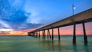
Pacifica is a city in San Mateo County, California, on the coast of the Pacific Ocean between San Francisco and Half Moon Bay.

<span class="mw-page-title-main">Portola Valley, California</span> City in California, United States

Portola Valley is a town in San Mateo County, California, United States. Located on the San Francisco Peninsula in the Bay Area, Portola Valley is a small, wealthy community nestled on the eastern slopes of the Santa Cruz Mountains.

<span class="mw-page-title-main">Redwood City, California</span> City in the United States

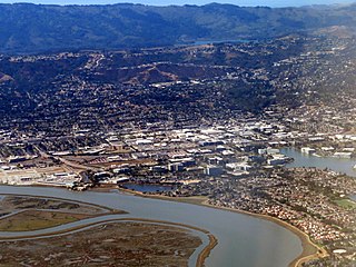
Redwood City is a city on the San Francisco Peninsula in Northern California's Bay Area, approximately 27 miles (43 km) south of San Francisco, and 24 miles (39 km) northwest of San Jose. Redwood City's history spans its earliest inhabitation by the Ohlone people to being a port for lumber and other goods. The county seat of San Mateo County in the heart of Silicon Valley, Redwood City is home to several global technology companies including Oracle, Electronic Arts, Evernote, Box, and Informatica. The city's population was 84,292 according to the 2020 census. The Port of Redwood City is the only deepwater port on San Francisco Bay south of San Francisco.

<span class="mw-page-title-main">San Bruno, California</span> City in California, United States

San Bruno is a city in San Mateo County, California, United States, incorporated in 1914. The population was 43,908 at the 2020 United States Census. The city is between South San Francisco and Millbrae, adjacent to San Francisco International Airport and Golden Gate National Cemetery; it is approximately 12 miles (19 km) south of Downtown San Francisco.

<span class="mw-page-title-main">San Mateo, California</span> City in California, United States

San Mateo is a city in San Mateo County, California, United States, on the San Francisco Peninsula. About 20 miles (32 km) south of San Francisco, the city borders Burlingame to the north, Hillsborough to the west, San Francisco Bay and Foster City to the east and Belmont to the south. The population was 105,661 at the 2020 census.

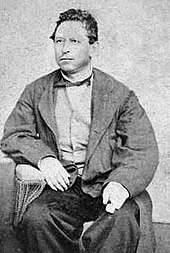
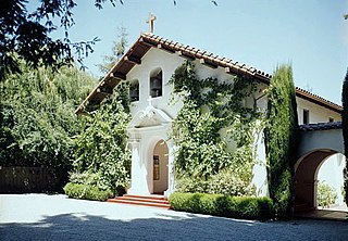
The Lamchin were one of many tribes of the Ohlone (Coastanoan) people, Native Americans who lived along the San Francisco Peninsula. The Lamchin were the native inhabitants of what is now San Carlos, California. Information is sparse and dispersed, coming mostly from Spanish mission records – as the natives had no written language. The collected information follows over 100 years of research by many noted historians. The Lamchin are believed to be extinct – as historical, statistical and limited written accounts would seem to indicate.

<span class="mw-page-title-main">Ramaytush</span> Linguistic subdivision of Ohlone people

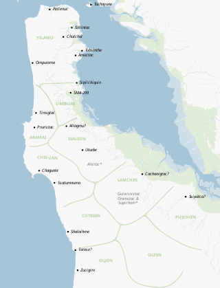
The Ramaytush or Rammay-tuš people are a linguistic subdivision of the Ohlone people of Northern California. The term Ramaytush was first applied to them in the 1970s, but the modern Ohlone people of the peninsula have claimed it as their ethnonym. The ancestors of the Ramaytush Ohlone people have lived on the peninsula—specifically in the area known as San Francisco and San Mateo county—for thousands of years. Prior to the California Genocide, the Ohlone people were not consciously united as a singular socio-political entity. In the early twentieth century anthropologists and linguists began to refer to the Ramaytush Ohlone as San FranciscoCostanoans—the people who spoke a common dialect or language within the Costanoan branch of the Utian family. Anthropologists and linguists similarly called the Tamyen people Santa Clara Costanoans, and the Awaswas people Santa Cruz Costanoans.

References

  1. "2010 Census U.S. Gazetteer Files – Places – California". United States Census Bureau.
  2. "California Cities by Incorporation Date". California Association of Local Agency Formation Commissions. Archived from the original (Word) on November 3, 2014. Retrieved August 25, 2014.
  3. "San Carlos History" (Webpage). City of San Carlos, CA. Retrieved September 9, 2022.
  4. 1 2 "City Manager". City of San Carlos. Archived from the original on February 7, 2015. Retrieved February 6, 2015.
  5. 1 2 "City Council". City of San Carlos. Retrieved January 20, 2019.
  6. "City Treasurer". City of San Carlos. Retrieved July 13, 2023.
  7. 1 2 3 "Statewide Database". UC Regents. Archived from the original on February 1, 2015. Retrieved December 16, 2014.
  8. "2019 U.S. Gazetteer Files". United States Census Bureau. Retrieved July 1, 2020.
  9. "San Carlos". Geographic Names Information System . United States Geological Survey, United States Department of the Interior.
  10. "San Carlos (city) QuickFacts". United States Census Bureau.
  11. Milliken, Randall. A Time of Little Choice: The Disintegration of Tribal Culture in the San Francisco Bay Area 1769-1810 Menlo Park, CA: Ballena Press Publication, 1995. ISBN   0-87919-132-5
  12. See Milliken, Table 8
  13. Lopez, Sierra (October 12, 2020). "San Carlos eatery will be a homage to city's history". Daily Journal Corporation.
  14. U.S. Army Quartermaster Museum, Fort Lee, Virginia "War Dogs". Archived from the original on January 20, 2013. Retrieved January 20, 2013.
  15. 1 2 3 Images of America – San Carlos by Nicholas A. Veronico & Betty S. Veronico, Arcadia Publishing
  16. Lemish, Michael G. War Dogs: A History of Loyalty and Heroism. Brassey’s Inc.
  17. Vainshtein, Annie; Umanzor, Joel (September 8, 2022). "Report: Woman beheaded on a San Carlos street in front of witnesses". San Francisco Chronicle. Retrieved March 8, 2023.
  18. Chrisholm, Johanna (September 9, 2022). "Woman beheaded by man with a sword on Bay Area street had restraining order". The Independent. Retrieved March 8, 2023.
  19. Noyes, Dan (September 9, 2022). "Young mother beheaded on street identified, new info on man held in attack". ABC7 Chicago. Retrieved March 8, 2023.
  20. "Average Climate for San Carlos California". The Weather Channel. January 2018. Retrieved January 13, 2018.
  21. "Census of Population and Housing". Census.gov. Retrieved June 4, 2015.
  22. "2020 Census Interactive Population Search: CA - San Carlos city". United States Census Bureau . Retrieved September 20, 2022.
  23. "2010 Census Interactive Population Search: CA - San Carlos city". U.S. Census Bureau. Archived from the original on July 15, 2014. Retrieved July 12, 2014.
  24. "Demographic Profile Bay Area Census".
  25. "U.S. Census website". United States Census Bureau . Retrieved January 31, 2008.
  26. American FactFinder. Factfinder.census.gov. Retrieved on July 21, 2013.
  27. "City of San Carlos ACFR" (PDF). cityofsancarlos.org.
  28. "L-3 Communications to Consolidate San Carlos Operations". May 17, 2016. Retrieved May 29, 2019.
  29. "CA Secretary of State – Report of Registration – February 10, 2019" (PDF). ca.gov. Retrieved March 12, 2019.
  30. "California's 15th Congressional District - Representatives & District Map". Civic Impulse, LLC. Retrieved March 12, 2013.
  31. Arundel
  32. Brittan Acres
  33. Heather
  34. White Oaks
  35. Arroyo
  36. Mariposa
  37. Central Middle School
  38. "Plans proceeding for two high schools: Traffic from one magnet a concern for some San Carlos neighbors, other planned for Menlo Park - - San Mateo Daily Journal". Archived from the original on December 15, 2014.
  39. St. Charles School
  40. Arbor Bay School
  41. Murphy, Dave (July 30, 2004). "SCOOT-ers' free ride is on the line". SFGATE. Retrieved June 18, 2021.
  42. "Profile: Kathryn Bigelow". March 8, 2010. Retrieved March 26, 2018 via news.bbc.co.uk.
  43. "Barry Bonds - Society for American Baseball Research". sabr.org. Retrieved March 26, 2018.
  44. "Barry Bonds' Childhood Home on Market". nbcbayarea.com. July 7, 2011. Retrieved March 26, 2018.
  45. Nicholas A. Veronico; Betty S. Veronico (2007). San Carlos. Arcadia Publishing. p. 92. ISBN   978-0-7385-4793-0 . Retrieved March 26, 2018.
  46. "AllPolitics - TIME This Week: Confession Of A Microsoft Converter - Mar. 17, 1997". edition.cnn.com. Retrieved March 26, 2018.
  47. "Dana Carvey's favorite role: fatherhood". sfgate.com. April 30, 2010. Retrieved March 26, 2018.
  48. Graff, Amy (March 25, 2021). "Bay Area-raised funnyman Dana Carvey nails Joe Biden impression". SFGATE. Retrieved March 26, 2021.
  49. "San Mateo County Historical Association". San Mateo County History Museum. Retrieved September 25, 2019.
  50. "Jim Davenport, former Giants third baseman, dies". mercurynews.com. February 19, 2016. Retrieved March 26, 2018.
  51. 1 2 "2014 Giants Media Guide - San Francisco Giants" (PDF). San Francisco Giants Media Guide. Retrieved September 25, 2019.
  52. "St. Louis Cardinals second baseman grew up an Oakland A's fan". mercurynews.com. October 13, 2012. Retrieved March 26, 2018.
  53. Goldstein, Amy (May 20, 2009). "Governor Granholm's Rise to Politics" . Retrieved March 26, 2018 via www.washingtonpost.com.
  54. Pollack, Andrew (May 3, 1987). "WHY THE SUN NEVER SETS ON A GEOCHRON CLOCK (Published 1987)". The New York Times. ISSN   0362-4331 . Retrieved January 5, 2021.
  55. "As the World Turns, So Does James Kilburg's Moving Wall Map, Keeping Track of Global Time". PEOPLE.com. Retrieved January 5, 2021.
  56. "San Carlos mayor relishes Oscar win for 'Ratatouille'". eastbaytimes.com. February 26, 2008. Retrieved March 26, 2018.
  57. "Phelps, Timothy Guy - San Carlos was nearly named Phelpsville". historysmc.pastperfectonline.com. Retrieved March 26, 2018.
  58. "PASSED/FAILED: Greg Proops". independent.co.uk. July 17, 1997. Retrieved March 26, 2018.
  59. Litsky, Frank (December 19, 2002). "Dick Stuart: Pirates' Slugger 'Dr. Strangeglove'". The Pittsburgh Post-Gazette. Retrieved July 16, 2018.
  60. United Press International (May 13, 1959). "Giants Learn Meaning of Too Little, Too Late". The Madera Tribune. Retrieved July 6, 2018.
  61. "Tom Tennant - Society for American Baseball Research". sabr.org. Retrieved March 26, 2018.
  62. "interview to mark ulriksen". web.tiscali.it. Retrieved September 25, 2019.
  63. Whiting, Melanie (February 18, 2016). "Rex J. Walheim (Colonel, U.S. Air Force, Ret.) NASA Astronaut". nasa.gov. Retrieved March 26, 2018.
  64. "Fremont mayor Bob Wasserman dead at 77". East Bay Times. December 29, 2011. Retrieved August 31, 2018.
  65. 1 2 3 4 5 "Our Sister Cities". San Carlos Sister City Association. January 28, 2013. Retrieved July 16, 2018.

Further reading