City of Orinda | |
---|---|
Coordinates: 37°52′58″N122°10′47″W / 37.88278°N 122.17972°W | |
Country | United States |
State | California |
County | Contra Costa |
Incorporated | July 1, 1985 [1] |
Government | |
• Mayor | Darlene Gee [2] |
• State Senator | Steve Glazer (D) [3] |
• State Assembly | Rebecca Bauer-Kahan (D) [4] |
• U. S. Congress | Mark DeSaulnier (D) [5] |
Area | |
• Total | 12.87 sq mi (33.33 km2) |
• Land | 12.85 sq mi (33.29 km2) |
• Water | 0.02 sq mi (0.04 km2) 0.12% |
Elevation | 495 ft (151 m) |
Population (2020) | |
• Total | 19,514 |
• Density | 1,500/sq mi (590/km2) |
Time zone | UTC−8 (PST) |
• Summer (DST) | UTC−7 (PDT) |
ZIP Code | 94563 |
Area code | 925 |
FIPS code | 06-54232 |
GNIS feature IDs | 1659313, 2411334 |
Website | www |
Orinda is a city in Contra Costa County, California, United States. The city's population as of the 2020 census is estimated at 19,514 residents. [7]
Orinda is located within four Mexican land grants: Rancho Laguna de los Palos Colorados, Rancho Acalanes, Rancho El Sobrante and Rancho Boca de la Cañada del Pinole. The area was originally rural, mainly known for ranching and summer cabins. The Moraga Adobe was built in 1841, and is the oldest building in the East Bay. In the late 19th century, the land was named by Alice Marsh Cameron, probably in honor of the poet Katherine Philips, who was also known as the "Matchless Orinda". [8]
In the 1880s, United States Surveyor General for California Theodore Wagner built an estate he named Orinda Park. [9] The Orinda Park post office opened in 1888. [9] The post office's name was changed to Orinda in 1895. [9] Orinda was also the site of Bryant Station, a stop on the failed California and Nevada Railroad around the turn of the 20th century. Later, the area around Bryant Station was known as Orinda Crossroads. [9]
Orinda's popularity as a year-round residence grew after the 1937 completion of the Caldecott Tunnel, which provided easier access to the west. Bisected by California State Route 24 and framed by its rolling oak-covered hills, the city of Orinda was incorporated on July 1, 1985. Its first mayor was Richard G. Heggie. The city is served by Orinda station on the Bay Area Rapid Transit (BART) Yellow Line and Route 6 of the County Connection.
According to the United States Census Bureau, the city has a total area of 12.7 sq mi (33 km2), of which 12.7 sq mi (33 km2) of it is land and 0.015 sq mi (0.039 km2) of it (0.12%) is water.
The area is characterized by a warm-summer Mediterranean climate (Köppen climate classification: Csb) with cool, rainy winters and warm, dry summers. Because Orinda is located in a hilly area, microclimates often dominate temperature differences in short distances. The Oakland Hills often block the cool foggy conditions that can be seen in Oakland and the inner Bay. In the summer, fog can spill over the Oakland hills, cooling off the area. Heatwaves from the inland areas can be felt much more in Orinda than in Oakland and the inner Bay during the summer. In the winter, Orinda often sees more precipitation than surrounding areas because of its higher elevation. Snowfall is rare but not unheard of. A dusting of snow may occur in any given year because of the elevation. During stable conditions in the winter, mornings can be cold and frosty in downtown and lower-lying areas, while the higher hills surrounding the area may be several degrees warmer.
Orinda, California | ||||||||||||||||||||||||||||||||||||||||||||||||||||||||||||
---|---|---|---|---|---|---|---|---|---|---|---|---|---|---|---|---|---|---|---|---|---|---|---|---|---|---|---|---|---|---|---|---|---|---|---|---|---|---|---|---|---|---|---|---|---|---|---|---|---|---|---|---|---|---|---|---|---|---|---|---|
Climate chart (explanation) | ||||||||||||||||||||||||||||||||||||||||||||||||||||||||||||
| ||||||||||||||||||||||||||||||||||||||||||||||||||||||||||||
|
Climate data for Orinda Bowman, California (1944–1960) | |||||||||||||
---|---|---|---|---|---|---|---|---|---|---|---|---|---|
Month | Jan | Feb | Mar | Apr | May | Jun | Jul | Aug | Sep | Oct | Nov | Dec | Year |
Record high °F (°C) | 69 (21) | 76 (24) | 84 (29) | 88 (31) | 100 (38) | 103 (39) | 107 (42) | 109 (43) | 110 (43) | 101 (38) | 87 (31) | 77 (25) | 110 (43) |
Mean daily maximum °F (°C) | 54 (12) | 59 (15) | 61 (16) | 68 (20) | 71 (22) | 77 (25) | 82 (28) | 81 (27) | 83 (28) | 75 (24) | 65 (18) | 56 (13) | 69 (21) |
Mean daily minimum °F (°C) | 34 (1) | 37 (3) | 38 (3) | 42 (6) | 46 (8) | 49 (9) | 52 (11) | 51 (11) | 50 (10) | 44 (7) | 38 (3) | 36 (2) | 43 (6) |
Record low °F (°C) | 15 (−9) | 18 (−8) | 23 (−5) | 28 (−2) | 32 (0) | 35 (2) | 42 (6) | 40 (4) | 32 (0) | 26 (−3) | 22 (−6) | 19 (−7) | 15 (−9) |
Average precipitation inches (mm) | 5.99 (152) | 4.86 (123) | 4.31 (109) | 2.16 (55) | 1.22 (31) | 0.18 (4.6) | 0.02 (0.51) | 0.05 (1.3) | 0.41 (10) | 1.85 (47) | 3.24 (82) | 6.24 (158) | 30.53 (773.41) |
Average rainy days | 11 | 9 | 10 | 5 | 4 | 1 | 0 | 1 | 1 | 4 | 7 | 11 | 64 |
Source: Western Regional Climate Center [10] [11] |
Census | Pop. | Note | %± |
---|---|---|---|
1960 | 5,568 | — | |
1970 | 6,790 | 21.9% | |
1980 | 16,825 | 147.8% | |
1990 | 16,642 | −1.1% | |
2000 | 17,599 | 5.8% | |
2010 | 17,643 | 0.3% | |
2020 | 19,514 | 10.6% | |
U.S. Decennial Census [12] |
The 2010 United States Census [13] reported that Orinda had a population of 17,643, The population density was 1,389.5 inhabitants per square mile (536.5/km2), The racial makeup of Orinda was 14,533 (82.4%) White-American, 149 (0.8%) African American, 22 (0.1%) Native American, 2,016 (11.4%) Asian-American, 24 (0.1%) Pacific Islander, 122 (0.7%) from other races, and 777 (4.4%) from two or more races. There were 807 people (4.6%) of Hispanic or Latino origin, of any race.
The Census reported that 17,600 people (99.8% of the population) lived in households, 6 (>0.1%) lived in non-institutionalized group quarters, and 37 (0.2%) were institutionalized.
There were 6,553 households, out of which 2,361 (36.0%) had children under the age of 18 living in them, 4,673 (71.3%) were opposite-sex married couples living together, 370 (5.6%) had a female householder with no husband present, 159 (2.4%) had a male householder with no wife present. There were 138 (2.1%) unmarried opposite-sex partnerships, and 58 (0.9%) same-sex married couples or partnerships, 1,127 households (17.2%) were made up of individuals, and 695 (10.6%) had someone living alone who was 65 years of age or older. The average household size was 2.69. There were 5,202 families (79.4% of all households); the average family size was 3.03.
The population was spread out, with 4,512 people (25.6%) under the age of 18, 729 people (4.1%) aged 18 to 24, 2,741 people (15.5%) aged 25 to 44, 6,111 people (34.6%) aged 45 to 64, and 3,550 people (20.1%) who were 65 years of age or older. The median age was 47.8 years. For every 100 females, there were 94.4 males. For every 100 females age 18 and over, there were 91.9 males.
There were 6,804 housing units, at an average density of 535.8 per square mile (206.9/km2), of which 6,553 were occupied, of which 5,876 (89.7%) were owner-occupied, and 677 (10.3%) were occupied by renters. The homeowner vacancy rate was 1.2%; the rental vacancy rate was 4.2%. 16,010 people (90.7% of the population) lived in owner-occupied housing units and 1,590 people (9.0%) lived in rental housing units.
As of February 10, 2019, Orinda has 14,020 registered voters, with 6,692 (47.7%) registered as Democrats, 3,176 (22.7%) registered as Republicans, and 3,662 (26.1%) decline to state voters. [14]
Orinda has four public elementary schools: Sleepy Hollow Elementary, Wagner Ranch Elementary, Glorietta Elementary and Del Rey Elementary. Orinda Intermediate School is the only middle school. Together, these five schools make up the Orinda Union School District. Orinda's high school, Miramonte High School, is a part of the Acalanes Union High School District.
Orinda is home to three private educational establishments: Orinda Academy, Holden High School, and Fountainhead Montessori School. Of these, two (OA & Holden) are private high schools, while Fountainhead Montessori School services kindergarten through fifth grade.
The Contra Costa County Library has a branch in Orinda.
Contra Costa County is a county located in the U.S. state of California, in the East Bay of the San Francisco Bay Area. As of the 2020 United States Census, the population was 1,165,927. The county seat is Martinez. It occupies the northern portion of the East Bay region of the San Francisco Bay Area and is primarily suburban. The county's name refers to its position on the other side of the bay from San Francisco. Contra Costa County is included in the San Francisco–Oakland–Berkeley, CA Metropolitan Statistical Area.
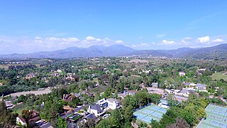
Alamo is an unincorporated community and census-designated place (CDP) in Contra Costa County, California, in the United States. It is a suburb located in the San Francisco Bay Area's East Bay region, approximately 28 miles (45 km) east of San Francisco. Alamo is equidistant from the city of Walnut Creek and the incorporated town of Danville. As of the 2020 census, the population was 15,314.
Lafayette is a city in Contra Costa County, California, United States. As of 2020, the city's population was 25,391. It was named after the Marquis de Lafayette, a French military officer of the American Revolutionary War.
Martinez is a city and the county seat of Contra Costa County, California, United States, in the East Bay region of the San Francisco Bay Area. Located on the southern shore of the Carquinez Strait, the city's population was 37,287 at the 2020 census. The city is named after Californio ranchero Ygnacio Martínez, having been founded on his Rancho El Pinole. Martinez is known for its historic center and its waterfront.
Moraga is a town in Contra Costa County, California, in the San Francisco Bay Area. The town is named in honor of Joaquín Moraga, member of the famed Californio family. As of 2020, Moraga had a total population of 16,870 people. Moraga is the home of Saint Mary's College of California.
Pittsburg is a city in Contra Costa County, California, United States. It is an industrial suburb located on the southern shore of the Suisun Bay in the East Bay region of the San Francisco Bay Area, and is part of the Sacramento–San Joaquin River Delta area, the Eastern Contra Costa County area, and the San Francisco Bay Area. The population was 76,416 at the 2020 United States Census.
San Ramon is a city in Contra Costa County, California, United States, located within the San Ramon Valley, and 34 miles (55 km) east of San Francisco. San Ramon's population was 84,605 per the 2020 census, making it the 4th largest city in Contra Costa County, behind Richmond, Concord and Antioch.
Walnut Creek is a city in Contra Costa County, California, United States, located in the East Bay region of the San Francisco Bay Area, about 16 miles east of the city of Oakland. Walnut Creek has a total population of 70,127 per the 2020 census, is located at the junction of the highways from Sacramento and San Jose (I-680) and San Francisco/Oakland (SR-24), and is accessible by BART. The city shares its borders with Clayton, Lafayette, Alamo, Pleasant Hill, and Concord.
Lomita is a city in Los Angeles County, California, United States. The population was 20,921 at the 2020 census, up slightly from 20,256 at the 2010 census.
Soledad is a city in Monterey County, California, United States. It is in the Salinas Valley, 21 miles (34 km) southeast of Salinas, the county seat. Soledad's population was 24,925 at the 2020 census, down from 25,738 in 2010. Soledad's origins started with Mission Nuestra Señora de la Soledad, founded by the Spanish in 1791, under the leadership of Fermín de Lasuén. Catalina Munrás began developing the town of Soledad on her Rancho San Vicente in the 1860s, which eventually incorporated as a city in 1921. Today, Soledad is a notable tourist destination, owing to the heavily restored mission, its proximity to Pinnacles National Park, and its numerous vineyards, as part of the Monterey wine region.
Coto de Caza is a census-designated place (CDP) and guard-gated private community in Orange County, California, United States. The population was 14,710 at the 2020 census.
Los Alamitos is a city in Orange County, California. The city was incorporated in March 1960. The population was 11,780 at the 2020 census, up from 11,449 at the 2010 census. The adjacent unincorporated community of Rossmoor uses the same 90720 ZIP code in its mailing address, but is not part of the city. The Los Alamitos Race Course is named for the city, but lies in the neighboring city of Cypress.
Rancho Santa Margarita is a city in Orange County, California, United States. One of Orange County's youngest cities, Rancho Santa Margarita is a master-planned community. The population was 47,853 at the 2010 census, up from 47,214 at the 2000 census. Although it is named for Rancho Santa Margarita y Las Flores, which was in San Diego County, the city limits fall within the borders of Rancho Mission Viejo. At 20 characters long, it is the longest city name in California.
Murrieta is a city in southwestern Riverside County, California, United States. The population of Murrieta was 110,949 as of the 2020 census. Murrieta experienced a 133.7% population increase between 2000 and 2010, making Murrieta one of the fastest-growing cities in the state during that period. Largely residential in character, Murrieta is typically characterized as a bedroom community. Murrieta is bordered by the city of Temecula to the south, the cities of Menifee and Wildomar to the north, and the unincorporated community of French Valley to the east. Murrieta is located in the center of the Los Angeles-San Diego mega-region. Murrieta is named for Juan Murrieta, a Californio ranchero who founded the town.
Chino is a city in the western end of San Bernardino County, California, United States, with Los Angeles County to its west and Orange County to its south in the Southern California region.
Half Moon Bay is a coastal city in San Mateo County, California, United States, approximately 25 miles south of San Francisco. Its population was 11,795 as of the 2020 census. Immediately north of Half Moon Bay is Pillar Point Harbor and the unincorporated community of Princeton-by-the-Sea. Half Moon Bay is known for Mavericks, a big-wave surf location. It is called Half Moon Bay because of its crescent shape.
Miramonte High School is a four-year public high school located in Orinda, California, United States. It is part of the Acalanes Union High School District. The school has a college-preparatory program, with 15 Advanced Placement courses offered.
Acalanes Union High School District is a public high school district in Contra Costa County, located in the Bay Area of California. The district takes its name from Rancho Acalanes, an 1834 Mexican rancho grant which occupied much of the area from Orinda to Lafayette. The district operates four high schools.
Orinda Union School District (OUSD) is a school district in Orinda, California, United States, that serves students in Transitional Kindergarten (TK) through 8th grade. It consists of four elementary schools and one middle school. It is the highest ranked TK–8 school district in California, ranked by API score. Orinda Union School District’s Del Rey Elementary, Glorietta Elementary, and Wagner Ranch Elementary were also selected as California Distinguished Schools for 2018. On completion of middle school, students generally enroll in nearby Acalanes Union High School District, usually to either Miramonte High School (Orinda) or Campolindo High School (Moraga).
Acalanes Ridge is a census-designated place in Contra Costa County, California. Acalanes Ridge sits at an elevation of 499 feet (152 m). The population was 1,285 at the 2020 Census.