Central California

Last updated

Central California
Pumpjacks, San Joaquin Valley, California.jpg
San Joaquin Valley, California
CentralCA.png
Map of counties that overlap Central California
Country United States
State California
RegionCentral California
Highest elevation
14,505 ft (4,421 m)
Lowest elevation
−13 ft (−4 m)
Time zone Pacific Standard Time
  Summer (DST) Pacific Daylight Time
Area code(s) 209, 559, 661, 805, 831

Central California is generally thought of as the middle third of the U.S. state of California, north of Southern California (which includes Los Angeles and San Diego) and south of Northern California (which includes San Francisco and San Jose). It includes the northern portion of the San Joaquin Valley (which itself is the southern portion of the Central Valley, beginning at the Sacramento–San Joaquin River Delta), part of the Central Coast, the central hills of the California Coast Ranges and the foothills and mountain areas of the central Sierra Nevada.

Contents

Central California is considered to be west of the crest of the Sierra Nevada. East of the Sierra is Eastern California. The largest cities in the region (over 50,000 population), from most to least populous, are Fresno, Bakersfield, Stockton, Modesto, Salinas, Visalia, Clovis, Santa Maria, Merced, Turlock, Madera, Lodi, Tulare, Porterville, Hanford and Delano. Over time, droughts and wildfires have increased in frequency and become less seasonal and more year-round, further straining the region's water security. [1] [2] [3]

Geography

Central California can have widely varying definitions depending on the context. Some divide the state by lines of latitude making northern, central and southern sections. Others divide by county lines or watershed boundaries. Some definitions include more of the San Joaquin Valley and even larger portions of the Central Valley. Some have less or none of Central Coast.

Merced River from Yosemite Yosemite.JPG
Merced River from Yosemite
Big Sur Big Sur June 2008.jpg
Big Sur

Counties

The rough definition of Central California includes some or all of the following 15 counties:

Cities

Area cities and towns listed below are major regional centers or county seats.

Salinas Valley Greenfield California.JPG
Salinas Valley

Sub-regions

The following regions are entirely contained within central California:

The following regions are partially contained within central California:

Education

Central California has opened two new universities recently, one in each of the past two decades.

The University of California has one campus in the region. University of California, Merced opened on a newly constructed site on the east side of Merced in 2005.

The California State University system has four campuses in the region. California State University, Monterey Bay opened on the site of the former Fort Ord army base in 1994. California State University, Stanislaus in Turlock opened in 1957. California State University, Fresno opened in 1911.

The Monterey Institute of International Studies is a graduate school that offers eleven master's degree programs in international policy, international management, language teaching, and translation and interpretation. The Monterey Institute of International Studies is a graduate school of Middlebury College.

San Joaquin College of Law is a private, nonprofit law school located in Clovis.

Fresno Pacific University is a private university in Fresno.

The Naval Postgraduate School and Defense Language Institute are located in Monterey.

The following community college campus sites are in the region: [4]

There are no community colleges in Mariposa or San Benito Counties.

Transport

Major highways

Most of the major highways in the region run north-south around the mountains. Interstate 5 and State Route 99 are the primary highways in the San Joaquin Valley. US 101 and State Route 1 are the major coastal highways.

Rail

Passenger rail in the region consists of the Amtrak long-haul Coast Starlight and the regional San Joaquins routes.

The California High-Speed Rail system is under construction between Merced and Bakersfield. In Central California, the system will have stations in Merced, Madera, Fresno, and the Kings–Tulare area. Planning is underway to extend the initial line to San Francisco/San Jose and Los Angeles.

Freight rail is served by commercial railroads. Union Pacific Railroad and BNSF Railway operate mainline freight through the region in the Central Valley.

Air

Major and regional airline services are available at Fresno Yosemite International Airport and Monterey Regional Airport. Regional airline service is also available at Merced Regional Airport.

General Aviation airports exist in all ten counties. The largest are former military bases converted to civilian airports

An active military air base is at Naval Air Station Lemoore in Kings County, and the 144th Fighter Wing is stationed at Fresno Air National Guard Base in Fresno County.

Notes

Variations on significant/influential definitions of the term central California are collected in this section.

The following counties are self-described as being in central California or central within California:

The following are definitions by influential organizations:

Related Research Articles

<span class="mw-page-title-main">Northern California</span> American geographic and cultural region

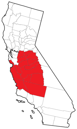
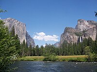
Northern California is a geographic and cultural region that generally comprises the northern portion of the U.S. state of California, spanning the northernmost 48 of the state's 58 counties. Its main population centers include the San Francisco Bay Area, the Greater Sacramento area, the Redding, California, area south of the Cascade Range, and the Metropolitan Fresno area. Northern California also contains redwood forests, along with most of the Sierra Nevada, including Yosemite Valley and part of Lake Tahoe, Mount Shasta, and most of the Central Valley, one of the world's most productive agricultural regions.

<span class="mw-page-title-main">San Joaquin Valley</span> Area of the Central Valley in California

The San Joaquin Valley is the southern half of California's Central Valley. Famed as a major breadbasket, the San Joaquin Valley is an important source of food, producing a significant part of California's agricultural output.

<span class="mw-page-title-main">Roman Catholic Diocese of Fresno</span> Diocese of the Catholic Church in central California

The Diocese of Fresno (Latin: Dioecesis Fresnensis is a diocese of the Latin Church in the Central Valley of California in the United States. It is a suffragan diocese of the Archdiocese of Los Angeles.

<span class="mw-page-title-main">Area code 559</span> Telephone code in California

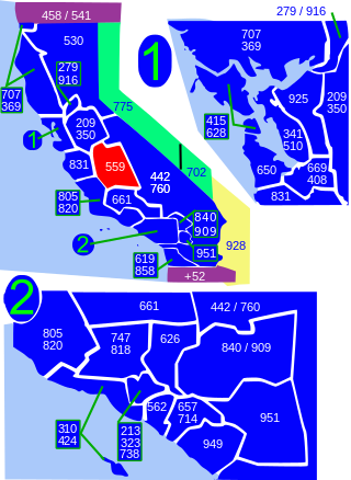
Area code 559 is a telephone area code in the North American Numbering Plan for the central San Joaquin Valley in central California. The numbering plan area includes the counties of Fresno, Madera, Kings, and Tulare, an area largely coextensive with the Fresno and Visalia-Porterville metropolitan areas. The area code was placed in service in 1998, when its services area was split from that of area code 209.

<span class="mw-page-title-main">San Joaquin Valley Railroad</span> Central California freight transport company

The San Joaquin Valley Railroad is one of several short line railroad companies and is part of the Western Region Division of Genesee & Wyoming Inc. It operates over about 371 miles (597 km) of owned or leased track primarily on several lines in California's Central Valley/San Joaquin Valley around Fresno and Bakersfield. The SJVR has trackage rights over Union Pacific between Fresno, Goshen, Famoso, Bakersfield and Algoso. The SJVR also operated for the Tulare Valley Railroad (TVRR) from Calwa to Corcoran and Famoso.

California's 20th congressional district is a congressional district in California including much of the southern and southeastern part of the state's Central Valley. The district currently has no representative in the United States House of Representatives due to the resignation of Kevin McCarthy following the motion to vacate that ousted him from the office of House Speaker.

The San Joaquin Valley League was a minor league baseball league that operated from 1910 through 1911. The league operated primarily in the San Joaquin Valley in California. The league disbanded on July 18, 1911. The Bakersfield Drillers and Tulare Merchants won league championships.

<span class="mw-page-title-main">California Community College Athletic Association</span> Collegiate athletics organization in California, US

The California Community College Athletic Association (CCCAA) is a sports association of community colleges in the U.S. state of California. It oversees 108 athletic programs throughout the state. The organization was formed in 1929 as the California Junior College Federation to unify programs in Northern and Southern California.

There are 45 routes assigned to the "J" zone of the California Route Marker Program, which designates county routes in California. The "J" zone includes county highways in Alameda, Calaveras, Contra Costa, Fresno, Kern, Inyo, Mariposa, Merced, Sacramento, San Benito, San Joaquin, Stanislaus, and Tulare counties.

The Stockton–Los Angeles Road, also known as the Millerton Road, Stockton–Mariposa Road, Stockton–Fort Miller Road or the Stockton–Visalia Road, was established about 1853 following the discovery of gold on the Kern River in Old Tulare County. This route between Stockton and Los Angeles followed by the Stockton–Los Angeles Road is described in "Itinerary XXI. From Fort Yuma to Benicia, California", in The Prairie Traveler: A Hand-book for Overland Expeditions by Randolph Barnes Marcy. The Itinerary was derived from the report of Lieutenant R. S. Williamson on his topographical survey party in 1853, that was in search of a railroad route through the interior of California.

<span class="mw-page-title-main">California Digital Newspaper Collection</span> Online archive of digitized newspapers

The California Digital Newspaper Collection (CDNC) is a freely-available, archive of digitized California newspapers; it is accessible through the project's website. The collection contains over six million pages from over forty-two million articles. The project is part of the Center for Bibliographical Studies and Research (CBSR) at the University of California Riverside.

<span class="mw-page-title-main">Clement Renzi</span> American sculptor (1925–2009)

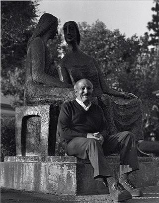
Clement Renzi was an American sculptor whose figurative bronze and terra cotta works depict people, human relationships, animals, and birds. His work has been popular with collectors in California's Central Valley and is placed in more than 60 public venues, primarily in that region.

The Tulare Merchants were a minor league baseball team based in Tulare, California. In 1910 and 1911, the Merchants played exclusively as members of the Class D level San Joaquin Valley League, winning the 1911 league championship in their final season of play.

The Cross Valley Corridor is a proposed passenger rail service in the California Central Valley, connecting Visalia, Hanford, Porterville, and surrounding cities to each other and California High-Speed Rail's planned Kings–Tulare Regional Station.

References

General
  1. "Drought.gov" . Retrieved November 20, 2021.[ title missing ]
  2. Boxall, Bettina; St. John, Paige (November 10, 2018). "California's most destructive wildfire should not have come as a surprise". Los Angeles Times . Retrieved November 11, 2018.
  3. "Advancing Drought Science and Preparedness across the Nation". National Integrated Drought Information System. Archived from the original on November 11, 2018. Retrieved November 11, 2018.
  4. "College Listings". California Community Colleges Chancellor's Office. Archived from the original on January 21, 2010. Retrieved January 23, 2010.
  5. "Oakhurst Community College Center". Oakhurst Community College Center. Retrieved December 8, 2020.
  6. "About the County". Fresno County, California. Archived from the original on July 18, 2011. Retrieved January 24, 2010.
  7. "Madera County Statistical Information". Madera County, California. Archived from the original on January 16, 2010. Retrieved January 24, 2010.
  8. "Madera County Economic Development Commission". Madera County Economic Development Commission. Retrieved January 24, 2010.
  9. "About Tulare County". Tulare County, California. Archived from the original on January 10, 2010. Retrieved January 24, 2010.
  10. "Map of California". National Register of Historic Places . Retrieved January 24, 2010.
  11. "Highway Information Area Maps". California Department of Transportation . Retrieved January 24, 2010.
  12. "Contact Us". Central California Better Business Bureau . Retrieved January 24, 2010.
Specific

37°N120°W / 37°N 120°W / 37; -120