Salinas Valley

Last updated
Salinas Valley
Valle de Salinas (Spanish)
Greenfield California.JPG
Salinas Valley, on River Road near Greenfield.
Length90 miles (145 km)northwest to southeast
Geography
Location California, United States
Population centers Castroville, Salinas, King City, San Ardo
Traversed by U.S. Route 101
Rivers Salinas River

The Salinas Valley (Spanish: Valle de Salinas) [1] [2] is one of the major valleys and most productive agricultural regions in California. [3] It is located west of the San Joaquin Valley and south of San Francisco Bay and the Santa Clara Valley.

Contents

The Salinas River, which geologically formed the fluvial valley and generated its human history, flows to the northwest or 'up' along the principal axis and the length of the valley.

The valley was named during the late 18th-century Spanish colonial Alta California period, and in Spanish Salina is the term for a salt marsh, salt lake, or salt pan. The seasonal Salinas River had brackish tule ponds in broad depressed areas, and more salinity during summer and when drought lowered flows.

The valley runs in a southeast to northwest alignment. It begins south of San Ardo, framed by the central inner California Coast Ranges, continues northwestward continuously defined on the west by the Santa Lucia Range, on the east by the Gabilan Range, to its end and the river's mouth at the Monterey Bay.

It is also known for being the setting of the novels East of Eden and Of Mice and Men , by John Steinbeck.

Geography

Map of the Salinas River watershed. Salinas River watershed.png
Map of the Salinas River watershed.

The Salinas Valley runs approximately 90 miles (145 km) southeast from the Salinas River mouth near Castroville and Salinas towards King City and San Ardo. The valley lends its name to the geologic province in which it is located, the Salinian Block. Cities and populated places in the Salinas Valley include Bradley, Castroville, Chualar, Gonzales, Greenfield, Jolon, King City, Salinas, San Ardo, San Lucas, Soledad and Spreckels. The Salinas Valley is located in between the Gabilan and Santa Lucia mountain ranges, which border the Salinas Valley to the east and the west, respectively.[ citation needed ]

History

Before colonization, the valley was inhabited by indigenous Salinans who lived by hunting and gathering and spoke the Salinan language. The Salinan people are believed to have lived south of Junipero Serra Peak, perhaps ranging from Slates Hot Springs on the coast to Soledad in the Salinas Valley and into northern San Luis Obispo County. [4] [5]

The Spanish colonial missions of San Miguel Arcángel, San Antonio de Padua and Nuestra Señora de la Soledad were all founded within the Salinas Valley in the late 18th century; from the last grew the city of Soledad.[ citation needed ]

The Franciscans baptized and forced the native population to labor at the missions. [6] Required to live in concentrated conditions, the aboriginal population was exposed to diseases unknown to them, including smallpox and measles. The Native American had no immunity and their population and culture were devastated. Many of the remaining people assimilated with Spanish and Mexican ranchers in the nineteenth century. [7] :264–267

An NYA photo illustrating young farm workers and the mechanization of agriculture. Monterey County, California. Rural youth. Mechanization, the agricultural employee. At the wheel of a farm-all tractor - NARA - 532242.tif
An NYA photo illustrating young farm workers and the mechanization of agriculture.

The commercial farming sector of the Dust Bowl era forms the backdrop for several John Steinbeck stories including East of Eden , Tortilla Flat , Of Mice and Men , The Chrysanthemums , and Johnny Bear [ citation needed ].

At a railroad crossing about one mile south of Chualar, a bus carrying Mexican migrant workers collided with a train in September 1963, killing 32 passengers and injuring 25. It was the most serious road accident in U.S. history, and helped spur abolition of the bracero program.[ citation needed ]

Agriculture

Agriculture dominates the economy of the valley. Promoters call the Salinas Valley "the Salad Bowl of the World" for the production of lettuce, broccoli, peppers and numerous other crops. The climate and long growing season are also ideal for the flower industry and grape vineyards planted by world-famous vintners.[ citation needed ]

In particular, a large majority[ citation needed ] of the salad greens consumed in the U.S. are grown within this region. Strawberries, lettuce, tomatoes, and spinach are the dominant crops in the valley. Other crops include broccoli, cauliflower, wine grapes, artichokes, and celery. Due to the intensity of local agriculture, the area has earned itself the nickname "America's Salad Bowl." The flower industry, grown in greenhouses, is now dominated by Matsui Nursery, which has been a major philanthropic benefactor to Salinas.

Salinas Valley is also an important viticultural area. Three American Viticultural Association "American Viticultural Area" domains are located within Salinas Valley: the Arroyo Seco AVA, the Santa Lucia Highlands AVA, and the Monterey AVA. [8] [9]

Although agriculture forms an economic base, more than 100 manufacturing firms call Salinas home. Some of the largest employers in the area include: Dole Fresh Vegetable, the County of Monterey, and Salinas Valley Memorial Hospital.

Water

An agricultural irrigation system near Chualar in the Salinas Valley. Irrigation system.JPG
An agricultural irrigation system near Chualar in the Salinas Valley.

Supplying Salinas Valley farms is an underground water supply fed, in part, by the large watershed in surrounding mountains. Two reservoirs – Nacimiento and San Antonio—store and release the water for groundwater recharge, flood control and farming. Wells access the groundwater to irrigate about 275,000 acres (1,110 km2) of fruits and vegetables and to supply the valley cities. The Salinas River itself is a sand river, so water appears on the surface only during heavy rains or when water is released from the upstream reservoirs.[ citation needed ]

Increasing demand for water near the mouth of the valley is drawing seawater into the freshwater aquifer. The Salinas Valley Water Project, now[ when? ] under construction by the Monterey County Water Resources Agency, will use an inflatable dam near Salinas to capture more water during wet periods. Monterey County Water Recycling Projects, a combination of the Castroville Seawater Intrusion Project and the Salinas Valley Reclamation Project, started delivering recycled water to fields near Castroville in 1998. The project's goal is to reduce pumping of groundwater and slow down seawater intrusion.[ citation needed ]

Climate

The Salinas Valley's weather varies from north to south. Proximity to Monterey Bay and the cool coastal waters of the Pacific cools the northern part of the valley in summer, and keeps it relatively mild in winter. The southern portion of the valley has greater extremes of temperature, hotter in summer, and colder in winter.[ citation needed ]

In summer, inland heating creates a thermal low that draws the marine layer into the valley, with fog and low clouds near Monterey Bay, sometimes extending farther down the valley.[ citation needed ]

The climate is ideal for the numerous vineyards in the Santa Lucia Highlands, promoting growth of winetasting along the River Road Wine Trail.[ citation needed ]

Local events

The California Rodeo Salinas, California International Airshow, [10] the National Steinbeck Center, and the Steinbeck Festival are major attractions in Salinas.

2007 Salmonella outbreak

On August 30, 2007, 8,000 cartons of spinach (from Metz Fresh, a King City-based grower and shipper, Salinas Valley, California) were recalled after Salmonella was discovered on routine testing. The incident led to a call from some consumer advocates and lawmakers for greater oversight in food safety, even if 90% of the suspect vegetable did not reach the shelves. [11]

Related Research Articles

<span class="mw-page-title-main">Monterey County, California</span> County in California, United States

Monterey County, officially the County of Monterey, is a county located on the Pacific coast in the U.S. state of California. As of the 2020 census, its population was 439,035. The county's largest city and county seat is Salinas.

<span class="mw-page-title-main">Castroville, California</span> Unincorporated community in California, United States

Castroville is an unincorporated town and census-designated place (CDP) in Monterey County, California, United States. At the time of the 2020 census the population was 7,515, up from 6,481 in 2010. Castroville is known for its artichoke crop and for the annual Castroville Artichoke Festival, leading to its nickname as the "Artichoke Center of the World".

<span class="mw-page-title-main">Greenfield, California</span> City in California, United States

Greenfield is a city in Monterey County, California, United States. Formerly Clarke Colony, it lies in the Salinas Valley, 33 miles (53 km) southeast of Salinas, at an elevation of 289 feet (88 m). As of the 2020 census, the population was 18,937, up from 16,330 in the 2010 census. Its most well-known public event is the annual Harvest Festival. Greenfield is a member of the Association of Monterey Bay Area Governments.

<span class="mw-page-title-main">Salinas, California</span> City in California, United States

Salinas is a city in the U.S. state of California and the county seat of Monterey County. With a population of 163,542 in the 2020 Census, Salinas is the most populous city in Monterey County. Salinas is an urban area located along the eastern limits of the Monterey Bay Area, lying just south of the San Francisco Bay Area and 10 miles (16 km) southeast of the mouth of the Salinas River. The city is located at the mouth of the Salinas Valley, about eight miles (13 km) from the Pacific Ocean, and it has a climate more influenced by the ocean than the interior.

<span class="mw-page-title-main">Soledad, California</span> City in California, United States

Soledad is a city in Monterey County, California, United States. It is in the Salinas Valley, 21 miles (34 km) southeast of Salinas, the county seat. Soledad's population was 24,925 at the 2020 census, down from 25,738 in 2010. Soledad's origins started with Mission Nuestra Señora de la Soledad, founded by the Spanish in 1791, under the leadership of Fermín de Lasuén. Catalina Munrás began developing the town of Soledad on her Rancho San Vicente in the 1860s, which eventually incorporated as a city in 1921. Today, Soledad is a notable tourist destination, owing to the heavily restored mission, its proximity to Pinnacles National Park, and its numerous vineyards, as part of the Monterey wine region.

<span class="mw-page-title-main">Salinas River (California)</span> River in California, United States

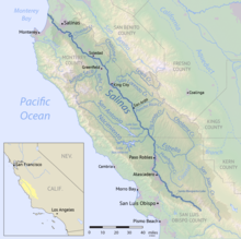
The Salinas River is the longest river of the Central Coast region of California, running 175 miles (282 km) and draining 4,160 square miles (10,800 km2). It flows north-northwest and drains the Salinas Valley that slices through the central California Coast Ranges south of Monterey Bay. The river begins in southern San Luis Obispo County, originating in the Los Machos Hills of the Los Padres National Forest. From there, the river flows north into Monterey County, eventually making its way to connect with the Monterey Bay, part of the Pacific Ocean, approximately 5 miles (8.0 km) south of Moss Landing. The river is a wildlife corridor, and provides the principal source of water from its reservoirs and tributaries for the farms and vineyards of the valley.

<span class="mw-page-title-main">Salinan</span> Native people and language of Monterey County, California

The Salinan are a Native American tribe whose ancestral territory is in the southern Salinas Valley and the Santa Lucia Range in the Central Coast of California. Today, the Salinan governments are now working toward federal tribal recognition from the Bureau of Indian Affairs.

<span class="mw-page-title-main">Carmel Valley AVA</span> American Viticultural Area in California

Carmel Valley is an American Viticultural Area (AVA) located in Monterey County, California, southeast of Carmel-by-the-Sea and it is one of the ten AVAs in the county. Approximately 100 miles (161 km) south of San Francisco, the AVA was recognized by the Bureau of Alcohol, Tobacco and Firearms (ATF), Treasury on January 13, 1983 after reviewing the petition submitted by Mr. David Armanasco, General Manager of Dumey Vineyard, located in Carmel, to propose a viticultural area named “Carmel Valley.”

<span class="mw-page-title-main">Area code 831</span> Area code for Monterey, Salinas and Santa Cruz, California

Area code 831 is a telephone area code in the North American Numbering Plan for a small region of the U.S. state of California. The numbering plan area (NPA) comprises Monterey County, San Benito County, and Santa Cruz County. The area code was created in 1998 in an area code split of area code 408.

<span class="mw-page-title-main">Gabilan Range</span> Mountain range in the American state of California

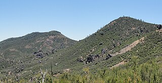
The Gabilan Range or Gabilán Range are a mountain range in the inner California Coast Ranges System, located in Monterey County and San Benito County of central California. Pinnacles National Park is located in the southern section of the range.

<span class="mw-page-title-main">Chalone AVA</span> Appelation that designates wine in Monterey County, CA

Chalone identifies the first American Viticultural Area (AVA) established in Monterey County, California straddling its border with San Benito County where it is the second established AVA. Chalone viticultural area is located in the Gabilan Mountains east of Soledad. It was recognized by the Bureau of Alcohol, Tobacco and Firearms (ATF) effective on July 14, 1982 after reviewing the petition submitted by the Gavilan Vineyards, Inc. to establish a viticultural area in Monterey and San Benito counties to be named "The Pinnacles." The area encompasses 8,640 acres (14 sq mi) and the proposed name was recognition of the nearby Chalone peaks.

<span class="mw-page-title-main">Nacimiento River</span> River in the United States of America

The Nacimiento River is a 64.8-mile-long (104.3 km) river in southern Monterey County and northern San Luis Obispo County, California. A large portion of the river's run is on military reservations. The river's upper reaches are inside Fort Hunter Liggett, Lake Nacimiento is in the middle and the lower reaches are inside Camp Roberts. It is the largest tributary of the Salinas River in terms of streamflow.

The San Antonio Valley AVA is an American Viticultural Area centered on San Antonio Valley, California in southern Monterey County, California. The AVA was approved in July 2006 by the United States Department of the Treasury Alcohol and Tobacco Tax and Trade Bureau.

The San Lucas AVA is an American Viticultural Area located in Monterey County, California. It is located at the southern end of Salinas Valley, shares an eastern border with the Chalone AVA, and is bordered on the west by the Santa Lucia Range foothills. The appellation has the largest diurnal temperature variation of any of California's AVAs.

The Hames Valley AVA is an American Viticultural Area located in Monterey County, California at about 35°52'N 120°52'W, about 2 km west of US Route 101. It became an AVA in 1994. It is part of the larger Monterey AVA, and is located at the southern end of the Salinas Valley in the foothills of the Santa Lucia Range. The soil in the valley is shale and loam, and the climate is slightly warmer than other regions of Monterey. In addition to Bordeaux varietals, traditional Port grapes such as Tinta Cao and Touriga Nacional are grown in the valley. One recent significant wine is the 2008 Nybakken "IV Amici" Petite Syrah.

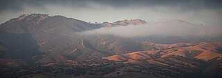
The Santa Lucia Highlands AVA is an American Viticultural Area located in Monterey County, California. It is part of the larger Monterey AVA, and located in the Santa Lucia Mountains above the Salinas Valley. Over 2,300 acres (931 ha) of vineyards are planted in the AVA, some as high as 1,200 feet (366 m) above sea level, with about half of them planted to the Pinot noir grape. The region enjoys cool morning fog and breezes from Monterey Bay followed by warm afternoons thanks to direct southern exposures to the sun.

<span class="mw-page-title-main">Pisoni Vineyards and Winery</span> Vineyard and winery located in California

Pisoni Estate is a family-owned and operated vineyard and winery located in the Santa Lucia Highlands of California’s Monterey Coast. It was founded in 1982 by Gary Pisoni, who was more interested in growing wine grapes than row crops for the family vegetable farm. He decided to plant a vineyard in the mountains above the Salinas Valley--an area previously considered undesirable for growing because of its dry, granitic soil. The vineyard began with small crops of Chardonnay, Cabernet Sauvignon, and Pinot Noir, then eventually focused on the Pinot Noir for which it has become renowned.

The River Road Wine Trail is a Salinas Valley wine-tasting route following River Road along the western banks of the Salinas River. It is not to be misidentified with the Great River Road that traverses along the banks of the Mississippi River through multiple states. The road also designates the eastern boundary of the Santa Lucia Highlands AVA and accesses many of the resident wineries contributing to local enotourism business. Due to its popularity, it is notably referenced in numerous books and magazines.

<span class="mw-page-title-main">Monterey County wine</span> Appelation that designates wine in Monterey County, CA

Monterey County wine is a appellation that designates wine made from grapes grown in Monterey County, California which lies entirely within the expansive multi-county Central Coast viticultural area. County names in the United States automatically qualify as legal appellations of origin for wine produced from grapes grown in that county and do not require registration with the Alcohol and Tobacco Tax and Trade Bureau (TTB). TTB was created in January 2003, when the Bureau of Alcohol, Tobacco and Firearms, or ATF, was extensively reorganized under the provisions of the Homeland Security Act of 2002.

<span class="mw-page-title-main">Gabilan Mountains AVA</span> Appelation that designates wine in Monterey County, CA

Gabilan Mountains is an American Viticultural Area (AVA) located in the mountainous region on the border in Monterey and San Benito Counties in California. It is the tenth and newest AVA established in Monterey County by the Alcohol and Tobacco Tax and Trade Bureau (TTB) on September 14, 2022, becoming the state's 147th official AVA after the TTB reviewed the petition from Parker Allen of Coastview Vineyards, proposing to establish the "Gabilan Mountains" viticultural area. Gabilan Mountains encompasses about 98,000 acres (153 sq mi) including the established Mt. Harlan and Chalone AVAs, and resident to 4 wineries and 6 commercial vineyards cultivating approximately 436 acres (176 ha). The average elevation within the region is 2,370 feet (722 m) placing it above the heavy fog and marine layer. As a result, Gabilan Mountains AVA has a cool air climate without the humidity from the fog and low-lying clouds.

References

  1. Kion546 - Dueños de negocios se alegran el poder volver a la feria del Valle de Salinas
  2. Clinica de Salud del Valle de Salinas
  3. McKibben, Carol Lynn (2022). Salinas : a history of race and resilience in an agricultural city. Stanford, California. ISBN   978-1-5036-2945-5. OCLC   1236850398.{{cite book}}: CS1 maint: location missing publisher (link)
  4. Jewell, Jennifer (October 12, 2018). "Obi Kaufmann & The California Field Atlas; Botanical Artistry Of October, Part 2". Cultivating Place (Podcast). North State Public Radio . Retrieved February 13, 2019 via SoundCloud.
  5. Kaufmann, Obi (2017a). The California Field Atlas. Heyday Books. ISBN   978-1-59714-402-5.
  6. "History of San Antonio de Padua Mission". 13 July 2011. Archived from the original on 2022-09-28. Retrieved 2023-06-12.
  7. Henson, Paul; Donald J. Usner (1993). "The Natural History of Big Sur" (PDF). University Of California Press. Archived from the original (PDF) on June 17, 2010. Retrieved 12 August 2016.
  8. Monterey County Vintners and Growers Association: Monterey California Appellations Archived 2008-10-09 at the Wayback Machine
  9. Monterey County Convention and Visitors Bureau: Wineries in the Salinas Valley
  10. California International Airshow Salinas. Salinasairshow.com (2013-01-22). Retrieved on 2014-07-21.
  11. NBC News, Spinach recall divides growers, lawmakers