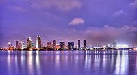
San Diego is a city on the Pacific Ocean coast in Southern California located immediately adjacent to the Mexico–United States border. With a population of over 1.3 million residents, the city is the eighth-most populous in the United States and the second-most populous in the state of California after Los Angeles. The city is the seat of San Diego County, which has a population of nearly 3.3 million people as of 2021. San Diego is known for its mild year-round Mediterranean climate, extensive beaches and parks, its long association with the United States Navy, and its recent emergence as a healthcare and biotechnology development center.

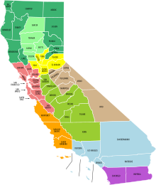
Southern California is a geographic and cultural region that generally comprises the southern portion of the U.S. state of California. It includes the Los Angeles metropolitan area as well as the Inland Empire. The region generally contains ten of California's 58 counties: Imperial, Kern, Los Angeles, Orange, Riverside, San Bernardino, San Diego, Santa Barbara, San Luis Obispo and Ventura counties.

A metropolitan area or metro is a region consisting of a densely populated urban agglomeration and its surrounding territories sharing industries, commercial areas, transport network, infrastructures and housing. A metropolitan area usually comprises multiple principal cities, jurisdictions and municipalities: neighborhoods, townships, boroughs, cities, towns, exurbs, suburbs, counties, districts and even states and nations in areas like the eurodistricts. As social, economic and political institutions have changed, metropolitan areas have become key economic and political regions.

Imperial County is a county located on the southeast border of the U.S. state of California. As of the 2020 census, the population was 179,702, making it the least populous county in Southern California. The county seat and largest city is El Centro. Imperial is the most recent California county to be established, as it was created in 1907 out of portions of San Diego County.

The Sun Belt is a region of the United States generally considered stretching across the Southeast and Southwest. Another rough definition of the region is the area south of the 36th parallel. Several climates can be found in the region — desert/semi-desert, Mediterranean (California), humid subtropical and tropical.
California's major urban areas normally are thought of as two large megalopolises: one in Northern California and one in Southern California, separated from each other by approximately 382 miles or 615 km, with sparsely inhabited (relatively) Central Coast, Central Valley, and Transverse Ranges in between. Other ideas conceive of a single megalopolis encompassing both North and South, or a division of Coastal California vs. Inland California. These regional concepts are usually based on geographic, cultural, political, and environmental differences, rather than transportation and infrastructure connectivity and boundaries.

The San Diego Metropolitan Transit System is a public transit service provider for central, southern, northeast, and southeast San Diego County, California, as well as for the city of San Diego. The agency directly operates a large transit system that includes the MTS Bus, San Diego Trolley light rail, and Rapid bus rapid transit services. The MTS also controls the San Diego and Arizona Eastern (SD&AE) freight railway and regulates taxicabs, jitneys, and other private for-hire passenger transportation services.

California's transportation system is complex and dynamic. Although known for its car culture and extensive network of freeways and roads, the state also has a vast array of rail, sea, and air transport. Several subway, light rail, and commuter rail networks are found in many of the state's largest population centers. In addition, with the state's location on the West Coast of the United States, several important ports in California handle freight shipments from the Pacific Rim and beyond. A number of airports are also spread out across the state, ranging from small general aviation airports to large international hubs like Los Angeles International Airport and San Francisco International Airport.
San Diego–Tijuana is an international transborder agglomeration, straddling the border of the adjacent North American coastal cities of San Diego, California, United States, and Tijuana, Baja California, Mexico. The 2020 population of the region was 5,456,577, making it the largest bi-national conurbation shared between the United States and Mexico, and the second-largest shared between the US and another country. The conurbation consists of the San Diego metropolitan area, in the United States and the municipalities of Tijuana, Rosarito Beach (126,980), and Tecate (108,440) in Mexico. It is the third most populous region in the California–Baja California region, smaller only than the metropolitan areas of Greater Los Angeles and the San Francisco Bay Area.
Career Pathways is a workforce development strategy used in the United States to support workers’ transitions from education into and through the workforce. This strategy has been adopted at the federal, state and local levels in order to increase education, training and learning opportunities for America’s current and emerging workforce.

California's 80th State Assembly district is one of 80 California State Assembly districts. It is currently represented by Democrat David Alvarez of San Diego after winning a special election to succeed Lorena Gonzalez, who resigned on January 5, 2022 to become leader of the California Labor Federation.

The Metropolitan Correctional Center, San Diego is a United States federal administrative detention facility in California which holds male and female prisoners of all security levels. It is operated by the Federal Bureau of Prisons, a division of the United States Department of Justice.
Art Pulaski is an organized labor leader in California. Since 1996, Pulaski has served as Executive-Secretary Treasurer and Chief Officer of the California Labor Federation, which represents 2.3 million workers of 1,200 manufacturing, service, construction and public sector unions. He also served as the Executive Secretary of the San Mateo Labor Council in California from 1984 to 1996.

San Diego County, officially the County of San Diego, is a county in the southwestern corner of the U.S. state of California. As of the 2020 census, the population was 3,298,634, making it California's second-most populous county and the fifth-most populous in the United States. Its county seat is San Diego, the second-most populous city in California and the eighth-most populous city in the United States. It is the southwesternmost county in the 48 contiguous United States, and is a border county. It is also home to 18 Native American tribal reservations, the most of any county in the United States.
The Sustainable Communities and Climate Protection Act of 2008, also known as Senate Bill 375 or SB 375, is a State of California law targeting greenhouse gas emissions from passenger vehicles. The Global Warming Solutions Act of 2006 sets goals for the reduction of statewide greenhouse gas emissions. Passenger vehicles are the single largest source of greenhouse gas emissions statewide, accounting for 30% of total emissions. SB 375 therefore provides key support to achieve the goals of AB 32.
The California Labor and Workforce Development Agency (LWDA) is a cabinet-level agency of the government of California. The agency coordinates workforce programs by overseeing seven major departments dealing with benefit administration, enforcement of California labor laws, appellate functions related to employee benefits, workforce development, tax collection, economic development activities. It was conceived by the 37th governor Gray Davis and was formally created by S.B. 1236 in 2002.

The Inland Empire is a metropolitan area or region inland of and adjacent to coastal Southern California, centering around the cities of San Bernardino and Riverside, and bordering Los Angeles County to the east. The bulk of the population is centered in the cities of northwestern Riverside County and southwestern San Bernardino County, and is sometimes considered to include the desert communities of the Coachella and Victor Valleys, respectively on the other sides of the San Gorgonio Pass and San Bernardino Mountains from the Santa Ana River watershed that forms the bulk of the Inland Empire; a much broader definition includes all of Riverside and San Bernardino counties. The combined land area of the counties of the Inland Empire is larger than ten U.S. states—West Virginia, Maryland, Hawaii, Massachusetts, Vermont, New Hampshire, New Jersey, Connecticut, Delaware and Rhode Island.

The Northern California megaregion, distinct from Northern California, is an urbanized region of California consisting of many large cities including San Jose, San Francisco, Sacramento, and Oakland. There are varying definitions of the megaregion, but it is generally seen as encompassing the San Francisco Bay Area, the Sacramento area, northern San Joaquin Valley, and the Monterey Bay Area.