Geography of Estonia

Last updated
Geography of Estonia
Satellite image of Estonia in April 2004.jpg
Continent Europe
Region Northern Europe
Coordinates 59°00′N26°00′E / 59.000°N 26.000°E / 59.000; 26.000
Area
  Total45,339 km2 (17,505 sq mi)
  Land95.4%
  Water4.6%
Coastline3,794 km (2,357 mi)
Borders Total land borders:
657 km (408 mi)
Highest point Suur Munamägi
317 m (1,040 ft)
Lowest point Baltic Sea
0 meters
Longest river Võhandu
162 km (101 mi)
Largest lake Lake Peipsi
3,555 km2 (1,373 sq mi)
Exclusive economic zone36,992 km2 (14,283 sq mi)

Between 57.3 and 59.5 latitude and 21.5 and 28.1 longitude, Estonia lies on the eastern coast of the Baltic Sea on the level northwestern part of the rising East European Platform. Estonia's continental mainland is bordered to the north by the Gulf of Finland (part of the Baltic Sea) across from Finland, to the east by Lake Peipus and Russia, and to the south by Latvia. Besides the part of the European continent, Estonian territory also includes the larger islands of Saaremaa and Hiiumaa, and over 2,200 other islands and islets in the Baltic Sea, off the western and northern shores of the country's mainland.

Contents

Average elevation in Estonia reaches 50 m (164 ft).

The climate is maritime, wet, with moderate winters and cool summers. Oil shale and limestone deposits, along with forests which cover 47% of the land, play key economic roles in this generally resource-poor country. Estonia boasts over 1,500 lakes, numerous bogs, and 3,794 kilometers of coastline marked by numerous bays, straits, and inlets.

Geographic features

Map of Estonia Estonia 1999 CIA map.jpg
Map of Estonia
Eesti lipp.jpg

{{{annotations}}}

Eesti lipp.jpg
Typical landscape of the Estonian forest in winter resembling its flag

Estonia is a flat country covering 45,339 km2 (17,505 sq mi), of which internal waters comprise 4.6%. [1] Estonia has a long, shallow coastline (3,794 km or 2,357 mi) along the Baltic Sea, with 1,520 islands dotting the shore. [2] [3] The two largest islands are Saaremaa (literally, island land), at 2,673 km2 (1,032 sq mi), and Hiiumaa, at 989 km2 (382 sq mi). [2] The two islands are favorite Estonian vacation spots. [2] The country's highest point, Suur Munamägi (Egg Mountain), is in the hilly southeast and reaches 318 m (1,043 ft) above sea level. [2] Estonia is covered by about 18,000 km2 (6,950 sq mi) of forest. [2] Arable land amounts to about 9,260 km2 (3,575 sq mi). [2] Meadows cover about 2,520 km2 (973 sq mi), and pastureland covers about 1,810 km2 (699 sq mi). [2] There are more than 1,400 natural and artificial lakes in Estonia. [2] The largest of them, Lake Peipus (3,555 km2 or 1,373 sq mi), forms much of the border between Estonia and Russia. [2] Located in central Estonia, Võrtsjärv is the second-largest lake (270 km2 or 104 sq mi). [2] The Narva and Emajõgi are among the most important of the country's many rivers. [2]

A small, recent cluster of meteorite craters, the largest of which is called Kaali are found on the Estonian island of Saaremaa. The impact may have been witnessed by the Iron Age inhabitants of the area. [4]

Estonia has a temperate climate, with four seasons of near-equal length. [2] Average temperatures range from 16.3  °C (61.3  °F ) on the Baltic islands to 17.1 °C (62.8 °F) inland in July, the warmest month, and from −3.5 °C (25.7 °F) on the Baltic islands to −7.6 °C (18.3 °F) inland in February, the coldest month. [2] Precipitation averages 568 mm (22.4 in) per year and is heaviest in late summer. [2]

Estonia's land border with Latvia runs 333 km (207 mi); the Russian border runs 324 km (201 mi). [2] [3] From 1920 to 1945, Estonia's border with Russia, set by the 1920 Tartu Peace Treaty, extended beyond the Narva river in the northeast and beyond the town of Petseri in the southeast. [2] This territory, amounting to some 2,300 km2 (888 sq mi), was transferred to Soviet Russia at the end of World War II. [2]

Fauna

There live 65 different species of mammals in the Estonian forests. There are an estimated 700 brown bears, over 150 wolves, 400 lynxes, 14,000–16,000 beavers, 3,400 wild boars, 10,000–11,000 moose and 120,000–130,000 deer. There are also red deer and other wild animals. [5]

Flora

In Laelatu meadow, there have been found 76 species of plants in 1 m . That is the 2nd largest number of species per m in the world. Laelatu puisniit.jpg
In Laelatu meadow, there have been found 76 species of plants in 1 m . That is the 2nd largest number of species per m in the world.

Environmental issues

The Soviet army used the Pakri Islands as sites for aerial bombardment. The collection and destruction of thousands of Soviet explosive devices was mostly complete by 1997. Suur-Pakri - kaugpommitajate polugoon.JPG
The Soviet army used the Pakri Islands as sites for aerial bombardment. The collection and destruction of thousands of Soviet explosive devices was mostly complete by 1997.

One of the most burdensome legacies of the 1944–1991 Soviet occupation of Estonia is widespread environmental pollution. [2] [6] The worst offender in this regard was the Soviet army. [2] Across military installations covering more than 800 square kilometres (310 sq mi) of Estonian territory, the army dumped hundreds of thousands of tons of jet fuel into the ground, improperly disposed of toxic chemicals, and discarded outdated explosives and weapons in coastal and inland waters. [2] In the 1990s, during the army's withdrawal from Estonia, extensive damage was done to discarded buildings and equipment. [2] In October 1993, the Estonian Ministry of Environment issued a preliminary report summing up part of the degradation it had surveyed thus far. [2] The report described the worst damage as having been done to Estonia's topsoil and underground water supply by the systematic dumping of jet fuel at six Soviet army air bases. [2] At the air base near Tapa, site of the worst damage, officials estimated that 6 square kilometres (2.3 sq mi) of land were covered by a layer of fuel; 11 square kilometres (4.2 sq mi) of underground water were said to be contaminated. [2] The water in the surrounding area was undrinkable, and was sometimes set fire by locals to provide heat during the winter. [2] With Danish help, Estonian crews began cleaning up the site, although they estimated the likely cost to be as much as 4 million EEK. [2] The Ministry of Environment assigned a monetary cost of more than 10 billion EEK to the damage to the country's topsoil and water supply. [2] However, the ministry was able to allocate only 5 million EEK in 1993 for cleanup operations. [2]

In a 1992 government report to the United Nations Conference on the Environment and Development, Estonia detailed other major environmental concerns. [2] For instance, for several consecutive years Estonia had led the world in the production of sulfur dioxide per capita. [2] Nearly 75% of Estonia's air pollution was reported to come from two oil shale-based thermal power stations operating near Narva. [2] The mining of oil shale in northeastern Estonia has also left large mounds of limestone tailings dotting the region. [2] Near the town of Sillamäe, site of a former uranium enrichment plant, about 1,200 tons of uranium and about 750 tons of thorium had been dumped into a reservoir on the shore of the Gulf of Finland. [2] This was said to have caused severe health problems among area residents. [2] In the coastal town of Paldiski, the removal of waste left by Soviet army nuclear reactors was also a major concern. [2] The combined cost of environmental cleanup at both towns was put at more than EEK3.5 billion. [2]

Natural hazards: flooding occurs frequently in the spring in certain areas [3]

Environment – current issues: air polluted with sulfur dioxide from oil-shale burning power plants in northeast; however, the amounts of pollutants emitted to the air have fallen dramatically and the pollution load of wastewater at purification plants has decreased substantially due to improved technology and environmental monitoring; Estonia has more than 1,400 natural and manmade lakes, the smaller of which in agricultural areas need to be monitored; coastal seawater is polluted in certain locations. [3]

Environment – international agreements:
party to: Air Pollution, Air Pollution-Heavy Metals, Air Pollution-Nitrogen Oxides, Air Pollution-Persistent Organic Pollutants, Air Pollution-Sulphur 85, Air Pollution-Volatile Organic Compounds, Antarctic Treaty, Biodiversity, Climate Change, Climate Change-Kyoto Protocol, Climate Change-Paris Agreement, Comprehensive Nuclear Test Ban, Desertification, Endangered Species, Environmental Modification, Hazardous Wastes, Law of the Sea, Marine Dumping-London Protocol, Ozone Layer Protection, Ship Pollution, Tropical Timber 2006, Wetlands, Whaling [3]

Area and boundaries

Hellamaa bay in Hiiumaa. Hellamaa panoraam.jpg
Hellamaa bay in Hiiumaa.

Area: [3]
total:45,228 square kilometres (17,463 sq mi)
land:42,338 square kilometres (16,347 sq mi)
water:2,840 square kilometres (1,100 sq mi)
note: includes 1,520 islands in the Baltic Sea

Land boundaries: [3]
total:657 km (408 mi)
border countries: Latvia 333 km (207 mi), Russia 324 km (201 mi)

Coastline:3,794 km (2,357 mi)

Maritime claims: [3]
territorial sea:12  nmi (22.2 km; 13.8 mi)

exclusive economic zone: limits as agreed to by Estonia, Finland, Latvia, Sweden, and Russia

Elevation extremes: [3]
lowest point: Baltic Sea 0 m
highest point: Suur Munamägi 318 metres (1,043 ft)

Geographical (landscape) areas

Resources and land use

Forests cover more than half of the territory of Estonia. Pine forest in Estonia.jpg
Forests cover more than half of the territory of Estonia.

Natural resources: oil shale (kukersite), peat, rare earth elements, phosphorite, clay, limestone, sand, dolomite, arable land, sea mud [3]

Land use (2018 est.): [3]

Irrigated land:40 km2 (15 sq mi) [3]

Total renewable water resources:12.806 km3 (3.072 cu mi) (2017 est.) [3]

See also

Related Research Articles

<span class="mw-page-title-main">Geography of Denmark</span> Geographical features of Denmark

Denmark is a Nordic country located in Northern Europe. It consists of the Jutland Peninsula and several islands in the Baltic Sea, referred to as the Danish Archipelago. Denmark is located southwest of Sweden and due south of Norway and is bordered by the German state Schleswig-Holstein to the south, on Denmark's only land border, 68 kilometres long.

<span class="mw-page-title-main">Daugava</span> River in Europe

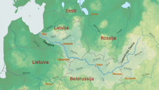
The Daugava or Western Dvina is a large river rising in the Valdai Hills of Russia that flows through Belarus and Latvia into the Gulf of Riga of the Baltic Sea. It rises close to the source of the Volga. It is 1,020 km (630 mi) in length, of which 352 km (219 mi) are in Latvia and 325 km (202 mi) are in Russia. It is a westward-flowing river, tracing out a great south-bending curve as it passes through northern Belarus.

<span class="mw-page-title-main">Geography of Finland</span> Overview of the geography of Finland

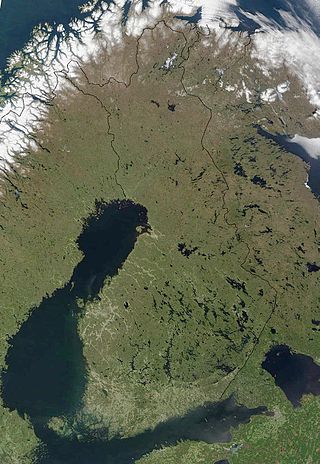
The geography of Finland is characterized by its northern position, its ubiquitous landscapes of intermingled boreal forests and lakes, and its low population density. Finland can be divided into three areas: archipelagoes and coastal lowlands, a slightly higher central lake plateau and uplands to north and northeast. Bordering the Baltic Sea, Gulf of Bothnia, and Gulf of Finland, as well as Sweden, Norway, and Russia, Finland is the northernmost country in the European Union. Most of the population and agricultural resources are concentrated in the south. Northern and eastern Finland are sparsely populated containing vast wilderness areas. Taiga forest is the dominant vegetation type.

<span class="mw-page-title-main">Gulf of Finland</span> Arm of the Baltic Sea

The Gulf of Finland is the easternmost arm of the Baltic Sea. It extends between Finland to the north and Estonia to the south, to Saint Petersburg in Russia to the east, where the river Neva drains into it. Other major cities around the gulf include Helsinki and Tallinn. The eastern parts of the Gulf of Finland belong to Russia, and some of Russia's most important oil harbors are located farthest in, near Saint Petersburg. As the seaway to Saint Petersburg, the Gulf of Finland has been and continues to be of considerable strategic importance to Russia. Some of the environmental problems affecting the Baltic Sea are at their most pronounced in the shallow gulf. Proposals for a tunnel through the gulf have been made.

<span class="mw-page-title-main">Geography of Kazakhstan</span> Overview of the geography of Kazakhstan

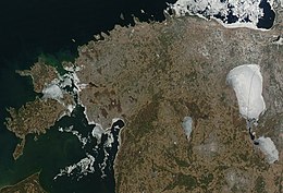
Kazakhstan is located in Central Asia. With an area of about 2,724,900 square kilometers (1,052,100 sq mi) Kazakhstan is more than twice the combined size of the other four Central Asian states and 60% larger than Alaska. The country borders Turkmenistan, Uzbekistan, and Kyrgyzstan to the south; Russia to the north; Russia and the Caspian Sea to the west; and China's Xinjiang Uygur Autonomous Region to the east.

<span class="mw-page-title-main">Geography of Latvia</span> Geographical features of Latvia

Latvia lies on the eastern shores of the Baltic Sea on the level northwestern part of the rising East European platform, between Estonia and Lithuania. About 98% of the country lies under 200 m (656 ft) elevation. With the exception of the coastal plains, the ice age divided Latvia into three main regions: the morainic Western and Eastern uplands and the Middle lowlands. Latvia holds over 12,000 rivers, only 17 of which are longer than 100 km (60 mi), and over 3,000 small lakes, most of which are eutrophic. The major rivers include the Daugava, the Lielupe, the Gauja, the Venta and the Salaca. Woodlands cover around 52% of the country. Other than peat, dolomite, and limestone, natural resources are scarce. Latvia has 504 km (313 mi) of sandy coastline, and the ports of Liepāja and Ventspils provide important warm-water harbors for the Baltic coast.

<span class="mw-page-title-main">Geography of Lithuania</span>

Lithuania is a country in the Baltic region of Europe. The most populous of the Baltic states, Lithuania has 262 km (163 mi) of coastline consisting of the continental coast and the "Curonian Spit" coast. Lithuania's major warm-water port of Klaipėda (Memel) lies at the narrow mouth of Curonian Lagoon, a shallow lagoon extending south to Kaliningrad and separated from the Baltic sea by Curonian Spit, where Kuršių Nerija National Park was established for its remarkable sand dunes.

<span class="mw-page-title-main">Saaremaa</span> Largest island in Estonia

Saaremaa is the largest and most populous island in Estonia, measuring 2,673 km2 (1,032 sq mi) and a recorded population of 31,435. The main island of the West Estonian archipelago, it is located in the Baltic Sea, south of Hiiumaa island and northwest of the Gulf of Riga. The administrative centre of the island, and of the Saare County, is the town of Kuressaare, which in January 2018 had 13,276 inhabitants. From the 13th century until the first half of the 20th century, the island of Saaremaa was known in most of the world by variants of its other historical name Ösel.

<span class="mw-page-title-main">Geography of the Netherlands</span> Overview of the geography of the European Netherlands

The geography of the European Netherlands is unusual in that much of its land has been reclaimed from the sea and is below sea level, protected by dikes. It is a small country with a total area of 41,545 km2 (16,041 sq mi) and ranked 131st. With a population of 17.4 million and density of 521/km2 (1,350/sq mi) makes it the second most densely populated member of the European Union after Malta, and the 12th most densely populated country in the world, behind only three countries with a population over 16 million. Consequently, the Netherlands is highly urbanized.

<span class="mw-page-title-main">Saare County</span> County of Estonia

Saare County is one of 15 counties of Estonia. It consists of Saaremaa, the largest island of Estonia, and several smaller islands near it, most notably Muhu, Ruhnu, Abruka and Vilsandi. The county borders Lääne County to the east, Hiiu County to the north, and Latvia to the south. In 2022 Saare County had a population of 31,292, which was 2.4% of the population of Estonia.

<span class="mw-page-title-main">Narva (river)</span> River between Estonia and Russia

The river Narva, formerly also Narwa or Narova, flows 77 kilometres (48 mi) north into the Baltic Sea and is the largest Estonian river by discharge. A similar length of land far to the south, together with it and a much longer intermediate lake, Lake Peipus, all together nowadays form the international border between Estonia and Russia.

<span class="mw-page-title-main">Gulf of Riga</span> Bay of the Baltic Sea between Latvia and Estonia

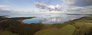
The Gulf of Riga, Bay of Riga, or Gulf of Livonia is a bay of the Baltic Sea between Latvia and Estonia.

<span class="mw-page-title-main">Ruhnu</span> Island in Estonia

Ruhnu is an Estonian island in the Gulf of Riga in the Baltic Sea. It is administratively part of Saare County but is geographically closer to the Latvian mainland. At 11.9 square kilometres (4.6 sq mi), it currently has 150 oficially declared inhabitants Ruhnu Parish has the smallest population of Estonia's 79 municipalities. Before 1944, it was for centuries populated by ethnic Swedes and traditional Swedish law was used.

<span class="mw-page-title-main">Kihnu</span> Island in Estonia

Kihnu is an island in the Baltic Sea. With an area of 16.4 km2 (6.3 sq mi), it is the largest island in the Gulf of Riga and the seventh largest island of Estonia. With a length of 7 km (4.3 mi) and width of 3.3 km (2.1 mi), the island's highest point is 8.9 metres (29.2 ft) above sea level.

<span class="mw-page-title-main">Rail transport in Estonia</span> Rail transport system in Estonia

The rail transport system in Estonia consists of about 1,200 kilometres (750 mi) of railway lines, of which 900 kilometres (560 mi) are currently in public use. The infrastructure of the railway network is mostly owned by the state and is regulated and surveyed by the Estonian Technical Surveillance Authority.

<span class="mw-page-title-main">Outline of Estonia</span> Overview of and topical guide to Estonia

The following outline is provided as an overview of and topical guide to Estonia:

<span class="mw-page-title-main">Geography of Belarus</span> Overview of the geography of Belarus

Belarus is a landlocked, generally flat country without natural borders, that occupies an area of 207,600 square kilometers (80,200 sq mi). Its neighbors are Russia to the east and northeast, Latvia to the north, Lithuania to the northwest, Poland to the west, and Ukraine to the south. Its extension from north to south is 560 km (350 mi), from west to east is 650 km (400 mi).

<span class="mw-page-title-main">Geography of Germany</span> Geographical features of Germany

Germany is a country in Central and Western Europe that stretches from the Alps, across the North European Plain to the North Sea and the Baltic Sea. It is the second-most populous country in Europe after Russia, and is seventh-largest country by area in the continent. The area of Germany ranked 63rd and covers 357,021 km2 (137,847 sq mi), consisting of 349,223 km2 (134,836 sq mi) of land and 7,798 km2 (3,011 sq mi) of waters, smaller than Japan but larger than Republic of the Congo.

<span class="mw-page-title-main">Estonia</span> Country in Northern Europe

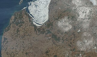
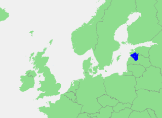
Estonia, officially the Republic of Estonia, is a country by the Baltic Sea in Northern Europe. It is bordered to the north by the Gulf of Finland across from Finland, to the west by the sea across from Sweden, to the south by Latvia, and to the east by Lake Peipus and Russia. The territory of Estonia consists of the mainland, the larger islands of Saaremaa and Hiiumaa, and over 2,200 other islands and islets on the eastern coast of the Baltic Sea, covering a total area of 45,339 square kilometres (17,505 sq mi). The capital city Tallinn and Tartu are the two largest urban areas of the country. The Estonian language is the indigenous and the official language of Estonia; it is the first language of the majority of its population, as well as the world's second most spoken Finnic language.

The geology of Estonia is the study of rocks, minerals, water, landforms and geologic history in Estonia. The crust is part of the East European Craton and formed beginning in the Paleoproterozoic nearly two billion years ago. Shallow marine environments predominated in Estonia, producing extensive natural resources from organic matter such as oil shale and phosphorite. The Mesozoic and much of the Cenozoic are not well-preserved in the rock record, although the glaciations during the Pleistocene buried deep valleys in sediment, rechanneled streams and left a landscape of extensive lakes and peat bogs.

References

  1. Raukas, Anto (2018). "Briefly about Estonia". Dynamiques Environnementales. 42 (42): 284–291. doi: 10.4000/dynenviron.2230 . ISSN   2534-4358 . Retrieved 5 March 2023.
  2. 1 2 3 4 5 6 7 8 9 10 11 12 13 14 15 16 17 18 19 20 21 22 23 24 25 26 27 28 29 30 31 32 33 34 35 36 PD-icon.svg This article incorporates text from this source, which is in the public domain :Pettai, Velio A. (1996). "Estonia: Physical Environment". In Iwaskiw, Walter R. (ed.). Estonia, Latvia & Lithuania: country studies (1st ed.). Washington, D.C.: Federal Research Division, Library of Congress. pp. 28–30. ISBN   0-8444-0851-4. OCLC   34245562.
  3. 1 2 3 4 5 6 7 8 9 10 11 12 13 PD-icon.svg This article incorporates text from this source, which is in the public domain : "Estonia". The World Factbook . Central Intelligence Agency. September 2, 2021. Retrieved September 10, 2021.
  4. Veski, Siim; Heinsalu, Atko; Lang, Valter; Kestlane, Ülo; Possnert, Göran (2004-08-01). "The age of the Kaali meteorite craters and the effect of the impact on the environment and man: Evidence from inside the Kaali craters, island of Saaremaa, Estonia". Vegetation History and Archaeobotany. 13 (3): 197–206. doi:10.1007/s00334-004-0043-x. S2CID   53476672.
  5. Animalia GBIF
  6. Auer, M.R., Raukas, A. (2002). Determinants of environmental cleanup in Estonia. Environment and Planning C: Government and Policy, 20: 679–698.