Related Research Articles

The ionosphere is the ionized part of the upper atmosphere of Earth, from about 48 km (30 mi) to 965 km (600 mi) above sea level, a region that includes the thermosphere and parts of the mesosphere and exosphere. The ionosphere is ionized by solar radiation. It plays an important role in atmospheric electricity and forms the inner edge of the magnetosphere. It has practical importance because, among other functions, it influences radio propagation to distant places on Earth. It also affects GPS signals that travel through this layer.
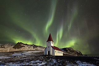
An aurora , also commonly known as the northern lights or southern lights, is a natural light display in Earth's sky, predominantly seen in high-latitude regions. Auroras display dynamic patterns of brilliant lights that appear as curtains, rays, spirals, or dynamic flickers covering the entire sky.

Space weather is a branch of space physics and aeronomy, or heliophysics, concerned with the varying conditions within the Solar System and its heliosphere. This includes the effects of the solar wind, especially on the Earth's magnetosphere, ionosphere, thermosphere, and exosphere. Though physically distinct, space weather is analogous to the terrestrial weather of Earth's atmosphere. The term "space weather" was first used in the 1950s and popularized in the 1990s. Later, it prompted research into "space climate", the large-scale and long-term patterns of space weather.

Earth's magnetic field, also known as the geomagnetic field, is the magnetic field that extends from Earth's interior out into space, where it interacts with the solar wind, a stream of charged particles emanating from the Sun. The magnetic field is generated by electric currents due to the motion of convection currents of a mixture of molten iron and nickel in Earth's outer core: these convection currents are caused by heat escaping from the core, a natural process called a geodynamo.

A geomagnetic storm, also known as a magnetic storm, is temporary disturbance of the Earth's magnetosphere caused by a solar wind shock wave.
A geomagnetic reversal is a change in a planet's magnetic field such that the positions of magnetic north and magnetic south are interchanged. The Earth's field has alternated between periods of normal polarity, in which the predominant direction of the field was the same as the present direction, and reverse polarity, in which it was the opposite. These periods are called chrons.

A Birkeland current is a set of electrical currents that flow along geomagnetic field lines connecting the Earth's magnetosphere to the Earth's high latitude ionosphere. In the Earth's magnetosphere, the currents are driven by the solar wind and interplanetary magnetic field and by bulk motions of plasma through the magnetosphere. The strength of the Birkeland currents changes with activity in the magnetosphere. Small scale variations in the upward current sheets accelerate magnetospheric electrons which, when they reach the upper atmosphere, create the Auroras Borealis and Australis. In the high latitude ionosphere, the Birkeland currents close through the region of the auroral electrojet, which flows perpendicular to the local magnetic field in the ionosphere. The Birkeland currents occur in two pairs of field-aligned current sheets. One pair extends from noon through the dusk sector to the midnight sector. The other pair extends from noon through the dawn sector to the midnight sector. The sheet on the high latitude side of the auroral zone is referred to as the Region 1 current sheet and the sheet on the low latitude side is referred to as the Region 2 current sheet.

The Super Dual Auroral Radar Network (SuperDARN) is an international scientific radar network consisting of 35 high frequency (HF) radars located in both the Northern and Southern Hemispheres. SuperDARN radars are primarily used to map high-latitude plasma convection in the F region of the ionosphere, but the radars are also used to study a wider range of geospace phenomena including field aligned currents, magnetic reconnection, geomagnetic storms and substorms, magnetospheric MHD waves, mesospheric winds via meteor ionization trails, and interhemispheric plasma convection asymmetries. The SuperDARN collaboration is composed of radars operated by JHU/APL, Virginia Tech, Dartmouth College, the Geophysical Institute at the University of Alaska Fairbanks, the Institute of Space and Atmospheric Studies at the University of Saskatchewan, the University of Leicester, Lancaster University, La Trobe University, the Solar-Terrestrial Environment Laboratory at Nagoya University, the British Antarctic Survey and the Institute for Space Astrophysics and Planetology.
An electrojet is an electric current which travels around the E region of the Earth's ionosphere. There are three electrojets: one above the magnetic equator, and one each near the Northern and Southern Polar Circles. Electrojets are Hall currents carried primarily by electrons at altitudes from 100 to 150 km. In this region the electron gyro frequency is much greater than the electron-neutral collision frequency. In contrast, the principal E region ions have gyrofrequencies much lower than the ion-neutral collision frequency.
The K-index quantifies disturbances in the horizontal component of Earth's magnetic field with an integer in the range 0–9 with 1 being calm and 5 or more indicating a geomagnetic storm. It is derived from the maximum fluctuations of horizontal components observed on a magnetometer during a three-hour interval. The label K comes from the German word Kennziffer meaning "characteristic digit". The K-index was introduced by Julius Bartels in 1939.
Geomagnetically induced currents (GIC) are electrical currents induced at the Earth's surface by rapid changes in the geomagnetic field caused by space weather events. GICs can affect the normal operation of long electrical conductor systems such as electric transmission grids and buried pipelines. The geomagnetic disturbances which induce GICs include geomagnetic storms and substorms where the most severe disturbances occur at high geomagnetic latitudes.

The L-shell, L-value, or McIlwain L-parameter is a parameter describing a particular set of planetary magnetic field lines. Colloquially, L-value often describes the set of magnetic field lines which cross the Earth's magnetic equator at a number of Earth-radii equal to the L-value. For example, describes the set of the Earth's magnetic field lines which cross the Earth's magnetic equator two earth radii from the center of the Earth. L-shell parameters can also describe the magnetic fields of other planets. In such cases, the parameter is renormalized for that planet's radius and magnetic field model.

The equatorial electrojet (EEJ) is a narrow ribbon of current flowing eastward in the day time equatorial region of the Earth's ionosphere. The abnormally large amplitude of variations in the horizontal components measured at equatorial geomagnetic observatories, as a result of EEJ, was noticed as early as 1920 from Huancayo geomagnetic observatory. Observations by radar, rockets, satellites, and geomagnetic observatories are used to study EEJ.
The dipole model of the Earth's magnetic field is a first order approximation of the rather complex true Earth's magnetic field. Due to effects of the interplanetary magnetic field (IMF), and the solar wind, the dipole model is particularly inaccurate at high L-shells, but may be a good approximation for lower L-shells. For more precise work, or for any work at higher L-shells, a more accurate model that incorporates solar effects, such as the Tsyganenko magnetic field model, is recommended.

The north magnetic pole, also known as the magnetic north pole, is a point on the surface of Earth's Northern Hemisphere at which the planet's magnetic field points vertically downward. There is only one location where this occurs, near the geographic north pole. The geomagnetic north pole is the northern antipodal pole of an ideal dipole model of the Earth's magnetic field, which is the most closely fitting model of Earth's actual magnetic field.
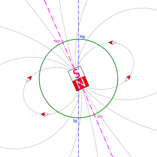
The geomagnetic poles are antipodal points where the axis of a best-fitting dipole intersects the surface of Earth. This theoretical dipole is equivalent to a powerful bar magnet at the center of Earth, and comes closer than any other point dipole model to describing the magnetic field observed at Earth's surface. In contrast, the magnetic poles of the actual Earth are not antipodal; that is, the line on which they lie does not pass through Earth's center.
The impact of the solar wind onto the magnetosphere generates an electric field within the inner magnetosphere - the convection field-. Its general direction is from dawn to dusk. The co-rotating thermal plasma within the inner magnetosphere drifts orthogonal to that field and to the geomagnetic field Bo. The generation process is not yet completely understood. One possibility is viscous interaction between solar wind and the boundary layer of the magnetosphere (magnetopause). Another process may be magnetic reconnection. Finally, a hydromagnetic dynamo process in the polar regions of the inner magnetosphere may be possible. Direct measurements via satellites have given a fairly good picture of the structure of that field. A number of models of that field exists.
In the height region between about 85 and 200 km altitude on Earth, the ionospheric plasma is electrically conducting. Atmospheric tidal winds due to differential solar heating or due to gravitational lunar forcing move the ionospheric plasma against the geomagnetic field lines thus generating electric fields and currents just like a dynamo coil moving against magnetic field lines. That region is therefore called ionospheric dynamo region. The magnetic manifestation of these electric currents on the ground can be observed during magnetospheric quiet conditions. They are called Sq-variations and L-variations (L=lunar) of the geomagnetic field. Additional electric currents are generated by the varying magnetospheric electric convection field. These are the DP1-currents and the polar DP2-currents. Finally, a polar-ring current has been derived from the observations which depends on the polarity of the interplanetary magnetic field. These geomagnetic variations belong to the so-called external part of the geomagnetic field. Their amplitudes reach at most about 1% of the main internal geomagnetic field Bo.

The solar storms of August 1972 were a historically powerful series of solar storms with intense to extreme solar flare, solar particle event, and geomagnetic storm components in early August 1972, during solar cycle 20. The storm caused widespread electric‐ and communication‐grid disturbances through large portions of North America as well as satellite disruptions. On 4 August 1972 the storm caused the accidental detonation of numerous U.S. naval mines near Haiphong, North Vietnam. The coronal mass ejection (CME)'s transit time from the Sun to the Earth is the fastest ever recorded.
References
- ↑ VanZandt, T. E.; W. L. Clark; J. M. Warnock (1972). "Magnetic apex coordinates: A magnetic coordinate system for the ionospheric F2 layer". J. Geophys. Res. 77 (13): 2406–2411. doi:10.1029/JA077i013p02406.
