India is situated north of the equator between 8°4' north to 37°6' north latitude and 68°7' east to 97°25' east longitude. It is the seventh-largest country in the world, with a total area of 3,287,263 square kilometres (1,269,219 sq mi). India measures 3,214 km (1,997 mi) from north to south and 2,933 km (1,822 mi) from east to west. It has a land frontier of 15,200 km (9,445 mi) and a coastline of 7,516.6 km (4,671 mi).

The Denison barb, Denison's barb, Miss Kerala, red-line torpedo barb, or roseline shark is an endangered species of cyprinid fish endemic to the fast-flowing hill streams and rivers of the Western Ghats in India. It is commonly seen in the aquarium trade; pet collection caused it to become endangered and is its single major threat.
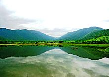
Nilambur is a major town, a municipality and a Taluk in the Malappuram district of the Indian state of Kerala. It is located close to the Nilgiris range of the Western Ghats on the banks of the Chaliyar River. This place is also known as 'Teak Town' because of the abundance of Nilambur teaks in this area; Which is a variety of a large, deciduous tree that occurs in mixed hardwood forests. Unlike many Municipalities of India; Nilambur is covered with large amounts of vegetation making it close to nature and hence make it very scenic and inspiring.

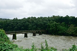
Chaliyar River is the fourth longest river in Kerala at 169 km in length. The Chaliyar is also known as Chulika River, Nilambur River or Beypore River as it nears the sea. Pothukal, Chungathara, Nilambur, Mampad, Edavanna, Kavanoor, Perakamanna, Areekode, Kizhuparamba, Elamaram, Cheekkode, Vazhakkad, Vazhayur, Cheruvadi, Edavannappara, Mavoor, Peruvayal, Feroke and Beypore are some of the towns/villages situated along the banks of Chaliyar. It mainly flows through Malappuram district. Its tributaries flow through both the districts of Malappuram and Kozhikode. The bank of river Chaliyar at Nilambur region is also known for natural Gold fields. Explorations done at the valley of the river Chaliyar in Nilambur has shown reserves of the order of 2.5 million cubic meters of placers with 0.1 gram per cubic meter of gold. It originates at Ilambaleri hills of Nilgiri Mountains in Nilgiris district, which is also near Wayanad-Malappuram district border. It flows mainly through the erstwhile region of Eranad, and finally empties into the Arabian Sea at Beypore port, opposite to Chaliyam harbour.

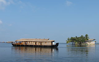
The Kerala backwaters are a network of brackish lagoons and canals lying parallel to the Arabian Sea of the Malabar coast of Kerala state in south-western India. It also includes interconnected lakes, rivers, and inlets, a labyrinthine system formed by more than 900 km (560 mi) of waterways, and sometimes compared to bayous. The network includes five large lakes linked by canals, both man made and natural, fed by 38 rivers, and extending virtually half the length of Kerala state. The backwaters were formed by the action of waves and shore currents creating low barrier islands across the mouths of the many rivers flowing down from the Western Ghats range. In the midst of this landscape there are a number of towns and cities, which serve as the starting and end points of backwater cruises. There are 34 backwaters in Kerala. Out of it, 27 are located either closer to Arabian Sea or parallel to the sea. The remaining 7 are inland navigation routes.

Vembanad is the longest lake in India, as well as the largest lake in the state of Kerala. The lake has an area of 230 square kilometers and a maximum length of 96.5 km. Spanning several districts in the state of Kerala, it is known as Vembanadu Lake in Kottayam, Vaikom, Changanassery, Punnamada Lake in Alappuzha, Punnappra, Kuttanadu and Kochi Lake in Kochi. Several groups of small islands including Vypin, Mulavukad, Maradu, Udayamperoor, Vallarpadam, and Willingdon Island are located in the Kochi Lake portion. Kochi Port is built around the Willingdon Island and the Vallarpadam island.

Palakkad Gap or Palghat Gap is a low mountain pass in the Western Ghats between Coimbatore in Tamil Nadu and Palakkad in Kerala. It has an average elevation of 140 metres (460 ft) with a width of 24–30 kilometres (15–19 mi). The pass is located between the Nilgiri Hills to the north and Anaimalai Hills to the south.

Periyar, IPA:[peɾijɐːr], is the longest river and the river with the largest discharge potential in the Indian state of Kerala. It is one of the few perennial rivers in the region and provides drinking water for several major towns. The Periyar is of utmost significance to the economy of Kerala. It generates a significant proportion of Kerala's electrical power via the Idukki Dam and flows along a region of industrial and commercial activity. The river also provides water for irrigation and domestic use throughout its course besides supporting a rich fishery. Due to these reasons, the river has been named the "Lifeline of Kerala". Kochi city, in the vicinity of the river mouth draws its water supply from Aluva, an upstream site sufficiently free of seawater intrusion. Twenty five percent of Kerala's industries are along the banks of river Periyar. These are mostly crowded within a stretch of 5 kilometres (3 mi) in the Eloor-Edayar region (Udhyogamandal), about 10 kilometres (6 mi) north of Kochi harbor.

Achankovil is a 128 km (80 mi) long west flowing river in Kerala, India. It flows through the districts of Kollam, Pathanamthitta and Alappuzha. The river drains vast tract of fertile plains of Upper Kuttanad in the Alappuzha and Pathanamthitta districts. It also sustains numerous urban settlements along its course such as Konni, Pathanamthitta, Pandalam and Mavelikkara.

The Pamba River is the longest river in the Indian state of Kerala after Periyar and Bharathappuzha, and the longest river in the erstwhile former princely state of Travancore. Sabarimala temple dedicated to Lord Ayyappa is located on the banks of the river Pamba.

Kerala is situated between the Lakshadweep Sea to the west and the Western Ghats to the east. Kerala's coast runs some 580 km in length, while the state itself varies between 35–120 km in width. Geologically, pre-Cambrian and Pleistocene formations comprise the bulk of Kerala's terrain. The topography consists of a hot and wet coastal plain gradually rising in elevation to the high hills and mountains of the Western Ghats. Kerala lies between northern latitude of 8°.17'.30" N and 12°. 47'.40" N and east longitudes 74°.27'.47" E and 77°.37'.12" E. Kerala's climate is mainly wet and maritime tropical, heavily influenced by the seasonal heavy rains brought up by the monsoon.
Kerala, officially Keralam, is a state on the Malabar Coast of India. It was formed on 1 November 1956, following the passage of the States Reorganisation Act, by combining Malayalam-speaking regions of the erstwhile regions of Cochin, Malabar, South Canara, and Travancore. Spread over 38,863 km2 (15,005 sq mi), Kerala is the 21st largest Indian state by area. It is bordered by Karnataka to the north and northeast, Tamil Nadu to the east and south, and the Lakshadweep Sea to the west. With 33 million inhabitants as per the 2011 census, Kerala is the 13th-largest Indian state by population. It is divided into 14 districts with the capital being Thiruvananthapuram. Malayalam is the most widely spoken language and is also the official language of the state.
Kadalundi River (Kadalundipuzha) is one of the four major rivers flowing through Malappuram district in the Indian state of Kerala. The other three are the Chaliyar, the Bharathappuzha and the Tirur River. This rain-fed river is 130 kilometres (81 mi) long and is one of the most important rivers in the district. Kadalundi River is also the sixth longest River in Kerala. Kadalundi River passes through [Karuvarakundu, Tuvvur [Melattur, Kerala|Melattur]], Pandikkad, Manjeri, Malappuram, Panakkad, Parappur, Vengara, Tirurangadi, Parappanangadi, Vallikkunnu, and empties itself into Arabian sea at Kadalundi Nagaram in Vallikkunnu on the northwestern border of the district. It is formed by the confluence of the Olippuzha River and the Veliyar River. The Kadalundi originates from the Western Ghats at the western border of the Silent Valley and flows through the district of Malappuram. It has two main tributaries namely Olipuzha and Veliyar. Olipuzha and Veliyar merges together to become Kadalundi River near Melattur. Kadalundi River traverses through the historical regions of Eranad and Valluvanad. The Kadalundi River drains an area of 1274 km² and has a length of 120 km. The ancient port of Tyndis, which was the second-largest trading port of Chera dynasty, only after to Muziris, is identified with the mouth of this river at Vallikunnu. The Kadalundi Bird Sanctuary spreads over a cluster of islands where the Kadalundipuzha River flows into the Arabian Sea. There are over a hundred species of native birds and around 60 species of migratory birds in large numbers annually.

Kerala, a state in Southern India, has a network of 11 National Highways, 72 State Highways and many district roads.

The Geography of South India comprises the diverse topological and climatic patterns of South India. South India is a peninsula in the shape of a vast inverted triangle, bounded on the west by the Arabian Sea, on the east by the Bay of Bengal and on the north by the Vindhya and Satpura ranges.

The West Coast Canal or National Waterway No 3 is a 205 km (127 mi) long inland navigational route located in Kerala, India, which runs from Kollam to Kottapuram. It was declared a National Waterway in 1993. In addition to the main stretch, Champakara and Udyogmandal canals are navigable and connect the industrial centers of Kochi to Kochi port Inland Waterways Authority of India (IWAI) under the Ministry of Shipping is coordinating the task for developing, monitoring and administering national waterways. It is the first National Waterway in the country with 24-hour navigation facilities along the entire stretch. It has been extended to Kozhikode by the National Waterways Act, 2016. The National Waterway 3 mainly passes through the previous Thiruvananthapuram–Shoranur canal.
Manimala River or Manimalayar is a 92km long river which flows through South and Central Kerala. The river used to be wrongly considered as a tributary of Pamba River before satellite maps became popular, but this was proved incorrect. Manimala does not flow into the Pamba, instead a distributary of the Pamba river flows into the Manimala river at Kallunkal, later branches out again from Manimala at Nedumpuram and flows through Niranam, Thalavady, Edathua, Changankary, Champakulam, Nedumudy, Chennamkary, and finally Kainakary and then empties into the Vembanad lake. This branch again links with Manimala river at Chennankary in a short, but broad connection known as Munnattumukham.

The Malabar Coast is the southwestern region of the Indian subcontinent. It generally refers to the western coastline of India stretching from Konkan to Kanyakumari. Geographically, it comprises one of the wettest regions of the subcontinent, which includes the Kanara region of Karnataka and all of Kerala.. The area was an important site in the trade routes of Kerala, and Christian missionaries first landed in India with the Portuguese traders operating here.
Waterways have always been an important mode of transport in Kerala. The total length of navigable route in Kerala was 1,900 kilometres and the navigable rivers constitute about 54 per cent of the waterways. The 41 West-flowing rivers together with the backwaters are an integrated part of the inland navigation system in Kerala. In Kerala water transportation through these channels are mainly small distant passenger services, informal country boats, freight transportation to PSU's such as Fertilisers and Chemicals Travancore, Kochi etc.

South Malabar refers to a geographical area of the southwestern coast of India covering some parts of the present-day Kerala. South Malabar covers the regions included in present-day Kozhikode taluk of Kozhikode district, the whole area of Malappuram district, Chavakkad taluk of Thrissur district, and Palakkad district, excluding parts of Chittur taluk. The Fort Kochi region of Kochi city also historically belongs to South Malabar. The term South Malabar refers to the region of the erstwhile Malabar District south to the river Korapuzha, and bears a high cultural similarity to both the Cochin and the North Malabar region.