
The Prospect of Whitby is a historic public house on the banks of the Thames at Wapping in the London Borough of Tower Hamlets. It lays claim to being the site of the oldest riverside tavern, dating from around 1520.
Wapping is a district in East London in the London Borough of Tower Hamlets and uniquely has it own postcode area E1W, which covers the entire area.
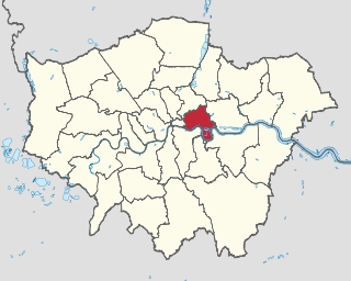
The London Borough of Tower Hamlets is a London borough located in East London; it covers much of the traditional East End. It was formed in 1965 from the merger of the former metropolitan boroughs of Stepney, Poplar and Bethnal Green. The new authority's unusual name comes from an alternative title for the Tower Division; the area of south-east Middlesex, focused on the area of the modern borough, which owed military service to the Tower of London.

Blackwall is a locale in East London, located in the London Borough of Tower Hamlets, it includes Leamouth and the conservation area of Coldharbour.

Millwall is a district on the western and southern side of the Isle of Dogs, in east London, England, in the London Borough of Tower Hamlets. It lies to the immediate south of Canary Wharf and Limehouse, north of Greenwich and Deptford, east of Rotherhithe, west of Cubitt Town, and has a long shoreline along London's Tideway, part of the River Thames. It was part of the County of Middlesex and from 1889 the County of London following the passing of the Local Government Act 1888, it later became part of Greater London in 1965.

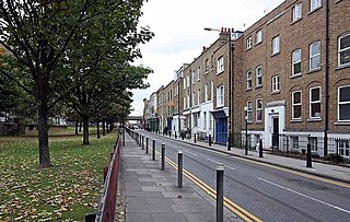
Narrow Street is a narrow road running parallel to the River Thames through the Limehouse area of east London, England. It used to be much narrower, and is the oldest part of Limehouse, with many buildings originating from the eighteenth century.

St. Andrew-by-the-Wardrobe is a Church of England church located on Queen Victoria Street, London in the City of London, near Blackfriars station.
Commercial Road is a street in the London Borough of Tower Hamlets in the East End of London. It is 1.9 miles (3.1 km) long, running from Gardiner's Corner, through Stepney to the junction with Burdett Road in Limehouse at which point the route splits into the East India Dock Road and the West India Dock Road. It is an artery connecting the historic City of London with the more recently developed financial district at Canary Wharf, and part of the A13.

Shackleford is a village and civil parish in the Borough of Guildford, Surrey, England centred to the west of the A3 between Guildford and Petersfield 32 miles (51 km) southwest of London and 5.2 miles (8.4 km) southwest of Guildford. Shackleford includes the localities of Eashing, Hurtmore, Norney and Gatwick.

Alton is a civil parish in Wiltshire, England. The parish includes the adjacent villages of Alton Barnes and Alton Priors, and the nearby hamlet of Honeystreet on the Kennet and Avon Canal. It lies in the Vale of Pewsey about 6 miles (10 km) east of Devizes.
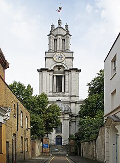
St Anne's Limehouse is a Hawksmoor Anglican Church in Limehouse, in the London Borough of Tower Hamlets. It was consecrated in 1730, one of the twelve churches built through the 1711 Act of Parliament.

High Offley is a small village and civil parish in Staffordshire, England. It lies 3 miles southwest of the small town of Eccleshall and about 1 mile west of the village of Woodseaves, both on the A519. Woodseaves is the largest settlement in the parish, which also includes the hamlet of Shebdon to the WSW of High Offley, as well as a number of scattered houses and small farms.

Berrynarbor is a village, civil parish, former manor and civil parish in the North Devon district of Devon, England. According to the 2001 census the parish had a population of 749, increasing to 802 at the 2011 census. The village is located on the north coast of the county to the north of Exmoor, about three miles east of Ilfracombe. The parish is surrounded clockwise from the east by the parishes of Combe Martin, Kentisbury, East Down, Marwood, Bittadon, and Ilfracombe. Berrynarbor has within its purview to all sides a mixture of dense woodlands and farms and lies within the North Devon Area of Outstanding Natural Beauty.

The Crown and Treaty is a pub on Oxford Road in Uxbridge, London, England, where Charles I and his Parliamentary opponents during the English Civil War held negotiations between 30 January and 22 February 1645. It is a Grade II* listed, dating from 1576.

The Wapping Hydraulic Power Station was originally run by the London Hydraulic Power Company in Wapping, London, England. Originally it operated using steam, and was later converted to use electricity. It was used to power machinery, including lifts, across London. The Tower Subway was used to transfer the power, and steam, to districts south of the river.

Verulam House is located in Verulam Road, St Albans on the northwestern side between Church Crescent and Britton Avenue opposite College Street. It has previously been referred to as Diocesan House and also known as the Bishop's Palace. It is of early nineteenth-century origin and is a Grade II Listed Building.

Dundee Wharf is a residential development in Limehouse in the London Borough of Tower Hamlets in London. The modern buildings occupy the site of a former shipyard known as Limekiln Dockyard. John Graves established this shipyard in 1633 and then expanded his holdings with Dundee Wharf itself. By 1650 George Margetts developed a ropemaking yard including a ropehouse, storehouse and a ropewalk on the site. A modern wharf with electric cranes was constructed in the 1930s. This was used by the Dundee, Perth & London Shipping Company to operate a twice-weekly service between Leith and London.
St George in the East is a former civil parish, mirrored by a continuing (extant) Church of England parish and narrower conservation area in Shadwell, in London, England. It is traditionally north of Wapping in the London Borough of Tower Hamlets. Its name has dropped out of most general use however is shown on many 21st century maps. The church, crypts and second floor outreach mission is open and holds regular services, as well as community organising and social justice campaigns.

The London Apprentice is a Grade II* listed public house at 62 Church Street, Isleworth, London.

Oliver's Wharf is a Grade II listed apartment building and former warehouse on the River Thames in Wapping High Street, Wapping, London.
