
Biggin Hill is a town in South East London, England, within the London Borough of Bromley. It is situated beyond London's contiguous built-up area in the Metropolitan green belt, 15.2 miles (24.5 km) south-southeast of Charing Cross. It is located adjacent to the Greater London boundary with Kent and Surrey. Prior to the creation of Greater London in 1965, it was in the historic and administrative county of Kent. At the 2011 Census, Biggin Hill had a population of 9,951.

Keston is a village in Greater London, England, located within the London Borough of Bromley, Greater London. Prior to 1965 it was within the historic county of Kent. It is part suburban, part rural in nature and lies on the edge of Hayes Common, just beyond the London conurbation to the south of Bromley Common. It includes the small hamlet of Nash to the southwest. The northern, more suburban part of Keston is sometimes referred to as Keston Mark.

The London Borough of Bromley is a borough in London, England. It borders the county of Kent, of which it formed part of until 1965. The borough's population in the 2021 census was 329,991. It is named after Bromley, its principal district. Other districts are Penge, Hayes, West Wickham, Chislehurst, Beckenham and Orpington. The local authority is Bromley London Borough Council.
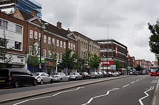
Bromley is a large town in Greater London, England, within the London Borough of Bromley. It is 9+1⁄2 miles southeast of Charing Cross, and had an estimated population of 88,000 as of 2023.

London Biggin Hill Airport is a minor commercial airport serving Biggin Hill in the London Borough of Bromley, located 12 NM south-southeast of Central London. It specialises in general aviation, handling a spectrum of traffic from private aviation to large business jets. It currently has no scheduled airline service, as flights using the airport are not regularly permitted to carry fare-paying passengers.

Downe, formerly Down, is a village in Greater London, England, located within the London Borough of Bromley but beyond London's contiguous urban area. Downe is 3.4 miles (5.5 km) south west of Orpington and 14.2 miles (22.9 km) south east of Charing Cross. Downe lies on a hill, and much of the centre of the village is unchanged; the former village school now acts as the village hall. The word Downe originates from the Anglo Saxon word dūn, latterly down, hence the South and North Downs. In April 1965, Downe and the remaining part of Orpington Urban District Council, was abolished, and transferred from the historic county of Kent and placed within the newly created London Borough of Bromley.
Westerham is a town and civil parish in the Sevenoaks District of Kent, England. It is located 3.4 miles east of Oxted and 6 miles west of Sevenoaks, adjacent to the Kent border with both Greater London and Surrey. It is recorded as early as the 9th century, and was mentioned in the Domesday Book in a Norman form, Oistreham. Hām is Old English for a village or homestead, and so Westerham means a westerly homestead. The River Darent flows through the town, and formerly powered three watermills.

Orpington is a constituency created in 1945 and represented in the House of Commons of the UK Parliament since 2019 by Gareth Bacon, a Conservative. It is the largest constituency in Greater London by area, covering the east and south of the London Borough of Bromley.
Berrima is a historic village in the Southern Highlands of New South Wales, Australia, in Wingecarribee Shire. The village, once a major town, is located on the Old Hume Highway between Sydney and Canberra. It was previously known officially as the Town of Berrima. It is close to the three major towns of the Southern Highlands: Mittagong, Bowral and Moss Vale.
Nuthurst is a village and civil parish in the Horsham district of West Sussex, England. The north of the parish borders Horsham town, with Nuthurst village 3 miles (5 km) south from the border. Within the parish is the estate and largely 19th-century country house of Sedgwick Park.
The TN postcode area, also known as the Tunbridge Wells postcode area, is a group of 40 postcode districts in England, within 24 post towns. These cover south and west Kent and northern and eastern East Sussex, plus very small parts of Surrey and the London Borough of Bromley.

Stalisfield is a village in the borough of Swale in Kent, England, located on a secondary road about 1½ miles (2.4 km) north of Charing and 5 miles south west of Faversham. The parish includes the hamlet of Stalisfield Green.
Transportation needs within the county of Kent in South East England has been served by both historical and current transport systems.

Langdon is a civil parish in the Dover district of Kent, England, and contains the villages of East Langdon and West Langdon, and the hamlets of Martin and Martin Mill. Langdon was the site of Langdon Abbey which was dissolved in 1535.
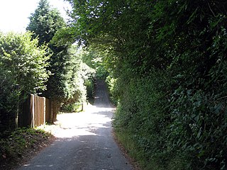
Berry's Green a small hamlet in the London Borough of Bromley in Greater London, UK, situated outside of London's contiguous built-up area. It is a fairly wooded rural area with a scattering of farmland. Housing consists mainly of detached properties, mostly bungalows, with a row of local authority cottages and a static mobile home site. It is part of the largest ward in Greater London, Darwin (ward). When the Ward was first constituted in 1965, Berry's Green, was joined with Downe, Cudham, Leaves Green, Single Street, Luxted, and Westerham Hill. The current elected political party's website (2022), states the present named other areas as Downe, Cudham, Leaves Green, Leavesden Estate, Westerham Hill, Beechwood, and Pratts Bottom
The lost village of Werps was one of a group of small settlements which later became collectively known as Jackfield in the Broseley Parish in Shropshire. The Werps lay on the south side of the river Severn, opposite the Old Coalport China Works and records indicate either three or four public houses, although it is unclear as to whether any of their names are renames of the same building or whether re-built on the same site.

Horsington is a village and civil parish in the East Lindsey district of Lincolnshire, England. It lies on the B1190, 4 miles (6.4 km) north from Woodhall Spa and 6 miles (10 km) west from Horncastle as well as 6 miles east of Bardney. The parish includes the hamlet of Poolham which is situated 1 mi (1.6 km) to the east of the village.

Tydd Gote is an English village, partly, at the north, in the civil parish of Tydd St Mary of the South Holland District of Lincolnshire, and partly, at the south, in the civil parish of Tydd St Giles of the Fenland District of Cambridgeshire.
The Southern Heights Light Railway (SHLR) was to have been a speculative London area suburban electric railway between Orpington, Kent and Sanderstead, Surrey. It was authorised in 1928 under the Light Railways Act 1896, but ultimately not constructed. The engineer was to have been Colonel Holman Fred Stephens, heavily involved in the promotion of light railways.


