
Soho is an area of the City of Westminster in the West End of London. Originally a fashionable district for the aristocracy, it has been one of the main entertainment districts in the capital since the 19th century.

Oxford Circus is a road junction connecting Oxford Street and Regent Street in the West End of London. It is also the entrance to Oxford Circus tube station.

The Angel, Islington, is a historic landmark and a series of buildings that have stood on the corner of Islington High Street and Pentonville Road in Islington, London, England. The land originally belonged to the Clerkenwell Priory and has had various properties built on it since the 16th century. An inn on the site was called the "Angel Inn" by 1614, and the crossing became generally known as "the Angel". The site was bisected by the New Road, which opened in 1756, and properties on the site have been rebuilt several times up to the 20th century. The corner site gave its name to Angel tube station, opened in 1901, and the surrounding Angel area of London.

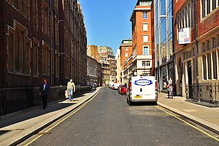
Berwick Street is a street in the Soho district of the City of Westminster, running between Oxford Street to the north and Peter Street at the south. It was built towards the end of the 17th century; several early 18th century buildings have survived. A market was established on the street in the 19th century.

Great Marlborough Street is a thoroughfare in Soho, Central London. It runs east of Regent Street past Carnaby Street towards Noel Street.

Soho Square is a garden square in Soho, London, hosting since 1954 a de facto public park let by the Soho Square Garden Committee to Westminster City Council. It was originally called King Square after Charles II, and a much weathered statue of the monarch has stood in the square, with an extended interruption, since 1661, one year after the restoration of the monarchy.

Essex Road is a main road in Islington, London. It is part of the A104 and connects Islington High Street with Balls Pond Road via Essex Road railway station.

Vincent Square is a grass-covered square in Westminster, London, England, covering 13 acres, lined with mature trees including London Planes. In among a network of backstreets, it chiefly provides playing fields for Westminster School, who own it absolutely; otherwise, it functions as a green lung and a view for the homes, hotel and other organisations adjoining. Nine of its adjoining buildings have been given strict statutory architectural recognition and protection.
Chancery Lane is a one-way street that forms part of the western boundary of the City of London. The east side of the street is entirely within the City, whilst the west side is in the City of Westminster south of Carey Street and the London Borough of Camden north of that street. The route originated as a 'new lane' created by the Knights Templar from their original 'old Temple' on the site of the present Southampton Buildings on Holborn, in order to access to their newly acquired property to the south of Fleet Street sometime before 1161.

Piccadilly Arcade runs between Piccadilly and Jermyn Street in central London. It was opened in 1909, having been designed by Thrale Jell, and is a Grade II listed building.

Caxton Hall is a building on the corner of Caxton Street and Palmer Street, in Westminster, London, England. It is a Grade II listed building primarily noted for its historical associations. It hosted many mainstream and fringe political and artistic events and after the Second World War was the most popular register office used by high society and celebrities who required a civil marriage.

Conduit Street is a street in Mayfair, London. It connects Bond Street to Regent Street.
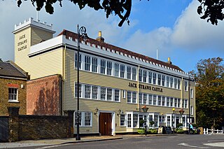
Jack Straw's Castle is a Grade II listed building and former public house on North End Way, Hampstead, north-west London, England close to the junction with Heath Street and Spaniards Road.

Rathbone Place is a street in central London that runs roughly north-west from Oxford Street to Percy Street. it is joined on its eastern side by Percy Mews, Gresse Street, and Evelyn Yard. The street is mainly occupied by retail and office premises.

The Mitre Inn is a public house at 58 High Street, Chipping Barnet, London. It was established by 1633 and is probably the oldest remaining of the town's once numerous coaching inns. It is a grade II listed building with Historic England and is currently styled "Ye Olde Mitre Inne".

Homer Row is a street in the Marylebone district of the City of Westminster, London, that runs form Old Marylebone Road in the north to the junction of Crawford Place and Crawford Street in the south.
Essex Street is a street in the City of Westminster that runs from Milford Lane in the south to Strand in the north. It is joined by Little Essex Street on its western side and Devereux Court on the eastern side. It was laid out by Nicholas Barbon in around 1675 or 1680 and contains a number of listed buildings.

The Cheshire Cheese is a public house at 5 Little Essex Street, London WC2, on the corner with Milford Lane.

South Audley Street is a major shopping street in Mayfair, London. It runs north to south from the southwest corner of Grosvenor Square to Curzon Street.

Kinnerton Street is in the district of Belgravia in the City of Westminster, London, England. It had modest origins as a service street for wealthy areas of the Grosvenor Estate and was originally occupied by the animals, servants, shopkeepers and tradesmen who served their richer neighbours. The small side streets on its west side end at the Ranelagh Sewer which was not covered over until 1844. The street was the site of a medical school where the dissecting was carried out for Gray's Anatomy. Later, the street was gentrified.

