
The London Borough of Hammersmith and Fulham is a London borough in West London and which also forms part of Inner London. The borough was formed in 1965 as the London Borough of Hammersmith from the merger of the former Metropolitan Boroughs of Fulham and Hammersmith. The name was changed to Hammersmith and Fulham in 1979. The borough borders Brent to the north, the Royal Borough of Kensington and Chelsea to the east, Wandsworth to the south, Richmond upon Thames to the south west, and Hounslow and Ealing to the west.

Hammersmith is a district of West London, England, 4.3 miles (6.9 km) southwest of Charing Cross. It is the administrative centre of the London Borough of Hammersmith and Fulham, and identified in the London Plan as one of 35 major centres in Greater London.
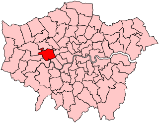
Ealing, Acton and Shepherd's Bush was a parliamentary constituency represented in the House of Commons of the Parliament of the United Kingdom. It elected one Member of Parliament (MP) by the first past the post system of election. The constituency was abolished at the 2010 general election when it was divided between the new seats of Ealing Central and Acton and Hammersmith, with then incumbent Andy Slaughter becoming MP for the latter seat.
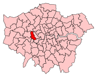
Hammersmith was a parliamentary constituency in the House of Commons of the UK Parliament represented from 2010 until its abolition for the 2024 general election by Andy Slaughter, a member of the Labour Party.
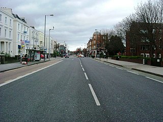
Uxbridge Road is the name of the A4020 road in West London. The 12-mile (19 km) route starts at Shepherd's Bush Green and goes west towards Uxbridge. It passes through Acton, Ealing, Hanwell, Southall, Hayes, and Hillingdon.
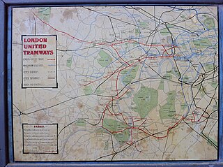
London United Tramways Company Limited was an operator of trams and trolleybuses in the western and southern suburbs of London, UK, from 1894 to 1933, when it passed to the London Passenger Transport Board.
Westfield London is a large shopping centre in White City, west London, England, developed by the Westfield Group at a cost of £1.6bn, on a brownfield site formerly the home of the 1908 Franco-British Exhibition. The site is bounded by the West Cross Route (A3220), the Westway (A40) and Wood Lane (A219). It opened on 30 October 2008 and became the largest covered shopping development in the capital; originally a retail floor area of 1,600,000 sq ft (150,000 m2), further investment and expansion led to it becoming the largest shopping centre in the UK and Europe by March 2018, an area of 2,600,000 sq ft (240,000 m2).

Shepherd's Bush Green is an approximately 8-acre (3.2 ha) triangular area of open grass surrounded by trees and roads with shops in Shepherd's Bush, an area of west London which takes its name from the Green. The Green is also a ward of the London Borough of Hammersmith and Fulham. The population of the ward at the 2011 Census was 12,175.

Shepherd's Bush Market is a street market in Shepherd's Bush, London. The market is located on the east side of the railway viaduct for the Hammersmith and City Tube line, and is bordered on the north side by the Uxbridge Road, and on the south by the Goldhawk Road.
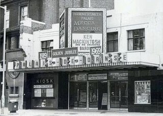
The Hammersmith Palais de Danse, in its last years simply named Hammersmith Palais, was a dance hall and entertainment venue in Hammersmith, London, England that operated from 1919 until 2007. It was the first palais de danse to be built in Britain. In 2009, it was named by the Brecon Jazz Festival as one of twelve venues which had made the most important contributions to jazz music in the United Kingdom.
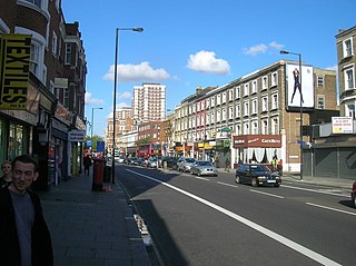
Goldhawk Road is a road in west London, England, which starts at Shepherd's Bush and travels west. There are numerous shops, restaurants and businesses lining the road, which forms the southern boundary of Shepherd's Bush Green. It is designated part of the A402 road.

Hammersmith Fire Station is a Grade II listed building at 244 Shepherd's Bush Road, Hammersmith, London W6 7NL.
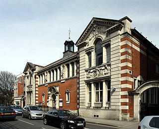
Hammersmith Library is a Grade II listed building at Shepherd's Bush Road, Hammersmith, London W6 7AT.

King Street, Hammersmith is the main shopping street in Hammersmith, London. It runs west–east, and forms part of the A315, and is the eastern continuation of Chiswick High Road, where it meets Goldhawk Road, close to Stamford Brook tube station. At the eastern end it meets Hammersmith Broadway and continues east as Hammersmith Road where it forms a crossroads with the A219, the Shepherd's Bush Road running northwards, and the Fulham Palace Road running south.

The Coachmakers Arms is a former pub at 135 King Street, Hammersmith, London.
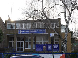
Ravenscourt Baptist Church is a church in Ravenscourt Road, Hammersmith, London. It was established in 1793 as the West End Baptist Church. The current building opposite the Ravenscourt Park tube station opened in 1971.
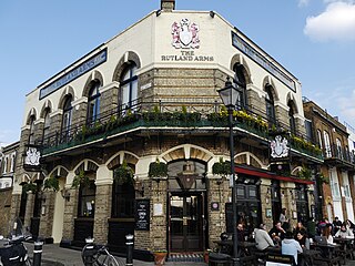
The Rutland Arms is a public house at 15 Lower Mall, Hammersmith, London, England. It was also called the Rutland Hotel.

The Queen Adelaide is a pub at 412 Uxbridge Road, Shepherd's Bush, London W12. It is a Greene King property.
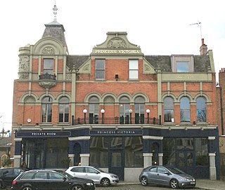
The Princess Victoria is a public house and former gin palace on the Uxbridge Road, Shepherd's Bush, London W12. First opened in 1829, it closed in June 2017 when its parent company, Affinity Bars and Restaurants, became insolvent, but re-opened in November 2017 under new operators Three Cheers Pub Company.
St Stephen's School is a Church of England primary school for girls and boys located on the Uxbridge Road in Shepherd's Bush, in the London Borough of Hammersmith and Fulham, England. It is affiliated with St Stephen's Church, Shepherd's Bush, in the Diocese of London, and was built at the same time, circa 1849–50. As of 2011 St Stephen's was rated "outstanding" by Ofsted. In 2017 it was ranked equal fifth in the Sunday Times list of the top 500 State Primary Schools in the UK and also featured in The Tatler's list of Best State Primary Schools.
