
The Globe is a pub at 83 Moorgate, London.
It is a Grade II listed building, built in the early 19th century. [1]
The Globe is a pub at 83 Moorgate, London.
It is a Grade II listed building, built in the early 19th century. [1]

Old Street is a 1-mile (1.6 km) street in inner north-east Central London, England that runs west to east from Goswell Road in Clerkenwell, in the London Borough of Islington, via St Luke's and Old Street Roundabout, to the crossroads where it meets Shoreditch High Street (south), Kingsland Road (north) and Hackney Road (east) in Shoreditch in the London Borough of Hackney.
Moorgate was one of the City of London, England's northern gates in its defensive wall, the last to be built. The gate took its name from the Moorfields, an area of marshy land that lay immediately north of the wall.


Citypoint is a building located on Ropemaker Street on the northern fringe of the City of London, the main financial district and historic nucleus of London.
The EC postcode area, also known as the London EC postal area, is a group of postcode districts in central London, England. It includes almost all of the City of London and parts of the London boroughs of Islington, Camden, Hackney, Tower Hamlets and Westminster. The area covered is of very high density development. Deliveries for the EC postcode area are made from Mount Pleasant Mail Centre.

Finsbury Pavement is a short length of street in England connecting Moorgate with City Road in the London Borough of Islington. It forms a part of the London Inner Ring Road, and before the introduction of the ring of steel around the City of London it formed a major through-route towards London Bridge and south London.
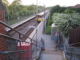
Watton-at-Stone railway station serves the village of Watton-at-Stone in Hertfordshire, England. It is 23 miles 72 chains down the line from London King's Cross on the Hertford Loop Line between Hertford North and Stevenage and is served by trains operated by Great Northern.

Bunhill Row is a street located in St Luke's, London Borough of Islington, London. The street runs north–south from Old Street to Chiswell Street. On the east side are the cemetery of Bunhill Fields and the open space of the Honourable Artillery Company's Artillery Ground.
Ark Globe Academy is a mixed all-through school located in Southwark, London, England.
Electra House is a building at 84 Moorgate, London, England. It is notable as the wartime London base of Cable & Wireless Limited, and office of Department EH — one of the three British organisations that merged in World War II to form the Special Operations Executive.

The Liverpool Street signal box is a Grade II listed disused signal box at Liverpool Street tube station in London.

The George and Dragon is a Grade II listed public house at 151 Cleveland Street, Fitzrovia, London W1T 6QN.

The Rose and Crown is a Grade II listed public house at 199 Stoke Newington Church Street, Stoke Newington, Hackney, London, N16 9ES.

The Angel is a Grade II listed public house at 697 Uxbridge Road, Hayes, Middlesex, UB4 8HX.
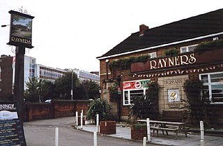
Rayners is a Grade II listed public house at 23 Village Way East, Rayners Lane, Harrow, London HA2 7LX.

The New Barnet War Memorial stands on a triangular plot at the junction of Station Road and Lyonsdown Road, New Barnet. It is grade II listed with Historic England.

The Fox is a pub at 39 Church Street, Twickenham, London TW1.

The Crown is a pub at 174 Richmond Road, Twickenham, London TW1. It is a Grade II listed building, dating back to the late 18th century.

The Jolly Coopers is a pub at 16 High Street, Hampton TW12 2SJ in the London Borough of Richmond upon Thames.

The Jugged Hare is a public house and restaurant at 49 Chiswell Street, between Barbican and Moorgate underground stations in the City of London.
51°31′04″N0°05′20″W / 51.517669°N 0.0888048°W
| | This article about a London building or structure is a stub. You can help Wikipedia by expanding it. |
| | This pub-related article is a stub. You can help Wikipedia by expanding it. |