
The George Washington Bridge is a double-decked suspension bridge spanning the Hudson River, connecting Fort Lee in Bergen County, New Jersey, with the Washington Heights neighborhood of Manhattan in New York City. It is named after Founding Father George Washington, the first president of the United States. The George Washington Bridge is the world's busiest motor vehicle bridge, carrying a traffic volume of over 104 million vehicles in 2019, and is the world's only suspension bridge with 14 vehicular lanes.
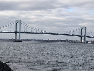
The Throgs Neck Bridge is a suspension bridge in New York City, carrying six lanes of Interstate 295 (I-295) over the East River where it meets the Long Island Sound. The bridge connects the Throggs Neck section of the Bronx with the Bay Terrace section of Queens.

The Robert F. Kennedy Bridge is a complex of bridges and elevated expressway viaducts in New York City. The bridges link the boroughs of Manhattan, Queens, and the Bronx. The viaducts cross Randalls and Wards Islands, previously two islands and now joined by landfill.
The Harlem River is an 8-mile (13 km) tidal strait in New York, United States, flowing between the Hudson River and the East River and separating the island of Manhattan from the Bronx on the New York mainland.
Interstate 278 (I-278) is an auxiliary Interstate Highway in New Jersey and New York in the United States. The road runs 35.62 miles (57.32 km) from US Route 1/9 (US 1/9) in Linden, New Jersey, northeast to the Bruckner Interchange in the New York City borough of the Bronx. The majority of I-278 is in New York City, where it serves as a partial beltway and passes through all five of the city's boroughs. I-278 follows several freeways, including the Union Freeway in Union County, New Jersey; the Staten Island Expressway (SIE) across Staten Island; the Gowanus Expressway in southern Brooklyn; the Brooklyn–Queens Expressway (BQE) across northern Brooklyn and Queens; a small part of the Grand Central Parkway in Queens; and a part of the Bruckner Expressway in the Bronx. I-278 also crosses multiple bridges, including the Goethals, Verrazzano-Narrows, Kosciuszko, and Robert F. Kennedy bridges.

The Bronx–Whitestone Bridge is a suspension bridge in New York City, carrying six lanes of Interstate 678 over the East River. The bridge connects Throggs Neck and Ferry Point Park in the Bronx, on the East River's northern shore, with the Whitestone neighborhood of Queens on the southern shore.

The Cross Bronx Expressway is a major freeway in the New York City borough of the Bronx. It is mainly designated as part of Interstate 95 (I-95), but also includes portions of I-295 and U.S. Route 1 (US 1). The Cross Bronx begins at the eastern approach to the Alexander Hamilton Bridge over the Harlem River. While I-95 leaves at the Bruckner Interchange in Throgs Neck, following the Bruckner Expressway and New England Thruway to Connecticut, the Cross Bronx Expressway continues east, carrying I-295 to the merge with the Throgs Neck Expressway near the Throgs Neck Bridge. Though the road goes primarily northwest-to-southeast, the nominal directions of all route numbers west of the Bruckner Interchange are aligned with the northbound route number going southeast, and the southbound route number going northwest.

Interstate 678 (I-678) is a north–south auxiliary Interstate Highway that extends for 14 miles (23 km) through two boroughs of New York City. The route begins at John F. Kennedy International Airport on Jamaica Bay and travels north through Queens and across the East River to the Bruckner Interchange in the Bronx, where I-678 ends and the Hutchinson River Parkway begins.

The Broadway Bridge is a vertical-lift bridge across the Harlem River Ship Canal in the borough of Manhattan in New York City. It connects the neighborhoods of Inwood on Manhattan Island and Marble Hill on the mainland. The bridge consists of two decks. The lower deck carries Broadway, which is designated as U.S. Route 9 at this location. The upper deck carries the New York City Subway's IRT Broadway–Seventh Avenue Line, serving the 1 train.
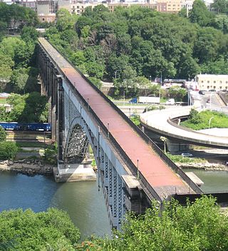
The High Bridge is the oldest bridge in New York City, having originally opened as part of the Croton Aqueduct in 1848 and reopened as a pedestrian walkway in 2015 after being closed for over 45 years. A steel arch bridge with a height of 140 ft (43 m) over the Harlem River, it connects the New York City boroughs of the Bronx and Manhattan. The eastern end is located in the Highbridge section of the Bronx near the western end of West 170th Street, and the western end is located in Highbridge Park in Manhattan, roughly parallel to the end of West 174th Street.
The Macombs Dam Bridge is a swing bridge across the Harlem River in New York City, connecting the boroughs of Manhattan and the Bronx. The bridge is operated and maintained by the New York City Department of Transportation (NYCDOT).

Harlem River Drive is a 4.20-mile (6.76 km) controlled-access parkway in the New York City borough of Manhattan. It runs along the west bank of the Harlem River from the Triborough Bridge in East Harlem to 10th Avenue in Inwood, where the parkway ends and the road continues northwest as Dyckman Street. South of the Triborough Bridge, the parkway continues toward lower Manhattan as FDR Drive. All of Harlem River Drive is designated New York State Route 907P (NY 907P), an unsigned reference route.

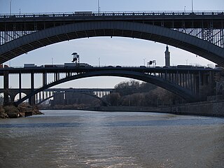
The Washington Bridge is a 2,375-foot (724 m)-long arch bridge over the Harlem River in New York City between the boroughs of Manhattan and the Bronx. The crossing, opened in 1888, connects 181st Street and Amsterdam Avenue in Washington Heights, Manhattan, with University Avenue in Morris Heights, Bronx. It carries six lanes of traffic, as well as sidewalks on both sides. Ramps at either end of the bridge connect to the Trans-Manhattan Expressway and the Cross Bronx Expressway.

Interstate 95 (I-95) is part of the Interstate Highway System and runs from Miami, Florida, to the Canada–United States border near Houlton, Maine. In the US state of New York, I-95 extends 23.50 miles (37.82 km) from the George Washington Bridge in New York City to the Connecticut state line at Port Chester. The George Washington Bridge carries I-95 across the Hudson River from New Jersey into New York City. There, I-95 runs across Upper Manhattan on the Trans-Manhattan Expressway for 0.81 miles (1.30 km) through Washington Heights. It continues east across the Harlem River on the Alexander Hamilton Bridge and onto the Cross Bronx Expressway. In the Bronx, I-95 leaves the Cross Bronx at the Bruckner Interchange, joining the Bruckner Expressway to its end. North of the interchange with Pelham Parkway, it then continues northeast via the New England Thruway out of New York City into Westchester County and to the Connecticut state line, where I-95 continues on the Connecticut Turnpike.
Interstate 78 (I-78) is a part of the Interstate Highway System that runs from Union Township, Lebanon County, Pennsylvania, to New York City. In the US state of New York, I-78 extends 1⁄2 mile (800 m). The entirety of I-78 consists of the Holland Tunnel, which crosses under the Hudson River from New Jersey and ends at an exit rotary in Lower Manhattan. The tunnel and its approaches are maintained by the Port Authority of New York and New Jersey (PANYNJ).

The Third Avenue Bridge carries southbound road traffic on Third Avenue over the Harlem River, connecting the boroughs of Manhattan and the Bronx in New York City. It once carried southbound New York State Route 1A. The Third Avenue Bridge carries traffic south from the intersections of either Third Avenue and East 135th Street, or Bruckner Boulevard and Lincoln Avenue, in the Bronx. On the Manhattan side, the bridge funnels traffic into three locations: East 128th Street; the intersection of East 129th Street and Lexington Avenue; or FDR Drive in Manhattan.

The Harlem River Lift Bridge is a vertical lift bridge carrying the Metro-North Railroad's Hudson Line, Harlem Line, and New Haven Line across the Harlem River between the boroughs of Manhattan and the Bronx in New York City. The average weekday ridership on the lines is 265,000.

The University Heights Bridge is a steel-truss revolving swing bridge across the Harlem River in New York City. It connects West 207th Street in the Inwood neighborhood of Manhattan with West Fordham Road in the University Heights neighborhood of the Bronx. The bridge is operated and maintained by the New York City Department of Transportation.

U.S. Route 1 (US 1) is a part of the U.S. Highway System that extends from Key West, Florida, to the Canada–United States border at Fort Kent, Maine. In the U.S. state of New York, US 1 extends 21.54 miles (34.67 km) from the George Washington Bridge in Manhattan to the Connecticut state line at Port Chester. It closely parallels Interstate 95 (I-95) for much of its course and does not serve as a major trunk road within the state. It is not concurrent with any other highways besides I-95 and (briefly) US 9, and few other state highways intersect it.

The 178th and 179th Street Tunnels are two disused vehicular tunnels in Upper Manhattan in New York City. Originally conceived and constructed under the auspices of Robert Moses, the twin tunnels have been superseded by the Trans-Manhattan Expressway in Washington Heights, which itself runs through a cut with high-rise apartments built over it in places.


