
Fond du Lac County is a county in the U.S. state of Wisconsin. As of the 2020 census, the population was 104,154. Its county seat is Fond du Lac. The county was created in the Wisconsin Territory in 1836 and later organized in 1844. Fond du Lac is French for "bottom of the lake", given so because of the county's location at the southern shore of Lake Winnebago. Fond du Lac County comprises the Fond du Lac, Wisconsin Metropolitan Statistical Area. The Holyland region is in northeastern Fond du Lac County.
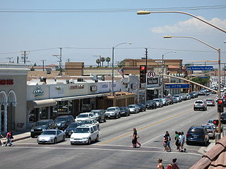
Artesia is a city in southeast Los Angeles County, California. Artesia was incorporated on May 29, 1959, and is one of Los Angeles County's Gateway Cities. The city has a 2010 census population of 16,522. Artesia is surrounded on the west, south, and east sides by Cerritos, with Norwalk to the north. Artesia is the home of the East West Ice Palace, an ice rink which is co-owned by Michelle Kwan. It was also the childhood home of former First Lady Pat Nixon, who lived there from 1914 to 1931, though the property on which she grew up is now part of neighboring Cerritos.
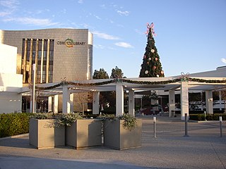
Cerritos is a city in Los Angeles County, California, United States, and is one of several cities that constitute the Gateway Cities of southeast Los Angeles County. It was incorporated on April 24, 1956. As of 2019, the population was 49,859. It is part of the Los Angeles–Long Beach–Anaheim, California Metropolitan Statistical Area designated by the Office of Management and Budget.

Higgins Township is a civil township of Roscommon County in the U.S. state of Michigan. The population was 1,983 at the 2010 census. The village of Roscommon is located within the township.

Artesia is a town in Lowndes County, Mississippi. The population was 304 at the 2020 census, down from 440 at the 2010 census.

Artesia is a city in Eddy County, New Mexico, centered at the intersection of U.S. routes 82 and 285; the two highways serve as the city's Main Street and First Street, respectively. As of the 2010 census, the city population was 11,301.
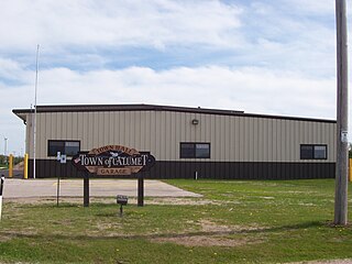
Calumet is a town in Fond du Lac County, Wisconsin, United States. The population was 1,514 at the 2000 census. The unincorporated communities of Artesia Beach, Calumet Harbor, Garnet, Highland Park, Johnsburg, Laudolff Beach, Marytown, Pipe, Pukwana Beach, Winnebago Heights, and Winnebago Park are located within the town. The unincorporated community of Calumetville is located partially in the town.

State Route 91 (SR 91) is a major east–west state highway in the U.S. state of California that serves several regions of the Greater Los Angeles urban area. A freeway throughout its entire length, it officially runs from Vermont Avenue in Gardena, just west of the junction with the Harbor Freeway, east to Riverside at the junction with the Pomona and Moreno Valley freeways.
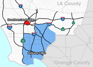
The Gateway Cities Region, or Southeast Los Angeles County is an urbanized region located in southeastern Los Angeles County, California, between the City of Los Angeles proper, Orange County, and the Pacific Ocean. The cluster of cities has been termed "Gateway Cities" in that they serve as a "gateway" between the LA and Orange counties, with the city of Cerritos equidistant from Downtown L.A., Long Beach, and Santa Ana in Orange County. As such, the area is central to the Los Angeles-Long Beach-Anaheim, CA Metropolitan Statistical Area (MSA), and has a population of approximately 2,000,000 residents.
Artesia is the historical Latin and Spanish name of Artois in northern France. The name ultimately derived from the Belgic tribe the Atrebates. The county gave its name to Artesian wells, which were drilled there since the 12th century.

The ABC Unified School District is a school district that is based in Cerritos, California, United States.

North Long Beach is a predominantly working-class area of Long Beach, California. The neighborhood is bounded to the west, north and east by the Long Beach city limits, and to the south by a Union Pacific railroad track and the Bixby Knolls neighborhood. The north boundary with Paramount is only a few blocks north of the Artesia Freeway.

Artesia Station is an at-grade light rail station on the A Line of the Los Angeles Metro Rail system. The station is located alongside the Union Pacific freight railroad's Wilmington Subdivision, at its intersection with Artesia Boulevard, after which the station is named, in the city of Compton, California.

Artesia Township is one of twenty-six townships in Iroquois County, Illinois, USA. As of the 2010 census, its population was 945 and it contained 428 housing units. Artesia Township formed from portions of Ash Grove and Loda townships sometime prior to 1921.
Artesia Boulevard is a west-east thoroughfare in Los Angeles County and Orange County.

The College of Artesia was a private liberal arts college that operated from 1966 to 1973 in Artesia, New Mexico. It was one of several colleges established by local civic leaders with the support and encouragement of Parsons College in Fairfield, Iowa. These Parsons "satellite schools" were by-products of the strong growth and apparent success of Parsons during the late 1950s and early 1960s, and all followed the "Parsons Plan" academic model developed at that school. None of the schools, however, was ultimately successful.

Long Beach Boulevard is a north–south thoroughfare in Los Angeles County.

There are 9 routes assigned to the "N" zone of the California Route Marker Program, which designates county routes in California. The "N" zone includes county highways lying in Los Angeles and Orange counties.
Artesia is a populated place situated in Graham County, Arizona, United States. It has an estimated elevation of 3,271 feet (997 m) above sea level.


