
Winnebago County is a county in the U.S. state of Wisconsin. As of the 2020 census, the population was 171,730. Its county seat is Oshkosh. It was named for the historic Winnebago people, a federally recognized Native American tribe now known as the Ho-Chunk Nation. Chief Oshkosh was a Menominee leader in the area. Winnebago County comprises the Oshkosh-Neenah, WI Metropolitan Statistical Area, which is included in the Appleton-Oshkosh-Neenah, WI Combined Statistical Area.

Fond du Lac County is a county in the U.S. state of Wisconsin. As of the 2020 census, the population was 104,154. Its county seat is Fond du Lac. The county was created in the Wisconsin Territory in 1836 and later organized in 1844. Fond du Lac is French for "bottom of the lake", given so because of the county's location at the southern shore of Lake Winnebago. Fond du Lac County comprises the Fond du Lac, Wisconsin Metropolitan Statistical Area. The Holyland region is in northeastern Fond du Lac County.

Campbellsport is a village in Fond du Lac County, Wisconsin, United States. The population was 2,016 at the 2010 census.

St. Cloud is a village in Fond du Lac County, Wisconsin, United States, along the Sheboygan River. The population was 477 at the 2010 census. St. Cloud is part of The Holyland region in northeastern Fond du Lac County.

Eden is a village in Fond du Lac County, Wisconsin, United States. The population was 875 at the 2010 census. The village is located within the Town of Eden.
Fond du Lac is a city in Fond du Lac County, Wisconsin, United States. The population was 44,678 at the 2020 census. The city forms the core of the United States Census Bureau's Fond du Lac Metropolitan Statistical Area, which includes all of Fond du Lac County. Fond du Lac is the 348th largest Metropolitan Statistical Area (MSA) in the United States.

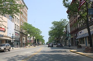
Ripon is a city in Fond du Lac County, Wisconsin, United States. The population was 7,733 at the 2010 census. The city is surrounded by the Town of Ripon.

Rosendale is a village in Fond du Lac County, Wisconsin, United States. The population was 1,063 at the 2010 census. The village is located partially within the Town of Rosendale and partially within the Town of Springvale.

Kewaskum is a town in Washington County, Wisconsin, United States. The population was 1,119 at the 2000 census. The incorporated community of Village of Kewaskum is surrounded geographically by the Town of Kewaskum. The unincorporated community of Saint Michaels is located partially in the town.

Kewaskum is a village in Washington and Fond du Lac counties in Wisconsin, United States. The population was 4,004 at the 2010 census. All of this population resided in the Washington County portion of the village. The village is mostly surrounded by the Town of Kewaskum.
Wisconsin's 6th congressional district is a congressional district of the United States House of Representatives in eastern Wisconsin. It is based in the rural, suburban and exurban communities between Madison, Milwaukee, and Green Bay. It also includes the village of River Hills in far northern Milwaukee County. The district is currently represented by Glenn Grothman (R-Glenbeaulah) who took office in January 2015.

State Trunk Highway 175 is a state highway in the US state of Wisconsin. It runs north–south in central Wisconsin from West Milwaukee to just south of Fond du Lac.

Forest Junction is an unincorporated census-designated place in the town of Brillion, Calumet County, Wisconsin, United States. As of the 2010 census, its population was 616.
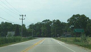
Taycheedah, Wisconsin is an unincorporated census-designated place in the Town of Taycheedah in Fond du Lac County, Wisconsin. The community is located adjacent to the city of Fond du Lac and Lake Winnebago. As of the 2010 census, its population is 704. Taycheedah calls itself the "Sheepshead Fishing Center of the World". U.S. Route 151 ran through the community until a bypass around Fond du Lac was built in the 2000s.

Peebles, Wisconsin is an unincorporated community in the Town of Taycheedah in Fond du Lac County, Wisconsin. The community is located adjacent to the unincorporated community of Taycheedah. U.S. Route 151 runs through the community. Wisconsin Highway 149 used to run through the community at its western terminus until it was decommissioned in 2006. Taycheedah Correctional Institution is located in the town of Taycheedah several miles south of the community.

Silica, Wisconsin is an unincorporated community in the Town of Taycheedah in Fond du Lac County, Wisconsin. It is located at the intersection of County Highway QQ and Silica Road, approximately 1 mile (1.6 km) north of St. Peter.

Mountain is an unincorporated census-designated place in Oconto County, Wisconsin, United States. The community is located at the intersection of Wisconsin Highway 32 and Wisconsin Highway 64, in the town of Mountain. It is located at latitude 45.185 and longitude -88.474 and elevation 971 feet. The postal code for Mountain is 54149. As of the 2010 census, its population is 363. Mountain has an area of 6.699 square miles (17.35 km2), all of it land.

Saxon is an unincorporated census-designated place located in the town of Saxon, Iron County, Wisconsin, United States. Saxon is located on Wisconsin Highway 122 11 miles (18 km) west-northwest of Hurley. Saxon has a post office with ZIP code 54559. As of the 2010 census, its population is 90.
Lake Tomahawk is an unincorporated census-designated place located in the town of Lake Tomahawk, Oneida County, Wisconsin, United States. Lake Tomahawk is located on Wisconsin Highway 47 15 miles (24 km) northwest of Rhinelander. Lake Tomahawk has a post office with ZIP code 54539. As of the 2010 census, its population was 228.
Woodhull is an unincorporated community located in the town of Lamartine, Fond du Lac County, Wisconsin, United States.


