Oakfield, Wisconsin

Last updated

Oakfield, Wisconsin
Fond du Lac County Wisconsin Incorporated and Unincorporated areas Oakfield Highlighted.svg
Location of Oakfield in Fond du Lac County, Wisconsin.
Coordinates: 43°41′3.1″N88°32′53.9″W / 43.684194°N 88.548306°W / 43.684194; -88.548306
Country Flag of the United States.svg  United States
State Flag of Wisconsin.svg  Wisconsin
County   Fond du Lac
Area
[1]
  Total0.99 sq mi (2.56 km2)
  Land0.98 sq mi (2.55 km2)
  Water0.00 sq mi (0.01 km2)
Elevation
[2]
860 ft (262 m)
Population
 (2020) [3]
  Total1,052
  Density1,106.82/sq mi (427.43/km2)
Time zone UTC-6 (Central (CST))
  Summer (DST) UTC-5 (CDT)
Area code 920
FIPS code 55-58925 [4]
GNIS feature ID1570697 [2]
Website villageofoakfield.com

Oakfield is a village in Fond du Lac County, Wisconsin, United States. The population was 1,052 at the 2020 census. The village is located within the Town of Oakfield.

Contents

History

A post office called Oakfield has been in operation since 1850. [5] The village was named for a grove of oak trees near the original town site. [6]

On July 18, 1996, an F5 tornado ripped through the village, destroying 47 homes but killing no one. [7]

Geography

Oakfield is located at 43°41′3″N88°32′54″W / 43.68417°N 88.54833°W / 43.68417; -88.54833 (43.684167, -88.548551). [8]

According to the United States Census Bureau, the village has a total area of 0.98 square miles (2.54 km2), all of it land. [9]

The Oakfield, Wisconsin tornado Oakfield Tornado 71896.jpg
The Oakfield, Wisconsin tornado

Demographics

Historical population
CensusPop.Note
1880 315
1910 522
1920 5566.5%
1930 5773.8%
1940 65513.5%
1950 6976.4%
1960 77210.8%
1970 91818.9%
1980 9907.8%
1990 1,0031.3%
2000 1,0120.9%
2010 1,0756.2%
2020 1,052−2.1%
U.S. Decennial Census [10]

2010 census

As of the census [3] of 2010, there were 1,075 people, 392 households, and 307 families living in the village. The population density was 1,096.9 inhabitants per square mile (423.5/km2). There were 415 housing units at an average density of 423.5 per square mile (163.5/km2). The racial makeup of the village was 96.9% White, 0.2% African American, 0.3% Native American, 0.4% Asian, 0.3% from other races, and 2.0% from two or more races. Hispanic or Latino of any race were 1.8% of the population.

There were 392 households, of which 36.7% had children under the age of 18 living with them, 66.1% were married couples living together, 8.7% had a female householder with no husband present, 3.6% had a male householder with no wife present, and 21.7% were non-families. 19.1% of all households were made up of individuals, and 7.9% had someone living alone who was 65 years of age or older. The average household size was 2.74 and the average family size was 3.13.

The median age in the village was 40.3 years. 26.2% of residents were under the age of 18; 8.6% were between the ages of 18 and 24; 22.7% were from 25 to 44; 29.7% were from 45 to 64; and 12.7% were 65 years of age or older. The gender makeup of the village was 49.3% male and 50.7% female.

2000 census

As of the census [4] of 2000, there were 1,012 people, 370 households, and 283 families living in the village. The population density was 1,049.9 people per square mile (407.0/km2). There were 384 housing units at an average density of 398.4 per square mile (154.4/km2). The racial makeup of the village was 98.42% White, 0.10% Black or African American, 0.30% Native American, 0.30% Asian, 0.59% from other races, and 0.30% from two or more races. 2.87% of the population were Hispanic or Latino of any race.

There were 370 households, out of which 39.5% had children under the age of 18 living with them, 63.5% were married couples living together, 7.8% had a female householder with no husband present, and 23.5% were non-families. 20.0% of all households were made up of individuals, and 10.8% had someone living alone who was 65 years of age or older. The average household size was 2.74 and the average family size was 3.15.

In the village, the population was spread out, with 28.5% under the age of 18, 7.0% from 18 to 24, 29.6% from 25 to 44, 23.3% from 45 to 64, and 11.6% who were 65 years of age or older. The median age was 36 years. For every 100 females, there were 98.0 males. For every 100 females age 18 and over, there were 101.1 males.

The median income for a household in the village was $51,053, and the median income for a family was $56,154. Males had a median income of $37,833 versus $24,625 for females. The per capita income for the village was $21,131. About 1.1% of families and 1.9% of the population were below the poverty line, including none of those under age 18 and 8.3% of those age 65 or over.

Notable people

Related Research Articles

<span class="mw-page-title-main">Burlington, Illinois</span> Village in Illinois, United States

Burlington is a village in Kane County, Illinois, United States. The population was 535 at the 2020 census, down from 618 in 2010. It was incorporated as a village on November 6, 1990.

<span class="mw-page-title-main">Oakfield, Maine</span> Town in the state of Maine, United States

Oakfield is a town in Aroostook County, Maine, United States. The population was 661 at the 2020 census. The village of Oakfield, listed as a census-designated place, is in the northwestern corner of the town.

<span class="mw-page-title-main">Boyd, Wisconsin</span> Village in Wisconsin, United States

Boyd is an autonomous village in the town of Delmar, Chippewa County, Wisconsin, United States. The population was 552 at the 2010 census.

<span class="mw-page-title-main">Metomen, Wisconsin</span> Town in Wisconsin, United States

Metomen is a town in Fond du Lac County, Wisconsin, United States. The population was 709 at the 2000 census. The villages of Fairwater and Brandon, the unincorporated community of Metomen, and the ghost town of Reeds Corners is also located in the town.

<span class="mw-page-title-main">Taylor, Wisconsin</span> Village in Wisconsin, United States

Taylor is a village in Jackson County, Wisconsin, United States, along the Trempealeau River. The population was 484 at the 2020 census.

<span class="mw-page-title-main">Union Center, Wisconsin</span> Village in Wisconsin, United States

Union Center is a village in Juneau County, Wisconsin, United States, along the Baraboo River. The population was 200 at the 2010 census.

<span class="mw-page-title-main">Brokaw, Wisconsin</span> Village in Wisconsin, United States

Brokaw is a former village in Marathon County, Wisconsin, United States. It is part of the Wausau, Wisconsin Metropolitan Statistical Area. The population was 251 at the 2010 census. Brokaw merged with the village of Maine, Wisconsin on October 1, 2018.

<span class="mw-page-title-main">Ontario, Wisconsin</span> Village in Wisconsin, United States

Ontario is a village in Vernon County, Wisconsin, United States. The population was 554 at the 2010 census.

<span class="mw-page-title-main">Big Falls, Waupaca County, Wisconsin</span> Village in Wisconsin, United States

Big Falls is a village in Waupaca County, Wisconsin, United States. The population was 61 at the 2010 census.

<span class="mw-page-title-main">Viola, Wisconsin</span> Village in Wisconsin, United States

Viola is a village in Richland (mostly) and Vernon Counties in the U.S. state of Wisconsin, United States. The population was 699 at the 2010 census. Of this, 477 were in Richland County, and 222 were in Vernon County.

<span class="mw-page-title-main">Oakfield (village), New York</span> Village in New York, United States

Oakfield is a village in Genesee County, New York, United States. As of the 2010 census, the village population was 1,813. The village lies within the town of Oakfield in northern Genesee County. The village is at the intersection of Route 63 and Route 262. It is northwest of Batavia.

<span class="mw-page-title-main">Oakfield (town), New York</span> Town in New York, United States

Oakfield is a town in Genesee County, New York, United States. The population was 3,250 at the 2010 census. The name of the town is derived from a number of trees, including the oak. The town is on the northern border of Genesee County. Within the town is a village also named Oakfield.

<span class="mw-page-title-main">Randolph, Wisconsin</span> Village in Wisconsin, United States

Randolph is a village in Columbia and Dodge Counties in the U.S. state of Wisconsin. The population was 1,811 at the 2010 census. Of this, 1,339 were in Dodge County, and 472 were in Columbia County. The village is located at the southeast corner of the Town of Randolph in Columbia County, although only a tiny portion of the village lies within the town. Most of the village lies within the Town of Westford in Dodge County. Small portions also lie within the Town of Fox Lake to the north and the Town of Courtland in Columbia County.

<span class="mw-page-title-main">Colfax, Wisconsin</span> Village in Wisconsin, United States

Colfax is a village in Dunn County, Wisconsin, United States. The population was 1,158 at the 2010 census. The village is surrounded by the Town of Colfax.

<span class="mw-page-title-main">Eden, Wisconsin</span> Village in Wisconsin, United States

Eden is a village in Fond du Lac County, Wisconsin, United States. The population was 875 at the 2010 census. The village is located within the Town of Eden.

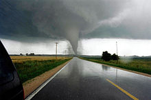
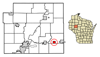
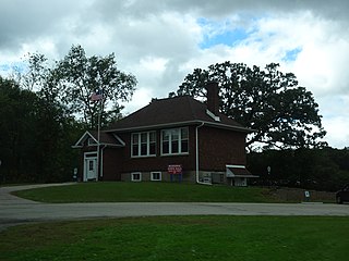
Oakfield is a town in Fond du Lac County, Wisconsin, United States. The population was 767 at the 2000 census. The Village of Oakfield is located within the town. The unincorporated community of Oak Center is also located in the town.

<span class="mw-page-title-main">Milltown, Wisconsin</span> Village in Wisconsin, United States

Milltown is a village in Polk County, Wisconsin, United States. The population was 917 at the 2010 census. The village is located within the Town of Milltown.

<span class="mw-page-title-main">Ironton, Wisconsin</span> Village in Wisconsin, United States

Ironton is a village in Sauk County, Wisconsin, United States, along the Little Baraboo River. The population was 253 at the 2010 census. The village is located within the Town of Ironton.

<span class="mw-page-title-main">Merrimac, Wisconsin</span> Village in Wisconsin, United States

Merrimac is a village in Sauk County, Wisconsin, United States, northwest of Madison. The population was 420 at the 2010 census. The village is located within the Town of Merrimac.

<span class="mw-page-title-main">Lohrville, Wisconsin</span> Village in Wisconsin, United States

Lohrville is a village in Waushara County, Wisconsin, United States. The population was 402 at the 2010 census.

References

  1. "2019 U.S. Gazetteer Files". United States Census Bureau. Retrieved August 7, 2020.
  2. 1 2 "US Board on Geographic Names". United States Geological Survey. October 25, 2007. Retrieved January 31, 2008.
  3. 1 2 "U.S. Census website". United States Census Bureau . Retrieved November 18, 2012.
  4. 1 2 "U.S. Census website". United States Census Bureau . Retrieved January 31, 2008.
  5. "Fond du Lac County". Jim Forte Postal History. Retrieved March 1, 2015.
  6. Chicago and North Western Railway Company (1908). A History of the Origin of the Place Names Connected with the Chicago & North Western and Chicago, St. Paul, Minneapolis & Omaha Railways. p. 109.
  7. Dougherty, Terri (January 1, 2011). Anatomy of a Tornado . Capstone. p.  20. ISBN   978-1-4296-6281-9.
  8. "US Gazetteer files: 2010, 2000, and 1990". United States Census Bureau. February 12, 2011. Retrieved April 23, 2011.
  9. "US Gazetteer files 2010". United States Census Bureau. Archived from the original on January 12, 2012. Retrieved November 18, 2012.
  10. "Census of Population and Housing". Census.gov. Retrieved June 4, 2015.
  11. 'Wisconsin Blue Book 1876,' Biographical Sketch of Edson A. Putnam, pg. 466
  12. 'Wisconsin Blue Book 1899,' Biographical Sketch of Henry A. Ripley, pg. 771
  13. 'Wisconsin Blue Book 1913,' Biographical Sketch of William F. Sommerfield, pg. 661